It is no secret that Israel had its eyes fixed on Bethlehem after it occupied the West Bank during the 1967 war; starting with annexing 18,048 Dunums (4512 acres) of the Governorateâ??s lands to the unilaterally expanded Israeli Jerusalem Municipal boundary, which by itself was annexed to the State of Israel. The history of the Israeli colonization activities in Bethlehem Governorate goes back to the early 1970s; where a systematic and methodical confiscation of Palestinian's lands became an epidemic nightmare. Today, the number of expanding illegal settlements reached 19 accommodating more than 77,376 Israeli settlers. The bulk of the settlements are located at the Gush Etzion bloc, which include 11 Israeli settlements 8 of which are within Bethlehem Governorate. The Segregation Wall around Gush Etzion bloc encompasses an area of 72,223 dunums and isolates them west of the Segregation Wall and off limits to the Palestinian land owners.
More New Hosing Units,
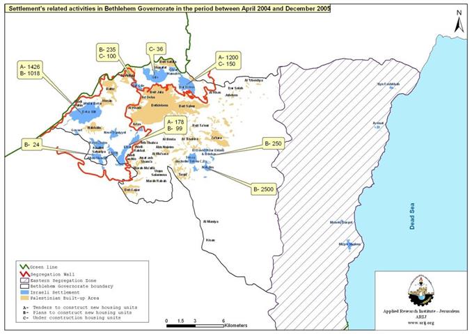
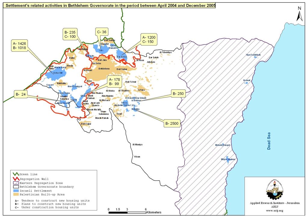
The period between April 2004 to December 25, 2005 witnessed an intense increase in the number of tenders putout by the Israeli government for additional building units in Israeli settlements in Bethlehem Governorate. The most recent addition to new housing units tenders was made on the day following Christmas; December 26, 2005, when the Israeli Housing Ministry published tenders for an additional 228 new housing units in Betar Illit (150) and Efrat (78) settlements of the Gush Etzion Bloc. The following table list tenders published by various Israeli bodies during the last 19 months in Bethlehem Governorate, where the number of tenders reached 2804 housing units in addition to 286 units that are under construction and 4182 planned Israeli units.
| Party involved | Under construction housing units | Plans to construct new housing units | Tenders to construct new housing units | Date | Settlement |
| Israeli ministry of building and construction | 700 | April 2004 | Abu Ghnaim (Har Huma) | ||
| 600 |
April 2004 |
Betar Illit | |||
| 100 |
April 2004 |
Efrat | |||
|
The Israeli Government |
|
2500 |
|
June 2004 |
Nokdim |
|
|
250 |
|
June 2004 |
Kfar Eldad | |
|
|
|
|
|||
| The Israeli Government | 100 | August 2004 | Har Gilo | ||
| The Israeli Government | 604 | August 2004 | Betar Illit | ||
|
The Israeli Government |
|
99 |
|
August 2004 |
Efrat |
|
The Israeli Government |
|
118 |
|
August 2004 |
Betar Illit |
|
Israel land Authority |
150 |
|
|
August 2004 |
Har Homa |
|
Israel land aithority |
36 |
|
|
August 2004 |
Gilo |
| Israel land authority | 200 | August 2004 | Har Gilo | ||
| The Keren Kayemt | 24 | February 2005 | Alon Shevot | ||
| 35 | February 2005 | Har Gilo | |||
| 500 | February 2005 | Betar Illit | |||
| Israeli Ministry of Housing & construction | 400 | June 2005 | Betar Illit | ||
| Israeli Ministry of Housing & construction | 72 | August 2005 | Betar Illit | ||
| Israeli Land Authority and the Israeli Ministry of Housing and Construction | 500 | August 2005 | Abu Ghneim (Har Homa) | ||
| Israeli ministry of building and construction |
|
150 |
December 2005 |
Betar Illit | |
| Israeli ministry of building and construction |
78 |
December 2005 |
Efrat | ||
| 286 | 4182 |
2804
|
|
Total |
Plans for New Settlements,
The year 2004 witnessed revelation of 3 new settlements plans in Bethlehem governorate with population capacity similar to the total current settlers population living in Bethlehem Governorate. The first settlement is Giva't Yael, to be located on the confiscated lands of the Palestinian village Al-Walajah (located 6 Km northwest of Bethlehem). The designated plan for the new settlement made the news on June 2004 as a private initiative and is set to include more than 13000 housing units to accommodate some 55000 new Israeli settlers. However, the significant magnitude of this settlement is that it constitutes the missing link to the ring of settlements, which extend from the northeastern sector of Bethlehem at Har Homa settlement and continues westward to Gilo settlement, then Har Gilo to Giva't Yael at the northwestern part and all the way to the Gush Etzion bloc, thus breaking up the geographical ties between Bethlehem and Jerusalem.
In September of the same year, the Israeli municipality of Jerusalem released its future vision of Jerusalem for the next 15 years under the name 'Master Plan Jerusalem 2000' in which two sites for two other new settlements were shown in the vicinity of Har Homa settlement located northeast of Bethlehem. Eventually, the two new settlements sites will bring the total areas of the three Har Homa settlements cluster to 2500 Dunums, an area large enough to accommodate some 25000 Israeli settler. The 'Master Plan Jerusalem 2000' still awaits various governmental and legal procedures before approvals before it pass through for execution.
The significance of Bethlehem to Jerusalem is diminishing if not lost under the chain of Israeli settlements barricading Jerusalem and separating it from its twin-ship with Bethlehem. Furthermore, closing off Bethlehem from Jerusalem will jeopardize the viability of the long anticipated Palestinian State as the geographical contiguity between the northern and southern parts of the West Bank will be no more.
Israeli Settlements and the Segregation Wall
In 2002, Israel started constructing the Segregation Wall under the pretext of security; however, the alignment of Segregation Wall has proven that its purpose goes beyond security but rather larceny of Palestinian's lands and encompassing illegally built settlements on lands occupied after the 1967 war. In Bethlehem district, the area isolated by the Israeli Segregation Wall include the aforementioned ring of settlements, In addition to substantial areas of Palestinian lands including the western rural areas of Bethlehem Governorate, which embrace Bethlehem's most fertile lands, parcels needed for future development of built-up areas and most importantly vital agricultural and water resources. The following table shows the extent of damages inflicted upon Bethlehem once the construction of the 52Km long Segregation Wall is completed, in addition to the overall status of the Governorate under Israeli occupation.
|
Bethlehem Governorate Geopolitical Classification |
Area In Km2 |
|||
|
Area 'A' Total Palestinian control |
48 |
|||
|
Area 'B' Palestinian Administration/ Under Israeli Security |
34 |
|||
|
Area 'C' Total Israeli control |
Of which fall West of the Segregation Wall |
|
|
|
|
Of which fall between the Eastern and Western Segregation Zones |
69 |
|||
|
Of which are Classified as 'Israeli Closed Military Area' |
286 |
|||
|
Total Area 'C' |
424 |
|||
|
Nature Reserve Area |
Of which accessible through Areas 'A' & 'B' |
|
|
|
|
Of which accessible only through Areas 'C' |
52 |
|||
|
Total Nature Reserve Area |
102 |
|||
|
|
|
|||
|
Total Bethlehem Governorate Area608 |
||||
The Israeli settlements related activities constitute a direct and predetermined Israeli violation of all signed agreement with the Palestinian, including the US backed Roadmap, which call and prohibit Israel from commencing any settlements related activities; including building new settlement and increasing the built-up areas of existing settlements even under pretext of controversial 'natural growth'.
Both Israeli Settlements and Segregation Wall stand in violation of various international laws as reaffirmed by the International Court of Justice (ICJ) ruling on July 9, 2004 and a continued lack of action and firmness on the part of the international community will undermine any prospects for an inclusive peace.
Prepared by:
The Applied Research Institute – Jerusalem