On Tuesday, December 20th, 2005, the Israeli bulldozers started excavating lands of Al Jaba'a and Surif villages located inside Bethlehem and Hebron governorates for the establishment of a new Border Crossing Point to the west of the two villages.
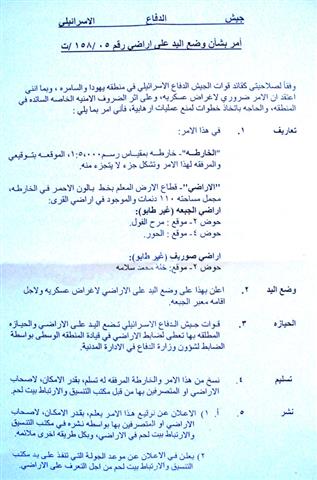
At the beginning of last month, farmers from Al Jaba'a village accidentally found a copy of a military order that was randomly thrown in their lands carrying the number of (T/158/05) and stipulating the confiscation of 110 dunums from Al Jaba'a and Surif lands for ' military purposes and for the establishment of Al Jaba'a border crossing'. See Copy of military order
According to the military order, the targeted lands are located in basins 2 and 4 of the two villages. See Map 1
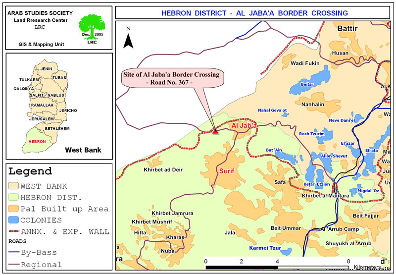
Map 1: location of the border crossing on regional road
number 367 to the west of Al Jaba'a
Location, population and area
The two border villages of Al Jaba'a and Surif are located about 15 km to the southwest of Bethlehem and 17 km to the north west of Hebron respectively. They are located about 3 km to the east of the Armistice Line (Green Line). Al Jaba'a with a total population of 800 inhabitants and land area of 10099 dunums, including 1002 dunums as built up area, is affiliated to Bethlehem district. Surif village with a total population of 13000 inhabitants and land area of 15034 dunums, including 5097 dunums as built up area is affiliated to Hebron district.
Continuous land expropriation
In 1956, about 1000 dunums of Al Jaba'a and Surif villages' lands were lost to Israel in an area called Khur Musa. In addition, the path of the Segregation Wall has been completed to the west of the two villages segregating behind another 1000 dunums of agricultural lands. Yet, another 2000 dunums of cultivated lands will be segregated behind the Wall once established to the north of the two villages (from Gush Etzion in the east to the current Israeli checkpoint on road number 367 in the west which extends from the Gush Etzion settlement Bloc, mainly from the settlement of Geva'ot, passing by the settlement of Kfar Etzion and heading towards Beit 'Ayn and Migdal 'Oz settlements southwestern Bethlehem.
According to the Israeli wall plan of October 2003, the village of Al Jaba'a was part of the area segregated behind the Wall. But, the latest Israeli Wall plan published on the Israeli Ministry of Defense website on February 20th, 2005, Al Jaba'a village was taken out of the segregated lands; however, it will be besieged by the Wall from north, east and west and bypass road number 367 from south, hence, disconnecting its geographical continuity from the nearby Surif village. Historically speaking, the two neighboring villages constituted one geographical and human entity until the year 2000 when the Israeli army bulldozers closed with earth mounds the only passage way between the two villages prohibiting Palestinian vehicular movement on road 367 separating between the two villages.
The new border crossing
The site of the new border crossing is about 2 km to the east of the Armistice Line (Green Line) and 1 km to the west of Al Jab'a village. The current Israeli permanent checkpoint is only 300 meters to west of the proposed site (See Map 1 & Photo 1).

Photo 1: the current Israeli military checkpoint on road No. 367-
(Photo courtesy of LRC).
According to the Israeli army, the border crossing will serve as a commercial crossing point between Israel and the occupied territory. Similar crossings have been inaugurated in other areas of the West Bank such as Gilo 300 border crossing in Bethlehem and Qalandyia border crossing while others are still under construction such as the one to the west of Qalqiliya Governorate. For the Israelis, these crossings will serve as bridges to sell and smuggle Israeli products into the West Bank markets. By so doing, Israel will continue its hegemony over the Palestinian economy and guarantee the dependency of Palestinian economy on Israel. In the meanwhile, trade between the West Bank and abroad will be tightly controlled by Israel and could be hindered at any moment of time by Israel under any security pretext or as means of political pressure or collective punishment. See Photo 2
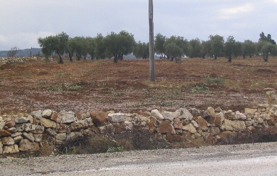
Photo 2: Destroyed olive orchards to the left of road No. 367
(Photo courtesy of LRC)
For Palestinians, the border crossings are part of the segregation Wall plan which aims at further suffocating the Palestinian life and economy. Like the Wall, they have been built or planned to be built inside the occupied territory, hence confiscating more areas of Palestinian owned lands.
Legal actions
In an interview with LRC field worker, a number of Al Jab'a farmers said that after finding the copy of the order in their lands, they headed to the Israeli ' civil administration' office in Gush Etzion taking with them all related land ownership documents. There, they filled an objection to the Israeli military objections committee and another one to the government's legal advisor. See Photo 3
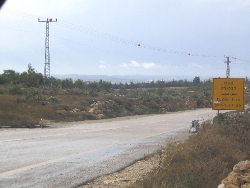
Photo 3: threatened olive orchards to the left of the road
(Photo courtesy of LRC)
A week later, a delegation formed of the deputy legal advisor, the deputy commander of the army's central command and a surveyor representing 'the ministry of defense' visited the projected site. Farmers of Al Jaba'a who were also present at the scene asked the delegation to build the border crossing on their uncultivated lands which were confiscated in 1956 to the west of the Armistice Line (Green Line), but, the delegation refused and insisted to have the border crossing built on the disputed location.
On Tuesday, December 20th, Israeli bulldozers protected by huge army force started excavating the land and uprooting the trees. So far, more than 100 fruitful olive trees have been uprooted from the site to make room for the construction of the crossing border.
After this development, the victims authorized lawyers Ghaiyath Nasser and Usama Halabi to defend their case in Israeli courts. On December 22nd, 2005, a precautionary decision was issued by an Israeli court upon request from the two afore-mentioned lawyers stipulating an immediate halt of all works at the site. See Photo 4
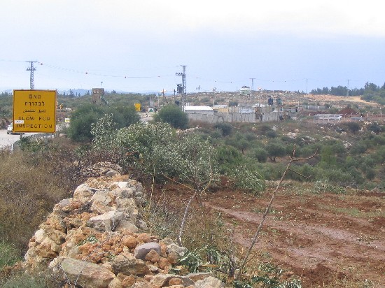
Photo 4: the current Israeli military checkpoint and the new land
(Photo courtesy of LRC)(Photo courtesy of )
Following, is a table of affected people by name, area, number of trees and type of trees:
|
No. |
Name |
Area in dunum |
No. of trees |
Type of tree |
|
1 |
Ahamd Abdul Hamid Attus |
20 |
150 |
Olive |
|
2 |
Ahamd Mohammed Abu Latifa |
6 |
100 |
Peach and almond |
|
3 |
Ahamd Abdul Latif Abu Latifa |
6 |
100 |
Olive |
|
4 |
Ali Abdul Majid Hamdan |
3 |
70 |
Olive |
|
5 |
Ali Abdul Hamid Attus |
6 |
50 |
Olive |
|
6 |
Naji Ahmad Abu Latifa |
7 |
150 |
Olive |
|
7 |
Ibrahim Mahmud Abu Loha |
5 |
100 |
Olive |
|
8 |
Isma'il Abu Loha |
3 |
40 |
Olive |
|
9 |
Mustafa Abu Loha |
3 |
40 |
Olive |
|
10 |
Sa'id Mohammed Hamdan |
9 |
100 |
Olive |
|
11 |
Ibrahim Abdul Qader Al Hur |
2 |
Cereals |
— |
|
12 |
Ibrahim Abdul Hamid Attus |
4 |
50 |
Olive |
|
13 |
Mahmud Attiya Attus |
6 |
70 |
Olive |
|
14 |
Wajieh Ibrahim Hamdan |
3 |
50 |
Olive |
|
15 |
Musa Hmadan Masha'la |
7 |
100 |
Olive |
|
16 |
Ahamd Hasan Mansur |
20 |
200 |
Olive |
|
|
Total |
110 |
1370 |
|
Prepared by


