• About The Project
  • Palestine in Century
  • Selected Maps
  • Glossary
  • About ARIJ
  • About LRC
  • By Year
    • Case Studies By Year
    • Daily Report By Year
Friday, October 3, 2025
POICA
No Result
View All Result
  • Home
  • Settlements
    • New Israeli Settlements
    • Settlement Expansion
  • Israeli Violations
    • Agriculture
    • Confiscation
    • Demolition
    • Environment
    • Eviction of Palestinians
    • Settlers Attacks
  • Bypass Roads
  • Israeli Plans
  • Segregation
    • Checkpoints
    • Closure
    • Separation Plans
  • Military Orders
  • Reports
    • Daily Report
    • Monthly Report
    • Quarterly Report
No Result
View All Result
POICA
No Result
View All Result

Sliced & Diced: The Israeli Corridors and the Future of a Palestinian State !!!

March 2, 2017
in Israeli Plans
Sliced & Diced: The Israeli Corridors and the Future of a Palestinian State !!!

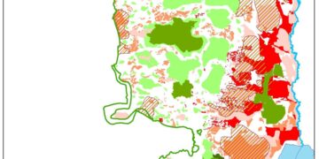
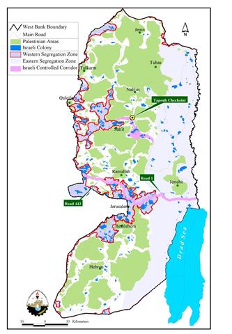
It seems that Israel's plans do not stop at snatching 10% (565 Km2) along the western terrains of the occupied West Bank territory with the ongoing – near complete construction of the Segregation Wall and the isolation of 29% (1664 Km2) along the eastern terrains, but it breaks up the area remaining 'in between' into three regions (north, central & south); separated from each other by two Israeli controlled corridors enclosing Israeli settlements clusters, earth mounds, cement blocs, popup checkpoints and permanent checkpoints. The northern region will include the four Palestinian Governorates; Jenin, Nablus, Tulkarem and Qalqilyia; the central region will include Ramallah and Jericho Governorates; whereas the southern region will include Bethlehem and Hebron Governorates. As for East Jerusalem, the Israeli plan did not include it in any of the regions but was considered a natural extension of the Israeli territorial grounds. See Map of Corridors

According to Haaretz of an Israeli military source, crossing from the northern region to the central region will only be possible through a 10 lanes main checkpoint situated below the hilltop on which the Israeli Tapouh settlements is seated. The checkpoint that will start operating at the end of January 2006 will run security inspection on all Palestinian vehicles crossing the checkpoint. Just like the current checkpoint located at the central region, Qlandyia, Palestinians will go through a humiliating process before they are allowed to cross the checkpoint, the long hours of waiting in turn, the mood swings of the Israeli soldiers who find it easy enough for them to close the checkpoint at their will; with no regard to time wasted and delays that the Palestinians has to coarsely endure.

Qalandyia checkpoint is the other crossing, which will enable Palestinians to travel between the southern region, central and northern regions and vice versa. The corridor extends from the Israeli Mod'in settlement bloc to Qlandyia checkpoint on the Israeli Highway number '443', a road with exclusive use to Israelis. The corridor continues after it reaches Qalandyia checkpoint and continues eastward on Israel's Highway '1' where Palestinian use is subjected to Israeli restrictions.      

The Israeli settlements located in these corridors are the ones that Israel plans to hold on to undermine any peace agreement with the Palestinians and even though Israel do have the intention to evacuate more of its settlements in the occupied West Bank territory, it does not include the settlements located in the two corridors. The strategic locations of these corridors allows Israel to maintain access with the Jordan Valley area where 43 Israeli settlements (population 10,500) are located and also comprehensive and firm grip of the internationally recognized boundary with Jordan against any case scenario of infiltration or attack. In addition, Israeli settlers living in settlements located in the corridors will have a secure and direct access with Israel, but more importantly, the existence of these settlements will sustain life to Israel's colonization project. On the other hand, the locations of the corridors will facilitate Israeli incursions into Palestinian controlled areas, more than that, Israel will ensure to disperse of Palestinian's aspiration of a geographically contiguous, independent State of their own.

According to Israeli military sources, 'the checkpoint is intended to speed up the current system of security checks and prevent jams'; however, it is in the best interest of all those involved to abandon the checkpoints and corridors plan and dismantle all kinds of obstacles installed through out West Bank area.


Prepared by:  
The Applied Research Institute – Jerusalem


Recommended For You

Annexation of the Jordan Valley: Implications for the Two-State Solution and Regional Stability

by arij
September 29, 2025
0
Annexation of the Jordan Valley: Implications for the Two-State Solution and Regional Stability

  The potential annexation of the Jordan Valley by Israel, emboldened by U.S. President Donald Trump’s second term and supported by Prime Minister Benjamin Netanyahu’s far-right coalition, presents...

Read moreDetails

عزل ثلاث قرى فلسطينية شمال غرب مدينة القدس: الضم الاسرائيلي الصامت يزحف نحو محيط العاصمة

by arij
September 24, 2025
0
Isolation of Three Villages Northwest of Jerusalem: Silent Annexation Creeps toward the Capital

مقدمة في خطوة تجسد سياسة الضم الزاحف التي تنتهجها إسرائيل منذ عقود، وجدت ثلاث قرى فلسطينية تقع إلى الشمال الغربي من مدينة القدس، بيت إكسا، النبي صموئيل، وحي...

Read moreDetails

Isolation of Three Villages Northwest of Jerusalem: Silent Annexation Creeps toward the Capital

by arij
September 24, 2025
0
Isolation of Three Villages Northwest of Jerusalem: Silent Annexation Creeps toward the Capital

Introduction In a move that embodies Israel’s creeping annexation policy pursued for decades, three Palestinian villages located northwest of Jerusalem: Beit Iksa, Nabi Samuel, and Al-Khalaila, suddenly found...

Read moreDetails

سياسات التهويد في القدس: من السيطرة المكانية إلى طمس الهوية عبر التسمية

by arij
September 23, 2025
0
سياسات التهويد في القدس: من السيطرة المكانية إلى طمس الهوية عبر التسمية

المقدمة تشكل سياسات تغيير الأسماء إحدى الأدوات الأكثر عمقا وخطورة في المشروع الاستعماري الإسرائيلي، إذ لا تقتصر على البعد الإداري أو التقني، بل تمتد إلى جوهر الهوية والذاكرة...

Read moreDetails

Judaization Policies in Jerusalem:  From Spatial Control to Identity/ Naming Theft

by arij
September 23, 2025
0
Judaization Policies in Jerusalem:  From Spatial Control to Identity/ Naming Theft

Introduction The policy of changing place names represents one of the most profound and dangerous tools in the Israeli colonial project. It extends beyond administrative or technical concerns...

Read moreDetails
Next Post
Jubara … A Prototype Aftermath of the Israeli Segregation Wall

Jubara ... A Prototype Aftermath of the Israeli Segregation Wall

LATEST NEWS

Annexation of the Jordan Valley: Implications for the Two-State Solution and Regional Stability

Annexation of the Jordan Valley: Implications for the Two-State Solution and Regional Stability

by arij
September 29, 2025
0

........................................................

Isolation of Three Villages Northwest of Jerusalem: Silent Annexation Creeps toward the Capital

عزل ثلاث قرى فلسطينية شمال غرب مدينة القدس: الضم الاسرائيلي الصامت يزحف نحو محيط العاصمة

by arij
September 24, 2025
0

........................................................

Isolation of Three Villages Northwest of Jerusalem: Silent Annexation Creeps toward the Capital

Isolation of Three Villages Northwest of Jerusalem: Silent Annexation Creeps toward the Capital

by arij
September 24, 2025
0

........................................................

سياسات التهويد في القدس: من السيطرة المكانية إلى طمس الهوية عبر التسمية

سياسات التهويد في القدس: من السيطرة المكانية إلى طمس الهوية عبر التسمية

by arij
September 23, 2025
0

........................................................

flag_yellow_lowEU-PfP-Logo

This website and its content were initiated in 1993 by the Applied Research Institute – Jerusalem (ARIJ) and the Land Research Center (LRC) with the support from the European Union up until 2023. Since then, the Applied Research Institute – Jerusalem (ARIJ) has taken over the continued development and maintenance of the website. The views expressed remain solely those of ARIJ) and do not necessarily reflect those of the European Union.

© 2025 Copyright ARIJ . All Rights reserved. .

No Result
View All Result
  • Home
  • Settlements
    • New Israeli Settlements
    • Settlement Expansion
  • Israeli Violations
    • Agriculture
    • Confiscation
    • Demolition
    • Environment
    • Eviction of Palestinians
    • Settlers Attacks
  • Bypass Roads
  • Israeli Plans
  • Segregation
    • Checkpoints
    • Closure
    • Separation Plans
  • Military Orders
  • Reports
    • Daily Report
    • Monthly Report
    • Quarterly Report

© 2025 Copyright ARIJ . All Rights reserved. .