Area, location and Population: –
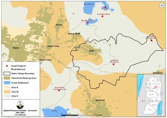
Salem, a Palestinian village located 4.46 km to the east of Nablus city and reaches up to approximately 530 meters above the sea level. The village's population recorded 422 inhabitants in the year 1922; however, according to the Palestinian state information service (SIS), the population continued to grow and reached up to 2075 and 3703 inhabitants in the years 1987 and 1996, respectively. Today, the village's population is about 5500 according to the latest survey conducted by the Palestinian Central Bureau of Statistics (PCBS 2005) and occupies an area of 10294 dunums classified as Area B (3134 dunums) and Area C (7160 dunums). See Map of Salem village
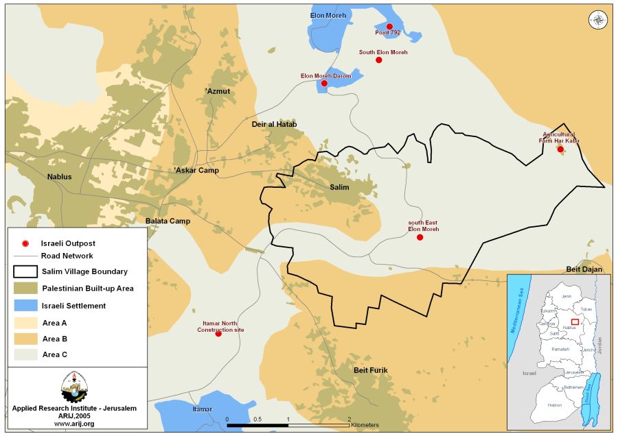
The village of Salem is surrounded by 'Askar camp from the west, Balata Camp from the southwest, Deir Al Hatab from the northwest, Beit Furik from the south, Beit Dajan and the Valleys from the east and southeast, the set of Elon Moreh Israeli settlement (Elon Moreh _mother settlement, Point 792, South Elon Moreh outpost and Elon Moreh Darom) in the north. See Table 1
|
Site Name |
Population |
Location |
Date of Establishment |
Area (km 2) |
|
Elon Moreh |
1,200 |
|
1979 |
1.396 |
|
Point 792 |
Dismantled in 2003 |
Almost 4 km south east of the settlement |
January 1999 |
NA |
|
Elon Moreh South |
Four families |
3.5 km south-east of Elon Moreh settlement |
August 2002 |
NA |
Source: ARIJ Data base- GIS
The village like other Palestinian villages and towns in the West Bank has undergone harsh measures either at the hands of Israeli forces (IOF) or Israeli settlers from the nearby Israeli settlement (Elon Moreh) varying from Land confiscation, to uprooting of fruitful trees and other harassments.
Salem's Village Land Classification
Salem village is an agricultural community in that the majority of its lands (39%) are classified as arable lands where a wide variety of Fruitful trees are cultivated, most Old Roman Olive trees. In addition, the village is famous for its field cultivations wherabout 18% of its lands are utilized for that purpose. Moreover, 35% of the village's lands are classified as open spaces and fall within Area 'C', under the full Israeli Control according to Oslo Agreements classifications in 1993. The open spaces are the only areas through which the village can expand and develop in the future. Table 2 below details the Land Use and Land Cover of Salem village.
Table 2: The land classification inside the village boundary
|
Land classification Land Use Land Cover |
Area / Dunums |
Percentage |
|
Arable land |
4062 |
39% |
|
Open spaces with little or no vegetation |
3604 |
35% |
|
Shrub and/ or herbaceous vegetation associations |
83 |
0.8% |
|
Permanent crops |
1877 |
18% |
|
Palestinian Built-up |
668 |
6.4% |
|
Total |
10294 |
|
Source: ARIJ GIS Database 2005
Cutting of Olive trees
Since October 2000, the Israeli occupying forces and Israeli settlers have engaged in continuous attacks upon the Palestinian agriculture and mainly on the Olive farming which severely affected the economy the Palestinian communities who dependent upon Olives for their livelihood. About 45 percent of the lands in the West Bank are cultivated with Olive trees according to the Palestinian Central Bureau of Statistics (PCBS 2002-2003). Huge numbers of Olive and fruitful trees have been systematically uprooted and destroyed in Salem village. An analysis conducted by the Applied Research Institute – Jerusalem showed that about 650 Olive trees were uprooted in the village of Salem since the beginning of this year and till the date of this article. It is worth mentioning that the estimated loss per each uprooted Olive tree in Palestine is NIS 100 ($22);
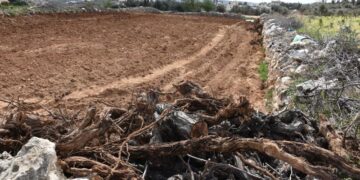
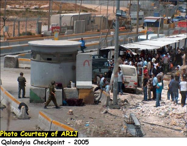
On November 27, 2005, a group of Israeli settlers from Elon Moreh settlement east of Nablus city aggressed on Salem village lands at night and destroyed more than 200 Old Roman Olive trees owned by Palestinian families in the village. The village has been subjected to a number of attacks during the past few weeks, the most recent was when a group of Israeli settlers set fire to 300 dunums of lands planted with Olive trees belonging to the village (October 18, 2005). The attacks started when an Israeli settler from Elon Moreh called Gid'on established a new settlement outpost on Al Luhhaf area, about 4 Km to the east of Salem village in an attempt to expand the area the mother settlement. Two other settlement outposts were constructed on the lands of Salem during the last couple of years, one to the east and another to the southeast,' Agricultural Farm-Har Kabir' and' South east Elon Moreh' outposts. See Photo 1 and Photo 2. and .

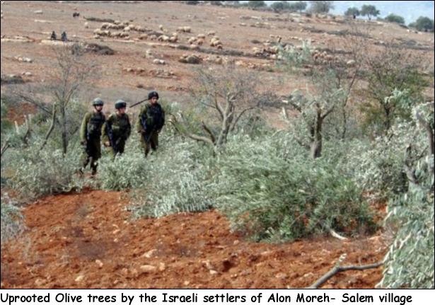
Photo Courtesy of Naser Ishtayah
Another Israeli bypass Road number '557' runs through the lands of Salem village from north to south and links Itamar settlement in the south with Elon Moreh settlement in the north. Today Palestinians are prohibited from traveling on this road despite the fact that this same road served the village's residents and the nearby Palestinian villages such as Beit Furik, Beit Dajan, and Deir Al-Hatab. The bypass road extends 4.564 km on lands of Salem and isolates the open spaces which constitute 35% of village's total area from the built-up area itself.
Conclusion:-
The Israeli settlement policy in the occupied territory on lands belonging to Palestinians is a clear violation of international law, including numerous United Nations Resolutions and crucial provisions of The Hague Regulations of 1907 and the Fourth Geneva Convention of 1949. The Fourth Geneva Convention expressly categorizes such actions as War Crimes (Article 147).
-
The Hague Regulations expressly forbids an occupying power 'to destroy or seize the enemy's property, unless such destruction or seizure is imperatively demanded by the necessities of war' (Article 23).
-
The Fourth Geneva Convention, the primary document of international law governing instances of military occupation, states in Article 49 that: 'The occupying power shall not deport or transfer parts of its own population into the territories it occupies.'
-
Article 53 of the Fourth Geneva Convention is also clear that: 'any destruction by the Occupying Power of real or personal property belonging individually or collectively to private persons, or to the State, or to other public authorities, or to social or cooperative organizations, is prohibited, except where such destruction is rendered absolutely necessary by military operations.'
-
The appropriation and destruction of Palestinian land is an especially serious violation of the Fourth Geneva Convention, Article 147 of which clearly prohibits, ''extensive destruction and appropriation of property, not justified by military necessity and carried out unlawfully and wantonly.'' Violations of Article 147 constitute grave breaches of the Convention and should be prosecuted as War Crimes.
References:-
-
'http://www.pnic.gov.ps.' Palestinian National Information Center. 1 December 2005, http://www.pnic.gov.ps/arabic/palestine/palestinea.html..
-
'Forbidden Roads: The Discriminatory West Bank Road Regime.' http://www.btselem.org. 01 August 2004. The Israeli Information Center for Human Rights in the Occupied Territories. .
-
'Settlement growth in the Territories.' http://www.peacenow.org.il. Peace Now. 01 December 2005 http://www.peacenow.org.il/site/en/peace.asp?pi=58..
Prepared by:
The Applied Research Institute – Jerusalem