• About The Project
  • Palestine in Century
  • Selected Maps
  • Glossary
  • About ARIJ
  • About LRC
  • By Year
    • Case Studies By Year
    • Daily Report By Year
Sunday, May 11, 2025
POICA
No Result
View All Result
  • Home
  • Settlements
    • New Israeli Settlements
    • Settlement Expansion
  • Israeli Violations
    • Agriculture
    • Confiscation
    • Demolition
    • Environment
    • Eviction of Palestinians
    • Settlers Attacks
  • Bypass Roads
  • Israeli Plans
  • Segregation
    • Checkpoints
    • Closure
    • Separation Plans
  • Military Orders
  • Reports
    • Daily Report
    • Monthly Report
    • Quarterly Report
No Result
View All Result
POICA
No Result
View All Result

Resumption of Wall constructions in Kafr Thulth and Azzun lands – Qalqiliya governorate

March 9, 2017
in Separation Plans
Resumption of Wall constructions in Kafr Thulth and Azzun lands – Qalqiliya governorate

On August 6, 2005, the Israeli army resumed work constructions in the Segregation Wall in Kafr Thulth and Azzun, in Qalqiliya governorate, after a 5 months halt in response to the Israeli high court's decision issued following a series of objections on part of Palestinian landowners and farmers in the targeted areas.

The total area of lands confiscated for this section of the Wall is 224 dunums, out of which, 110 dunums are located in the eastern part of Kafr Thuluth, particularly, in the areas of Ikhribat, Khaller Lora, Salama and Khallet Al Arz. The remaining 114 dunums are, also, located in the eastern part of Azzun in the areas of Ashifa, Um Al Khouf, At Tarbi'a and Al Kaffan. The total length of this section of the Wall is 2.1 km with an average width of 100 meters.

Location and population

The town of Kafr Thulth is located 6 kilometers away from the Green Line. Its lands extend from the town of Azzun in the north to the town of Sanniriya in the south, the Green Line in the west and the town of Deir Istiya in the east. It is, also, located 12 kilometers southeast Qalqiliya city. As for the latest population statistics (as late as year 2002), it indicates that the current population of the village is about 5,000.

The town is considered the 'mother' village of the following 'sub-villages': Izbat Salman, Izbat Jal'ud, Izbat Al Madwar, Ras at Tira, Ras Atiya, Al Daba' and Wadi ar Rasha. As such, the town of Kafr Thuluth and its satellite villages are considered one unit in terms of population and agricultural lands.

Following the 1948 War, 20% of the towns' lands which amounts to about 4,000 dunums were occupied. Two Israeli settlements were established on these occupied lands which became part of Israel's proper; the settlement of Nahal Yarhiv which was built atop of the ruins of the Palestinian town of Khraish and the settlement of Nirit which was built in a location called Ahrash Al Zaqoor. The remaining 80% of the land of the town remained within the borders of the West Bank.

The town of Azzun is located to the northeast of Kafr Thulth and it is about 8 km to the east of Qalqiliya city. It has the population of about 5200 inhabitants. See map 1: location map  : location map 

Land and trees threatened by the Wall

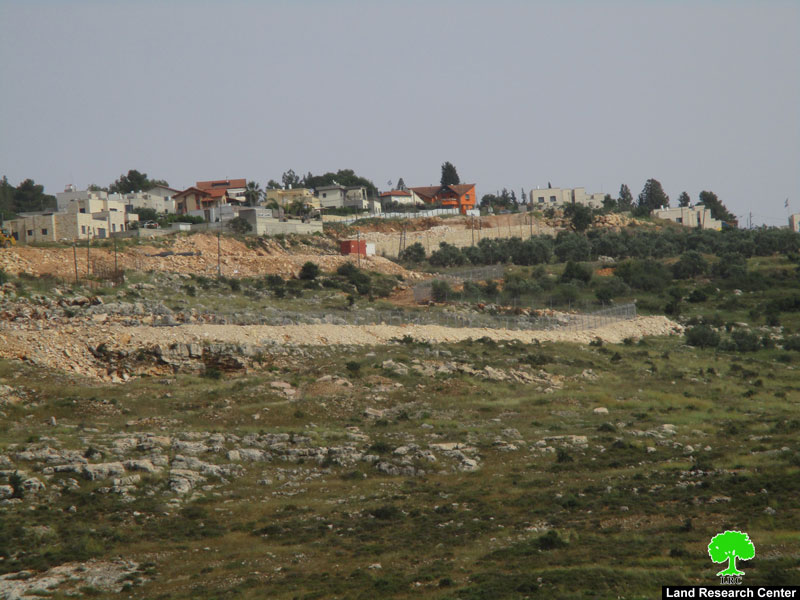
It is expected that a total of 598 dunums of Kafr Thuluth's lands will be segregated behind the wall once it is constructed. Out of the total, at least 58 dunums will be separated by the erection of the Wall around Ma'ale Shomron Israeli settlement located to the north east of the village of Kafr Thulth. This settlement was established in the year 1980 and it had the population of 549 in the year 2004, according to the statistics of the Foundation for Middle East Peace 2004. See photo 1: a general view of Kafr Thulth with the Wall path in the background. : a general view of Kafr Thulth with the Wall path in the background.


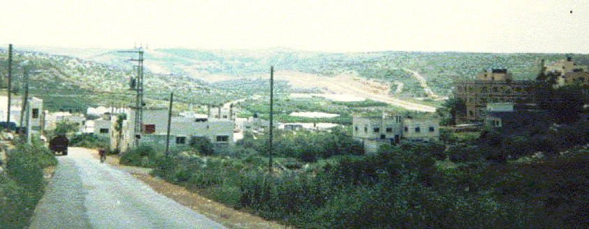
Photo courtesy o LRC

Another 1150 dunums of forest and olive planted lands are expected to become separated behind the Wall once it is completed on Azzun lands. Moreover, the Wall will lead to the uprooting and destruction of about 2400 long lived olive trees in these two villages.

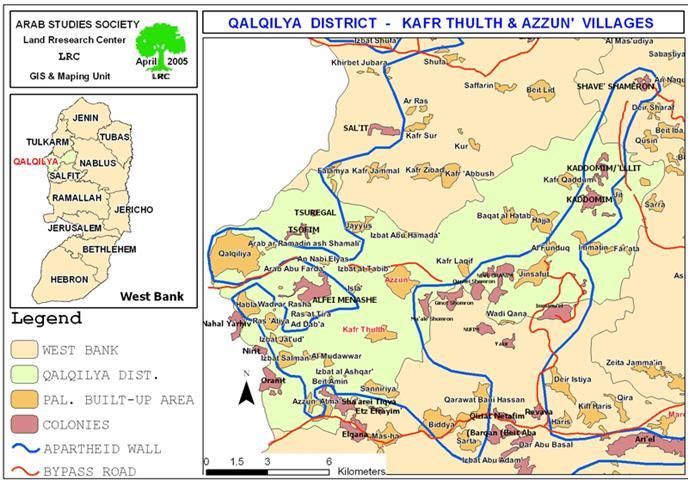
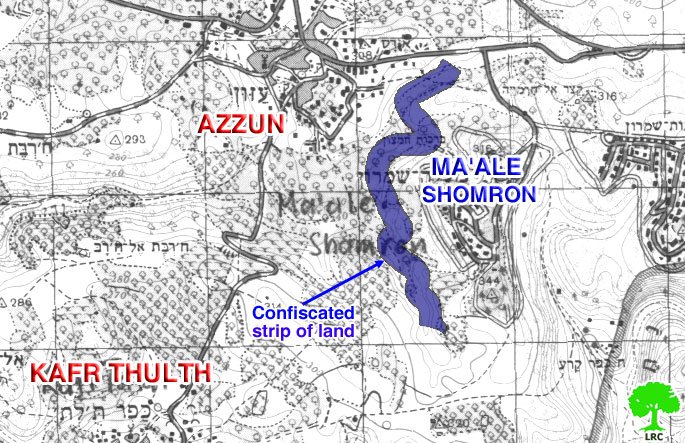
It is worth mentioning that this Wall section is part of a five-section plan being implemented in Salfit and Qalqiliya districts with the aim of surrounding all the Israeli settlements in these two governorates with Wall belt as to ensure the annexation of these settlements located in the West Bank into Israel's proper under the name of Ariel finger (corridor). These settlements include, among others; Emmanuel, Ma'ale Shomron, Kedumim, and Ariel. See Map 2: a topographical map showing the path of the Wall in Azzun and Kafr Thulth lands.  : 

Affected Palestinians along with their foreign and local supporters led a number of protests and peaceful marches in protest against the Israeli plans in the Governorate, but, they were quelled with excessive force at the hands of Israeli soldiers and security personnel. 


Prepared by
The Land Research Center
LRC


Recommended For You

إغلاق مداخل قرية دير نظام بالتزامن مع إقامة مقطع جديد من السياج الفاصل / محافظة رام الله

by arij
June 25, 2019
0
The Israeli occupation violates human rights in Deir Nitham / Ramallah governorate

  الانتهاك: إقامة مقطع جديد من السياج الفاصل وإغلاق مداخل القرية. الموقع: قرية دير نظام شمال مدينة رام الله. تاريخ الانتهاك: 13/02/2019. الجهة المعتدية: جيش الاحتلال الإسرائيلي. الجهة...

Read moreDetails

The Israeli occupation violates human rights in Deir Nitham / Ramallah governorate

by arij
June 25, 2019
0
The Israeli occupation violates human rights in Deir Nitham / Ramallah governorate

  Violation: closing the town’s entrance and establishing a new segment of the apartheid wall. Location: Deir Nitham village north Ramallah city. Date: 13/02/2019. Perpetrator:  The Israeli occupation...

Read moreDetails

Info-graph: Manipulating the Demography of Occupied East Jerusalem
“The Construction of the Israeli Segregation Wall in and around Jerusalem

by arij
January 16, 2019
0
Info-graph: Manipulating the Demography of Occupied East Jerusalem “The Construction of the Israeli Segregation Wall in and around Jerusalem

  When Israeli captured East Jerusalem along with other Arab-Palestinian territories during the 1967 war, it became an obsession of the successive Israeli governments to win the demographic...

Read moreDetails

جيش الاحتلال الاسرائيلي ينصب بوابة حديدية جديدة شمال مدينة سلفيت

by arij
July 3, 2018
0
جيش الاحتلال الاسرائيلي ينصب بوابة حديدية جديدة شمال مدينة سلفيت

  الانتهاك: نصب بوابة حديدية على مدخل طريق زراعي شمال سلفيت. الموقع: مدينة سلفيت.. تاريخ الانتهاك: 21 حزيران 2018م. الجهة المعتديه: جيش الاحتلال الإسرائيلي. الجهة المتضرره: المزارعون في...

Read moreDetails

Israel to build new segment of the apartheid wall around “Ma’ale Isreal”

by arij
December 10, 2018
0
Israel to build new segment of the apartheid wall around “Ma’ale Isreal”

violation: completing the construction of the apartheid wall Location: Sarta Ash-Sharqiya village/ Salfit Governorate. Date:  May 01 - 2018 Perpetrators: Israeli Occupation Forces Victims:  residents of Sarta Description:...

Read moreDetails
Next Post
New Israeli tenders to expand Har Homa (Abu Ghneim) settlement

New Israeli tenders to expand Har Homa (Abu Ghneim) settlement

LATEST NEWS

الأراضي الفلسطينية بين الذرائع الأمنية والأطماع الاستيطانية – “الأمن، الآثار، والطبيعة كحجج لاقتلاع الفلسطينيين من أراضيهم”

by arij
April 15, 2025
0

........................................................

الطرق الالتفافية الاسرائيلية وأثرها على البيئة الفلسطينية

انتهاك للطبيعة والهوية في الأراضي الفلسطينية المحتلة

by arij
March 17, 2025
0

........................................................

Israel Advances Settlement Plan on Ancient Olive Groves on lands of Beit Jala city, Violating International Law and depriving Palestinians their lands

إسرائيل تمضي قدمًا في مخطط استيطاني جديد على أراضي مدينة بيت جالا، في انتهاك للقانون الدولي وحرمان الفلسطينيين من أراضيهم

by arij
April 29, 2025
0

........................................................

Israel Advances Settlement Plan on Ancient Olive Groves on lands of Beit Jala city, Violating International Law and depriving Palestinians their lands

Israel Advances Settlement Plan on Ancient Olive Groves on lands of Beit Jala city, Violating International Law and depriving Palestinians their lands

by arij
April 29, 2025
0

........................................................

flag_yellow_lowEU-PfP-Logo

This website has been produced with the assistance of the European Union. The contents of this publication are the sole responsibility of ARIJ & LRC and can in no way be taken to reflect the views of the European Union.

© 2025 Copyright ARIJ . All Rights reserved. .

No Result
View All Result
  • Home
  • Settlements
    • New Israeli Settlements
    • Settlement Expansion
  • Israeli Violations
    • Agriculture
    • Confiscation
    • Demolition
    • Environment
    • Eviction of Palestinians
    • Settlers Attacks
  • Bypass Roads
  • Israeli Plans
  • Segregation
    • Checkpoints
    • Closure
    • Separation Plans
  • Military Orders
  • Reports
    • Daily Report
    • Monthly Report
    • Quarterly Report

© 2025 Copyright ARIJ . All Rights reserved. .