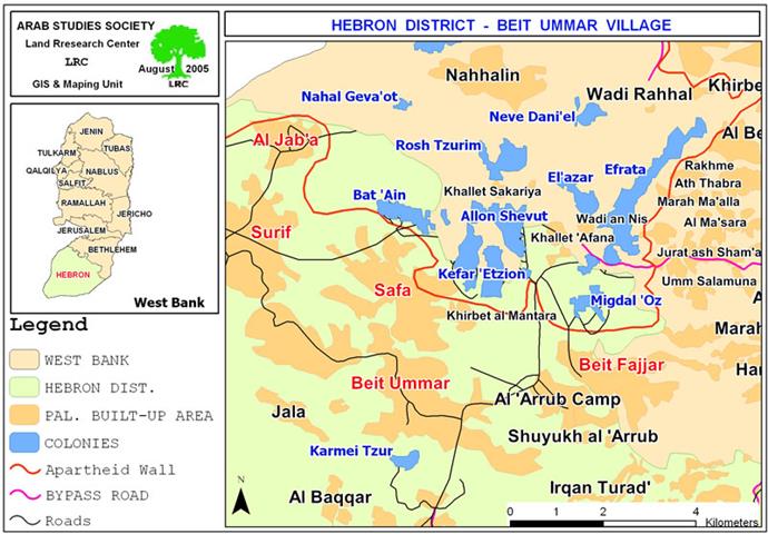
The Israeli army issued new military orders stipulating the confiscation of 578 dunums of lands from Beit Ummer, Safa, Surif towns in Hebron and Al Jab'a village in Bethlehem governorate for the construction of new sections of the Segregation Wall.
The orders were randomly thrown in the targeted lands and accidentally found by Palestinian farmers tending their lands. The new military orders are expected to confiscate and separate more than 4000 dunums of agricultural lands from these four towns and villages.
Beit Ummer and Safa:
The town of Beit Ummer and the village of Safa are located 12 km to the north of Hebron city, almost half way between Bethlehem and Hebron. They border the Gush Etzion settlement block from the south south. Their land are mostly cultivated with grape, peach and apple trees and are considered amongst the first agricultural towns in the district.
Bait Ummer has the population of 12000 inhabitants, while Safa, administratively linked to Beit Ummer municipality, and houses a total population of 1000 inhabitants.
Beit Ummer's total land area is 21284 dunums, of which 4300 dunums are designated for the built up area; while Safa village has a total land area of 10341 dunums, of which 3235 dunums are occupied by its built up area. See location of the four towns and villages and the Wall path
New military order:
The new military order concerning Beit Ummer and Safa lands carries the number of (T/133/05) and stipulates the confiscation of 466 dunums (4680 meter by 100 meter) in basin number 2 ( Jabel Abu Suda and Beit Zi'ta ) located at the southern edge of Gush Etzion settlement block.


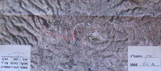
Photos 1, 2 & 3: a copy of the military order number T/133/05 and the attached map and photo), & : a copy of the military order number T/133/05 and the attached map and photo)
The targeted lands are owned by most main families in Beit Ummer and Safa, they are: Abu Aiyash, Alami, Aza'aqiq, Sabarna, Sulaibi, 'Idi, Ikhalyael and Abu Mariya.
Land owners said that the implementation of the order would besiege about 2000 dunums of lands between the current fence of the Gush Etzion bloc of settlements and the newly projected Wall, which, in turn, will dispossess and deprive many Palestinian families of their only source of livelihood, especially in this very fertile agricultural area.

( Photo 4: The vineyard valley located between Gush Etzion block of settlements ( (Photo courtesy of LRC )
More seriously, the construction of the Segregation Wall will cut the main artery road between Hebron and Jerusalem (road No. 60) which links the southern and northern parts of the West Bank together. The main southern entrance to Jerusalem will be Gush Etzion junction, and by doing so, the Israeli named Greater Jerusalem plan will be a reality. It is worth mentioning that this plan was disclosed during the 1990's. It expands from Beit Shemish in the West to the Dead Sea in the East and from Ramallah in the north to Gush Etzion in the south occupying an area of 600 km2 (almost 10% of the total area of the West Bank). Once established, the Palestinians will have to travel through a newly established road that goes by Taqu' village east of Bethlehem as an alternative to road number 60.


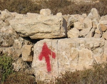
Photos 5,6, & 7: land marks for the Wall path near road No. 60 close to Gush Etzion Junction
(,, & : land marks for the Wall path near road No. 60 close to Gush Etzion Junction(Photos courtesy of LRC)
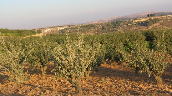
It is worth mentioning that the targeted areas are fully covered with grape, peach and apple fields as Beit Ummer and Safa are dominant agricultural towns in the district of Hebron. 90% of Beit Ummer and Safa citizens own agricultural lands and depend on agricultural products as their main source of income.

 c
c
Photos 8 & 9: vine yards and peach fields targeted by the Wall in Beit Ummer & : vine yards and peach fields targeted by the Wall in Beit Ummer
(Photo courtesy of LRC)
Surif and Al Jab'a:
Surif and Jab'a villages are located about 15 km to the northwest of Hebron city as front line villages whose lands are adjacent to the Armistice Line (Green Line). Surif's population is about 15000, and Al Jab'a's is about 600. Surif is affiliated to Hebron governorate while Al Jab'a village is affiliated to Bethlehem governorate.
Surif village has a total land area of 15337 dunums, out of which 5970 dunums are for the built up area. Al Jab'a village has a total land area of 10985 dunums, where 1019 dunums are occupied by the built up area.
New military order:
The second military order was served out to Palestinians of Surif and Al Jab'a villages. It carries the number of (T/ 131/05) and stipulates the confiscation of 113 dunums (1156 meters by 100 meters). The target lands are located in the areas of Qurnet Ghazal, Khalet Ghuneim, Wadi Abu Rish, Ein Al Biada, and Abu Tweim. They are owned by many families from Surif and Jab'a.
Palestinians of the two villages fear that once the Wall is built on these lands, another 2000 dunums are expected to be separated. This latest confiscation order was not the only one in Surif and Al Jab'a. Last year two other military orders were issued according to which hundreds of dunums of olive and grape groves were seized or separated behind the already established sections of the Wall to the west of the two villages ( for related information, see case studies from last year).
As a whole, the current Wall plan announced by the two aforementioned military orders against the four towns and villages are expected to confiscate or separate about 4000 dunums which is equal to 7% of the total land areas of these towns and villages.
Gush Etzion settlement blocks: Facts and figures:
The wall plan in this area aims at expanding and annexing the Gush Etzion settlement block to Jerusalem. Although the Gush Etzion block was built over West Bank lands, successive Israeli governments (mainly Likud and Labor) excluded the Gush Etzion seettlement block from any possible negotiations with the Palestinians. Now, with the advent of the Wall, the current Israeli government intends to annex it into Jerusalem proper.
The block contains 10 settlements built over lands confiscated from the surrounding Palestinian towns and villages of Beit Ummer, Beit Fajjar, Safa, Surif, Al Jab'a, Al Khader, Nahalin, Wadi Rahal, Jurat Asham'a and Um Salamona. The following are the 10 settlements by name, year of establishment and population:
|
No. |
Colony name |
Year of establishment |
Population in 2003 |
|
1 |
Migdal Oz |
1977 |
298 |
|
2 |
El'azar |
1975 |
882 |
|
3 |
Efrat |
1980 |
7037 |
|
4 |
Rosh Zurim |
1969 |
263 |
|
5 |
Allon Shevut |
1970 |
3146 |
|
6 |
Kfar Etzion |
1967 |
404 |
|
7 |
Kfar Etzion military camp |
1967 |
00 |
|
8 |
Bat 'Ain |
1992 |
Non Available |
|
9 |
Neve Daniyyel |
1982 |
1073 |
|
10 |
Nahal Geva'ot |
1984 |
Non Available |
|
Total |
|
13103 |
|
Source: Foundation for Middle East Peace
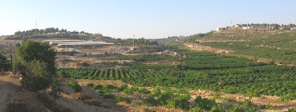
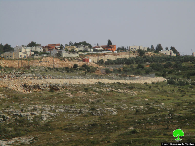
Photo 10: To the left is Kibutz Kfar Etzion and to the right is Kfar Etzion military camp.
Photo 11: The Bat 'Ian colony established by Sharon in 1992 is one of Gush Etzion settlements.
Photo courtesy of LRC
(Palestinian Land owners and farmers from the four locations have presented a quick objection to the Israeli military committee at Beit IL and they are determined to go ahead with their anti Wall actions.
Prepared by
The Land Research Center
LRC