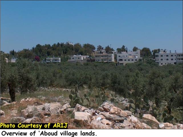
Bal'in and Saffa
Bal'in village is located kilometers north western of Ramallah city. According to PCBS 2004, the village houses a population of 1800 inhabitants and occupies a built- up area of 500 dunums, which comprises 12.5 % of the village's land area (4000 dunums). In 1948, the village lost more than 2000 dunums of its agricultural land for Israel, which was added to the lands inside the Armistice line (Green Line).
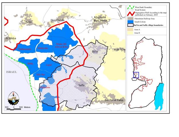
Whereby, Saffa village is located 18 kilometers to the west of Ramallah city. Its topographic relief is mountainous and agricultural, reaches up to 350 meters above the sea level. The village is situated on a Land area of 9700 dunums, whereby the built up area constitutes only 9.8 % (950 dunums) of the village's total area and houses a total population of 4138 inhabitants according to the Palestinian Central Bureau of Statistics. The village is bordered by Beit Sira and Kherbet Al Musbah from the south, Beit 'Ur Al Tahat from the southeast, and Bal'in and Kafr Ni'ma from the north east. See Map 1

A considerable number of villagers of both villages lost their Jobs as constructional workers inside Israel following the outbreak of the Second Intifada in September 2000. Those residents turned to work in agriculture as an alternative source of living. Now, almost 90 percent of the two villages' total populations depend on agriculture, mainly on olive and seasonal crops cultivation.
Israeli Settlements neighboring the two Palestinian villages:-
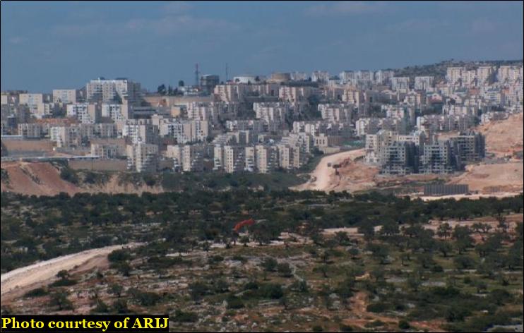
The two villages, Bal'in and Saffa, are bordered from the west by eight Israeli settlements that comprise the Modi'in Illit bloc within the Governorate of Ramallah and occupy an area of 10678 dunums. The block contains the settlements of: Kfar Rut, Shilta, Mattityahu, Makkabim, Hashmonaim, Lapid, Modi'in Illit (Qiryat Sefer) and Menora, See Map 1 . The settlements' details are listed in table 1 below: . The settlements' details are listed in table 1 below:
Table 1: Israeli settlements bordering Saffa and Bal'in villages(See Map 1 ) )
|
Settlement Name |
Date of establishment |
Area in (dunums) |
Estimated Population in 2002 |
|
|
1991 |
3973 |
26,400
|
||
|
Mattityahu |
1980 |
683 |
|
|
|
Hashmonaim |
1985 |
1050 |
2,200
|
|
|
Shilta |
1977 |
978 |
– |
|
|
Menora |
1998 |
759 |
|
|
|
Lapid |
1996 |
459 |
2,200
|
|
|
Kfar Rut |
1977 |
835 |
|
|
|
Makkabim |
1982 |
941 |
– |
|
|
|
Total |
|
10,678 |
|
ARIJ GIS Database 2005
The eight settlements were established on lands originally owned by Palestinians from Deir Qiddis, Khirbet Al Misbah, Ni'lin, Al Midya, Bi'lin, Saffa, Bir Ma'in, Al Burj village and Beit Sira. These villages lost much of their lands for building the settlements and later on for expanding them. Table 2 below details the lands' areas that were confiscated from those villages during the years 1977 and 1998 for settlement construction and expansion.
Table 2: Land area confiscated from Palestinian Villages for Settlement construction and expansion(See Map 1 )
|
Settlement Name |
Original Community Name |
Area confiscated from Communities (in dunum) |
|
Modin Illit (Qiryat Sefer) & Mattityahu |
Deir Qiddis |
2174 |
|
Kharbatha Al Misbah |
793 |
|
|
Modin Illit (Qiryat Sefer) & Mattityahu & Hashmonaim & Shilta & Menora |
Ni'lin |
1963 |
|
Hashmonaim |
Al Midya |
116 |
|
Shilta & Menora & Lapid & Kfar Rut |
Shilta |
2455 |
|
Modin Illit (Qiryat Sefer) & Menora & Menora |
Bal'in |
811 |
|
Menora & Lapid & Kfar Rut & Makkabim |
Saffa |
1149 |
|
Makkabim |
Beit Sira |
847 |
|
Makkabim |
Bir Ma'in |
367 |
|
Kfar Rut & Makkabim |
Al-Burj |
3 |
|
|
Total |
10,678 |
ARIJ GIS Database 2005
Table 2 shows that the total land area that was expropriated from the Palestinian villages for building Israeli settlements totaled 10678 dunums (10.678 km2). Out of the total, 1960 dunums (1.96 Km2) were taken from Bal'in and Saffa villages for the establishment of parts of Mod'in Illit (Kiryat Sefer), Menora, Lapid, Kfar Rut and Mekkabim settlements; whereby, the other Palestinian villages witnessed the loss of their lands for completing other settlements' constructions. , Menora, Lapid, Kfar Rut and Mekkabim settlements; whereby, the other Palestinian villages witnessed the loss of their lands for completing other settlements' constructions.
The Segregation Wall threatening the lands of Bal'in and Saffa Villages:-
On February 20, 2005, the Israeli Ministry of Defense issued a revised wall plan on its website stating a new wall route to be implemented in the West Bank, mainly in Middle and southern West Bank areas. The updated plan included the removal of a number of secondary walls in the northern areas, and a change in wall route in Bethlehem, Ramallah, Salfit and Hebron Governorates. stating a new wall route to be implemented in the West Bank, mainly in Middle and southern West Bank areas. The updated plan included the removal of a number of secondary walls in the northern areas, and a change in wall route in Bethlehem, Ramallah, Salfit and Hebron Governorates.
As for Ramallah Governorate, villages located west and northwest of the governorate were still affected by the Segregation Wall since the wall has not been drawn to the Armistice Line, but continued to confiscate agricultural lands and open spaces from the Palestinians.
Peaceful Demonstrations:-
We arrived to Bal'in village where a non-violent demonstration was about to take place. Villagers of Bal'in and Saffa went out to the street peacefully protesting against the thieving of their lands for constructing the Segregation Wall. Around 200 Palestinians, together with other Internationals and Israeli peace activists, showed up for the demonstration in Bal'in village and headed towards the construction's site, where hundreds of dunums of the village's lands are being razed for the wall constructions. The demonstrators chanted and waved with Palestinian posters and flags, which condemned the Israeli policies in the Palestinian Territory and their effects on the Palestinian community.
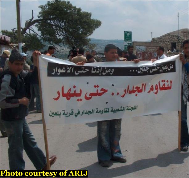
Photo 1: Palestinians chanting and waving Palestinian flags in Bal'in village protesting against Wall constructions
The moment the demonstrators approached the site, Israeli bulldozers, backed by Israeli forces, were uprooting Olive trees. Villagers tried peacefully to prevent the Bulldozers from uprooting the trees but they were met with the harshest actions as the Israeli forces started firing rubber bullets and tear gas bombs against the demonstrators in an attempt to disperse the demonstration.

Israeli soldiers gurding bulldozers while razing lands in Bal'in village.
The two villages like many other villages in the West Bank are threatened to lose their lands for wall construction. The Israeli bulldozers are currently working on the site were about 5000 dunums (5Km2) of the two villages' lands (Bal'in and Saffa) will become inaccessible to their original owners. Furthermore, the wall will stretch 6 kilometers from north to south along the western portions of the two villages. Table three below, details the land area that is going to be confiscated from Bal'in and Saffa villages.
Table 3: The two villages' land area and lands confiscated for the wall.
|
Village Name |
Area of Village Boundary |
Area isolated by the wall (dunums) |
Percentage of land isolated |
Wall length (in km) |
|
Bal'in |
4000 |
1964 |
49% |
2 |
|
Saffa |
9700 |
3038 |
31% |
4 |
|
Total |
13700 |
5002 |
37% |
6 |
ARIJ GIS Database 2005
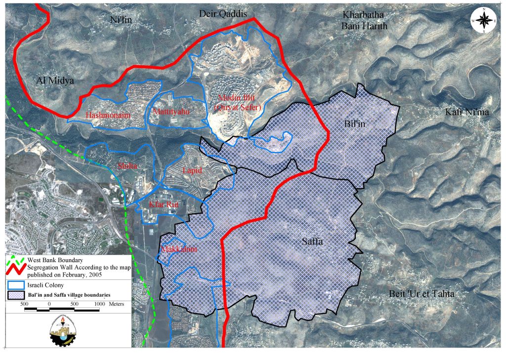
Map 2: Path of the Segregation Wall in Bal'in and Saffa villages.
As stated by Bal'in and Saffa village councils, the Palestinian lands threatened to become trapped by the Wall in Bal'in and Saffa, have already been drawn up to build a new settlement and expand the existing ones, mainly Modi'n city settlement (Modi'n bloc of settlements).Therefore, the construction of the Segregation wall has facilitated the integration of existing Israeli settlements.
It is worth emphasizing that residents of both villages are fully aware of the Israeli plan to connect the Israeli settlements together to reinforce the Modi'in block such as Qiryat Sefer (Modi'in Illit) with the nearby Mernora, Kfar Rut, Hashmonaim, Lapid, Mattiyahu, Shilta and Mukabbir settlements. with the nearby Mernora, Kfar Rut, Hashmonaim, Lapid, Mattiyahu, Shilta and Mukabbir settlements.
The Israeli forces did not mention whether they would require Palestinian residents of the two villages to obtain permits to enter and exit their lands, once the wall is constructed. Even if the Israeli occupation forces require them to apply for permits, the procedure to get a permit would be long, tiresome and often impossible for Palestinian families since the permit system used by IOF (Israeli Occupation Forces) is an institutionalized method of discrimination and dispossession as in the case of cities and villages in northern West Bank areas.
Israeli plans in Bal'in and Saffa Villages
In another incident, the Israeli occupation Forces showed the residents of Saffa village new maps for the area and informed them of their intention to build a new settlement named 'Mattiyahu east' on a 60 dunums piece of land cultivated with Olive trees and located in between Modi'n Illit (Qiryat Sefer) and Lapid settlements. The settlement is planned to have 1500 new housing units for the Israeli settlers.
The Segregation Wall and International Laws:-
The construction of the Segregation Wall is less for security than a step to expand Israel's borders and settlements. Israel, by constructing the Segregation Wall violates many of International Humanitarian laws, specifically The Hague Regulations of 1907 and the Fourth Geneva Convention of 1949, which state the following:
- The Hague Regulations expressly forbids an occupying power 'to destroy or seize the enemy's property, unless such destruction or seizure be imperatively demanded by the necessities of war' (Article 23).
- The Fourth Geneva Convention, the primary document of international law governing instances of military occupation, states in Article 49 that: 'The occupying power shall not deport or transfer parts of its own population into the territories it occupies.'
- Article 53 of the Fourth Geneva Convention is also clear that: 'any destruction by the Occupying Power of real or personal property belonging individually or collectively to private persons, or to the State, or to other public authorities, or to social or cooperative organizations, is prohibited, except where such destruction is rendered absolutely necessary by military operations.'
- The appropriation and destruction of Palestinian land is an especially serious violation of the Fourth Geneva Convention, Article 147 of which clearly prohibits, ''extensive destruction and appropriation of property, not justified by military necessity and carried out unlawfully and wantonly.'' Violations of Articles of the Fourth Geneva Convention constitute grave breaches of the Convention and should be prosecuted as War Crimes.
References
1. ARIJ GIS Database 2005
2. Bal'in Village Council – 2005.
3. Saffa Village Council – 2005.
4. The Israeli Ministry of Defense website – updated wall plan February 20, 2005.
5. The Hague Regulations of 1907 and the Fourth Geneva Convention of 1949.
6. Palestinian State Information Service.
7. Oslo II agreement – September 28, 1995 : Article XXXI, point seven.
8. ARIJ Fieldwork to Bal'in and Saffa Villages.
9. Palestinian Central Bureau of Statistics.
Prepared by:
The Applied Research Institute – Jerusalem