The Village of Ni'lin is located 35 kilometers to the northwest of Ramallah city, approximately 2 kilometers from the Armistice line (Green line). The village is among the northwestern Ramallah villages and is 20 minutes far from Ramallah City center. Ni'lin is nestled between two villages, Deir Qiddis from the east and Al Midya from the southwest, while Qibya is located to its north and the Modi'in Ellit settlement block is located to its south. Ni'lin is known for its wonderful overlooking view of the surrounding open spaces and agricultural lands of the neighboring Palestinian villages. This rich agricultural village is a home to over 4,800 inhabitants and a variety of social facilities.
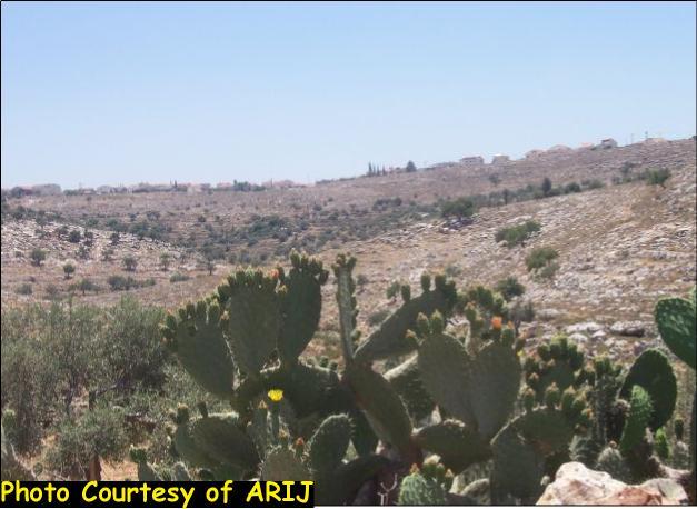
Much of the land surrounding Ni'lin village is rooted deeply in agriculture exemplified in Olive and Cactus trees, in addition to crop production.
The name Ni'lin came from a Roman word ' 'Allin ' which means the 'High Hilltop' (according to Ni'lin village council.) The village's location reaches up to 260 meters above the see level. It occupies a total area of 14,800 dunums (14.8 Km2), of which 584 dunums (0.584 Km2) are for the built-up area. See Table 1 below
|
Table 1: Land Use classifications in Ni'lin village, 2005. |
||
|
Land Type |
Area in dunums |
Percent from total village boundary area |
|
Agricultural land |
5,507 |
37% |
|
Jewish settlements |
1,337 |
9% |
|
Palestinian built-up area |
584 |
4% |
|
Open Spaces |
5.569 |
38% |
|
Forests |
1.796 |
12% |
|
Total |
14,793 |
100% |
Ni'lin's Population:-
In the year 1922, Ni'lin's population was 1160 inhabitants, and increased to 1420 inhabitants in 1945. Following the 1967 war, the village was exposed to the Israeli aggression that caused the displacement of many of its residents to nearby areas, which brought the population down to 1200 inhabitants. However, the community grew throughout the years to house approximately 2100 inhabitants in 1978 and finally, 4864 inhabitants in 2003 (PCBS statistics 2003 and State Information Services.) Table 2 below details the increase of number of inhabitants throughout the years in Ni'lin village.
|
Table 2; The total population in Ni'lin village during (1922 – 2005). |
|
|
Year |
Population |
|
1922 |
1160 |
|
1945 |
1420 |
|
1967 |
1200 |
|
1987 |
2100 |
|
2004 |
4864 |
Source: State Information Service
Israel's Settlement Policy:-
Following the 1967 war, Israel has taken control of thousands of dunums of Palestinian lands throughout the West Bank with the primary goal to establish Israeli settlements and to encourage Israeli settlers to come and live in them. To do so, Israel has pursued three main policies through which it could seize the land, of which the requisition for military necessities, the declaration of land as absentee property and the confiscation of land for public needs.
The establishment of Israeli settlements breaches various provisions of International law to which Israel is bound to; the Hague Convention on the Laws and Customs of War on Land, and Hague Regulations of 1907, and the Fourth Geneva Convention Relative to Civilian Persons in Time of War, of 1949, see appendix 1. Despite the blatant breach of all International laws, settlements continued to expand on the expanse of Palestinian land.
The case of the village of Ni'iln, is the same as many other Palestinian villages and cities that were exposed to the Israeli colonial attack which included the confiscation of lands at favor of building Israeli settlements.
During the eighties, the village of Ni'lin lost considerable areas of its lands for constructing the first two settlements on its lands, Mattityahu in 1982 and Hashmonaim in 1982. The construction of the two settlements caused the confiscation of about 1,600 dunums (1.6 Km2) of the lands of Ni'lin.
Later in 1993, Israel announced the construction of a new settlement called Mod'in Illit (Qiryat Sefer)- on lands mostly confiscated from Ni'lin village which constituted about 300 dunums in addition to lands confiscated form the nearby Palestinian Villages such as Bal'in, Dear Qiddis and Kherbit Al Musbah.
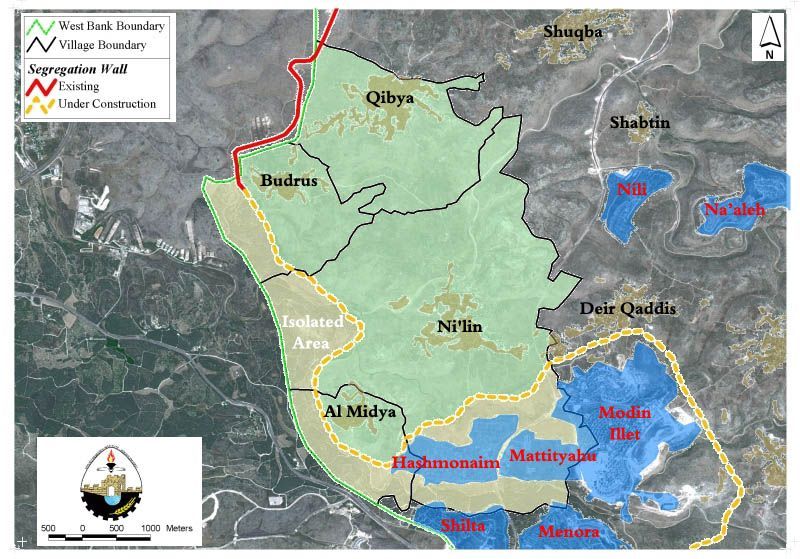
Today, the village is bordered by those three Illegal settlements from the south and southeast as shown in the table 3 and map 1 below.
|
Table 3; The illegal Israeli settlements in Ni'lin village 2005. |
||||||
| Settlement Name |
Date Founded |
Population (Year 2002) |
Total area August 2004 (in dunums) |
Occupies from Ni'lin village boundary |
location from Ni'lin Village | |
|
1985 |
2,100 |
1050 |
921 |
1km to the south |
||
| Modin Illit (Qiryat Sefer) |
1993 |
24,300 |
3973 |
300 |
1km to the southeast | |
| Mattityahu |
1981 |
1,365 |
683 |
700 |
1.3km to the southeast |
|
| Total |
|
27,765 |
5706 |
1921 |
|
|
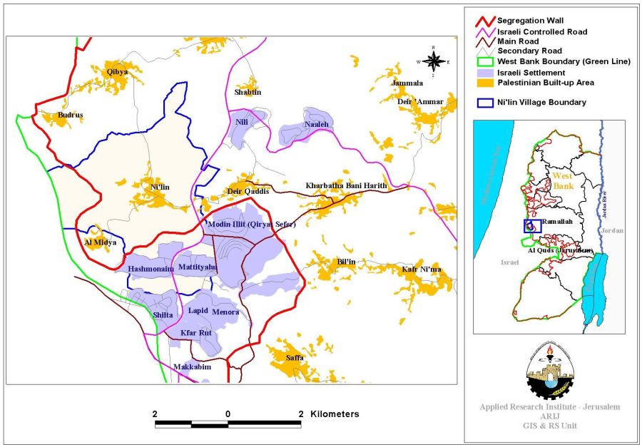
The route of the Segregation Wall in Ni'lin village:-
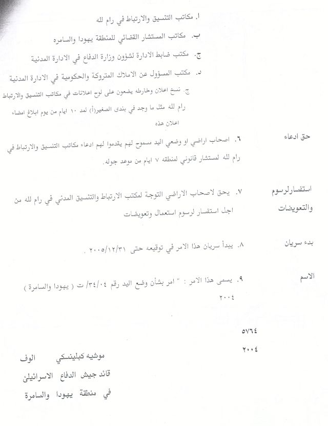
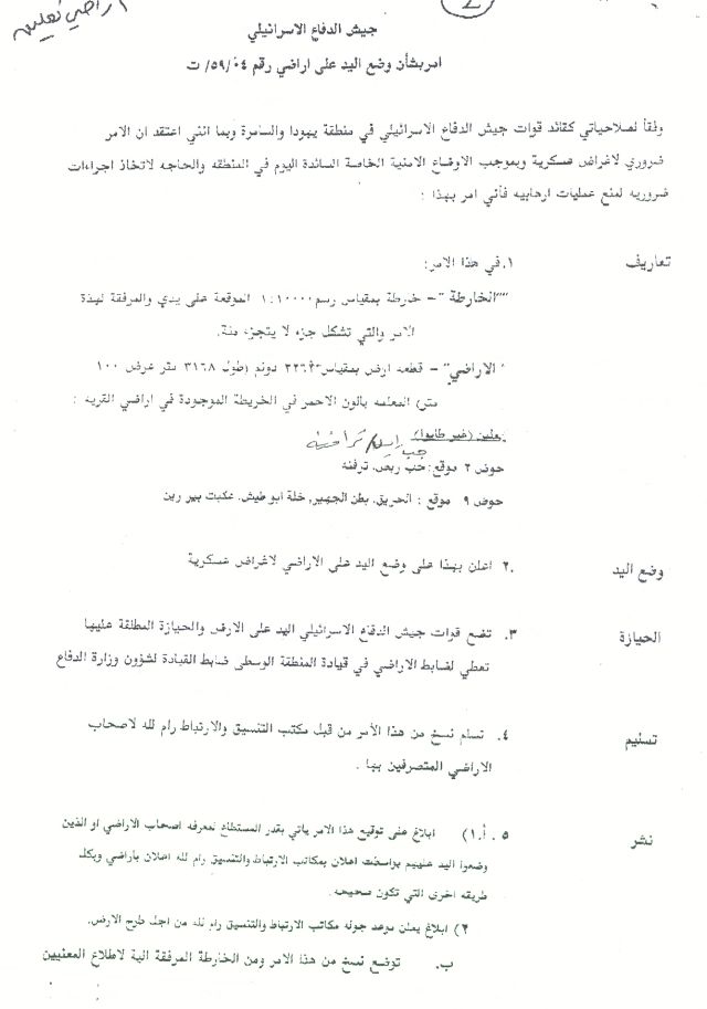
On December 13, 2003, the Israeli forces handed out residents of Ni'lin a military orders number (114/03/T Judea & Samaria 2003) stating the seizure of 590 dunums (0.59 Km2) of their lands for the construction of the Israeli Segregation Wall. See copy of military order

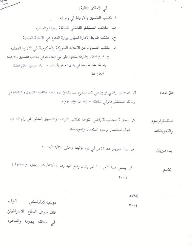
Copy of military order (114/03/T Judea & Samaria 2003)
Villagers of Ni'lin filed their suit to the Israeli High Court to stop the Israeli attack on the village, since it cuts them off from their agricultural lands and grazing areas. The Israeli bulldozers rushed to the place and started uprooting trees in the village to commence the construction of the wall but were met by nonviolent protests led by Palestinians in the village.
During the second quarter of last year (April and May of Year 2004) , two other military orders numbered (34/04/T & 59/04/T Judea & Samaria 2004) were served to the villagers of Ni'lin stating the confiscation of a total of 2737.5 dunums from the village's lands for constructing the Segregation Wall. The villagers for the second time brought their case to the Israeli High Court, which later passed an injunction to halt the work in their lands. The work was halted until further notice. (See military orders numbered (34/04/T & 59/04/T)

 j
j
In November 8, 2004, villagers of Ni'lin were surprised to receive another military order numbered (83/04/T Judea & Samaria 2004) that stated the confiscation of 177.9 dunums (0.177 Km2) from the village's lands for the Segregation Wall construction. The area stated in latter military order (83/04/T ) didn't include the actual area that was slated for segregated by the wall but only delineated the path of the wall.
Ni'lin village went through many changes as regard to the Segregation Wall path. The first wall map incepted by the ministry of defense in June 2002 showed that Ni'lin village along with a number of Palestinian villages (Deir Qiddis, Shibteen, Budrus, Al Qibya, Shuqba and Rantis) were about to become Segregated in one Ghetto and disconnected from Ramallah city, the main center for all west and northwest Ramallah villages. The map included a main wall to come along the western lands of the aforementioned villages and another depth wall to come along the eastern lands of the villages. See map of the Segregation Wall of June 2002.
On February 20, 2005, the Israeli Ministry of Defense issued a revised wall map that stated a change in wall route to be implemented in middle and southern West Bank Governorates, mainly Ramallah, Bethlehem and Hebron.
According to an analysis conducted by the GIS unit (Geographical Information System) at the Applied Research Institute, the new wall map showed that the village of Ni'lin will no longer be segregated in one Ghetto (along with the other Palestinian villages mentioned earlier) but rather will lose much of its lands as the wall will stretch a length of 5.5 km along the western mountains of the village and isolate about 5200 dunums (5.2 Km2) of its agricultural lands.
Today, the Wall is under construction in the western parts of the village and only few sections are left for the wall to be completed. Table 4 below details the lands that are going to be segregated by the wall in the Village: –
|
Table four (II); Land Use/ Land Cover west of the Segregation Wall path – Ni'lin village, 2005 (Areas Segregated by the Wall). |
Table four (III); Land Use/ Land Cover east of the Segregation Wall – Ni'lin village 2005. (Lands left for the village). |
|
|||
|
Type land |
Area/ Kilometers2 |
Percent from the total village boundary area |
|
Percent from the total village boundary area |
Total |
|
Arable land |
0.856 |
6% |
4.651 |
31% |
5.507 |
|
Jewish settlements |
1.337 |
9% |
0 |
0% |
1.337 |
|
Palestinian built-up area |
0 |
0% |
0.584 |
4% |
0.584 |
|
Open Spaces and forests |
2.996 |
20% |
4.369 |
30% |
7.365 |
|
Total |
5.189 |
35% |
9.604 |
65% |
14.793 |
Conclusion:-
The systematic nature of Israel's occupation policies (including the Segregation Wall) submits it to a further violation to the Human Rights and international law and comprises a crime of apartheid according to the International Convention on the Suppression and Punishment of the Crime of Apartheid (1973). Moreover, the crime of Apartheid comprises a 'crime against humanity' and 'a serious threat to international peace and security.
It is a flagrant violation of international humanitarian law, specifically The Hague Regulations of 1907 and the Fourth Geneva Convention of 1949:
-
The Hague Regulations expressly forbids an occupying power 'to destroy or seize the enemy's property, unless such destruction or seizure be imperatively demanded by the necessities of war' (Article 23).
-
The Fourth Geneva Convention, Article 49.
-
Article 53 of the Fourth Geneva Convention is also clear that: 'any destruction by the Occupying Power of real or personal property belonging individually or collectively to private persons, or to the State, or to other public authorities, or to social or cooperative organizations, is prohibited, except where such destruction is rendered absolutely necessary by military operations.'
-
The appropriation and destruction of Palestinian land is an especially serious violation of the Fourth Geneva Convention, Article 147 of which clearly prohibits, ''extensive destruction and appropriation of property, not justified by military necessity and carried out unlawfully and wantonly.'' Violations of Articles of the Fourth Geneva Convention constitute grave breaches of the Convention and should be prosecuted as War Crimes.
Appendix 1:-
-
Article 49 of the Fourth Geneva Convention relative to the Protection of Civilian Persons in Time of War, August 12, 1949, 6 UST 3516, paragraph 6: The Occupying Power shall not deport or transfer parts of its own civilian population into the territory it occupies.
-
Article 46 of the Hague Convention prohibits the confiscation of private property in occupied territory. The confiscation of land by the Israeli government for settlement construction is in violation of this article. (Laws and Customs of War on Land (Hague II); July 29, 1899).
-
Article 55 of the Hague Convention stipulates that 'the occupying state shall be regarded only as administrator and usufructuary of public buildings, real estate, forests, and agricultural estates belonging to the hostile State, and situated in the occupied country. It must safeguard the capital of these properties, and administer them in accordance with the rules of usufruct.' In other words, the occupying power cannot take over or use territories or private properties in the occupied territories to serve the interests of its civilian population. (Laws and Customs of War on Land (Hague II); July 29, 1899).
-
The Rome Statute of the International Criminal Court (1998) defines 'the transfer directly or indirectly by the Occupying power of parts of its own civilian population into the territory it occupies' as a War Crime indictable by the International Criminal Court. (Article 7, Crimes Against Humanity).
-
UN Security Council Resolution 465 of 1980 Determines that all measures taken by Israel to change the physical character, demographic composition, institutional structure or status of the Palestinian and other Arab territories occupied since 1967, including Jerusalem, or any part thereof, have no legal validity and that Israel's policy and practices of settling parts of its population and new immigrants in those territories constitute a flagrant violation of the Fourth Geneva Convention relative to the Protection of Civilian Persons in Time of War and also constitute a serious obstruction to achieving a comprehensive, just and lasting peace in the Middle East.
References:-
1. Geographical Information System unit -ARIJ Database, 2005.
2. Palestinian Center Bureau of Statistics (PCBS) 2005.
3. Ni'lin village Council.
4. State Information Service 2005.
5. The Hague Regulations of 1907.
6. TheFourth Geneva Convention of 1949.
7. United Nations Information System on the Question of Palestine -UN Resolutions.
Prepared by:
The Applied Research Institute – Jerusalem