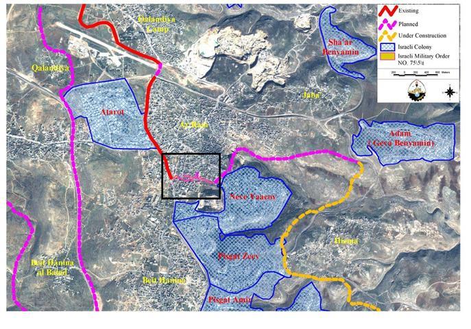
On March 8, 2005, Israeli occupying forces served the towns of Dahiyet Al Barid and Al Ram a new military order numbered (05/57/T Judea & Samaria 2005) stating the seizure of 26.2 dunums of land and making a way for a new section of the Segregation Wall to be constructed in the area. The Wall will break through the residential houses cutting between the close neighbors and separating the house from its garden. Accordingly, Dahiet al Barid neighborhood will be split into two totally separated parts. A Verbatim translation of the military order is added to Appendix 1. See map of military order below:
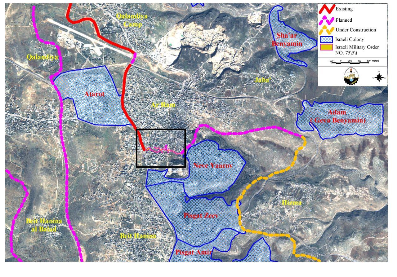
The part that falls in the Jerusalem side of the Wall contains three monasteries, two schools, the World Bank and USAID Offices in addition to other local institutions and clubs. These schools and institutions will no longer be accessible to the Palestinian people living in the West Bank. The area that falls south of the area specifies in the military order in Dahiet Al Barid will be entrapped between the Wall and the Israeli unilaterally declared municipal boundary, thus further areas of the West Bank will be seized. The status of properties and the people living there and holding the West Bank IDs is still not known. See a cross-sectional area of the wall in Ar Ram area.

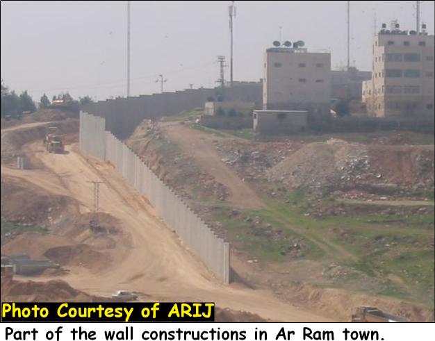
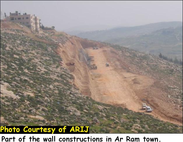
Ar Ram town is one of the Palestinian towns that are currently undergoing wall constructions and witnessing destruction. The 6-8 meters high concrete wall is now winding its way in and around the town, strangulating and dividing Ar Ram into parts. The Segregation Wall section that stretches along the main road from Jerusalem to Qalandyia checkpoint and Ramallah beyond is already done, except for few concrete blocks in Al Ram junction. The section of the Segregation Wall that stretches from the south western part of Al Ram grabbing what is left from the village's open space and placing them at the other side of the wall (close to the illegal settlement of Neve Ya'acov) meets with the Wall that surrounds Hizma village from the eastern side. This section of the Segregation Wall is currently under construction and expected to be shortly done. See pictures of ongoing wall constructions in Ar Ram area.
Another military order, number 04/100/T was issued on December 2004 from the Israeli Occupying Forces that confiscates 49.3 dunoms from Al Ram lands, claming its necessity for 39;military39; reasons. The lands are located lose to Qalandiya junction north of road 45, see map 2.
The land owners were given seven days to appeal this order, and were asked to go to the District Coordination Office (DCO) in Ramallah to ask about their rights in compensation or usage fees. However the Israeli occupying forces have launched massive land razing in the area. It is note mentioning that Qalandiya checkpoint is just few meters way from the aforementioned site. From the enormous amount of Israeli work in the site, it is expected that there will be arrangements to make Qalandiya checkpoint a terminal.
Ar Ram town is considered as a commercial center for the neighboring Palestinian towns and villages of Beir Nabala, Al Jib, Al Judera, Beit Hanina and villages northwest Jerusalem city that have come to partially depend on Al Ram town for providing them with most needed services and goods at affordable prices than in Jerusalem city. Now, with the wall being constructed in the area, a more promising catastrophic economic situation.
An Updated wall plan by the 39;Israeli Ministry of Defence39;
The Israeli ministry of defence issued on February 20, 2005, an updated plan of the Segregation Wall. The wall according to the map will encircle the town from its western, southern and south eastern directions and entrap its residents within the boundaries of the West Bank, while denying them access to Jerusalem. Around 60 thousand Palestinians living in, near and around the town share a similar fate as the Israeli forces, increasingly, keep issuing military orders to seize additional lands for constructing the Segregation wall.
The new military order (numbered (05/57/T Judea & Samaria 2005) served to residents of Dahiyet Al Barid shows that a new wall section, about 1.3 km long, is planned to be constructed on lands south of Ar Ram city. This planned section, as shown in the map, is supposed to connect the existing section of the Wall (west of Ar Ram – in red) with the constructed section (southeast of Ar Ram- in pink); eventually separating Ar Ram from Beit Hanina.
Conclusion:
Palestinians continue to lose their lands and properties for Wall constructions and settlement expansions. The Israeli Government insists that the wall is a necessary and temporary for security measures while it violently cuts into the West Bank and Gaza Strip.
The wall is blatant violation of International law, specifically The Hague Regulations of 1907 and the Fourth Geneva Convention of 1949 which state:
-
The Hague Regulations expressly forbids an occupying power 39;to destroy or seize the enemy39;s property, unless such destruction or seizure be imperatively demanded by the necessities of war39; (Article 23).
-
Article 53 of the Fourth Geneva Convention is also clear that:39;any destruction by the Occupying Power of real or personal property belonging individually or collectively to private persons, or to the State, or to other public authorities, or to social or cooperative organizations, is prohibited, except where such destruction is rendered absolutely necessary by military operations39;
The appropriation and destruction of Palestinian land is also a breach of the Fourth Geneva Convention, Article 147 which clearly prohibits,39;39;extensive destruction and appropriation of property, not justified by military necessity and carried out unlawfully and wantonly.39;39;
Appendix 1:
|
Israel Defense Forces Order to Seize lands n0 05/57/T According to my authorities as a Military Chief Commander in the Region of Judea and Samaria, and as I believe that it is imperative for military reasons due to the special security situation in the region, I order the following: 1- The 39;Map39; signed in scale 1: 5000 and attached to the order is an essential part of this order. The 39;Lands39; : An area of land which is 26.2 dunums, marked in red in the map:
2- I announce by that the above mentioned lands are seized for military reasons. 3- The IDF seize the lands and have an absolute control over it that is given to the officer of the central command officer of lands who is responsible in the ministry of defense. 4- These copies are to be given by the District Co-ordination Office 39;The DCO39; of Jerusalem to the owners of land. 5- Copies are found with maps for those who are interested in the following places :
6- The owners of land have the right to go to the DCO in Jerusalem in order to get more information about their right of land use expenses and compensation. 7- The Validity of this order starts at the date signed till 31/12/2005. 8– The name of this order is: 'Order to seize lands n0 05/57/T (Judea & Samaria) 2005.
Yai39;r Neveah |
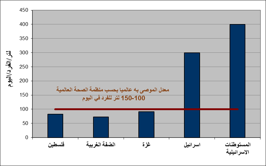
[1] Palestinian Central Bureau of Statistics 2003 and Jerusalem statistical Year Book 2003
Prepared by:
The Applied Research Institute – Jerusalem