The Village of Beit 'Anan
Beit 'Anan is a small Palestinian village located in the northwestern part of Jerusalem. It is home to 4,386 Palestinians according to Palestinian Central Bureau of Statistics (PCBS, 2004) whose daily bread is primarily dependant on agriculture, much like other villages in the West Bank. Administratively, the village stands on an area of 10,074 dunums (10.1 km2), out of which 595 dunums (0.595 km2) constitute the built-up area.
Beit 'Anan and the Segregation Wall
The Israeli official attack on the lands of Beit 'Anan for the purpose of constructing the Segregation Wall started in July 17, 2003, when the Israeli Occupation forces served residents of Beit 'Anan military orders to confiscate their lands for constructing the Segregation Wall.
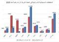
Later, in December 2004, the Israeli Occupation Forces served Beit 'Anan Residents new military order numbered 03/103/T Judea & Samaria 2003 which stated the confiscation of 607 dunums (0.6 km2) of the village's lands. The military order also included an area called Jabal Al Muqattam (Al Muqattam Mountain) which is located in northwestern part of the village of Beit 'Anan and is 2450 meters (2.5 km) away from the Armistice Line. This mountain links the village with four other Palestinian villages housing more than 20,000 inhabitants. It is considered a private property owned by more than 300 people from Beit 'Anan who have documents that prove their ownership of the mountain and the lands adjacent to it.
Beit 'Anan residents depend mostly on agriculture for their living, they used to plant the land with different kinds of vegetables and fruitful trees, mostly Olives and Grapes which constitute about 90% of the village's cultivation. Therefore, residents of Beit 'Anan village objected the route of the wall and filed a suit to the Israeli high court in an attempt to change the route that consumes most of their agricultural lands.
The Israeli High Court issued its ruling on 29 June 2004 (just few days before the International Court of Justice ruling in Hague) to reroute 30 km of the Wall in nine Palestinian villages northwest of Jerusalem city including Beit 'Anan. Months later, specifically in November 2004, residents of Beit 'Anan were served another military order number (n0 04/87/T) that stated the change in the Wall route.The military order, however showed that A longer section of the Segregation Wall will be built on the lands of The military order, however showed that A longer section of the Segregation Wall will be built on the lands of Beit 'Anan, a full 1,700 meters (1.7 km) away from the Green Line; and will cut within a distance of 1,000 meters (1 km) away from the village's built up area. The military order threatens to appropriate 2,720 dunums (2.7 km2) of Beit 'Anan lands (roughly 27% of the total). See map One:

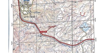
Map 3: Old and new route of the Wall in villages located northwest Ramallah city
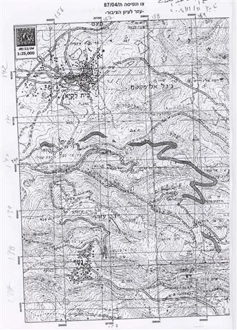
Israeli Military Orders (number 04/87/T Judea & Samaria 2004)
On the 20th of February 2005, the Israeli ministry of Defense released an 'updated' map of the path of the Segregation Wall in the West Bank. The Wall, according to the map, will confiscate 2,385 dunums (2.4 km2) of Beit 'Anan 's land. The map is no more than a cosmetic change to the original route of the Segregation Wall as the village is still facing the threat of isolation and confiscation of large portions of its lands.
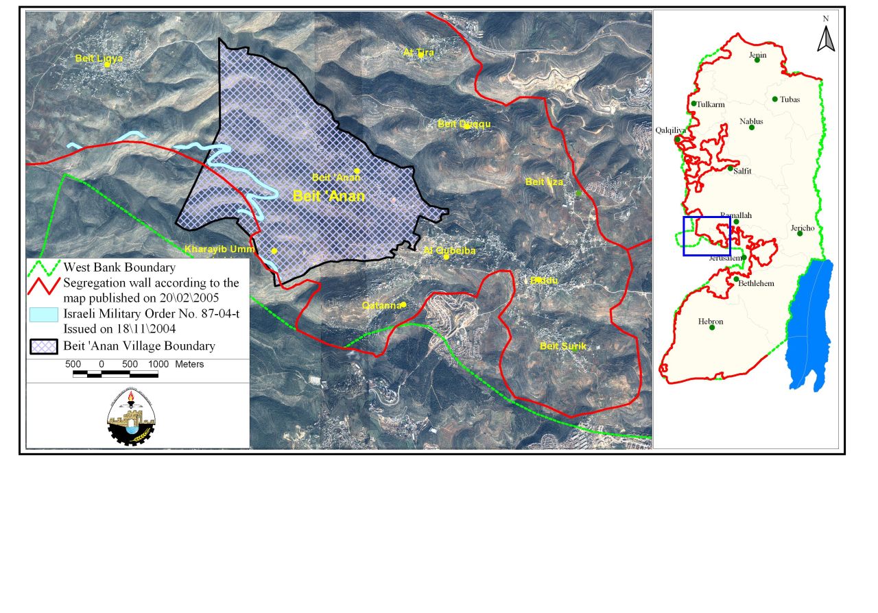
Map Two: The Segregation Wall in Beit 'Anan
Conclusion:
The systematic nature of Israel's occupation policies (including the Segregation Wall) submits it to a further violation to the Human Rights and international law. Israel's military occupation and the accompanying policies it enforces in the Occupied Palestinian Territory (OPT) comprise a crime of apartheid according to the International Convention on the Suppression and Punishment of the Crime of Apartheid (1973). The Convention defines apartheid as: 'the imposition of various legislative measures on different racial groups while injuring the rights of one. Moreover, the crime of Apartheid comprises a 'crime against humanity' and 'a serious threat to international peace and security.
It is also a flagrant violation of international humanitarian law, specifically The Hague Regulations of 1907 and the Fourth Geneva Convention of 1949:
-
The Hague Regulations expressly forbids an occupying power 'to destroy or seize the enemy's property, unless such destruction or seizure be imperatively demanded by the necessities of war' (Article 23).
-
The Fourth Geneva Convention, the primary document of international law governing instances of military occupation, states in Article 49 that: 'The occupying power shall not deport or transfer parts of its own population into the territories it occupies.'
-
Article 53 of the Fourth Geneva Convention is also clear that: 'any destruction by the Occupying Power of real or personal property belonging individually or collectively to private persons, or to the State, or to other public authorities, or to social or cooperative organizations, is prohibited, except where such destruction is rendered absolutely necessary by military operations.'
-
The appropriation and destruction of Palestinian land is an especially serious violation of the Fourth Geneva Convention, Article 147 of which clearly prohibits, ''extensive destruction and appropriation of property, not justified by military necessity and carried out unlawfully and wantonly.'' Violations of Articles of the Fourth Geneva Convention constitute grave breaches of the Convention and should be prosecuted as War Crimes.
References:-
-
ARIJ Geographical Information Systems (GIS) Database, 2005
-
Israel ratified the Convention in 1979.
-
The International Convention on the Suppression and Punishment of the Crime of Apartheid (1973), Article II, Sections (c) and (d). See also the Convention on the Elimination of Racial Discrimination, Articles 2, 3 and 5.
Prepared by:
The Applied Research Institute – Jerusalem


