Last week, Israeli occupying forces began to clear land and construct sections of the Segregation Wall in the village of Hizma on the outskirts of East Jerusalem. The Wall is cutting through Hizma39;s traditional territory and appropriating 4,318 dunums (4.3 km2) of Palestinian land to the Israeli occupation authorities and illegal Israeli settlements in the area.
Construction is ongoing west of Hizma, along the main road used by Palestinian traffic, traveling between the northern cantons of the West Bank to the southern sections of the West Bank. The village, however, is also hemmed in by two illegal Israeli settlements Anatot (est. 1981), to its east, and Pisgat Ze39;ev (est. 1985), to its west. These settlements have appropriated an additional 2,000 dunums (2 km2) of Hizma39;s lands and control additional lands east of the village. As a result of Israel39;s new construction, Hizma is now trapped between the Wall and the settlements.
The Segregation Wall in Hizma
Israeli occupying forces began clearing land for construction of the Segregation Wall in Hizma in December, 2004. On March 3, 2005, Israeli occupying forces served two additional military orders to the village. The military orders (numbered 5/34/T and 5/36/T) specified that approximately 9.2 dunums of Hizma39;s land would be confiscated for construction of the Wall. The orders also confiscated 12 dunums from the neighboring localities of Jaba'a and Al Ram (See Appendix for an example of Israeli military orders served to Hizma).
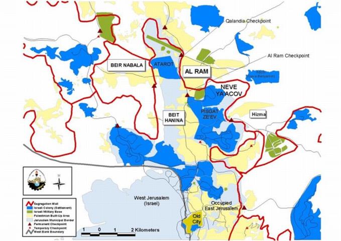
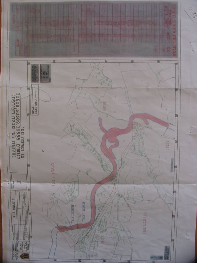
Hizma is a town of 6,000 people, located on the outskirts of northeast Jerusalem. The built-up area of the town is 870 dunums (.87 km2), but Hizma39;s historical territory comprises 10,390 dunums (10.4 km2), most of which is agricultural land. The Segregation Wall will stretch for 5 km along the Western portions of the village lands. When complete, the Wall will isolate 4,318 dunums (4.3 km2) of land from the Hizma, Al Ram and39;Anata territories. The lands will be de-facto annexed to the illegal Israeli settlements of Neve Ya39;acov (est. 1972) and Pisgat Ze39;ev (est. 1985), which dominate the hills west of the village (see Map One, Photos One and Two). and )., Photos and ).

Map One: Hizma in a Regional Context

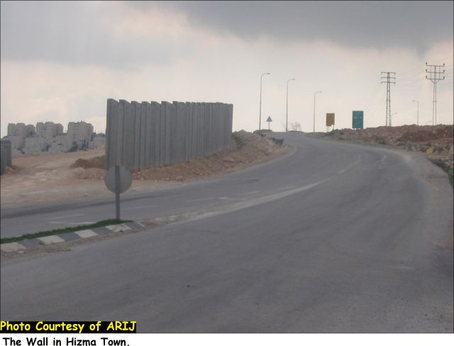
Photos One and Two: Wall Construction in Hizma
Like many Palestinian villages in the West bank, Hizma is heavily dependent on agriculture and grazing. The agricultural sector comprises 30% of the village39;s economy, while shepherding makes up roughly 25%. As a result, Hizma's residents are highly dependent upon the lands surrounding their village. More than 30% of Hizma39;s total agricultural lands are being isolated by the Wall. Village residents will be unable to access these lands and tend to lose their crops in the area. Vast quantities of open grasslands used for grazing sheep and goats are also being rapidly appropriated by the Wall, drastically reducing the amount of land available to Hizma's shepherds. As a result, the Wall will have devastating affects for Hizma39;s residents.
Illegal Israeli Settlements in Hizma
The Segregation Wall is part of Israel39;s colonization policy in the Occupied Palestinian Territory (OPT). The goal of the Wall is to appropriate as much land as possible for Israeli settlements and extend Israeli military control over additional Palestinian areas. The intricate relation between the Segregation Wall and Israel39;s settlement policy is evident in Hizma.
There are four illegal Israeli settlements built on Hizma39;s traditional territory. The large urban settlements of Neve Ya'acov (est. 1972) and Pisgat Ze'ev (est. 1985) dominate the hills west of Hizma. The Wall is now annexing additional open spaces to these large settlements. On its eastern flank, Hizma is hemmed in by the settlements of Adam (Geva Benyamin), to the northeast, and Anatot (Almon .. est. 1981), to the southeast. There is also an Israeli outpost settlement attached to the Adam settlement and controlling additional Palestinian lands in the eastern Al Kobah area of Hizma.
The settlements have a combined population of more than 61,000 Jewish settlers and cover an area of 4,760 dunums (4.7km2). The Segregation Wall is appropriating large open areas below the settlements of Pisgat Ze39;ev and Neve Ya39;acov both west of the Wall39;s path, resulting in the de-facto expansion of the settlements over an additional 3,728 dunums (3.7 km2) of Palestinian land belonging to the towns of Hizma, Al Ram, Shu39;fat and 39;Anata (see Photo Three). The settlements of Anatot (Almon) and Adam (Geva Benyamin), however, rest east of the Wall39;s path. These two settlements encroach upon Hizma39;s land from the east.
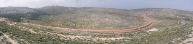
Photo Three: Path of the Wall in Hizma
Ongoing construction of the Segregation Wall west of Hizma appropriates large areas of open space for settlement expansion. The illegal Israeli settlement of Neve Ya'acov is on the hill behind.
Anatot (Almon) and Adam (Geva Benyamin) have appropriated large portions of Hizma39;s land for the exclusive use of the settlers. The hillsides leading from the settlements down to Hizma comprise 2,582 dunums (2.58 km2) and are controlled by Israeli occupying forces. Palestinian residents of Hizma are not allowed to cultivate the lands or graze their livestock on the hills. Palestinians caught on the land are fined and/or detained by Israeli occupying forces protecting the settlements. The settlers have also begun to cultivate the Palestinian land for their own use, planting and harvesting crops on the hillsides (see Map Two).
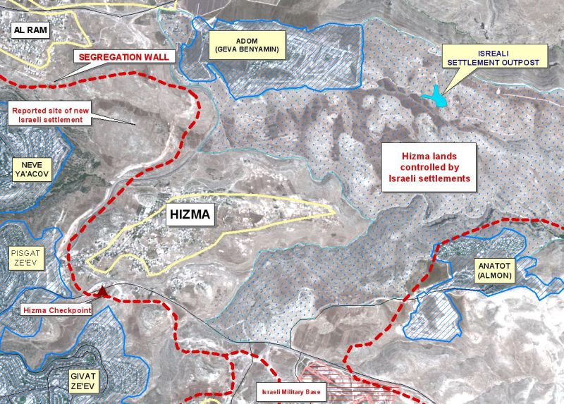
Map Two: Israeli Colonization in Hizma
The settlements lying to the east of Hizma ((Almon (Anatot)) continue to expand and push against the Palestinian village. The new settlement outpost (seen in map 2) built by Israeli settlers on land in the Al Kobah area of Hizma, is one feature of this colonization program. According to Hizma residents, the outpost is composed of four caravans and populated by around 4 Israeli settlers.) built by Israeli settlers on land in the Al Kobah area of Hizma, is one feature of this colonization program. According to Hizma residents, the outpost is composed of four caravans and populated by around 4 Israeli settlers. The settlement outposts are used to take control of additional Palestinian lands. The outpost in Hizma gives Israeli settlers and occupying forces control over large areas in the eastern parts of Hizma39;s lands.
Settlement Expansion
West of Hizma, the Segregation Wall appropriates approximately 4,318 dunums (4.3 km2) of land adjacent to Neve Ya'acov (est. 1972) and Pisgat Ze'ev (1985) settlements. The settlements are partially built on Hizma lands and the Wall will open up vast areas for the expansion of the settlements or the construction of a new settlement in the region. Israeli Peace Group, Gush Shalom reports that Israel does indeed have plans to build additional settlement units in the area, although those reports cannot be verified at this time.
The settlements around Hizma, however, have consistently expanded in recent years. Since 1996, the area of the four settlements has increased by 46% and the population has grown by approximately 21%. The largest expansion occurred in the settlement of Adam which expanded more than 65% and expanded its population by at least 66% since 1996 (see Charts One and Two).
|
Chart One: Expansion of Hizma Settlements (selected years) |
||||||
|
|
||||||
|
|
199o |
1996 |
2000 |
2001 |
2003 |
|
|
|
|
|
|
|
|
|
|
Neve Ya'acov |
dunums |
929 |
999 |
1,229 |
1,280 |
1,280 |
|
kilometers2 |
0.93 |
1.0 |
1.23 |
1.28 |
1.28 |
|
|
Pisgat Ze'ev |
dunums |
738 |
789 |
1,500 |
1,500 |
1,570 |
|
kilometers2 |
0.74 |
0.79 |
1.5 |
1.5 |
1.57 |
|
|
Adom (Geva Benyamin) |
dunums |
119 |
408 |
730 |
841 |
1,160 |
|
kilometers2 |
0.12 |
0.41 |
0.73 |
0.84 |
1.16 |
|
|
Anatot (Almon) |
dunums |
354 |
354 |
508 |
508 |
750 |
|
kilometers2 |
0.35 |
0.35 |
0.51 |
0.51 |
0.75 |
|
|
|
|
|
|
|
|
|
|
Total |
dunums |
2,141 |
2,550 |
3,967 |
4,129 |
4,760 |
|
kilometers2 |
2.14 |
2.55 |
3.97 |
4.13 |
4.76 |
|
|
Chart Two: Population Growth of settlements around Hizma (1996-2003) |
||||||
|
|
||||||
|
|
Neve Ya'acov |
Pisgat Ze'ev |
Adom (Geva Benyamin) |
Anatot (Almon) |
|
Total |
|
|
||||||
|
1996 |
16,150* |
31,350* |
526 |
561 |
|
48,587 |
|
1997 |
17,408* |
33,792* |
562 |
587 |
|
52,349 |
|
1998 |
17,850* |
34,650* |
627 |
627 |
|
53,754 |
|
1999 |
18,304* |
35,529* |
700 |
670 |
|
55,203 |
|
2000 |
18,731* |
36,469 |
780 |
715 |
|
56,695 |
|
2001 |
19,245* |
37,356* |
871 |
764 |
|
58,236 |
|
2002 |
20,316 |
37,570 |
N/A |
N/A |
|
N/A |
|
2003 |
20,300 |
38,750 |
1,560 |
707 |
|
61,317 |
* Exact data is unavailable. These numbers are calculated from the combined population of Neve Ya39;acov and Pisgat Ze39;ev.
The Segregation Wall in International Law
Israel's Segregation Wall violates numerous United Nations Security Council and General Assembly Resolutions. United Nations Security Council Resolution 242, drafted immediately after Israel occupied the West Bank and Gaza Strip in 1967, demands 'the withdrawal of all Israeli armed forces from the territories occupied' in the war.
The requirements of Resolution 242 are re-enforced and strengthened by UN Security Council Resolutions 452 (1979) and 465 (1980). Resolution 465 states categorically that: 'all measures taken by Israel to change the physical character, demographic composition, institutional structure of status of the Palestinian and other Arab territories occupied since 1967, including Jerusalem, or any part thereof, have no legal validity and that Israel's policy and practices of setting parts of its population and new Immigrants in those territories constitute a flagrant violation of the Fourth Geneva Convention Relative to the Protection of Civilian Persons in Time of War and also constitute a serious obstruction to achieving a comprehensive, just and lasting peace in the Middle East. 39;
Israel's Wall is also a flagrant violation of international humanitarian law, specifically the Hague Regulations of 1907 and the Fourth Geneva Convention of 1949:
-
The Hague Regulations expressly forbids an occupying power39;to destroy or seize the enemy39;s property, unless such destruction or seizure be imperatively demanded by the necessities of war39; (Article 23).
-
The Fourth Geneva Convention, the primary document of international law governing instances of military occupation, states in Article 49 that: 'The occupying power shall not deport or transfer parts of its own population into the territories it occupies.39;
-
Article 53 of the Fourth Geneva Convention is also clear that: 39;any destruction by the Occupying Power of real or personal property belonging individually or collectively to private persons, or to the State, or to other public authorities, or to social or cooperative organizations, is prohibited, except where such destruction is rendered absolutely necessary by military operations.39;
-
The appropriation and destruction of Palestinian land is an especially serious violation of the Fourth Geneva Convention, Article 147 of which clearly prohibits, 39;39;extensive destruction and appropriation of property, not justified by military necessity and carried out unlawfully and wantonly.39;39; Violations of Article 147 constitute grave breaches of the Convention and should be prosecuted as War Crimes.
In addition, the Segregation Wall also violates the prohibition against discrimination as defined by the Convention on the Elimination of All Forms of Racial Discrimination (1969). The first article of the Convention defines 39;racial discrimination39; as: Any distinction, exclusion, restriction or preference based on race, color, descent, or national or ethnic origin which has the purpose or effect of nullifying or impairing the recognition, enjoyment or exercise, on an equal footing, of human rights and fundamental freedoms in the political, economic, social, cultural or any other field of public life.
Many Israeli policies in the OPT discriminate against Palestinians. The Segregation Wall is a concrete example of the systematic nature of this discrimination. The Wall forcefully separates illegal Israeli settlements from Palestinian areas, consolidating the freedoms of Israeli settlers and violating the rights of Palestinian residents of the OPT.
The systematic nature of Israel's occupation policies (including the Segregation Wall) also submits it to a further section of international law. Israe39;s military occupation and the accompanying policies it enforces in the OPT comprise a crime of apartheid according to the International Convention on the Suppression and Punishment of the Crime of Apartheid (1973). The Convention defines apartheid as39;the imposition of various legislative measures on different racial groups while injuring the rights of one.39; Moreover, the crime of Apartheid comprises a39;crime against humanity39; and 39;a serious threat to international peace and security.39;
Conclusion
The Segregation Wall in Hizma is highly illegal. The Wall is a blatant violation of UN Security Council Resolutions 242 and 452. It also fails to comply with the humanitarian provisions of international law, including the Fourth Geneva Convention. According to international law, the Wall should be removed. The 2004 ruling by the International Court of Justice confirms this point. The ICJ ruled that the Wall should be completely dismantled. Israel, however, has continued to flout international law and the international consensus by continuing with the Segregation Wall project.
The Wall in Hizma is being used to appropriate vast portions of land for settlement expansion. Israel has previously used the Wall to take control of additional Palestinian lands and has begun constructing new settlements in northern districts of the West Bank such as the Qalqilya District (see case study). Evidence collected by Gush Shalom suggests that Israel has similar plans for the 4,318 dunums (4.3 km2) appropriated from Hizma and nearby villages.
In addition, the settlements of Anatot (Almon) and Adam (Geva Benyamin), as well as the outpost settlement, east of Hizma, have facilitated the appropriation of additional lands from the village. These settlements are encroaching upon Hizma and aggressively colonizing additional portions of village land. As a result, Hizma is rapidly becoming a tiny and isolated ghetto squeezed between the Segregation Wall and the illegal Israeli settlements.
In sum, the Segregation Wall and the settlements have appropriated at least 6,310 dunums (6.3 km2) of Palestinian land around Hizma. As a result, residents have access to only 3,224 dunums (3.2 km2) around Hizma, only 31% of their village lands. The majority of Hizma's residents (at least 55%) depend upon the village lands for agriculture or grazing. Without these lands, the economic sustainability of the village is questionable. The Wall and settlements around Hizma represent a real and current threat to the livelihood of the village and its residents.
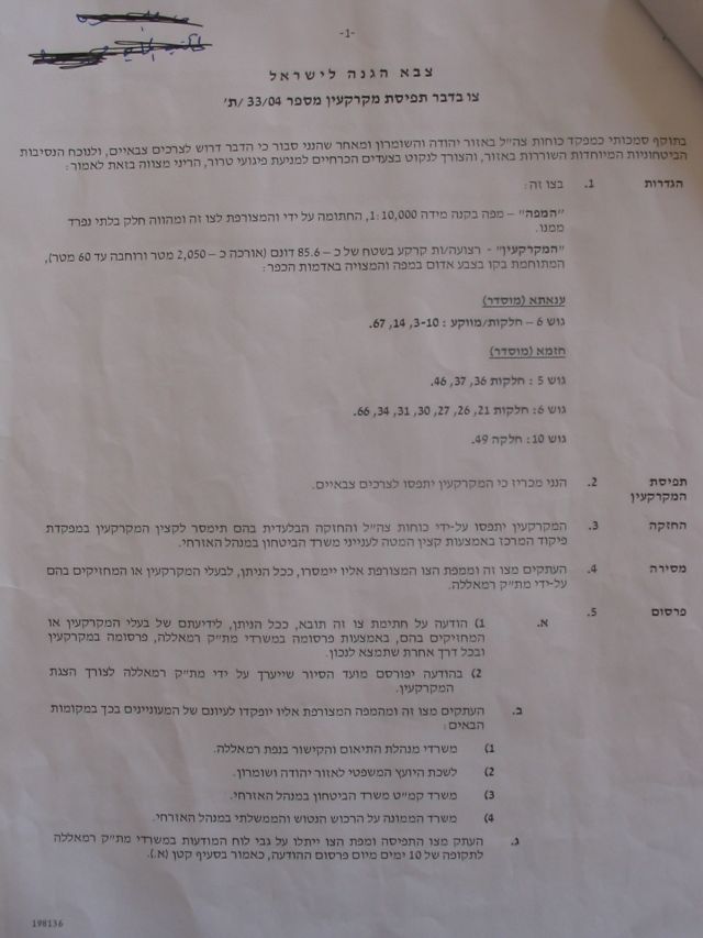
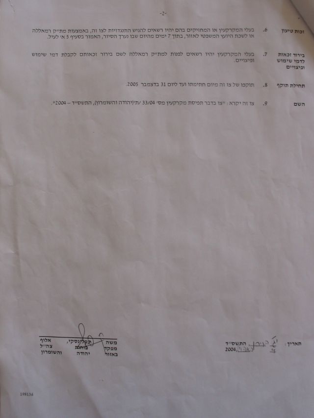
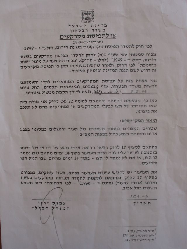
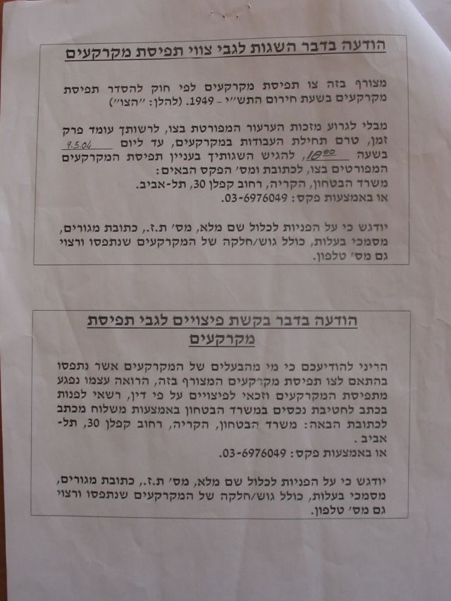
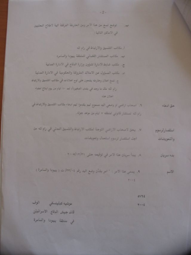
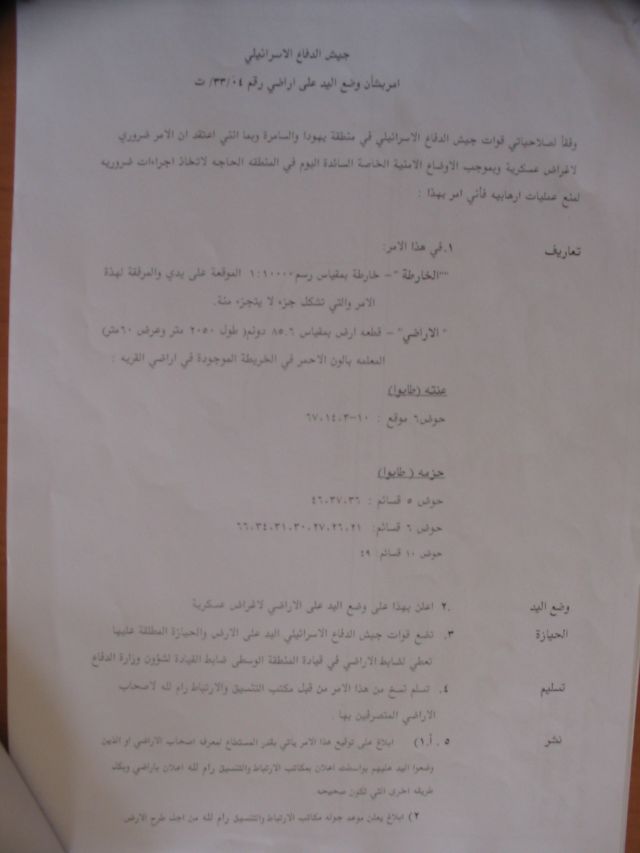
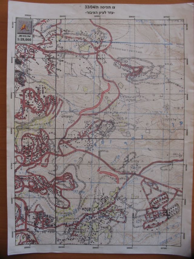
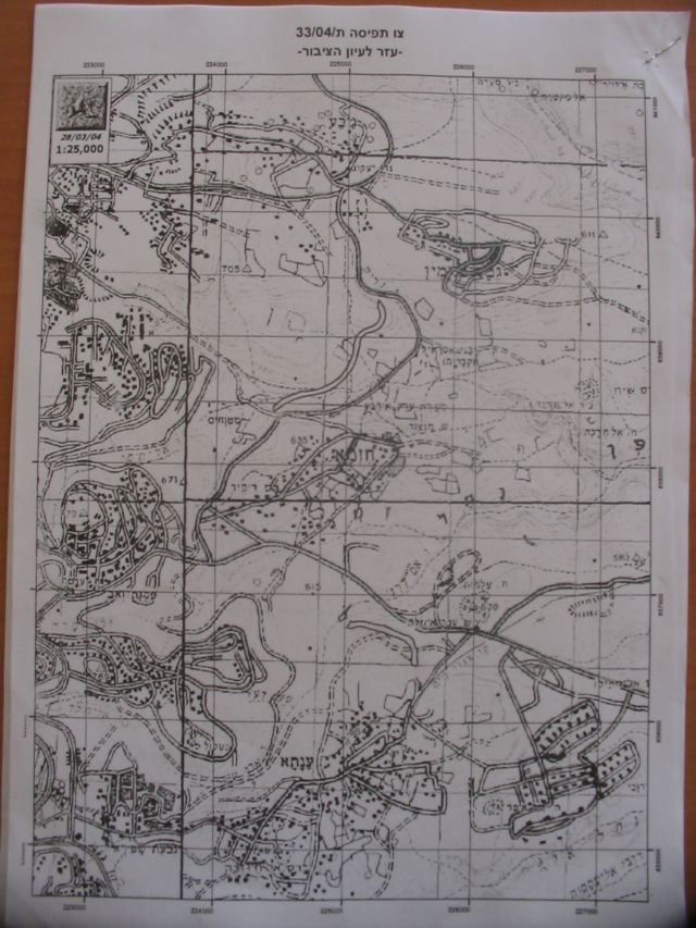


Appendix: Military Orders for the Segregation Wall in Hizma
[1] ARIJ Geographical Information Systems (GIS) Database, 2005.
[2] Hizma Village Council, February 2005.
[3] ARIJ GIS Database, 2005.
[4] ibid.
[5] Hizma Village Council, February 2005.
[6] ibid.
[7] ARIJ GIS Database, 2005. (population= 61317 )
[8] ibid.
[9] ibid.
[10] Hizma Village Council, February 2005.
[11] ARIJ GIS Database, 2005.
[12] Gush Shalom (http://www.gush-shalom.org/), 2005.), 2005.
[13] ibid.
[14] ARIJ GIS Database, 2005 and 39;Statistical yearbook of Jerusalem 2002/2003.39; Jerusalem institute for Israel Studies. December 2003 (http://www.jiis.org.il). ).
[15] Israel ratified the Convention in 1979.
[16] The International Convention on the Suppression and Punishment of the Crime of Apartheid (1973), Article II, Sections (c) and (d). See also the Convention on the Elimination of Racial Discrimination, Articles 2, 3 and 5.
[17] Ibid (Article 1).
[18] ARIJ GIS Database, 2005.
[19] ibid.
[20] ibid.
[21] Hizma Village Council, February 2005.
j1]Include a copy of the two military orders mentioned in this Paraghraph.]
Prepared by:
The Applied Research Institute – Jerusalem