In a surprising statement from Israeli official sources regarding the undergoing Segregation Wall built in occupied West Bank, a new route plan for the Segregation Wall have been put foreword by the Israeli security assemblage, which compliments according to the Israeli ''Security & Peace Council'' the Israeli supreme court ruling of June 30, 2004. The Israeli sources claim that the new route of the Segregation Wall will snatch only 400,000 Dunums (400 Km2) (7% of the area of the West Bank (5661 Km2)) of Palestinian lands in comparison to the original route which intended to cut off 900,000 Dunums (900 Km2) (16% of the area of the West Bank (5661 Km2)). The new plan has received preliminary approval from Israel's Prime Minister Ariel Sharon and Minister of Defense Mofaz but still require a government vote to pass.
According to the new route plan, the Segregation Wall will no longer include depth walls. In addition some parts of the main wall as the section which extends from the Palestinian Betunia town south of Ramallah District to the Israeli Beit Horon settlement on road 443 that links between Jerusalem and Makabiem settlement inside the green line will no longer be realized. Further alignment of the Segregation Wall will take place at the southern sector of the West Bank south of Hebron District were the route of the Wall will no longer be set to include few Israeli settlements such as: Susya, Zohar, Shima and Ofni'el.
It is just another Israeli Bluff
That what it really is; plain and simple, as the facts show that the route of the Segregation Wall published in the ''Seam Zone webpage'' on June 30, 2004; a website; administered by the Israeli Ministry of Defense; is eating away 18% (1024 Km2 _ 1024000 Dunums) of the West Bank's total area of 5661 Km2 along the western border and not 900 Km2 as Israel proclaims. Upon the proclaimed modification to the route of the Segregation Wall, the area to be located between the latter and the green line (under Israeli control) will constitute 633 Km2 (11.7% of the West Bank total area).
However, following the ICJ (International Court of Justice) historic ruling condemning the erection of the Segregation Wall, Israel have taken preventive measures not to provoke a world wide denunciation by resurging minor parts of the route of the Wall somewhat closer to the green line (the armistice lines of 1949) where only 19% (130 Km2) of the Israeli 690Km2 Segregation Wall (according to Israeli Map published in the Seam Zone webpage) are line-up with the green line. The Segregation Wall will enclose 101 Israeli settlement accommodating 370,000 Israeli settlers including settlers and settlements of occupied East Jerusalem.
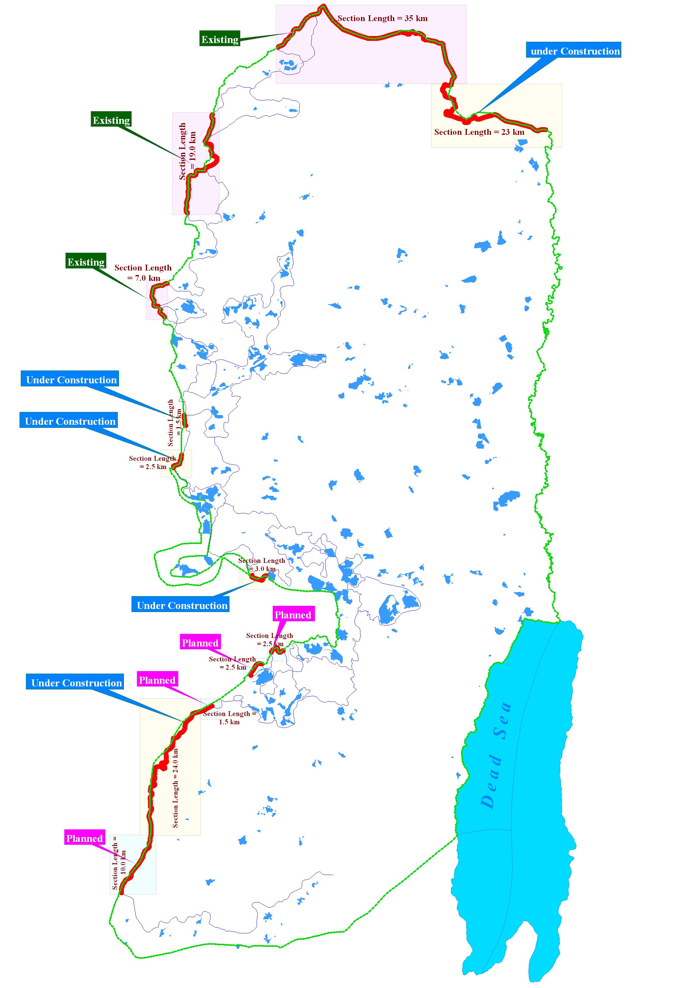
In August 2004, the Israeli Army issued new military orders to continue with the Segregation Wall at the southern parts of occupied West Bank on lands of six Palestinian villages (Beit Awa, Dier Samet, Beit Ula, Kharas, Beit Nuba and Surif) which are consistent with the route of the Segregation Wall as published in the seam zone webpage on June 30, 2004.
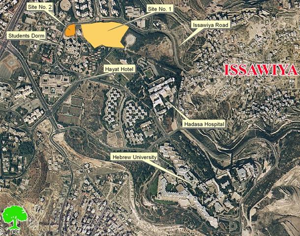
Also, the Israeli Supreme Court of Justice issued in November 2004 a verdict in favor of petitioners from six Palestinian villages located northwest of Jerusalem (Beit Surik, Qattanah, Beit Ijza, Beit 'Anan and Qubeibeh) to reroute the Segregation Wall set to penetrate their agricultural lands (the Betunia-Beit Horon section). The work at that section of the Segregation Wall was at halt prior to the verdict. The court verdict has caused minor shifting to the route of the Segregation Wall; few hundred meters west; and closer to the green line; where the Palestinian villages will again have access to 15000 Dunums of lands confiscated for the Segregation Wall in there area.

Is There Really a New Plan
Doubtful and most certainly not and all what Israel is trying to pull is just to mislead and misinform the world and play with numbers. Even though it is unlikely that the Israeli government will approve the new plan, Israel will still have cut off 11.7% (633Km2 – 633,000 Dunums) of the West Bank's area and entrapped it between the Segregation Wall and the Green Line. The Segregation Wall will still enclose on 90 Israeli settlement accommodating 330,000 Israeli settlers including settlers and settlements of occupied East Jerusalem.
These are the Facts
Even if Israel went on with its so-called new plan; and that is a long shot; this will not connote Israel's intentions to give-up the West Bank settlements that consume 3% of the West Bank or the 2% bypass roads nor it means that Israel gave up its plan to control the eastern border of the West Bank with a similar Wall which is anticipated to capture 22% of occupied West Bank. Furthermore, Israel would want to maintain control of the following Israeli settlement blocs: Ariel block, Maale Adumim block, Gush Etzion block, Qiryat Arba block, Giva't Ze'ev block, Moda'ien block especially as Israel's Prime Minister Ariel Sharon was able to cause a shift within the US foreign policy regarding the legal status of these settlements as President Bush stated in the letters of commitment to Sharon: ''In light of new realities on the ground, including already existing major Israeli populations centers, it is unrealistic to expect that the outcome of final status negotiations will be a full and complete return to the armistice lines of 1949, and all previous efforts to negotiate a two-state solution have reached the same conclusion. It is realistic to expect that any final status agreement will only be achieved on the basis of mutually agreed changes that reflect these realities.'' US President Bush's letter to Israel Prime Minister; April 14, 2004.
Prepared by:
The Applied Research Institute – Jerusalem