Beit Sahour (The Shepherd's Field)
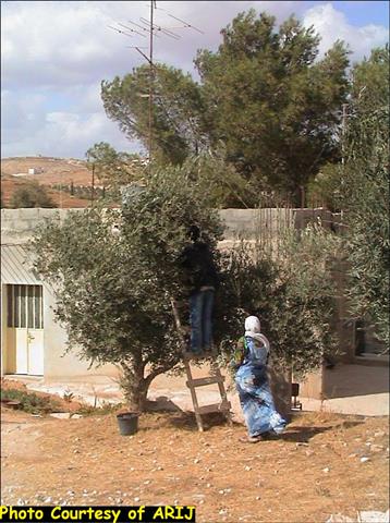
Beit Sahour is a Palestinian town located 1 km east of Bethlehem and is the biblical location of the Shepherd's Field. The town, which was once a major center for olive wood handcrafts, today suffers in a condition of nearly complete economic breakdown due to the continuous state of occupation and economic strangulation imposed by the Israeli occupying forces. Beit Sahour, like other Palestinian cities of the West Bank, has been subjected to massive human rights violations by the Israeli occupying forces.
Beit Sahour has been the recipient of massive Israeli shelling during the past four years of the second Intifada. The shelling damaged the houses of approximately 300 families; 27 of which saw their homes completely destroyed. The targeted families were relocated to rental housing and hotels by the Palestinian Authority. Social and psychological problems have also been an issue among children and families in Beit Sahour, and continue to effect the social fabric of the town.
Tourism, which is the lifeblood of the Bethlehem Triangle (including the towns of Bethlehem, Beit Sahour and Beit Jala) has been almost completely obliterated by the Israeli military's violent repression of the Palestinian Intifada. As a result, the unemployment rate among Palestinians exceeds 50% in the Bethlehem Governorate in addition to eliminating the population's main sources of income locally (tourism and agriculture), Israel has denied Palestinians access to employment in Israel. The bleak economic situation has forced many local residents to leave their homes and seek job opportunities elsewhere.
The Israeli Settlement plans-
Israeli colonization in the Bethlehem Governorate commenced in the late 1960s after Israel occupied the West Bank in 1967. Since that time, consecutive Israeli governments have built and expanded numerous Israeli settlements in the area. Today, there are 21 Israeli settlements in Bethlehem governorate and occupy a total area of 15112 dunums land. Table 1 below details the Israeli settlements in Bethlehem Governorate
Table 1: the Israeli settlements in Bethlehem Governorate
|
Name of the Settlement |
Date of Establishment |
No. of Settlers 2000 |
Area (Dunums)* |
|
Kfar Etzion |
1967 |
450 | 600 |
|
Rosh Zurdim |
1969 |
260 | 620 |
|
Alon Shavut |
1971 |
1600 | 610 |
|
Gilo |
1971 |
30200 | 3290 |
|
Ali 'Azar |
1975 |
450 | 420 |
|
Har Gilo |
1976 |
350 | 351 |
|
Mizpe Shalem |
1977 |
208 | 307 |
|
Tequ' |
1977 |
1000 | 955 |
|
Hadar Betar |
1978 |
NA | 50 |
|
Efrat |
1979 |
5930 | 1700 |
|
Ma'ale 'Amous |
1981 |
400 | 374 |
|
Ali David |
1982 |
NA | 51 |
|
Nave Daniyyal |
1982 |
649 | 460 |
|
Nikodumim |
1982 |
350 | 269 |
|
Giva'ot |
1984 |
NA | 90 |
|
Betar Illit |
1989 |
9760 | 3200 |
|
Giv'at Hamatous |
1991 |
NA | 262 |
|
Mshuli Darakout |
1991 |
201 | 51 |
|
Har Homa |
1997 |
NA | 1037 |
|
Beit Ban (Tsuref) |
1989 |
500 | 390 |
|
Afenat |
NA |
NA | 26 |
|
Total |
— |
52308 | 15112 |
Israeli authorities have used the settlements to unilaterally and illegally create facts on the ground' that contribute to Israeli territorial control. Since 1967, the confiscation of Palestinian land, the uprooting of olive trees and other agricultural produce, the demolition of houses, and other human rights violations have proceeded virtually without interruption.
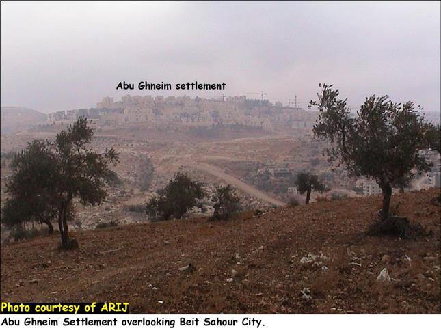
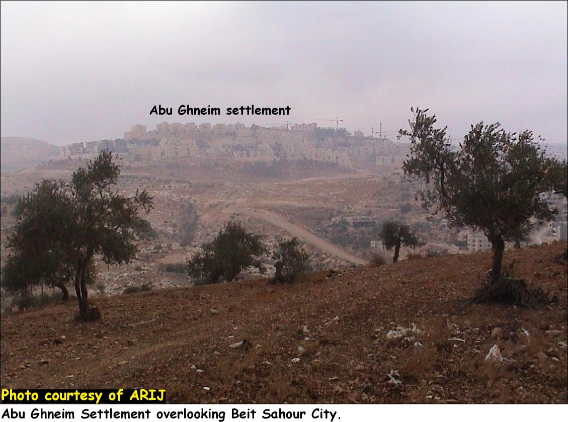
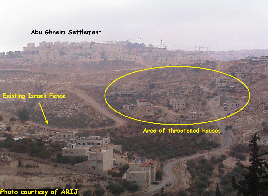
In 1997, the Israeli Government announced the establishment of Abu Ghneim 'Har Homa' settlement on Abu Ghneim mountain across from Bethlehem and Beit Sahour Jabal Abu Ghneim, formally a forest of non-native pine trees, was cleared and Israeli authorities began to construct the illegal settlement of Abu Ghneim 'Har Homa' on the site. The settlement is set on an area of approximately 2 km.2 and houses a population of more than 1,000 Jewish Israeli settlers. See Photo 1
Furthermore, construction of the Segregation Wall has resulted in the Israeli appropriation of significant portions of Palestinian land in the area and Israeli imposed security and buffer zones close to Abu Ghneim 'Har Homa' settlement are currently opening more territory for future settlement expansions.
The Targeted Localities: The Orthodox Housing Project
In 1995, the Patriarch of the Beit Sahour Greek Orthodox Church leased a plot of land near Jabal Abu Ghneim in order to establish a Housing Project for low income families. The purchase was also intended to prevent any Israeli plans to confiscate the land from the city of Beit Sahour following a declaration by Israeli Minister of Finance, Isaac Moda'ee, in 1991 that the area to be expropriated by Israeli occupation authorities. The land was leased for 99 years and construction began on the Orthodox Housing Project in 1995. See Photo 2
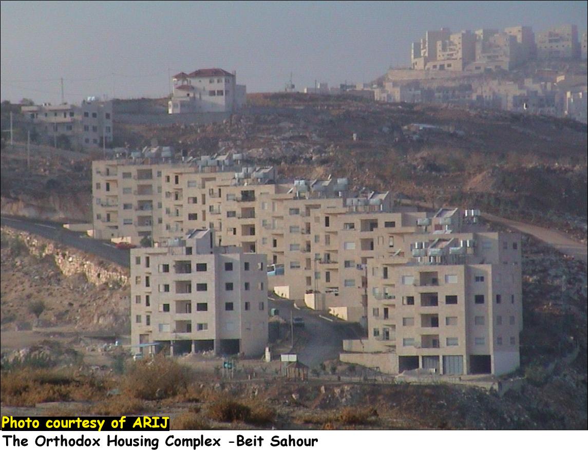
There are plans for 15 buildings containing 120 housing units. To date, nine buildings have been completed, housing more than 20 Palestinian families.
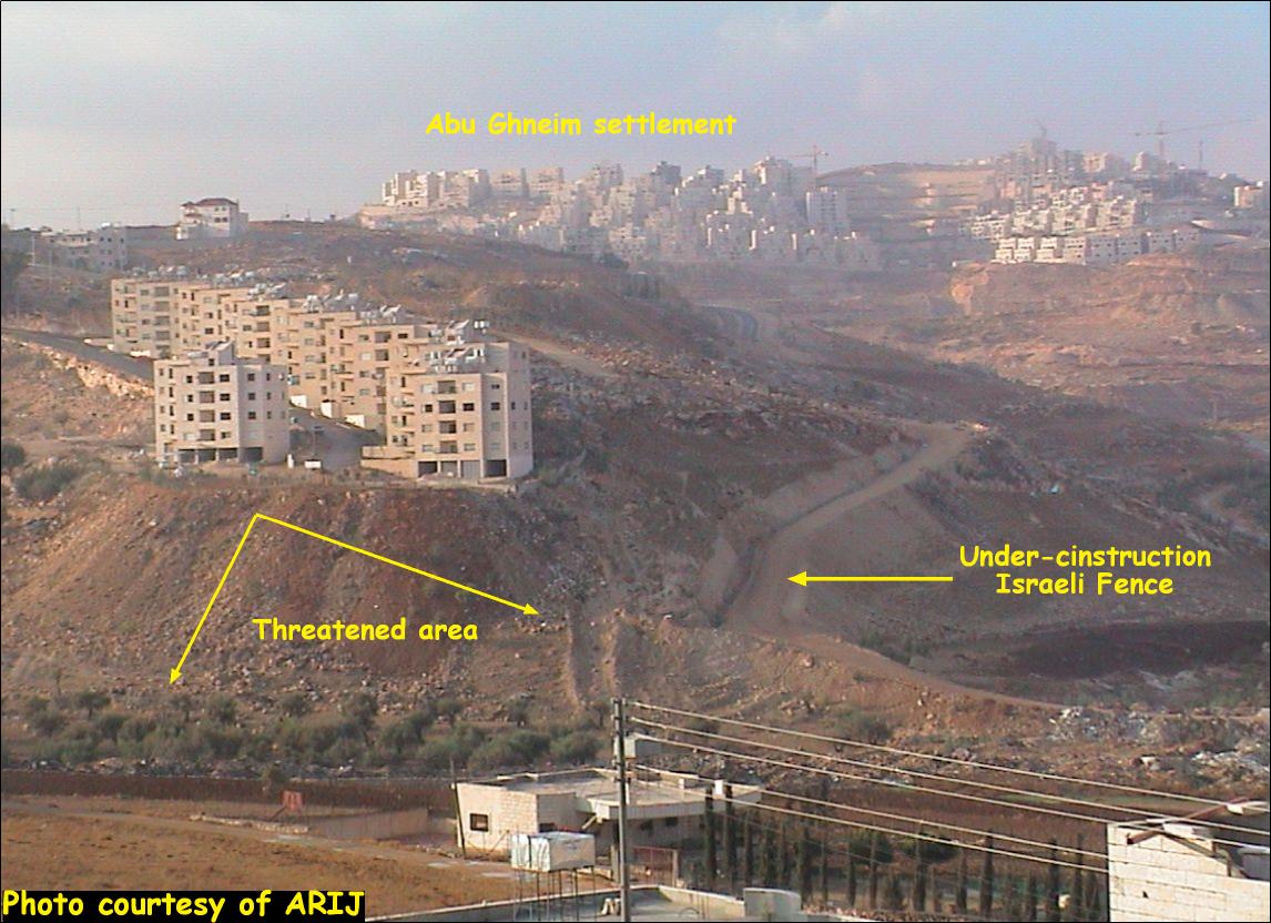
Jabal Al Deik
The neighborhood of Jabal Al Deik is northwest of Beit Sahour on a hill adjacent to the Abu Ghneim 'Har Homa' settlement. The neighborhood has been severely affected by the Segregation Wall which cuts very close to houses in the area. At least 80 Palestinian families live in Jabal Al Deik, of which 25 are threatened with the loss of their home by Israeli occupying forces. See Photo 3
The Israeli military orders in Beit Sahour City-
- In May 2002, Palestinian residents living in the Orthodox Housing Project and the Jabal Al Deik area received military orders to immediately end construction on the buildings. The Israeli occupation authorities submitted the orders under the pretext that the buildings did not have permits from the Israeli Civil Administration who restrict permits in Area C (Palestinian territory under Israeli control). The orders were submitted during the same period that planning for the Segregation Wall in the Bethlehem District was under way. Israeli plans call for the Wall to be built around the area occupied by the Orthodox Housing Project. There are also additional plans to construct a new military road to connect Abu Ghneim 'Har Homa' settlement with By-Pass Road #60 to the west. According to the plans, the road will cut below the housing project, severing it from the rest of Beit Sahour.
- In September 2002, Israeli occupying forces issued military orders to demolish 8 buildings in the Orthodox Housing Project and some houses in Jabal Al Deik under the pretext that the buildings were too close to the Segregation Wall. This order was challenged by lawyers for the Beit Sahour municipality and is currently frozen in Israeli courts.
- In May 2003, Israeli occupying forces returned to the area and left new military orders tacked olive trees near the Orthodox ousing Project. These orders declared that 300 dunums (3,000 m.2) of land close to the housing project would be confiscated in order to create a military zone in the area. Around 30 dunums of these lands are located in area ''A' and fall under full Palestinian control according to the Oslo II Agreement signed in 1995 by Palestinian and Israeli negotiators.
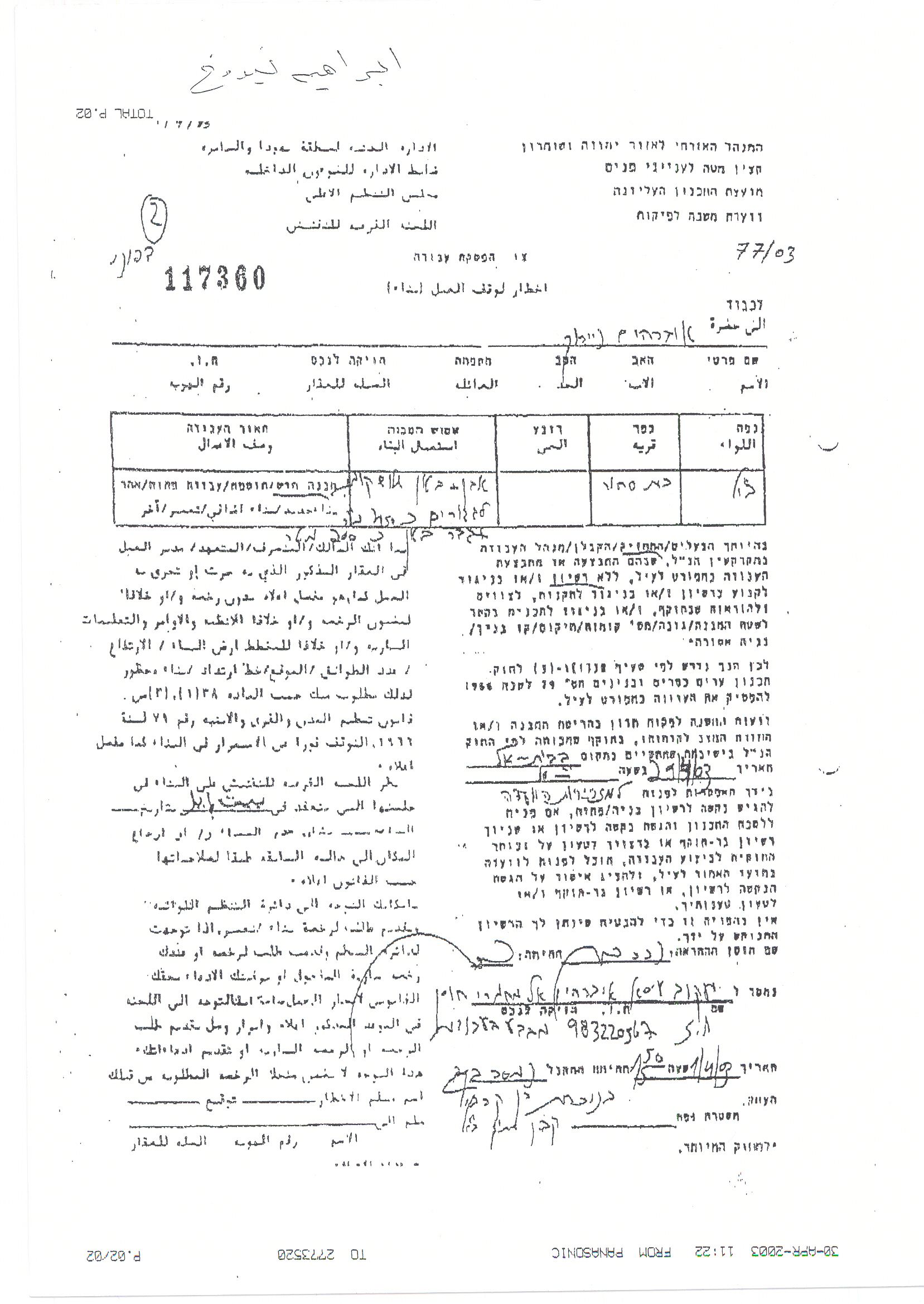
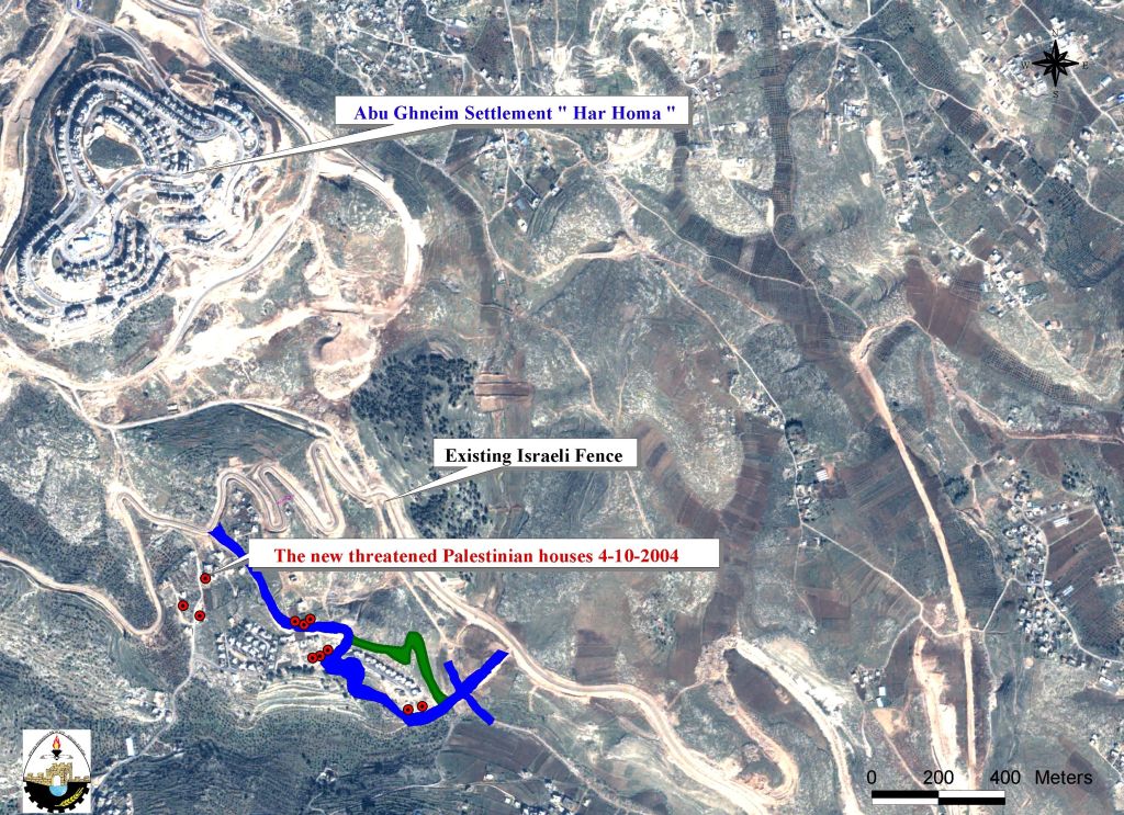
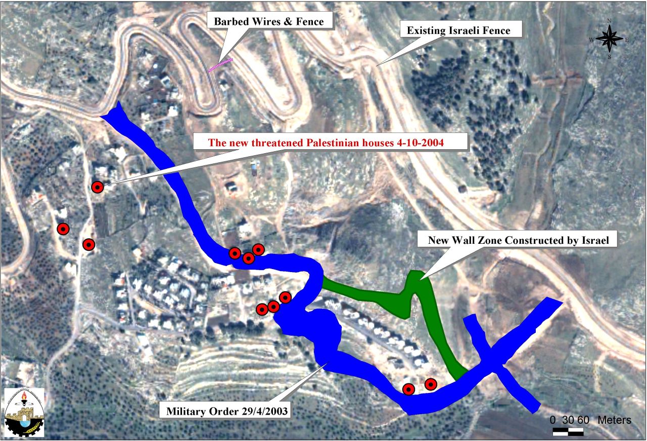
- On October 4, 2004 the Israeli occupation forces served demolition warnings to 16 Palestinian families living in Jabal Al Deik near the Segregation Wall and Abu Ghneim 'Har Homa' settlement and Palestinian families living in Building #9 of the Greek Orthodox Housing Project. See Photo 4
The property owners were ordered to immediately halt any construction projects and demolish the buildings within seven days from the date the military orders were issued. Israeli authorities claim that the houses are located in Area C (under Israeli control) and are being constructed without building licenses. The table below shows the list of owners and the date the military orders were issued.
Table 2: List of owners with the date the military orders.
|
No |
Owner |
# of Military order |
Date of Military order |
License # |
Date of license |
|
1. |
Iyad El Hilow |
11617 |
23_Dec_2003 |
7_Sep_2002 |
|
|
2. |
Naser Nayroukh |
117359 |
1_Apr_03 |
14_Aug_1999 / 8_Oct_2002 |
|
|
3. |
Ibrahim Nayroukh |
117360 |
1_Apr_2003 |
8_Oct_2002 / 9_May_1998 |
|
|
4. |
Rasim 'Ibayat |
117400 |
10_Jun_2003 |
27_Jun_2000 |
|
|
5. |
Thaljiya Daoud Jad Allah Hana |
118781 |
10_Jun_2003 |
31_Oct_2002 |
|
|
6. |
Hafiz Elias Qasis |
118783 |
10_Jun_2003 |
9_Mar_1999 / 27_Nov_1996 |
|
|
7. |
Nihad Yousef Najim |
118784 |
10_Jun_2003 |
9_Dec_1999 |
|
|
8. |
Emil Tawfiq Odeh |
12368 |
10_Jun_2003 |
5_Aug_1998 |
|
|
9. |
Jeris Hana Qumsiya |
119479 |
25_Sep_2003 |
31_Jan_1997 |
|
|
10. |
Jad'oun Khalil 'Ibayat |
120169 |
|
|
|
|
11. |
Jad'oun Khalil 'Ibayat |
120168 |
|
|
|
|
12. |
Jad'oun Khalil 'Ibayat |
13029 |
|
|
|
|
13. |
Jad'oun Khalil 'Ibayat |
121393 |
|
|
|
|
14. |
Jad'oun Khalil 'Ibayat |
13028 |
|
|
|
|
15. |
Orthodox Housing Project (Building No. 9) |
121394 |
18_Oct_2004 |
26_Nov_1997 |
|
|
16. |
Orthodox Housing Project Park |
121395 |
18_Oct_2004 |
26_Nov_1997 |

See Map of military order
Conclusion
The Israeli occupation authorities have exploited any means at their disposal to re-enforce Israeli control over the Occupied Palestinian Territories while creating facts on the ground to obstruct the creation of an independent Palestinian state. The Segregation Wall is one of the clearest examples of these Israeli policies. Israeli occupying forces have paired the Wall in Beit Sahour with a home demolition policy aimed primarily at the Orthodox Housing Project and Palestinian in Jabal Al Deik. As a result, more Palestinian families may lose their homes and be forced to move into the already crowded Palestinian cities. This alarming situation is already leading directly to unsustainable levels of population densities in the fixed Palestinian urban areas. By making living conditions within the Palestinian areas completely unacceptable and unsustainable, Israel's implementation of the Segregation Wall in the Bethlehem Governorate, as elsewhere, amounts to an indirect form of forced ethnic cleansing.
References:-
-
[1] Jabal Abu Ghneim is located less than two kilometers north of the city of Bethlehem overlooking Beit Sahour.
-
[2] Source: The Municipality of Beit Sahour, 2004.
-
[g1]Building licenses+ military orders 2004
Prepared by:
The Applied Research Institute – Jerusalem