Following the 1967 war, Israel initiated its settlement program in the occupied Palestinian territories in spite of the fact that such program constituted a major violation to the international law, the UN Security Council Resolutions and the Fourth Geneva Convention of 1949. The consecutive Israeli governments sponsored the Israeli settlements, which later on became epidemic and major obstacles to achieve real peace as they emphasized the Israeli occupation in the occupied Palestinian territories.
One of the earliest established Israeli settlements in the occupied West Bank territory was Kfar Etzion (1967) which is located some 20 kilometers from Jerusalem and 10 kilometers southwest of Bethlehem district. The settlement became the center of of Israeli settlements known today as the Etzion Bloc''. This bloc consists of 12 settlements built on confiscated Palestinian lands and spreads nearly over the entire western rural area of Bethlehem district.
Settlers of those settlement communities along with the Israeli Army denied Palestinian residents and owners of the land the right to expand or utilize these land. Furthermore, the Israeli settlements encircle the tri-city area (Bethlehem, Beit Jala & Beit Sahour), restrict its expansion, and cut it off from the surrounding rural Palestinian communities. Moreover, the Israeli built bypass roads in the area contributed in reshaping the topography of Bethlehem western rural area to befit the Israeli land grab in order to control the lands and define its new boundaries, and thus create facts on the ground, which may very much alter the outcome of any possible future peace negotiation.
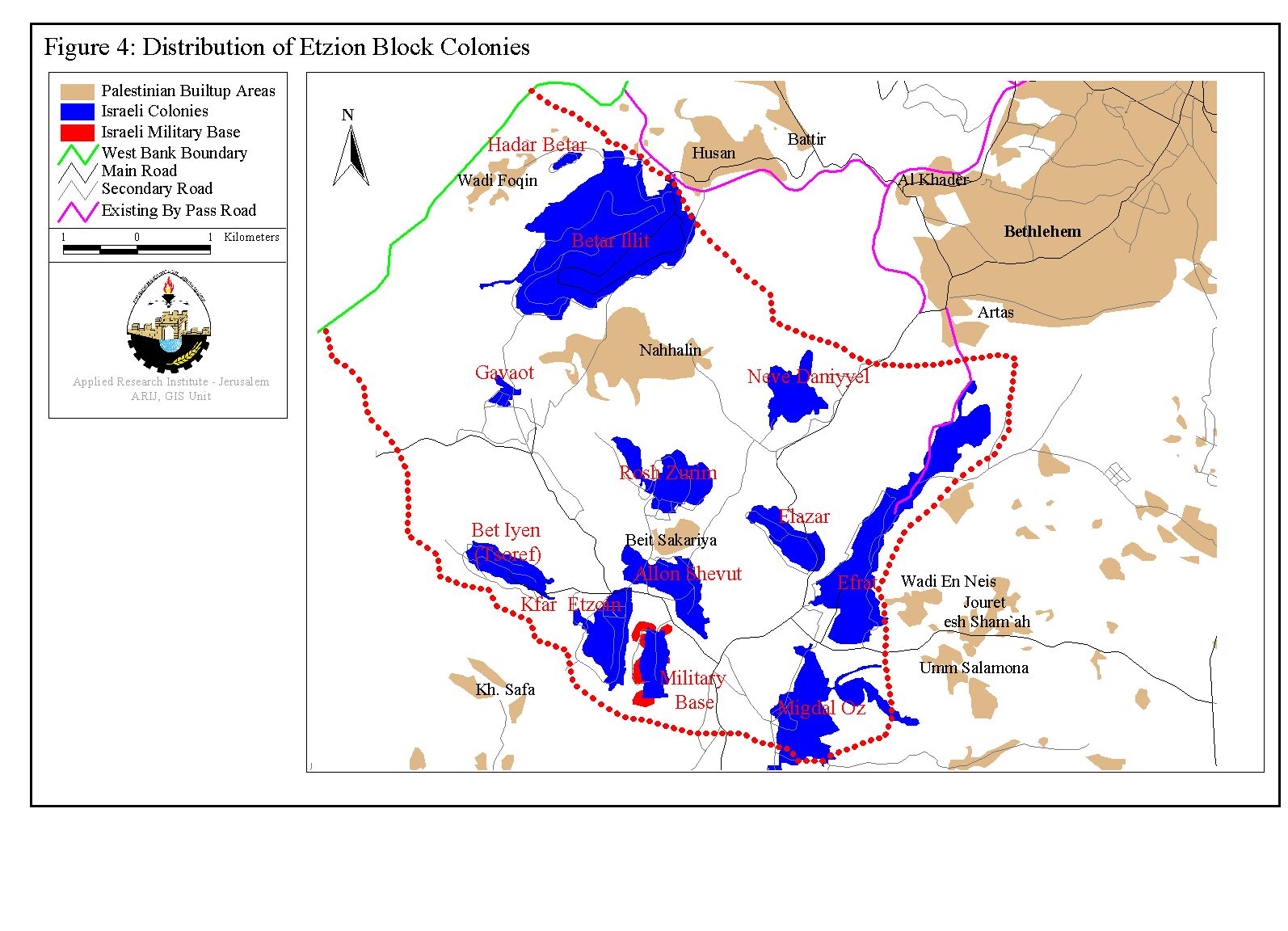
Table 1: Israeli settlements included within the Gush Etzion Bloc.
|
Name |
Population |
Date Founded |
Type |
|
Alon Shevut |
3,100 |
1970 |
Religious village |
|
Bat Ayin |
685 |
1989 |
Religious |
|
Betar Illit |
25000 |
1990 |
Haredi-Urban |
|
Efrat |
7,000 |
1980 |
Religious-Urban |
|
Elazar |
1518 |
1975 |
Religious |
|
Gev'ot |
75 |
1984 |
Urban + Nahal (Military Base) |
|
Hadar Betar |
110 |
1978 |
Religious Kibbutz |
|
Kfar Etzion |
463 |
1967 |
Religious Kibbutz |
|
Migdal Oz |
280 |
1977 |
Religious Kibbutz |
|
Neve Daniel |
1122 |
1982 |
Religious |
|
Rosh Tzurim |
321 |
1969 |
Religious Kibbutz |
|
Kfar Etzion- Nahal |
100 |
1967 |
Military Base |
|
|
|||
|
TOTAL |
39,774 |
|
|
Gush Etzion Bloc & the Segregation Wall
The fact that the Israeli (under construction) Segregation Wall acts as a climax achievement of the elongated Israeli settlement activities in the occupied West Bank; as it wrap-up 37 years of Israeli illegal activities within it; to be annexed to Israel.
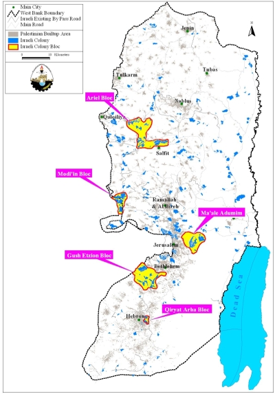
The Gush Etzion Bloc is one of five Israeli settlement Blocs (Qiryat Arba, Gush Etzion, Ma'ale Adumim, Modi'in & Ariel) located in the occupied West Bank that the Israeli government declared its decision to maintain them under its jurisdiction. This Israeli insistence will constitute a dilemma to the fulfillment of any foreseen Peace process between the Palestinians & the Israelis; particularly as the existence of these settlement blocs was endorsed on several occasions (although not officially) by the United States government (Bush Administration; 2000-2004).
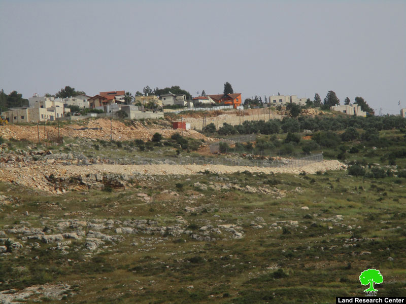
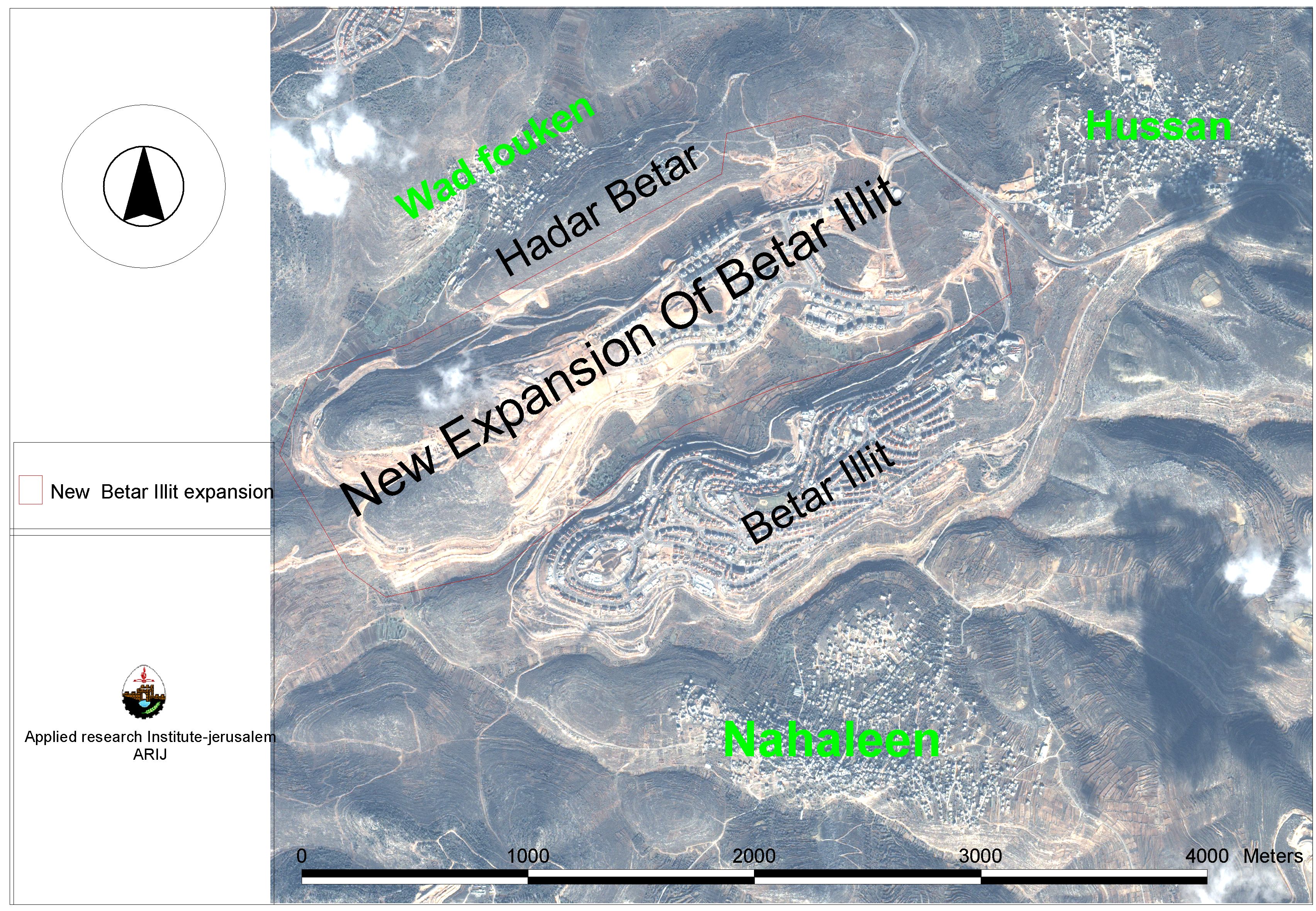
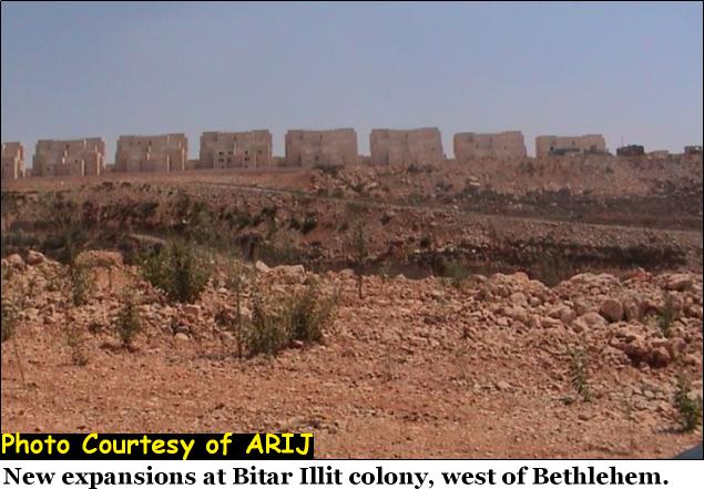
The 12 Israeli settlement communities located within the Gush Etzion settlements bloc are growing towards each other by expanding their built-up area and constructing a network of bypass roads among these 12 settlement communities. Expansions in some of the Israeli settlements in Gush Etzion bloc were more explicit than other settlements; See photo 1
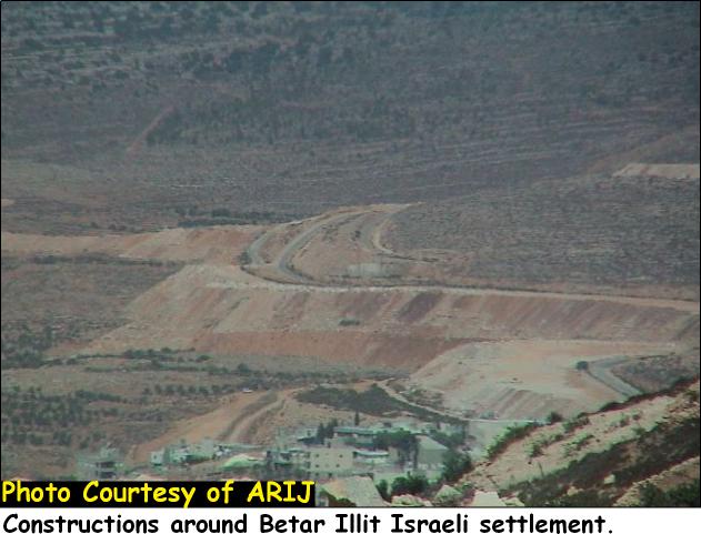
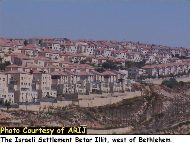
Betar Illit and Efrat settlements are those settlements in the Etzion Bloc among which carry out constant expansion to their built-up area. The correlation of the Gush Etzion settlements will cut off the five Palestinian rural communities in that area (Battier, Husan, Nahhalin, Wad Fukin & Al-Jab'a) from each other and from the main centers of Bethlehem district. See photos of expansion
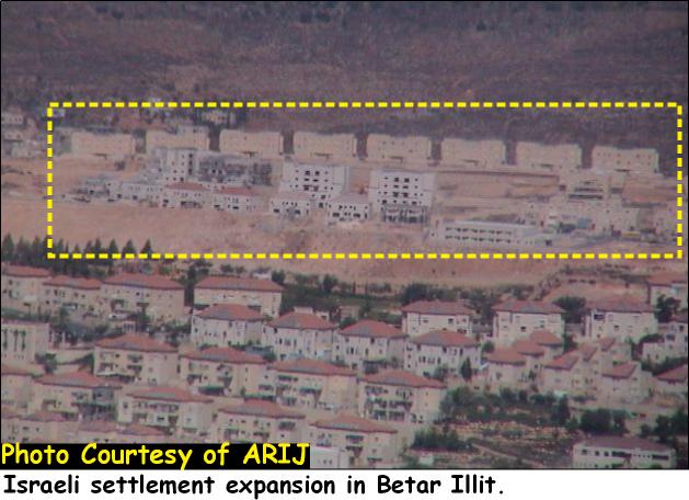

Photo 2 & Photo 3: Expansion at Betar Illit settlement
Table 2: the expansion rate of Israeli settlements in the Etzion Bloc (All of religious type) between 1996 & 2003.
|
NAME |
DATE |
DIST. |
AREA |
AREA |
Area 2003 |
Expansion |
% |
|
Gavaot |
1984 |
Beit lehem |
59 |
90 |
90 |
31 |
53% |
|
Hadar Betar |
1978 |
Beit lehem |
36 |
73 |
73 |
37 |
103% |
|
Elazar |
1975 |
Beit lehem
|
271 |
343 |
420 |
149 |
55% |
|
Allon Shevut |
1971 |
Beit lehem
|
570 |
719 |
1500 |
930 |
163% |
|
Neve Daniyyel |
1982 |
Beit lehem |
157 |
549 |
549 |
392 |
250% |
|
Rosh Zurim |
1969 |
Beit lehem
|
399 |
930 |
930 |
531 |
133% |
|
Efrat |
1979 |
Beit lehem
|
832 |
942 |
2133 |
1301 |
156% |
|
Kfar Etzion |
1967 |
Hebron |
629 |
902 |
902 |
273 |
43% |
|
Betar Illit |
1989 |
Beit lehem |
1389 |
3201 |
4188 |
2799 |
202% |
|
Migdal Oz |
1977 |
Hebron |
461 |
948 |
948 |
487 |
106% |
|
Bet Ain (Tsoref) |
1989 |
Hebron |
337 |
723 |
723 |
386 |
115% |
|
TOTAL |
|
5140 |
9420 |
12456 |
7316 |
142% |
|
Betar Illit Expansion
Palestinian Communities Trapped Within the Segregation Wall & the Gush Etzion Bloc
The five Palestinian villages that constitute the southwestern rural community of Bethlehem district are Battier, Nahhalin, Husan, Wad-Fukin and Jab'a. These Palestinian villages are facing a double jeopardy because of the Israeli Segregation Wall that will cut these villages off from the main urban center of the district and thus lose all access to public services. Likewise, these five communities are dependent on each other for a network of services that will no longer be feasible, as the Segregation Wall will isolate these villages from each other like scattered islands encircled by fences and cement blocks. The Segregation Wall will also cut these communities off from their natural resources; natural springs, irrigation wells, cultivated lands, area of territorial expansion, etc.
The following table shows the targeted western rural villages of Bethlehem district and area confiscated over years of Israeli occupation.
|
Village |
Total Village Area |
Israeli Bypass Roads1 |
Israeli Settlement2 |
Area isolated by the Segregation Wall3 |
%1+2+3 of total village area |
|
Battir |
7165 |
150 |
0 |
1470 |
23 |
|
Husan |
7295 |
600 |
3500 |
560 |
64 |
|
Nahhalin |
17250 |
975 |
3000 |
10025 |
81 |
|
Jab'a |
7120 |
600 |
700 |
5820 |
98 |
|
Wadi Fukin |
4347 |
0 |
800 |
2400 |
74 |
|
Total |
43176 |
2425 |
8000 |
20275 |
71 |
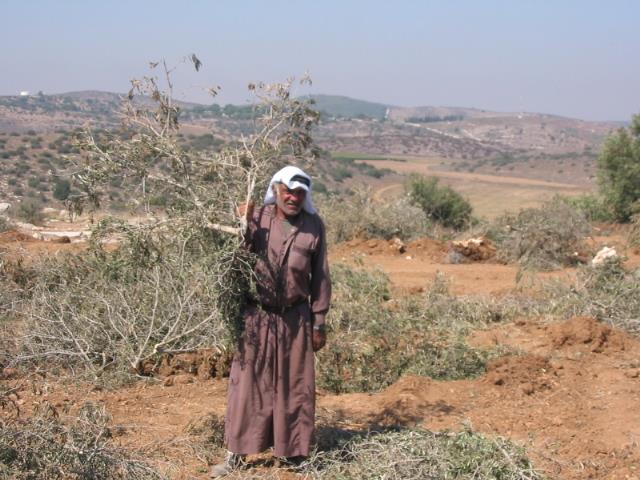
The Israeli practices have dramatically affected the agricultural sector, which represents the backbone of the Palestinian economy. In the case of Bethlehem, the western rural villages used to represent the district's food-basket until the Israeli Army coarsely confiscated considerable parts of these villages; allegedly for ''Military Use''.
Furthermore, the Israeli Segregation Wall along with the Israeli illegal measures, over 37 years of occupation signify an Israeli persistence to disparage the international law and the United Nations Security Council resolutions that recognize Israel as an occupying power in the Palestinian territories (captured after the 1967 war). The Israeli settlements, bypass roads, houses demolition, collective punishment are merely examples of Israeli violations over 37 years of occupation which call for a firm stand by the international community to put and end to the Israeli practices in the occupied Palestinian territories.
Prepared by:
The Applied Research Institute – Jerusalem