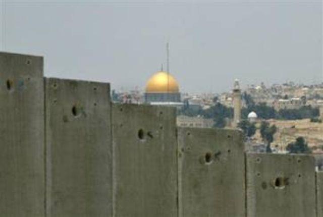
The dome of the rock in the old city of Jerusalem appears behind the Wall in Abu Dis- Photo courtesy of Reuters
Introduction
Despite all international positions, last of which was the International Court of Justice's decision declaring the Israeli Wall as an illegal entity that must be removed and financial compensation must be paid to affected Palestinians, Israel is still pressing on the construction of the Wall. Regardless of the description Israel is trying to pin on the Wall (such as the Security Barrier, Terror-Prevention Wall, the New Temporary Border), the fact remains that it is a racist wall which caused, and will continue to cause, humanitarian, social, economic, environmental and political problems.
Background:-
The total area of Historic Palestine is 27,000 km2. The West Bank and Gaza Strip only represent about 22% of the the aforementioned area (specifically 6,000 km2). The total area of the West Bank is 5,635 km2 while the area of the Gaza Strip is 365 km2. Hebron governorate is the largest governorate in both the West Bank and the Gaza Strip as its area is estimated to be 1,065 km2, added to that the Palestine's share of the Dead Sea, estimated to be 200 kilometers.
According to the Oslo agreements in 1993, the West Bank area was divided into three zones: A, B and C. Zones A and B were handed back to the Palestinian National Authority representing 42% of the total area of the West Bank and Gaza Strip. These two zones include all the Palestinian built up areas which became under the Palestinian civil and security administration.
Zone C, which represents the remaining parts of the West Bank and Gaza Strip remained under the full Israeli control as it contained all the Israeli settlements and military camps, as well as lands targeted for future Israeli expansions.
The Green Line represents the separation line between the Palestinian lands occupied in 1967 and Palestinian lands occupied in 1948 (what is now termed as 'the State of Israel'). The section of the Green Line in the west separating the West Bank and Israel is the longest as its length exceeds 312 kilometers. Additional borders include the Jordan River, whose length is 120 kilometers, in addition to Palestine's share of the Dead Sea which is about 200 kilometers. Add to these borders, the Gaza Strip separating border and Israel which is estimated to be 60 kilometeres. As such, the prospected Palestinian state would consist of two separate parts (the West Bank and Gaza Strip) with a narrow passage connecting those two parts.
Putting Palestinian desires aside, Israel is working on isolating, as much as possible, the different parts of the West Bank through dividing the lands by by-pass roads used primarily by Israeli settlers living in more than 250 settlements which occupy a little more than 2% of the total area of the West Bank and the Gaza Strip. Moreover, plans exist for future expansions which would use about 4% of land occupied in 1967.
As for the by-pass roads, they are about 100 and connect Israeli settlements in the West Bank and Gaza Strip together. The total by-pass roads occupy about 1% of the total area of the West Bank and Gaza Strip. Moreover, there are at least 600 road blocks, of which 140 are of permanent nature, all set up with the aim of cutting the geographical contiguity amongst Palestinian areas.
The Idea and Stages of the Segregation Wall
The latest attempt to abort Palestinian hopes is the construction of the Segregation Wall, which is rightfully termed 'The Crime of Our Time'. This Wall cuts deeply inside the West Bank as to ensure the annexation of the largest number of settlements into Israel. See Map 1
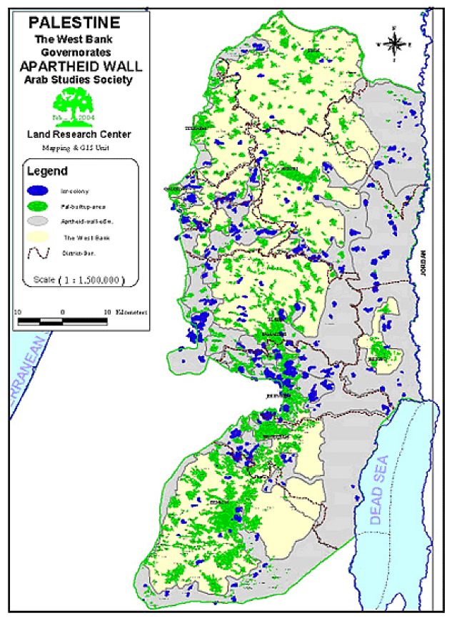
Map of the Apartheid Wall in the West Bank with many corridors going deep inside the West Bank proper
The idea of erecting the Wall was first publicly announced in April 2001 by the head of the Labor government, Ehud Barak. Such an idea matched the ideology of the current premier, Ariel Sharon, who strongly opposes the idea of Israeli withdrawal to pre-June 5th, 1967 borders. Sharon has put this ideology in practice 30 years ago in his Seven Stars Plan which called for an Israeli control over the western and eastern hills of the West Bank while connecting them via the establishment of a series of settlements. The main goal of this plan was to protect Israeli proper as well as to prevent the establishment of a Palestinian state in any shape or form.
The design of the current Segregation Wall aims at establishing three cantons according to the following scheme:
-
The first canton (area = 1930 km2) is designed to be established in the north of the West Bank. It includes the Governorates of Jenin, Tubas, Nablus, Tulkarem and Qalqilyia. This canton is to be connected to Ramallah via Za'atara crossing.
-
The second canton (area = 710 km2) is set to include the Governorates of Bethlehem and Hebron.
-
The third canton (area = 60 km2) is set to isolate the Governorate of Jericho from its surroundings.
The following are the different stages of the Wall:
The first stage:
It extends from Zabouba crossing in the northwest of Jenin city to the village of Habala in southern Qalqiliya. This stage is completed. During this stage, a number of villages were completely segregated behind the wall or separated from their lands. Thousands of fruitful trees of different types were uprooted and dozens of wells and cisterns were seized.
The Second Stage:
The Israeli government is currently working feverishly on executing the second phase of the Segregation Wall in the villages and towns of Al Az Zawiya, Masah, Iskaka and Deir Balout in the Governorates of Qalqilia and Salfeet. In addition, the Israeli government is working in villages of Budrus, Rantees, Na'aleen and Al Midya, located northwest of Ramallah governorate. Nowadays, Israel is erecting the Wall around Jerusalem starting from the town of Rafat, going through Al Ram and Qalandiya to reach the current borders of Jerusalem (identified following the 1967 borders). A large part of the Wall was completed in the areas of Abu Dis, As-Sawahra Ash Sharqiya, Beit Jala and Beit Sahour. In terms of Hebron governorate, the second stage is going through its initial steps as buffer zones has been established around the settlements of Kharsina and Kiryat Arba.
This stage is considered to be much more damaging than the first one as the Wall is expected to go 10-25 kilometers deep into Palestinian lands forming fingers like corridors, especially in Ramallah and Salfit Governorates, as to assure the annexation of the largest number of Israeli settlements, especially those located in Ariel, Latron, Jerusalem and Gush Etzion. Ironically, the length of the Green Line separating the West Bank and Israel is 312 kilometers; with the implementation of the Wall pan, the length of the Line would reach up to 442 kilometers!
The Third Stage:
This stage will encircle the West Bank from the east. It will start from the village of Bardala in the northeastern corner of the West Bank and reaches the town of As Samou' in southern Hebron. The largest possible number of settlements located in the Jordan Valley, the eastern hills and great parts of the heights in the West Bank will be annexed into Israel. The western wing (created by the first and second stages) and the eastern wing (created by the third stage) will be connected by a number of finger-like corridors as to ensure the annexation of most of the Israeli settlements located in the West Bank. These corridors ( fingers) include the following:
-
A northern corridor seizing the settlements of Elon Moreh located to the north of Nablus.
-
A second northern corridor annexing the settlement of Itmar, also in Nablus.
-
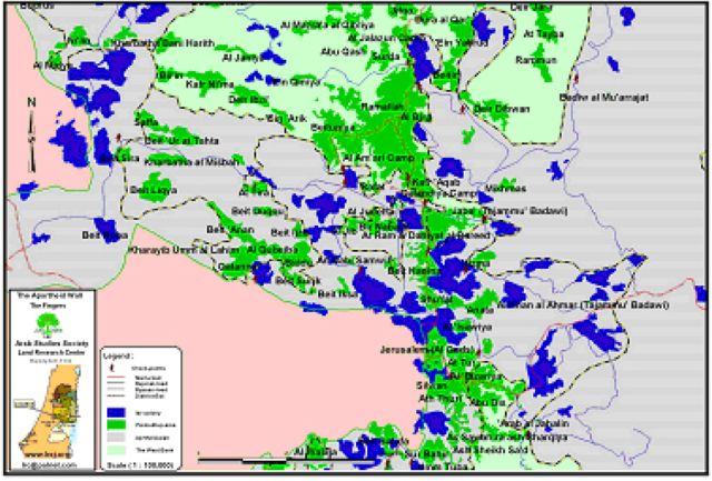
A third corridor located on the border between the governorates of Nablus and Ramallah. Its width will be the largest as it aims to annex the settlements of Shilo, Eli, Ma'ale Levona, and Rahaleem. See Map 2

The three eastern fingers in the north of the West Bank annexing a number of settlements
-
A fourth corridor extending from the settlement of Beit El. Settlements annexed into this corridor include Pesagot, Kokhav Ya'avov, Ma'ale Mikhmas and Ofra, all in Jerusalem. See map 3
The fourth corridor annexing a number of Settlements in the middle of the West Bank
-
A fifth corridor located in the Governorate of Bethlehem. It is planned to include the Settlements of Tekoa, Nokdim, Asfar ( Metzad Shmu'on) ), in addition to Ma'ale Amos. See Map 4
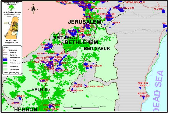
The fifth corridor in Bethlehem district
-
A sixth corridor is expected to be erected as to reach the limits of the city of Hebron. It will annex Settlements of Kiryat Arba, Kharsina as well as the Settlements of the Old City, in addition to the Settlements of Ma'on, Karmel, Pene Hever ( Ma'ale Hever). See Map 5
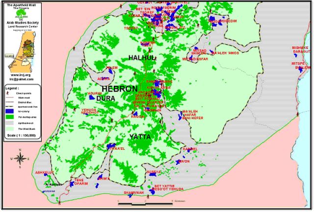
The sixth corridor in Hebron district
According to these six corridors, most of the 35 Israeli Settlements (better known as the Allon Settlements), in addition to the previously mentioned 20 Settlements would be annexed into Israel.
Erection of the Wall: What Does it Mean in Terms of the Palestinian Statehood?
The Wall, in its three stages, will transform the West Bank into three, unconnected cantons with an area that does not surpass 2700 km2. Such an area constitutes about 10% of Historic Palestine area and is about 50% of the area of the West Bank. The length of the Wall will reach to 1,000 kilometers as the length of its eastern wing is expected to reach 300 kilometers while the length of its western and northern wings is expected to reach 700 kilometers.
The percentages of the annexed lands in the governorates of the West Bank vary according to the number of Settlements in it. As such, the governorates located at the heart of the West Bank stand to lose most of their lands, especially Jerusalem which will lose more than 90% of its lands. Jericho and Bethlehem governorates will lose the same percentage as Jerusalem while Hebron, Tubas and Ramallah governorates stand to lose a bit more than 50% of their lands for the benefit of the Wall. The rest of the Palestinian Governorates will lose a lesser percentage of their lands.
Taking the above-mentioned facts into consideration, one can only conclude that creating a viable Palestinian state that has geographical and population contiguity is virtually impossible with the existence of the Israeli Racist Segregation Wall.
The Effects of the Wall on Agriculture, Environment and Population:
The erection of the Wall has led to the uprooting of thousands of fruitful trees and the isolation of thousands of fertile dunums behind the Wall, especially those filled with olive trees and located in the northwest of the West Bank. Other types of uprooted trees include citrus trees and grapevines.
Moreover, the erection of the Wall has led to the confiscation, the isolation and pollution of water sources in the affected areas. More than 50 cesspits were isolated and polluted in the northwestern region of the Wall.
On the social level, the Wall separated families from each other as more than 4,000 families are prevented currently from visiting each other due to the Wall blocks installed in those areas which caused psychological, social as well as economical problems.
As for the newly established by-pass: there are more than 100 such roads occupying about 1% of the total area of the West Bank. These roads has led to great environmental damage in terms of destroying the natural look of the lands they go through, uprooting trees, plowing of lands as well as causing direct damage to the biodiversity of the targeted regions. Add to this, the destruction of Green Areas, forests and grazing lands which led to bird and animal migration.
In short, the erection of the Israeli Segregation Wall constitutes a third Nakba (disaster) for the Palestinians. The Wall separates people and rips families apart. It, also, devours Palestinian lands, natural resources as well as private and public properties.
The Wall and the International Court of Justice (ICJ)-Hague:
Despite of all Israeli efforts to change the name of the Wall, the fact remains that it is a Segregation Wall built on stolen Palestinian lands under the pretext of security. This Wall is considered illegal in the eyes of the whole world.
Despite attempts taken by Israel to undermine the legitimacy of the ICJ as an international legal establishment which has the right to intervene in this matter, and the repeated Israeli attempts to affect the outcome of the court as well as the usage of a multitude of deception and ploys by the Israeli High Court (in terms of issuing a temporary halt of wall constructions), the ICJ has issued its firm decision declaring that this Wall is illegal, must be demolished, and stressing that affected Palestinians must be compensated for the loss of their lands and properties.
The UN General Assembly endorsed the ruling by majority of votes. Now that UN General assembly accepted such ruling, Israel is obliged to abide to international laws related to this issue. Moreover, all national and international human rights organizations must pressurize on Israel to stop its violations and occupation of the Palestinian lands. A special responsibility is placed upon the shoulders of the UN as it is considered to be the International knight safeguarding human covenants and human rights to live free and independent.
Prepared by
The Land Research Center
LRC