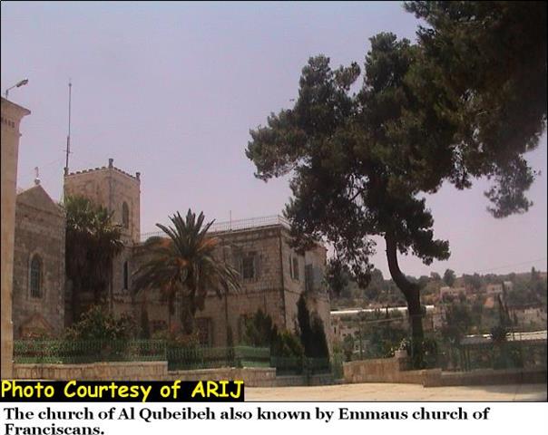
Al Qubeibeh, a Palestinian village located 11 kilometers to the northwest of Jerusalem city. It is situated on 235 dunums of land and houses a population of 2500 inhabitant. Across the last hundred years and today, the village carried a stream of social and cultural traditions. It has several archeological sites, among of which the remains are of a famous Crusaders church. See Photo 1

The village is also surrounded by a number of hamlets such as Kherbet Al Kaboosh, Kherbet Kharabtani, Kherbet Al Judeideh which contain ruins of walls, building structures, remain of an Olive oil press, and a tunnel which crosses a nearby valley (Al Dabbagh 1991).
Almost 50 families living in Al Qubeibeh village hold Jerusalem IDs. A total of 200 families are refugees who expelled by the Israeli occupation forces during the 1948 war, while the rest of villagers hold Palestinian ID cards. Seven clans compromising Al Qubeibeh total population. They are ( Zahran, Hamoda, Saeed, Samara, Omar, Om Ali and Wahdan).
A number of social infrastructure facilities exist in Al Qubeibeh village; Table 1 below summarizes these facilities:
Table 1: Facilities in Al Qubeibeh village
| Al Qubeibeh school (students300) | Schools | |
| Four kinder garden | 2-Kinder Garden | |
| B-Men's club | A-Women's club | 3- Sports Clubs |
| Salah Al Din Mosque | 4-Mosques | |
| Al Qubeibeh monastery | 5-Monastery | |
| Three | 6-Community charities | |
| One | 7-Highway street | |
| One | 8-Bus station | |
| Al Qubeibeh church (Emmuas Church) | 9-Church | |
| One | 10-Swimming Pool | |
| One | 11-Parks | |
| One | 12-Bankwes |
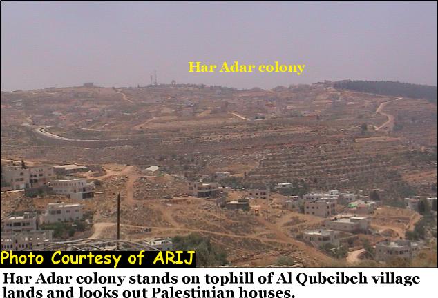
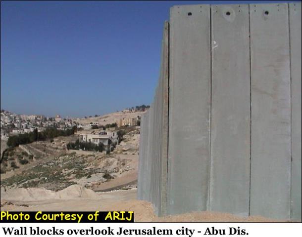
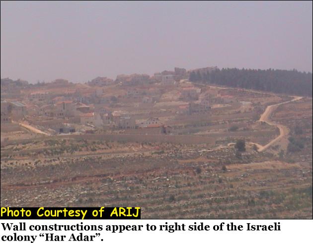
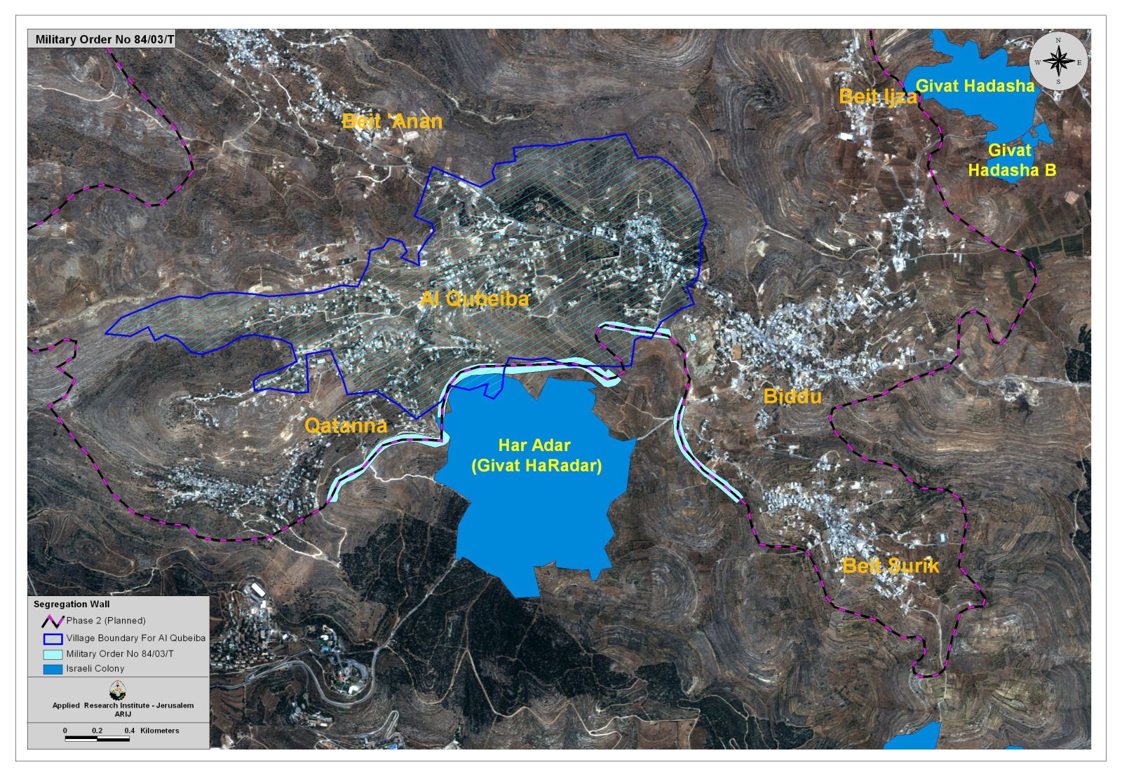
Following the 1967 war, the Israeli forces confiscated most of the Palestinian agricultural lands of Al Qubeibeh village for colonization purposes and hundreds of olives trees were uprooted that time. Nowadays, the village of Al Qubeibeh overlooks the illegal Israeli settlement of Har Adar, which is part of Givon settlement Bloc and is 80 meters away from the village. See Photo 2
Har Adar together with the settlements of Giv'at Ze' ev, new Giv'on form the Giv'on settlement Bloc which houses approximately 14,000 Israeli settlers. See table 2:-
Table 2: Settlement name, year of Establishment and location.
|
Settlement Name |
Year of Establishment |
Location |
|
Givat Zeev |
1977 |
Jerusalem |
|
Givon |
1978 |
Jerusalem |
|
Har Adar (Givat HaRadar) |
1985 |
Jerusalem |
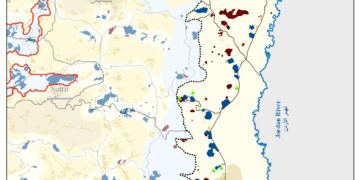
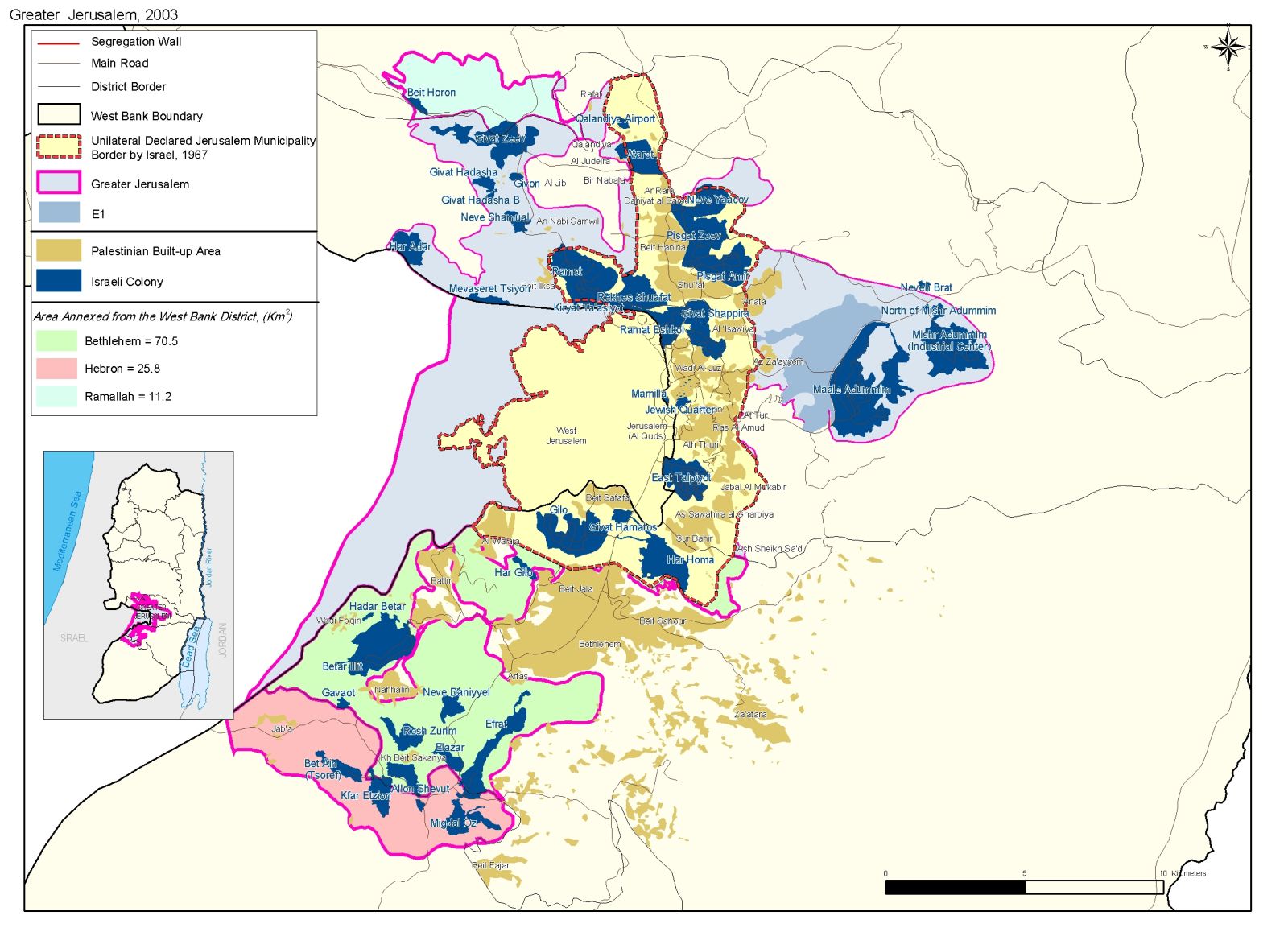
Givon bloc of settlements is part of the Greater Jerusalem (Jerusalem Envelope) scheme, an Israeli plan formally and publicly endorsed by the Israeli Knesset on 28 May 1997. It is a ring of Israeli settlements integrated into Jerusalem urban borders and include the following settlements: Har Adar, Giv'at Ze'ev, New Giv'on, Kiryat Sefer, Ma'ale Adumim, Efrat, Etzion Bloc and Betar Illit. See Map of Jerusalem Envelope. The settlements were all constructed on lands confiscated from Palestinians following the 1967 war. See Photo 3.. The settlements were all constructed on lands confiscated from Palestinians following the 1967 war. See
The Wall in Al Qubeibeh village:-
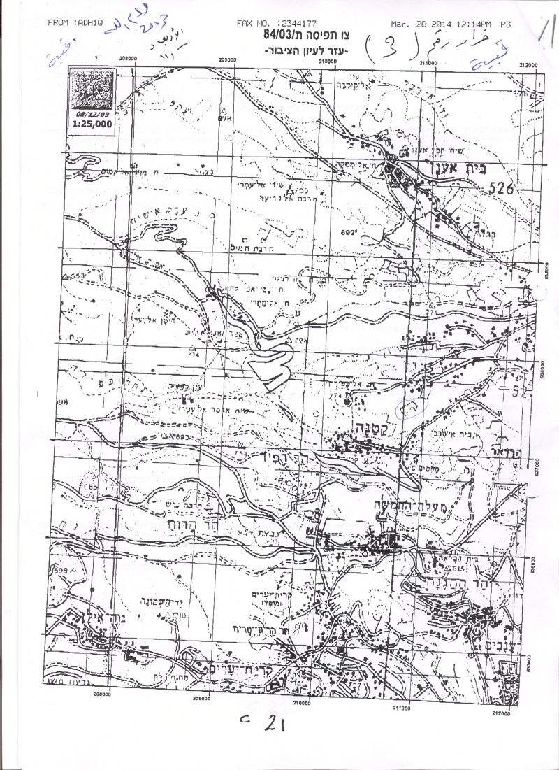
In December 2003, the Israeli occupation forces (IOF) handed Al Qubeibeh villagers military order number 03/84/T Judea & Samaria 2003) stating the confiscation of 25 dunums of agricultural land for the construction of the Segregation Wall. The purpose of seizure was to erect a Segregation wall on lands originally owned by Palestinians. The military order also included villagers of Qatanna (16 Km northwest of Jerusalem). Read translation of military order:
Israel Defense Forces
Order to Seize lands n0 03/84/T
According to my authorities as a Military Chief Commander in the Region of Judea and Samaria, and as I believe that it is imperative for military reasons due to the special security situation in the region, I order the following:
1. The ''Map'' signed in scale 1: 10000 and attached to the order is an essential part of this order. The ''Lands'' : An area of land which is 192.5 dunums (2439 meter long and 55-187 meters wide) marked in red in the map :
Al Qubeibeh
-
Block 10: In Beir Abo Tar.
Qatannah
· Block 3: Al Mekab area
· Sha'ab mansi area
· Kherbat Beit Shabab, Masmul area
· Baten Abu Lhye area
2. I announce by that the above mentioned lands are seized for military reasons
3. The IDF seize the lands and have an absolute control over it that is given to the officer of the central command officer of lands who is responsible in the ministry of defense.
4. These copies are to be given by the District Co-ordination Office ''The DCO'' of Ramallah to the owners of land.
5. Copies are found with maps for those who are interested in the following places:
· DCO of Ramallah.
· Offices of the Juridical advisor in the region
· The office of commander responsible in the ministry of defense in the civil administration.
· Office responsible of absentee and public lands in the civil administration.
6. The owners of land have the right to go to the DCO in Ramallah in order to get more information about their right of land use expenses and compensation.
7. The Validity of this order starts at the date signed till 31/12/2005 .
8. The name of this order is: ''Order to seize lands n0 03/84/T (Judea & Samaria) 2003.
Mosheh Kaplenski
Chief Commander of The Israel Defense Forces in Judea & Samaria
9/2/2003 -Signature
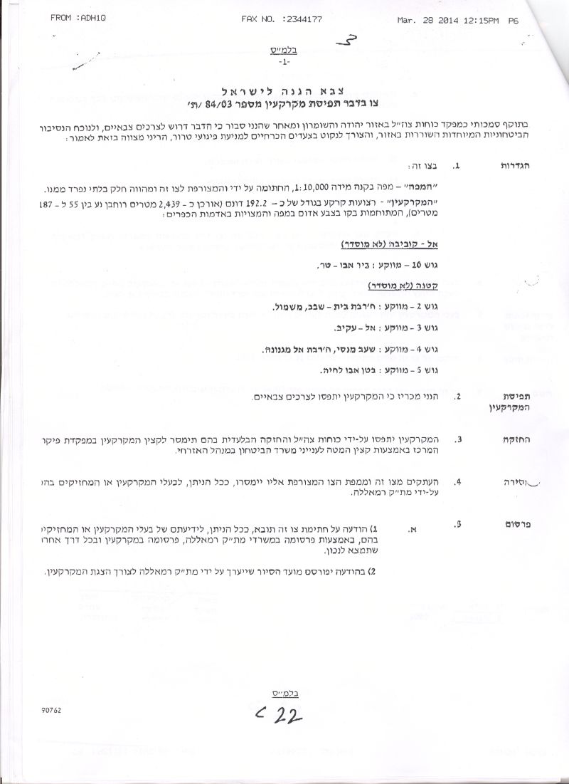
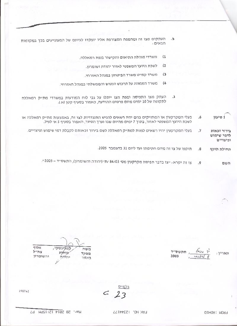
The Israeli military order as distributed by the Israeli occupation forces to villagers of Al Qubeibeh and Qatannah
The two hundred dunums designated for the construction of the Segregation Wall are owned by Palestinians families of Al Qubeibeh and Qatanna (Click here for related cases about Qattanah village, case 1 & case 2). A number of families living in Al Qubeibeh will loose their land according to the military order. The families are : Al Qawwas, Jawdat, Diab, Samara and Abdulah. In return to Al Qubeibeh village council leader, Mr. Sidqi Sa'ed, the planned route of the Wall is 30 meters far from a number of Palestinian houses situated atop of a mountain where the wall route is planned to be constructed, and is opposite in direction to the Village council building. See map of military order as provided by the IOF, and translation of map). A number of families living in Al Qubeibeh will loose their land according to the military order. The families are : Al Qawwas, Jawdat, Diab, Samara and Abdulah. In return to Al Qubeibeh village council leader, Mr. Sidqi Sa'ed, the planned route of the Wall is 30 meters far from a number of Palestinian houses situated atop of a mountain where the wall route is planned to be constructed, and is opposite in direction to the Village council building.
 s
s
The wall Route:-
The Segregation Wall, if completed, will run along the southern part of Al Qubeibeh village and to the north of the Israeli settlement of Har Adar. Residents of Al Qubeibeh village objected the construction of the Wall in their area soon after the military order was issued and appealed to the Israeli Supreme Court which later on March 2004 issued an order to halt the construction of the Wall in the village and the nearby Palestinian communities for one week.
The fate of Al Qubeibeh village after the Israeli Supreme court order:-
In June 29, 2004, the Israeli Supreme Court issued an order to reroute the wall path in nine Palestinian villages located to the northwest of Jerusalem City, among of which is Al Qubeibeh. The towns and villages affected by the wall constructions are: Beit Surik, Biddu, Qattana, Al Qubeibeh, Beit Anan, Beit Leqia, Beit Duqqu, Beit Ijza, Neve Samuel and Beit Iksa. The section of the wall that was planned in Al Qubeibeh village (northwest Jerusalem city) was set for reconsideration by the Israeli court due to the differences expressed by both Palestinian cities of Al Qubeibeh and the Israeli military commander Moshe Kaplenski. , Al Qubeibeh, , Beit Leqia, Beit Duqqu, Beit Ijza, Neve Samuel and Beit Iksa. The section of the wall that was planned in Al Qubeibeh village (northwest Jerusalem city) was set for reconsideration by the Israeli court due to the differences expressed by both Palestinian cities of Al Qubeibeh and the Israeli military commander Moshe Kaplenski.
Under the pretext of military reasons, Israel managed to seize about 200 dunums (192.5 dunums) of land mainly for constructing the Segregation Wall around the settlement of Har Adar and on the expense of Palestinian lands from Al Qubeibeh . The seized area severely affects the Palestinian Built-up area due to its location close to the planned wall route, at the same time distances from Har Adar settlement. If the Israeli intention is to build the Segregation Wall for security reasons, then it should be build on the borders recognized by the International community (June 1967 borders). On the ground, Israel is illegally confiscating Palestinian lands under security claims and causing a change of the 1967 borders and violates the United Nations resolutions 242 / 478 / 497, International Laws, the basis of Madrid conference for Peace and the Road Map designed by the Quartet.
Impacts of the Segregation Wall on the village of Al Qubeibeh:-
1- Social Impact:
The revealed military order of the Segregation Wall in Al Qubeibeh will have severe humanitarian and social impacts on villagers if the military order is applied in the area. Palestinians of Al Qubeibeh and the nearby affected villages are likely to be imprisoned in their lands and properties. The social relationships between the segregated areas will be severely disconnected as lands marked for seizure will disrupt their social activities. The Segregation Wall will affect the educational system in particular as many students head to nearby villages such as Qattanah and Beit 'Anan. Many students will be cut off from schools, universities and specialized medical care centers. Furthermore, the Wall hinders the natural territorial expansion of the village according to the village's master plan.
Economic impact:-
Unemployment rate reached to 80% as a result of the current political situation, where most of Palestinian workers lost their jobs inside Israel and turned to work in agriculture. The construction of the Segregation Wall will hinder families from earning their living as they're witnessing the loss of their lands for the Segregation Wall constructions. About 200 Olive trees are threatened to be uprooted for Wall constructions according to Al Qubeibeh village council leader, which in turn affects the economical sector.
The seizure of land is carried out for absolute military purposes according to the Israeli government, mainly for providing security. The order, if applied, is likely to involve seizure of more Palestinian lands and further violates all international laws and conventions: 'The Law of belligerent occupation recognizes the authority of a military commander to maintain security in the area and to protect the security of this country and heir citizens. However, it imposes conditions on the use of this authority. This authority must be properly balanced against the Right, needs, and interest of the local population.'
Prepared by:
The Applied Research Institute – Jerusalem