Beit Sira is a Palestinian village located 22 Km southwest of Ramallah district. Before the creation of the State of Israel in 1948, the village spread over 8000 Dunums of land, which belonged entirely to the village residents. From that time on, the village was subject to numerous forays of the State of Israel's colonization plans.
In 1948, the residents of Beit Sira fled from their village when news of massacres committed against the Palestinian population by the Israeli militias unfolded. The war at that time resulted in the depopulation and destruction of more than 400 Palestinian villages and Beit Sira miraculously escaped that faith. When the residents came back few weeks later, parts of their village were under the jurisdiction of what became the State of Israel. In the year 1949, the Armistice line was drawn along the West Bank borders. An area located northwest of Jerusalem where Beit Sira and other Palestinian villages are located became known as 'No Man's land'. Consequently, some 3200 Dunums (40% of the village area) of Beit Sira's agricultural lands became located within the 'No Man's land'.
The adversity of Beit Sira residents did not stop at that as it reoccurred in 1967 when Israel occupied the West Bank and Gaza and again coerced many Palestinian residents living in villages along the West Bank western borders to flee their villages. Albeit the fact that Beit Sira escaped total destruction, as was the faith of many villages, the Israelis demolished many houses in addition to grapping 1680 Dunums of land (35%) of the remaining area of the village. In due course, Israel designated 840 Dunums of the 35% seized land in 1967 for Makkabim settlement (established in 1982). At that time, Beit Sira suffered the loss of 61% (4880 Dunums) of its original area that existed before 1948.
Today, Beit Sira stands on 39% (3120 Dunums) of its original area with a population of 3000 (441 families) inhabiting 480 Dunums while the remaining area represents the village agricultural lands and its open spaces designated for future urban expansion.
Nevertheless, the residents of Beit Sira as many residents of other Palestinian towns & villages have always been worried about the never-ending Israeli colonization activities in the West Bank as news of further confiscation always reported in the Israeli media. For an example, in 1998 the Israeli government approved the construction of a commercial center at the Horon intersection south of Beit Sira village. The commercial center was to snatch 627 Dunums of Beit Sira's lands and the irony of subject was that the Palestinians; the true owners of the land were required to attain a special permit from the Israeli authority to enter the area where the commercial center was to be built. So far, the plan for the commercial center is on hold but the designated land for the Israeli project is off limit to Beit Sira's residents.
Beit Sira & the Israeli Segregation Wall
Just like many Palestinian towns and villages, Beit Sira had its share of the abhorrent Israeli Segregation Wall. In December 14, 2003, the Israeli Army issued a military order # 03/104/T to seize 149 Dunums of land in Beit Sira for erecting the segregation wall. The order was a segment of the segregation wall in that area which penetrates Beit Sira's lands. However, the order was yet to include a supplementary order to split the village literally into two parts. As the residents of Beit Sira elevated the level of protest against the Israeli segregation wall, the latter temporary stopped the 03/104/T seize order to re-evaluate the route of the segregation in the area.
In June 24, 2004, the Israeli Army issued a new military order # 03/105/T categorized as (Border Amendment) where a shift in the route of the segregation wall is apparent westward of Beit Sira built-up area in. The segregation wall new route sets along the marked-line of the 'No Man's land' area and the Horon (Latrun) road, which is also the proposed 'safe passage' route between the West Bank & Gaza. Furthermore, the new route of the segregation wall (# 03/105/T) will consume 222 Dunums of Beit Sira's agricultural lands in addition to the isolation of 1945 Dunums which includes the 627 Dunums designated for the commercial center. Click to see Map
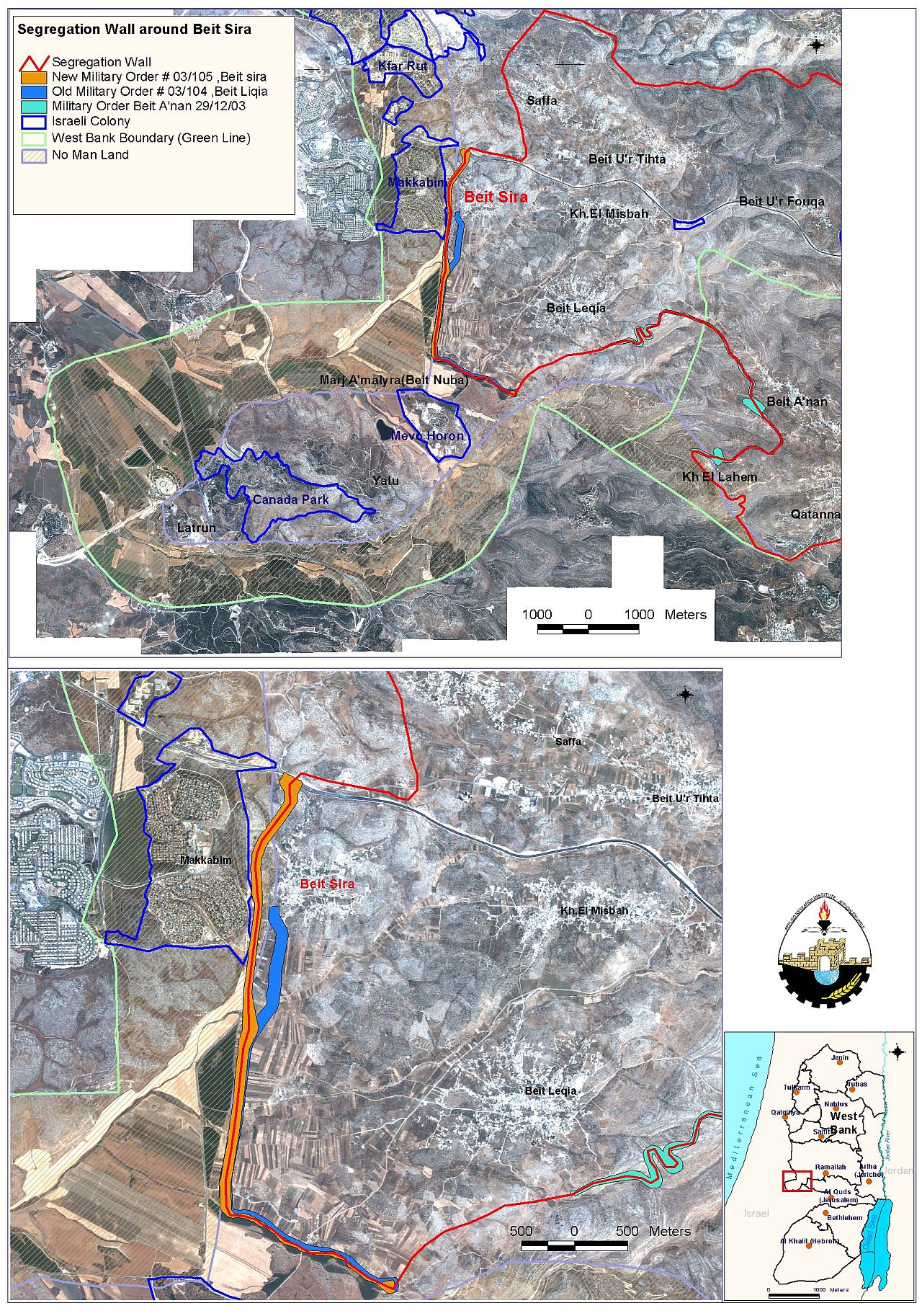
In view of that, the residents of Beit Sira village will only dominate 953 Dunums (11.9 %) of Beit Sira's original area (8000 Dunums) existed before 1948; including 480 Dunums that constitutes the village built up area.
The following table exhibits the diminishing of Beit Sira's area over different periods.
|
Year |
area Confiscated in Dunums |
Purpose |
|
1948 |
3200 |
Part of the land annexed to Israel and the other part included within the 'No Man's Land'. |
|
1967 |
1680 |
832 Dunums annexed to Israel and 840 Dunums designated for Makkabim settlement; established in 1982. |
|
2004 |
222 |
Designated for the route of the segregation wall |
|
2004 |
1945 |
Number of Dunums isolated behind the segregation wall toward Israel; including 627 Dunums for commercial center in Horon. |
|
Total 7047 |
||
|
Area remaining under the control of Beit Sira residents |
||
|
|
480 |
Built-up Area |
|
|
473 |
Agricultural land & open space |
|
Total 953 |
||
|
Grand Total |
8000 |
|
Prepared by:
The Applied Research Institute – Jerusalem