Location and Population:
The town of Kafr Thuluth is located 6 kilometers away from the Green Line. Its lands extend from the town of Azzoun in the north to reach the town of Sanniriya in the south, the Green Line in the west and the town of Deir Istia in the east. It is, also, located 12 kilometers southeast of Qalqiliya city. See Map of Location
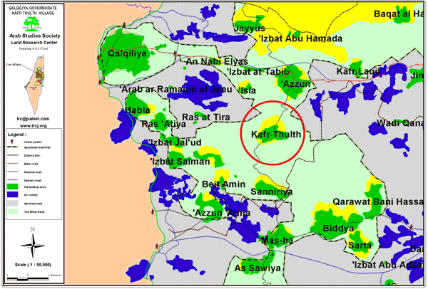
Kafr Thuluth ( in red circle) surrounded by the Wall
The pre-1967 population of the town reached to 1,200, a number which decreased to 820 after the 1967 War due to the transfer of Palestinians (forced mifration) to the nearby cities and towns. As for the latest population statistics (as late as 2002), it indicates that the current population of the village is about 5,000.
The town is considered the ''mother'' village of the sub-villages'': Izbat Salman, Izbat Jal'ud, Izbat Al Madwar, Ras at Tira, Ras Atiya, Al Daba' and Wadi ar Rasha. As such, the town of Kafr Thuluth and the surrounding sub-villages are considered as one unit in terms of population and agricultural lands.
Following the 1948 War, 20% of the towns' lands which amounts to about 4,000 dunums were occupied. Two Israeli settlements were established on those occupied lands; Kharsheem settlement which was built atop of the ruins of the Palestinian town of Khraish and the settlement of Niereed which was built in a location called Ahrash Al Zaqoor. The remaining 80% of lands were considered within the borders of the West Bank. There are four main families living in the town of Kafr Thuluth. They are:
-
The family of Shahawneh which includes the subfamilies of Hasan, Khateeb and Ghafra;
-
The family of Oudeh which includes the subfamilies of Khaled, Issa, Jaber and Arar;
-
The family of Gharrabah; and
-
The family of Maraba'ah
Added to that, a number of small refugee families which constitute about 5% of the total population.
It has been estimated that before the 1967 War about 85% of the town's population relied exclusively on agriculture and cattle raising while the remaining15% depended on governmental jobs as their main source of income. A major shift took place between the years 1967 and 2000 as more than 45% of the Palestinian farmers shifted to work as laborers inside Israel whereas the remaining 55% worked as employees, merchants and laborers inside the Palestinian Occupied Territories. Yet, after the eruption of the second Intifada in late September 2000, more than 60% of the workforce of the village became unemployed.
Area of the Town
The area of the town and the associated villages is 16,000 dunums classified according to the following distribution:
-
1,500 dunums reserved for residential builtup;
-
8,500 dunums filled with olive trees;
-
115 dunums built atop it plastic houses for the purpose of growing produce;
-
2,500 dunums of fertile soil (not yet used);
-
500 dunums in which vegetables are planted;
-
500 dunums of citrus trees;
-
1000 dunums used for sheep feed;
-
500 dunums located in valleys; and
-
500 dunum reserved for municipal and agricultural roads
It is worth mentioning here that an Israeli colonial campaign was conducted on lands of the town in 1976 when the Israeli authorities established the settlement of Oranit. Today, there are three settlements established on lands expropriated from this town: Oranit, Ma'ale Shomron and an extension of Alfei Menashe.
The Israeli Segregation Wall:
The construction of the Segregation Wall will lead to the confiscation of 7,285 dunums of Kafr Thuluth and the sub-villages associated. This figure constitutes 45% of the total area of the Kafr Thuluth. It will also lead to the total isolation of the sub-villages of Ras at Tira, Al Dab'a and Wadi ar Rasha as the Wall is encircling them from four different directions. Such a grip, transformed the residents of these villages from being farmers and/or workers inside Israel into jobless people. Furthermore, the erection of the Segregation Wall has deprived the residents of Kafr Thuluth from any prospect of future expansion to meet the demands of natural population growth.
The Effects of the Segregation Wall
1. Economic Effects:
-
The erection of the Wall has led to the expropriation of a vast dunums filled with olive and citrus trees. Specifically, the confiscation led to the impoundment of 3,000 dunums packed with olive trees, 40 plastic houses, 1,000 dunums of watered trees, 1,600 dunums of vegetables in addition to 800 dunums of bushes-filled lands. Moreover, Israeli bulldozers plowed about 873 dunums and uprooted 2,000 olive trees to make way for the erection of the Wall.
-
The complete destruction of the water network valued at hundreds of thousands of dollars. In addition to that, Israeli occupation forces destroyed a 300 mmeter3 water storage tank as well as 20 water tanks as to impede the ability of the population to have access to water, leading to the death of the land and the eventual eviction of the Palestinian population.
-
The obliteration of 7 barracks used as animal shelters at the same time as Israeli forces kept on stalling issuing permits for the owners of the confiscated lands to enable them to plow it as usual. This postponement has led to the spoilage of the produce upon which farmers depended on for their income throughout the year.
-
The total encirclement of the earlier-mentioned villages has led to a significant difficulty in delivering services to those communities as well as the intentional Israeli policy of destroying their basic infrastructure.
-
The transformation of more than 65% of the workforce that used to depend on working in Israel and on farming into unemployment in addition to a marked complications in marketing vegetable and fruit produce into the Green Line and the nearby Palestinian cities.
-
The deliberate Israeli policy of issuing permits for owners of sheep herds as to terminate the leftovers of olive trees and other vegetations in the region.
2. Social Effects:
-
The racist isolation policy adopted by Israeli occupation authorities has led to the complete and total siege of three Palestinian communities. The residents of these communities cannot travel except when holding special permits which are often not honored by Israeli soldiers. This fact led to the inability of families from exchanging casual visits on regular basis. Moreover, Israeli forces have established four gates distributed according to the following scheme:
The first is located to the west of Izbat Jal'oud; the second one is located to the south of Ras Atiya; the third is located between Ras Atiya and Ras at Tira, while the fourth one is situated between Ras at Tira and Kafr Thuluth. These gates are opened only during specific times. For example, the gate between Ras at Tira and Kafr Thuluth is scheduled to be opened three times a day according to the following timetable:
· Between 6:30 AM and 6:50 AM
· Between 12:10 PM and 12:30 PM
· Between 16:40 PM and 17:00 PM


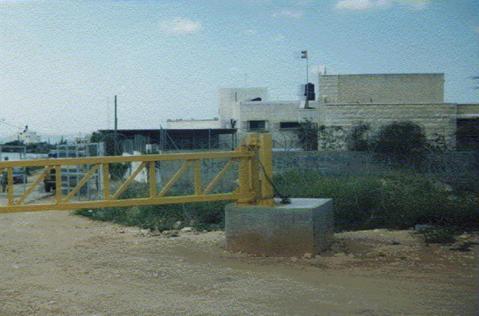
To the left is Ras Arira Wall gate and to the right is Ras Atiya Wall gate which remain closed most of time, Photos courtesy of LRC
It is important here to mention that the settlement Council took advantage of the effects of the establishment of the Wall and built new houses for settlers on the newly confiscated lands. Moreover, it has been documented recently that new inroads has been dug to connect these new houses with the already-established three settlements.
3. Psychological Effects:
-
The Israeli isolationist and racist policies have led to a noticeable upsurge of feelings of hatred and depression among Palestinians living nearby especially due to the daily Israeli practices on Israeli checkpoints. Moreover, the everyday view of the Wall in front of the eyes of the surrounded Palestinians is a source of distress and anguish.
-
The habit of Israeli soldiers and militarized units of gun shooting near the Wall between now and then generated feelings of fear and alarm in the hearts of Palestinians living nearby.
4. Educational Effects:
The isolation policies adopted by the Israeli government have led to an increased difficulty in student's transportation from the small surrounded communities to their high schools to finish their secondary education. Similar difficulties are faced by schoolteachers trying to access their schools in these isolated communities unless holding special permits which are sometimes refused by Israeli soldiers manning the gates. All such actions and behaviors have led to the impediment of the educational process. See Photo 4
A Wall gate limiting access to Ras Atiya school behind, Photo courtesy of LRC
5. Health Effects:
The adopted isolation policies have led to intricacy in delivering health services to the town and its associated sub-villages.
The Tour of LRC's fieldworker in the Town:
During the tour conducted by LRC's fieldworker in the town he met some Palestinian residents who were affected negatively due to the erection of the Wall. Those interviewed included:
-
Mr. Issa Abdullah Issa, a resident of Al Dab'a and works as a teacher in the town of Kafr Thuluth. He ended up having to find a residence in the town despite the fact that the school is less than 4 kilometers away from his village. That was due to the fact that the Wall isolates his village from its immediate environs and the fact that he has to get a special permit that might not be respected by Israeli soldiers.
-
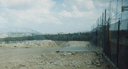
Mr. Abdel Aziz Qadoura Al A'araj, a farmer from the town of Kafr Thuluth. The erection of the Wall has led to the confiscation of 60 dunums of his land as well as the uprooting of 400 trees causing him to lose his main source of income, in addition to making him totally dependent on external assistance. See Photo 5

In the foreground: some houses of Kafr Thuluth. In the background: part of the confiscated and separated land of the town appears behind the Wall track, Photo courtesy of LRC
General Description of the Wall in the Town of Kafr Thuluth:
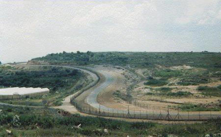
The total length of the Wall on the lands of the town of Kafr Thuluth is 8 kilometers. It consists of a number of trenches, barbwires, and electrified wires, in addition to an early warning network. The total width of the Wall is between 40 and 50 meters. It is worth mentioning here that the price tag of each 1 kilometer built of the Wall is NIS 1.0 million.
Kafr Thuluth- Qalqiliya: Wall fortifications and early warning systems, Photo courtesy of LRC
Anti- Wall Activities in Kafr Thuluth:
-
Conducting 4 anti-Wall demonstrations in which foreign and local solidarity movements cooperated with the residents of the town.
-
Establishing a number of websites about the Wall as well as preparing TV documentaries about the Wall and its effects on the Palestinian people in general.
-
Carrying out a number of visits by Members of the Knesset, members of the Palestinian Legislative Council as well as foreign supporting teams.
-
The formation of a local committee to face the effects of the Wall in the town and the nearby region.
-
Hiring a number of lawyers concerning the issue of regaining the confiscated lands.
The campaign and demonstrations are still going on, yet to no avail as the Segregation Wall snakes its way into the West Bank under the full awareness and knowledge of the international community.
Prepared by
The Land Research Center
LRC


