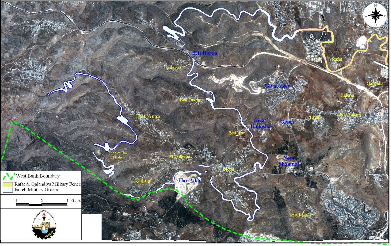
The three Palestinian villages: Beit Surik, Qattanah and Beddo are located some 12 to 16 Km northwest of Jerusalem. The villages form an agricultural triangle with an overall area that exceed 25000 Dunums (6250 acres) and extend over a series of mountaintops that over look Jerusalem city 12–15 Kilometers southeast. About 80% of the inhabitants of the three villages are dependent in their income on agriculture. The lands of the villages are cultivated mostly with citrus, grapes, almonds, and olive trees. The triangle villages are considered among Palestine's historical villages where they include within its' boundaries ruins of a historic Roman Church, a Byzantine relics and several hamlets and sanctified sites.
The atrocious Segregation Zone (Wall)
The year 2004 crowned the Israeli occupation attacks on the triangle villages of Beit Surik, Qattanah & Beddo when the earlier declared that the Segregation Zone and Wall would be constructed on lands of the villages. The actual barrier, which will be installed in the targeted area, is a segregation zone that will include 60-100 meters including a concrete wall, a metal fence, barbed wires, ditches and Israeli military road. The Segregation Zone will physically come on 12 kilometers (length) and will cut-off some 926 Dunums of agricultural lands from the triangle villages.
According to the Israeli military orders, concerning the route of the Segregation Zone and in conjunction with satellite images for the targeted area, the Segregation Zone will cross away from the residents houses a distance ranging between 40 to 100 meters in Beddo village and an even 10-meter in Beit Surik village. Furthermore, the Segregation Zone will run a distance ranging 600 to 1000 meters from the Green Line.. See table 1
|
Separation Fence & Seam Zone |
|||
|
location |
Km(L) |
Dunums |
|
|
Beit Surik |
4 |
308.8 |
|
|
Beddo |
6 |
462.6 |
|
|
Qattanah |
2 |
154.6 |
|
|
Total |
12 |
926 |
|
The impacts of the Segregation Zone once it is completed are far more severe and may be classified as a life threatening especially when it cuts off the agricultural lands from it's' owners and thus deprive them of their main and only source of income. The military fence will literally segregate thousands of Dunums belonging to the residents of the triangle villages, which they depend on for income and leave them to the mercy of a single iron gate as an access to their land. The only Iron Gate, which will be guarded by Israeli troops, is the main access of the villagers to their lands who will require a special permit to access the gate, a permit that will be given according to selective classification made by the Israeli Army. The following table shows the lands to be segregated by the Segregation Zone and its classification in addition to the lands to be utilized to put-up the Segregation Zone. See table 2
|
location |
Cultivated Land |
|
Beit Surik |
3600 |
|
Beddo |
2000 |
|
Qattanah |
480 |
|
Total |
6080 |
In addition to segregating the agricultural land in Beddo and Beit Surik, the two villages will lose control of their only water spring, which will be cut-off inside the military fence.
The Residents of the Triangle Villages Defend their Lands
In early February 2004, the Israeli bulldozers started to rout the tranquility of the villages when they bulldozed the cultivated land to set the path for the Segregation Zone. The residents of the three villages led united front non-violent demonstrations against the hard steel bulldozers and the Israeli Army that protected the monstrous machines. The residents also resorted to legal means to stop the mutation of their land and took their case to the Israeli supreme court of justice to stop the Israeli Army. The residents were able to obtain a court injunction to halt all work to the time when the court reaches a decision.
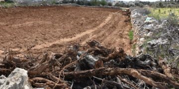
The Israeli Army retreated, only to resume bulldozing the land few days later and before the court had any saying on the subject. Photos of lands razed in Beddo and Beit Surik villages, Photo 1 & Photo 2

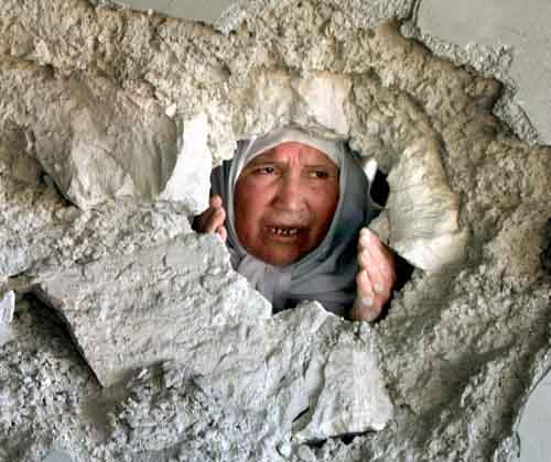
The Israeli Army disregard of the law and human rights is no stranger to the Palestinians who stood their grounds defending their lands again in non-violent demonstration, where the Israeli Army brutality resulted in three deaths of the demonstrators and the injury of 150 non-violent protesters.
The residents’ of the villages resorted to all means of non-violent measures to escape the horrible impact of the Segregation Zone; among which were the Israeli supreme court of Justice, the United Nations, and the Quartet committee, but all stood helpless against Israel not just against the three villages, but inverse an entire population.
Significant Events on the History of the Triangle Villages under Attack
1. Beit Surik
The village of Beit Surik with its 13,000 Dunums of agricultural land is inhabited by some 4000 people (571 families), most of whom (around 80%) are dependent on land cultivation for their income, while the built-up area in the village stretches over 250 Dunums.
Beit Surik village was among the hundreds of villages attacked and partially destroyed during the 1948 war by the Israeli occupation forces. In the 1967 war, the Israeli Occupation Forces (IOF) took control of the village and coerced more than half of its population out of their homes and lands. Ever since, the remaining residents of Beit Surik had to confront the Israeli occupation almost on a daily basis to maintain whatever left of their lands and protect it against the Israeli avariciousness. In the early eighties, the Israeli government declared approximately 1490 Dunums of Beit Surik agricultural lands confiscated for military purposes only to initiate in 1985 an Israeli settlement “Giv’at Har-Adar”. The Israeli forceful exploitation did not stop at that limit, as 10 years later it destroyed 1000 Dunums of Beit Surik fertile agricultural land along 2 Km to bed in sewage conduit for the Israeli settlement “Giv’at Har-Adar”.
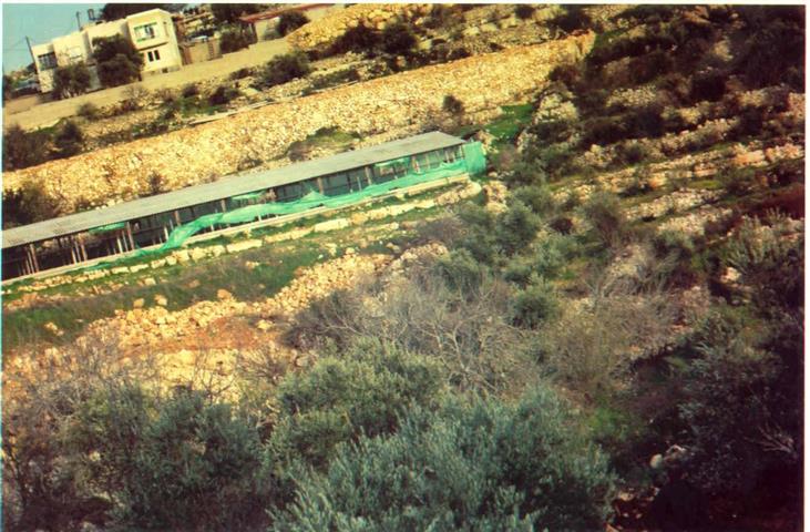
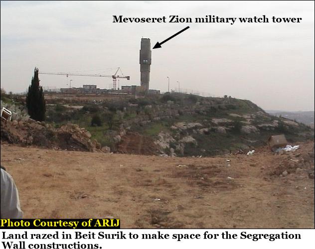
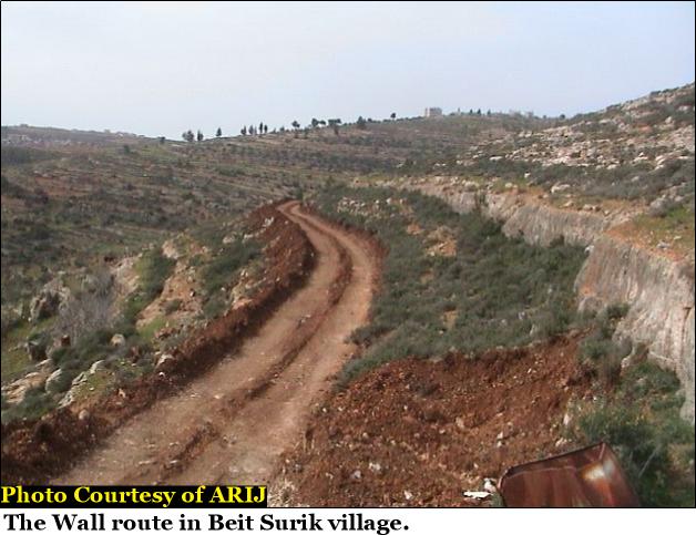
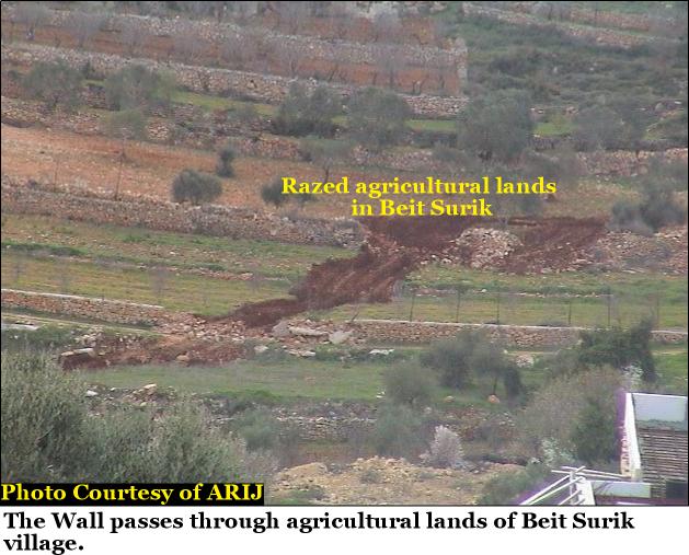
The systematic attack on Beit Surik reactivated again in early 2003 when Israel declared some 700 Dunums of Beit Surik land confiscated to construct security road along “Giv’at Har-Adar” settlement and concluded the year 2003 with additional confiscation order set to expropriate another 1000 Dunums of Beit Surik land as a part of the railroad Israel is intending to construct between Jerusalem city and Al-Lud city inside Israel in which, the residents of Beit Surik as well as the rest of the Palestinians will not be allowed to use. See photos of wall route in Beit Surik village, Photo 3 & Photo 4
2. Qattanah
The ten thousands inhabitants (1428 families) of this agriculturally based village are literally under immediate threat of evacuation and destruction of their village where the built-up area spread over 820 Dunums of the villages’ total area-5600 Dunums. In the year 1948, the Israeli militias attacked Qattanah village and destroyed it. Later on, 200 Dunums of the village’s land were identified as “No Man’s Land”; however, the residents refused to abandon their village and rebuild it once again in-spite of the Israeli governments’ threats. In 1967, the Israeli Army forced many of the village residents to abscond their lands and home in fear of their lives. The village became yet another victim of the Israeli viciousness and their village land subject of Israeli greediness. When the Israeli government laid out the plans to build a new settlement “Giv’at Har-Adar” right in the heart of the triangle villages, approximately 100 Dunums of Qattanah agricultural land was confiscated for the benefit of the settlement. In the year 2003, the Israeli Army confiscated additional 200 Dunums of Qattanah agricultural lands to construct a security road along “Giv’at Har-Adar” settlement. The railroad line to be constructed between Jerusalem and Al-Lud city inside Israel will approximately consume 600 Dunums of land once it is executed.
3. Beddo
This historic village was once formed of several Roman, Byzantine, Ottoman hamlets and sanctified sites, which ruins still exist to these days; it is located approximately 11 kilometers northwest of Jerusalem city on 6150 Dunums of agricultural lands (mostly olive trees).
The 7500 residents (1071 families) of Beddo are farmers (70%) whose lands were subject to Israeli targeting since 1948 when the Israeli militias completely destroyed the village. Later on, the village residents’ rebuilt and restored the village, where it stands today on a built-up area of 500 Dunums. Following the 1967 war, Israel initiated its colonial activities in the West Bank and as many Palestinian villages, Beddo had its share as Israel confiscated more than 400 Dunums of agricultural land for the benefit of the Israeli settlement “Giv’at Hadassha” (built in 1980). Apparently, the Israeli had much more in-store for Beddo residents when they slated down 950 Dunums of agricultural land from Beddo to build the Israeli settlement Giv’at Har-Adar in 1985. See Photos of destruction in Beddo village, Photo 5 & Photo 6


The following table shows the land confiscated by the Israeli occupation authorities and the dates of the events and purposes.
|
Confiscated lands since 1948 |
|||
|
Location |
Date |
Area/Dunums |
Purpose |
|
Beit Surik |
1985 |
1490 |
Giv’at Har-Adar |
|
|
1995 |
1000 |
Sewage line for settlement |
|
|
2003 |
700 |
Security Road for settlement |
|
|
2003 |
1000 |
To Develop Railroad (not built) |
|
Total 4190 |
|||
|
Qattanah |
1948 |
200 |
No Man’s Land |
|
|
1985 |
100 |
Giv’at Har-Adar |
|
|
2003 |
200 |
Security Road for settlement |
|
|
2003 |
600 |
To Develop Railroad (not built) |
|
Total 1100 |
|||
|
Beddo |
1980 |
800 |
Giv’at Har-Adar |
|
|
1985 |
950 |
Giv’at Hadassha |
|
Total 1750 |
|||
|
Total Dunums Confiscated |
11440 |
|
|
Prepared by:
The Applied Research Institute – Jerusalem