Movies of Bethlehem district (Satellite & 3D), and a 3D-West Bank movie presenting the Segregation Wall borders.
- Introduction
- Segregation wall.
- The Segregation Wall that envelopes Jerusalem
- The annexation of Bethlehem's Rachel Tomb to Israel
- New Israeli settlement outposts
- Israeli military checkpoints
- House demolition
- Growth of Israeli settlements
- Settlers population growth
- Financial incentives for Israeli settlements and settlers
- Movies of Bethlehem district ( Satellite, 3D-Bethlehem), and the West Bank presenting the Segregation Wall borders.
1. Introduction
After the Madrid conference initiated in 1991 and later the Oslo Accords, which collapsed in September 2000 after the start of the second Intifada, several initiatives were primed to resolve the conflict. The current initiative is the ''Road Map'' that was issued on June 2002 by the Quartet (United States, Russia, EU, and the UN). The Road Map states that the Israeli leadership should issue statements affirming its commitment to the two-state vision of an independent, viable, sovereign Palestinian state living alongside Israel as expressed by President Bush. The Road map states also that the Government of Israel should take no actions undermining trust, including deportations, attacks on civilians, confiscation and/ demolition of Palestinian homes and property.
Following Al-Aqaba summit that took place in Jordan on June 2003, and was closed with the four leaders (President of the United States George Bush, King Abdalla of Jordan, Israel's Prime Minister Sharon and Palestinian Prime Minister Abbas) statements to end the 32-month violence and until recently, the Road Map has not yet come with fruitful results, and violence is still taking place, on the ground, Israel continued expropriating Palestinian land, expanding Jewish settlements, building new Israeli bypass roads, and constructing segregation walls and zones, casting doubt on Israel's genuine aspirations for a resolution to the Israeli – Palestinian conflict, on the other hand, the Palestinian government has tried its best to control the anger of the Palestinian people and the militant groups reactions to the Israeli violations.
The report will highlight the latest Israeli colonization activities in the Palestinian Territories that contradict with UN resolutions, International Laws, the peace efforts and the Road Map.
2. The Segregation Wall
'A Wall looping like a snake in the Palestinian Territories is a problem that made it very difficult to develop confidence between the Palestinians and Israel'' was President George W. Bush criticism to the Israeli Segregation Wall being erected inside the Palestinian West Bank during the Palestinian Prime Minister Mahmoud Abbas visit to Washington on July 25, 2003. The Wall is not only swallowing the Palestinian lands and natural resources and destroying the Palestinian environment and landscape, but it is destroying the Palestinian cultural heritage, social life and economy and causing suffering to thousands of Palestinian citizens in a very repulsive way.
The Israeli Government started on June 16, 2002, the construction of a massive Segregation Wall between the West Bank and Israel. The Segregation Wall is currently being built on Palestinian land east of and parallel to the 1948 Armistice borders, the so-called Green Line. The Green Line, which forms the border between the West Bank and Israel, is approximately 360 kilometers in length. The path of the Segregation Wall is designed to enfold and annex all Israeli settlements, valuable Palestinian agricultural lands and groundwater resources within the West Bank east of the Green Line. Since June 2002, the Israeli government has been hanging military requisition orders on trees at Palestinian lands and farms on the Palestinian side of the Green Line, declaring these lands the property of the State of Israel.
The erection of the huge concrete wall is another Israeli policy to confiscate more Palestinian lands and not a rationale for the security of Israeli citizens as the Israeli government claims, but it comes as a result of a long-termed Israeli plans and land grab policies to control the Palestinian Territories. If the intention is security the Segregation Wall should have been erected at the Green Line, which separates the Occupied Palestinian Territories from Israel on the borders recognized by the International community after the occupation of the West Bank in 1967. Therefore, the Israeli attempts to annex any occupied Palestinian territory or change the 1967 borders are illegal according to United Nations resolutions 242 / 478 / 497, and contradict with International Laws, the basis of Madrid conference for Peace and the Road Map designed by the Quartet and not accepted to Palestinians and to the International Community.
The first phase of this Segregation Wall is 123.3 km long and around 100meters wide and has been completed from the village of Salem located at the upper north of the West Bank to the village of Masha and Elkana settlement located on Palestinian lands within the governorate of Salfit. The Segregation Wall penetrates the West Bank in certain areas to depths that reach 6 to 7 kilometers. The area of Palestinian lands trapped between the Green Line and the Segregation Wall in phase 1 is 102.5km2 and constitutes the most fertile agricultural lands of the West Bank. This area is 35.4 km2 and contains over 701 thousands of bearing trees and is known to be the Palestinian food basket as it is planted with a variety of fruit trees, vegetables and crops. See Table 1.
Those trapped Palestinian lands are also located on the Palestinian western water aquifer that contains 30 artesian wells and supplies the West Bank with over 3.54 million cubic meters of water each year. In addition that during the implementation of phase 1 of the Segregation Wall, a large number of Palestinians green houses were damaged and others were removed as a result of its construction.
Table 1: Agricultural lands and trees segregated from the West Bank behind the Segregation Wall in Phase 1, 2003
|
Type of Plantation |
Land area (in Dunams) |
Number of trees |
|
Fruit trees (mainly olives) |
29231.8 |
701563 |
|
Field crops |
3162.6 |
— |
|
Vegetables |
3074.8 |
— |
|
Total |
35469.1 |
701563 |
Source: ARIJ, GIS database, 2003
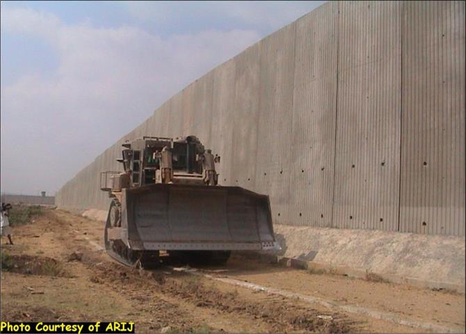
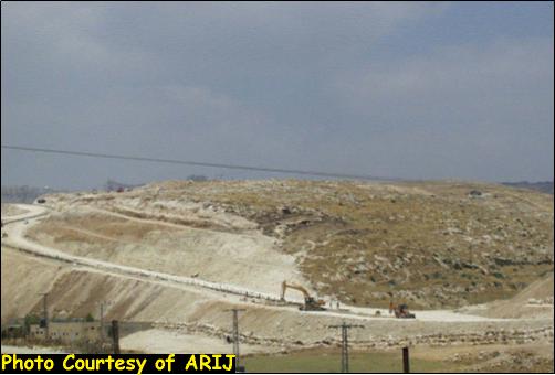
Figure 1: The Segregation Wall 6-8 meters high west of Qalqiliya city, 2003

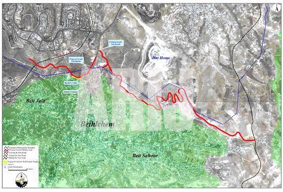
Figure 2: The Segregation Wall north of Bethlehem city, ARIJ, August 2003
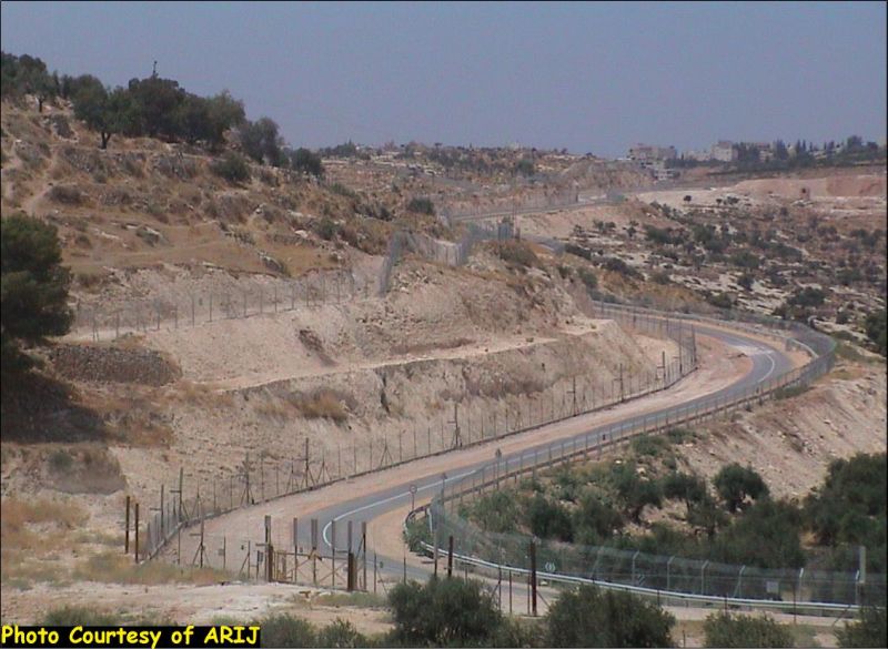
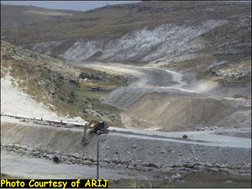
Figure 3: Work continues in the Segregation Wall East of Beit Sahour, Bethlehem Governorate, ARIJ, August 2003
 x
x
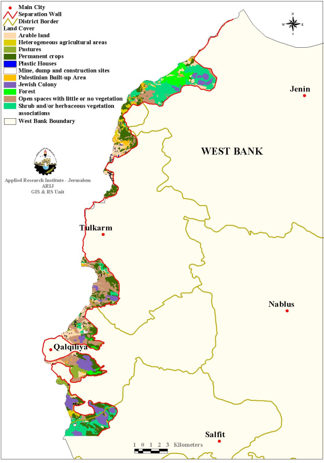
Map 1: The Segregation Wall Phase 1, northwest of West Bank, 2003
Agricultural Palestinian lands in the West Bank segregated west of the Segregation Wall
The Segregation Wall encloses 15 Palestinian villages with more than 12000 Palestinian citizens who were cutoff of their trade centers, education, health and all other civil services in addition to 69 villages with 217837 Palestinians who became affected as a result of segregating their agricultural lands and countryside at the other side of the Segregation Wall. Living in enclaves created by the wall, the Palestinian citizens especially the farmers have been severely affected, their social life has been damaged and their economic condition has worsened to an alarming level where unemployment rate has reached over 72%.
The arising new situation and the harsh living conditions will result in forceful migration and ethnic cleansing to thousands of Palestinian families that are left without any source of income or support. Access to the lands became extremely difficult and farmers require special permits in order to enter their farms through the limited number of gates opened in the Wall. The Palestinian farmers have to travel 3 to 5 kilometers through many Israeli checkpoints in order to reach the nearest gate which is guarded by Israeli soldiers. The gates open for one hour in the morning from 6a.m to 7a.m, which is a late and a short time for farmers who used to be at their farms even before sunrise in order to collect their harvest and bring it to market in the early morning, in addition that those gates open again for two hours in the evening from 6.00p.m to 8p.m and farmers are not allowed to sleep in their fields.
In most cases as in the governorates of Tulkarm and Qalqiliya, the way to the markets is obstructed by many Israeli checkpoints and farmers have to wait for long time in order to pass-through, or have to take long routes that are usually obstructed by road blocks and the farmers are obliged to transfer their yield from one vehicle to another at each roadblock in order to transport their yield to trade centers. Reaching market after all the suffering and even humiliation by the Israeli soldiers, the yield is becoming limp and spoiled, and the farmers have to go through another process of suffering in order to sell their harvest. If the area becomes under curfew or siege, the farmers will not be able to reach their farms or markets and their yield is damaged.
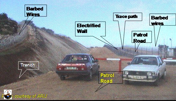
The components of the Segregation Wall spread over a width of 40 to 100 meters as indicated in the requisition orders. These components, from east to west, include several attached loops of barbed wires, a trench creating an obstacle against Palestinian vehicles, a dirt path with forbidden access to constitute a 'killing zone', a 3 meters high warning electric fence built on a 1 meter concrete wall, a trace path to disclose the footprints of infiltrators, a two-lane patrol road and another set of barbed wires (figure 4). Opposite to the Palestinian city of Qalqilya, the concrete wall has a height of 6 to 8 meters and contains military control towers every 200 meters (figure 1). The wall surrounds the city of Qalqiliya almost completely, making the city as an object inside an open jar, but leaving one entrance to the city from the eastern side with a width of about 100 meters. This arrangement is imposed on other Palestinian urban centers east of the Segregation Wall such as Tulkarm.
Data available at ARIJ show that the first phase of construction of the Segregation Wall h is almost completed in the northwestern part of the West Bank. See Figure 4
Another fenced wall (depth wall) has been planned along certain parts to the east of the Segregation Wall in addition attached enclaves for many villages located in the West Bank adjacent to the 'Green Line' borders (see map2 of the segregation wall). In this regard, some military orders were issued and trenches were dug in some areas located along the depth wall path.
The Israeli aggression on Palestinian land to build the Segregation Wall is not solely based on security reasons, as the Israeli media and government claim. In addition to the checkpoints, roadblocks and other physical barriers their plan entails, the Segregation Wall is intended to separate Palestinian localities from each other and inhibit or completely freeze the economic, political, educational, medical, and social service activities necessary for a healthy society. Not only are vast areas of land threatened with confiscation, the Segregation Wall threatens crucial supply areas containing artesian wells and main water basins that provide the West Bank with water.
Implementation of demolition campaigns entailed in construction of the Segregation Wall spells disaster for Palestinians living in the West Bank, particularly for those who live in the villages near the Green Line. The economic consequences for the West Bank will also be severe. The Israeli policy behind such actions is to reduce as much possible the number of Palestinian citizens living in the areas between the Green Line and the Segregation Wall. The Israeli policy involves the illegal annexation of large areas from the OPT and more housing demolitions in addition to the homes which have already been destroyed. Israel's unilateral plan of segregation will sharply reduce the number of Palestinians living in these areas.
The segregated 15 villages in the Jenin, Tulkarm, and Qalqiliya districts have a population of more than 12000 inhabitants. These villages are imprisoned between the Green Line and the Segregation Wall. Many villages have no social services except for some small retail shops, and they are mostly dependent on nearby villages and small towns.
Educational and health facilities are non existent in most villages. Some villages have elementary schools but only one has a secondary school. Health facilities are rare at the village level. The few health clinics and pharmacies such as in Barta'a ash Sharqiya in Jenin district and Baqa ash Sharqiya in Tulkarm district are the only exception. Once the villages are totally segregated behind the Wall, the villages will become part of a closed military area as defined by the Israeli government and the villages daily life will be become a nightmare. Access of children to elementary schools and students to secondary schools or universities will be extremely difficult. Transfer of sick persons to hospitals will be also difficult and risky. Entrance to those areas by Palestinian ambulances will require special permits from the Israeli military forces, which will cause time delays and human life in cases of emergency will be endangered.
The nearest hospitals to the segregated area in the Jenin district are located in the city of Jenin. Jenin hospital is administered by the Palestinian Ministry of Health and Al-Shifa Hospital is privately administered. The distance from the segregated area to the city of Jenin is about 20 km. In Tulkarm district, the Tulkarm hospital is the only hospital and is located in the city of Tulkarm. This hospital is administered by the Palestinian Ministry of Health. In Qalqiliya district the UNRWA hospital is the only hospital and is located in the city of Qalqiliya. Access to the city of Qalqiliya will be extremely difficult as the city will be almost surrounded by the Segregation Wall, and access to it from the neighboring villages segregated to the western side of the Wall, or even from the Palestinian communities on the other three sides of the wall will be almost impossible (see the delineation of the wall around the city of Qalqiliya).
Bethlehem district shares similar problems, the Wall that is recently under construction around the northern part of Bethlehem city will deprive the Palestinian citizens from free movement to the city. Like the Palestinians in the north of the West Bank, Palestinians in Bethlehem district will be unable to go about normal daily activities.
Furthermore, the social relationships between the imprisoned inhabitants of the segregated areas will be severely disconnected as the segregated areas are declared closed military zones, whereby Palestinian citizens on the Palestinian side of the Wall will be forbidden to enter that area and family ties will be disrupted.
Approximately 70 villages or localities are also affected by the Segregation Wall because their lands are seized or confiscated for the construction of the Wall. This means these villages have no meaningful opportunity for future urban expansion and no open spaces. Many of these villages are also dependant on agriculture as a main source of income. See Map 2 & Map 3 &
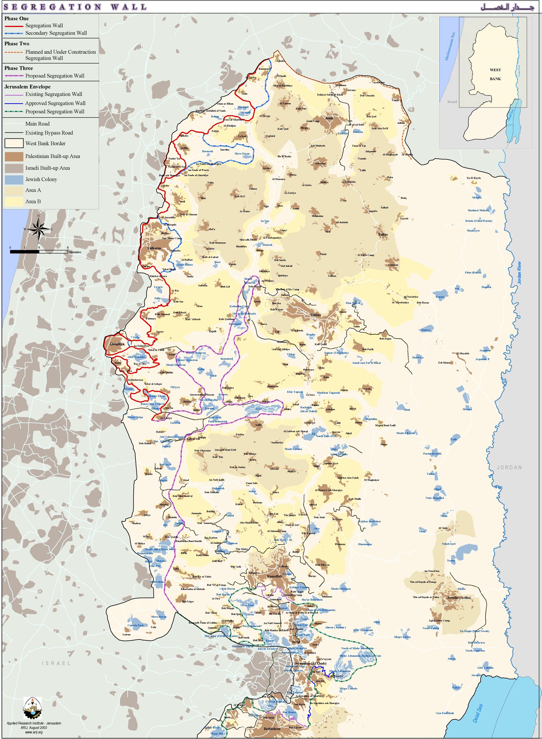

Map3: shows the area of land confiscated from the villages east of the Segregation Wall, which will lose a part of their land for the construction of the Wall.
The Segregation Wall – changes its direction to grab more Palestinian Land
The Israeli Occupation Forces -IOF- are daily changing the path of the Segregation Wall that is currently under construction in the northern districts of the West Bank and around East Jerusalem. The change of this path always costs the Palestinians more land and provides more facilities especially to the settlers.
The IOF issued a map in March 2003 concerning the path of phase I of the Segregation Wall. This map shows tragic changes on the ground especially to the villages of Habla, Ras 'Atiya located to the south of the city of Qalqilya and Qaffin that is located to the north of Tulkrem. According to the route of the Segregation Wall approved in August 2002 Qalqilya, Habla and Ras 'Atiya are found in one 'Ghetto', while as it can be analyzed from the new map provided by the IOF, that the villages of Habla and Ras 'Atiya will be disconnected from the main city of Qalqilya and will be obliged to make a round trip to reach the city. The reason behind this change is that the settlers (about 2,500) living in the settlement of Matan strongly opposed to the old route of the Wall; their main concern is that the settlers of Alfei' Menche will be using a new road that passes through Matan. So, after a long pressure the Israeli Authorities decided to keep the main road that leads the settlers of Alfei Menashe to Israel open and enclave around 6,700 residents of Habla and Ras 'Atiya rendering isolated from their mother city that is Qalqilya. See Map 4
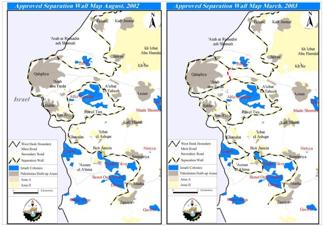
Map 4: Changing the alignment of the Segregation wall
Another fact is that an additional or secondary wall will imprison 21 Palestinian localities into 6 'Ghettos' in the area between the main Segregation Wall and this new secondary wall which will create enclaves as in the case of Qalqiliya where the wall turns into a shape of a bottle.
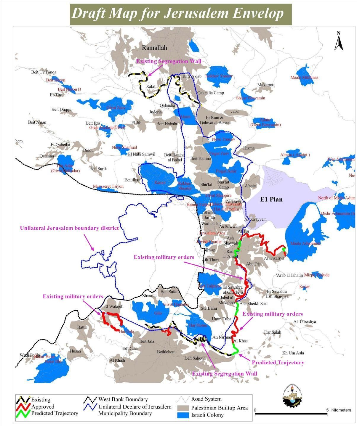
2.1 The Segregation Wall that envelopes Jerusalem
The southern part of the Segregation Wall
The Segregation Wall that surrounds Jerusalem, the Israeli so-called Jerusalem Envelope is also under construction along the northern and southern borders of Jerusalem. To the north of Bethlehem, the Segregation Wall has a length of 15 kilometers. It is segregating more than 15 thousand dunams of Palestinian agricultural lands planted mostly with olive trees and belonging to Palestinian citizens living in Bethlehem area. Unilateral separation and walls ensure that Occupied East Jerusalem is completely sealed off from the rest of the Occupied West Bank.
Creating facts on the ground or unilateralism drastically changes the parameters of a permanent solution to the Israeli-Palestinian conflict. Israel's expansion of Jerusalem's illegal boundaries is one example of such de facto policies that aim to augment the course of the negotiations over Jerusalem. Prime Minister Ariel Sharon's old-new plan to separate the city of Jerusalem from its Palestinian neighborhoods is a plan in progress.
Israel's policy of creating facts on the ground has increased since April the 1st 2002 invasion of the Bethlehem district. A number of Israeli confiscation orders were issued and handed out to Bethlehem, Beit Jala and Beit Sahour municipalities. It is significant to note that this buffer is built solely for political reasons, ignoring the implications of such action on Palestinian geographical contiguity. Also, confiscation of land for Israeli military purposes will have negative consequences on the Palestinian communities and their economy. Bulldozing the land has resulted in the uprooting of hundreds of olive and apricot trees, as well as the diminution of Palestinian agricultural land. Many Palestinians depend on the crops and the products of the olive and apricot trees. Depriving these families of this source of income will have a negative effect on their economic situation.
The most threatening aspect of establishing the buffer zone around Jerusalem is the annexation of Palestinian neighborhoods such as Bir'Ona, a part of the town of Beit-Jala. Bir'Ona is a Palestinian neighborhood of around 1,000 people, located southwest of Beit Jala. Israel has always tended to annex Bir'Ona, which comprises 29% of Beit Jala total area, towards the Jerusalem boundaries. Jerusalem Municipality planned to compel the house owners to apply for building permits from the municipality of Jerusalem in an attempt to annex Bir'Ona boundaries to Jerusalem. On January 22 ,1999, the Jerusalem Municipality declared its intention to annex Bir'Ona by putting the village under its jurisdiction and levying Israeli tax known as 'Arnona' on its Palestinian inhabitants. Today, the wall is already erected on northern part of that neighborhood.
Israeli attempts to change the geographical and the demographical shapes of Jerusalem either by altering its boundaries or separating it from its Palestinians neighborhoods. Any final talks between the Palestinians and the Israelis regarding Jerusalem will be further complicated by the violations committed by the Israeli government in creating more facts on the ground to reinforce its control over the negotiations with Palestinians.See Map 5
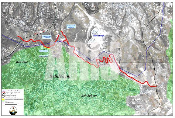
Map 5: The segregation Wall north of Bethlehem
2.2 The annexation of Bethlehem's Rachel Tomb to Israel
Rachel's tomb, located at the northern part of Bethlehem, is considered a pilgrimage place for Christians, Muslims and Jews. Rachel, the wife of Jacob, died in childbirth on the way to Hebron and was buried on the road to Bethlehem. The Tomb was neglected for many years until the Crusaders rebuilt it. The simple building which now houses the tomb was erected by the Turks in 1620 during the Ottoman period. Muslims considered the place sacred for its relation to Abraham and thus kept its keys. Rachel's Tomb is one of Bethlehem's historical sites and a part of the city's heritage. In the past two years, the Israeli occupying forces have prevented Christians and Muslims from visiting the Tomb, thereby denying the Palestinians right of worship and limiting the shrine to Jewish groups in a primary step to annex the Tomb to Jerusalem.
According to the Oslo II Agreement signed in 1995, the location of Rachel's Tomb falls in area C of the Bethlehem district, i.e. under temporary Israeli security and civil control. The Palestinians retain the right to use the main road. Area C was supposed to be transferred to the Palestinian Authority (PA) within 18 months of the inauguration of the Palestinian legislative council. The Oslo II Agreement, Annex 1, Article V, section 7 states: 'The present situation and existing practices in the Tomb shall be preserved'. See Map 6
Map 6: The wall at the northern entrance of Bethlehem near Rachel's Tomb
On September 11, 2002, the Israeli security cabinet approved a plan to keep Rachel's Tomb under Israeli control by including the Tomb behind the Segregation Wall (map 6).
Rachel's Tomb has always been a part of Bethlehem, and a pilgrimage place for people of the three monotheistic religions. Today the Tomb is becoming a military camp and is open only for Jews. The Israeli government plans to annex the Tomb to Jerusalem will cost Palestinian citizens of Bethlehem – Chrisians and Moslems – precious parts of their land, homes and heritage that they have conserved throughout history. Such Israeli policies also damage the tourist industry in Bethlehem, as well as the Palestinian economy in general.
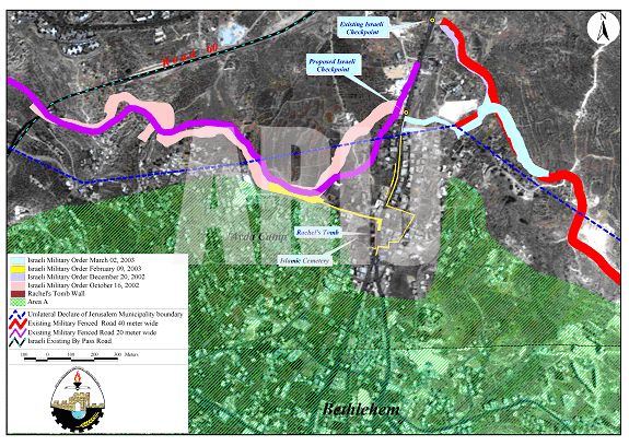
On Februrary 9, 2003 Mosheh Kaplenski, Chief Commander of the Israeli Occupation Forces in Judea & Samaria, issued military order number (03/14/T Judea & Samaria 2003)to seize land in the North of Bethlehem to construct the Wall that will enclose and annex Rachel's tomb vicinity to Jerusalem. The map that the Israeli Occupation Forces (IOF) put at the residents' disposal shows that only 18 dunums will be seized and confiscated, but Israel will actually segregate around 3000 dunums of land behind the Wall.
Kaplenski classified in the order, the parcels of land that are to be seized, with no other explanation than 'military reasons'. He also declared that the Israeli Occupation Forces (IOF) have an 'absolute control over it'. The wall will physically separate the city of Jerusalem with its two parts, east and west, from the West Bank.
On the 16th of February 2003, the IOF handed the residents military orders that are showing the plan to strangulate the city of Bethlehem by confiscating its northern entrance and annexing it to Israel. Forty residential buildings that house 500 people, a small industrial complex, a gas station and commercial shops will be isolated in this zone (any person will need a permit to visit them) and therefore forced to leave.
The municipality of Bethlehem city went to the Israeli Supreme Court in order to revise the military order that was issued in February 2003. The municipality also tried to explain the issue to different international organizations by showing the disadvantages of erecting such a Wall at the main entrance of the city. The answer was given 6 months later by giving a new map for the area. An updated plan was issued August 2003, the new map shows that there are changes on the ground but the wall itself will be erected. A number of 60 people will be enclosed inside this wall, that will segregated from Bethlehem city and to have limited movement while going out of this military zone and coming to it. See a 3-D representation of the Wall.

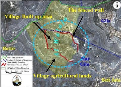
On August 12, 2003, a military order no.03/44/T was issued by Gadi Ezinkot, the Israeli Commander of Yehuda and Samaria region, ordering the annexation of 23.8 dunams of land belongs to Palestinians from AL-walaja and Beit Jala residents. The claim behind this seizure was as usual for 'security needs', The route of the land being seized is clearly showing the intention behind such violation; to circulate Al Walaja village as a part of the so called 'Jerusalem envelope''. A military fenced road will circulate the village from its four sides and limits the possibility for any natural expansion; moreover, it will imprison the inhabitants in a new ghetto, (see satellite image); thus, isolating the northwest part of the village which is close to the Israeli illegal boundary of Jerusalem. ); thus, isolating the northwest part of the village which is close to the Israeli illegal boundary of Jerusalem. See Map 7
The Eastern part of the Segregation Wall in Jerusalem:
One of the most alarming issues in the Eastern part is the two villages of Al-Khas and Al-Nu'man that are located close to the border of the city of Jerusalem according to the Israeli definition of these borders. The villagers of Al-Nu'man especially are living a daily threat because the construction of the separation wall is taking place not far away from their village. By the 22nd of July 2003 the IOF issued new military orders to complete the section of the wall that corresponds to the area near Beit Sahour isolating Al-Nu'man village from Bethlehem district.
The new military orders are corresponding to three sections of the wall; the first section is extending from Al-Nu'man village reaching to Sur Baher in Jerusalem. The second section is a small spot near an area called Al-Sheikh Sa'ad and the third section is coming from the Jerusalem University of Abu Dis reaching near the Legislative Council office in Abu Dis.
|
N0 of Military order |
Issue date |
Region |
Area seized in Dunums |
|
03/47/T |
21/7/2003 |
Al-Sheikh Sa'ad |
1.5 |
|
03/48/T |
21/7/2003 |
Abu Dis |
42.6 |
|
03/49/T |
21/7/2003 |
Al-khas & Al-Nu'man |
134.5 |
|
03/52/T |
7/8/2003 |
Ezeria (Bethany) |
202 |
|
03/53/T |
7/8/2003 |
Ezeria (Bethany) |
105 |
|
Total |
|
|
485.6 |
Map 8:: The Segregation Wall and the newly issued Israeli military orders around Jerusalem
Source: ARIJ, August 2003
The Northern Part of Jerusalem Envelope
The Segregation Wall that surrounds Jerusalem, the Israeli so-called Jerusalem Envelope is under construction along the northern and southern borders of Jerusalem. To the south of Ramallah, the Segregation Wall has a length of 8 kilometers. By the 15th of August 2002 a military order was issued to construct a 'Security Barrier', that is the Segregation Wall, to the north of Jerusalem municipality border. This order was issued according to the emergency law of 1949 for land seizure, and since then- August 2002- the land is under the control of the Israeli army.
This order is a violation to the Israeli laws as the area mentioned in the military order is annexed to the Israeli municipality of Jerusalem and obeys the civil law not the military law. However, the Israeli Authorities explains that the army is taking control over the lands in that area due to urgent security reasons. The work to erect the corresponding part of the Segregation Wall around Jerusalem started on the 22nd of August 2002 at the village of Rafat.
The part of the fenced Segregation Wall in Ramallah is now expanding over the lands of villages located to the North of the district. The villages are: Al-Ram ( Khalet el Sheikh), Qalandia, Kufr Aqeb, El Bireh ( Rafat al Massioun) and Rafat. The length of this new barrier is 8 Km, with a width ranging between 40 to 100 meters. The area of the isolated lands is 500 dunums, and another 300 dunums will be a military restricted area as a security zone along the path of this barrier. See Map 9
Effects of the Wall:
1- The spatial analysis reveals the following facts when the Segregation Wall plan is fully implemented at the northern part of Ramallah district:
2- Around 15,000 Palestinians holders of Israeli IDs from Qalandia town, Qalandia refugee camp and Kufur Aqeb will be enclosed between the new barrier and Jerusalem municipality border. The residents will be paying the taxes as the other Israelis but will not be receiving the same facilities and services as they will be staying in a special security zone.
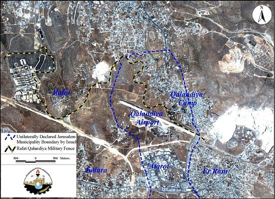
3- Qalandia airport will be annexed and totally controlled by the Israeli Authorities. This act is considered as another violation to the Oslo II agreement that mentions the transfer of this airport to the Palestinian Authority by the final status solution. See Figure 5

4- The erection of this fenced Wall to the north and to the east of Qalandia's cross road means that there will be a new border adjustment to the municipality of Jerusalem and consequently a new step toward the enlargement of Jerusalem municipality boundaries. See Map 10

Map 10: Metropolitan Jerusalem Plan
5- Because of the Wall, lands that belong to the villages located to the north of Ramallah are confiscated. Some of these lands are Agricultural and the rest are useful for urban expansion. This act has therefore limited any future urban expansion for those villages. See Figure 6

6- The separation of East Jerusalem from its Palestinian media of the West Bank is paralyzing its commercial, industrial and tourism activities.
7- This barrier will limit the right of free religious worship in the city of Jerusalem for Muslims and Christians living in the West Bank.
8- The Segregation Wall expands to the west causing the separation between the residents of the village of Rafat and their lands that are located to the south and to the west of the village, in spite of the fact that Rafat lands are located within the West Bank Boundaries.
9- In addition, the Wall encloses the lands and the village councils of Qalandia, Judeira, Beir Nabala and Al Ram villages which belong to the West Bank, but will be found in a security zone. The implications of the security zone will be horrible to those people who are holders of Palestinian IDs, as they will be deprived of their free movement, and will not have the right to build new houses, therefore will be endangered indirect migration.
10- Near the village of Rafat a by-pass road along with the fenced Segregation Wall is creating a security zone of 600 dunums. The land in this zone is planted mainly with olive trees. Bitunia military camp that is close to the village seizes a land of 800 dunums.
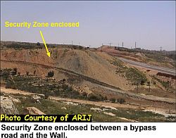
11- The total area of Rafat village is 4580 dunums, after the land confiscation for different Israeli security and military purposes the village is left with about 330 dunums of land. Meaning that Rafat village will loose 75% of its original lands. See Figure 7 & Figure 8 &

3. New Israeli settlement outposts
The question of dismantling the outposts erected at the top hills of the West Bank gained a lot of interest and media coverage, while the efficiency of this dismantling process was never achieved. Since the Aqaba summit till today only 8 outposts were dismantled according to Peace Now fieldworkers, while 12 new outposts were erected 4 of which were dismantled. So the settlers reached to maintain the same number of outposts in the Occupied West Bank and even developing the infrastructure of some existing outposts.
The Israeli Knesset took a decision by the 22 of July 2003 to dismantle all 'unauthorized' outposts. While in reality no real action was taken by the Israeli army to dismantle those illegal colonial spots- according to the international law- that should take no more than one hour for each to be dismantled. However if there is a military order to demolish a Palestinian home we can observe clearly the Israeli bulldozers moving rapidly to the site and razing all what is above this Palestinian sign of existence.
According to Peace Now the number of newly erected outposts is 8 which are the ones who remained from the 12 newly erected outposts after the Aqaba summit by the 3rd of June 2003. Those outposts are:
Outposts established after Aqaba summit 3rd of June 2003 and still exist
|
|
Outpost name |
Location |
Number of structures |
|
1 |
Hill Imbalin |
South East to Ma'aleh Michmas |
1 container
|
|
2 |
Hill 777 |
West to Kochav Hashahar |
1 container |
|
3 |
Kochav Hshahar South |
Hill South to Kochav Hashahar |
1 container |
|
4 |
|
Hill Southeast to Kochav Hashahar |
1 container |
|
5 |
Hill # 804 |
East to Shvut Rahel |
8 containers ( inhabited) |
|
6 |
Ofra Southeast |
Southeast to Ofra |
1 container |
|
7 |
Hill 652 |
West to Bat A'in |
1 container |
|
8 |
NT 840 ( Jabal Tantur) |
Hill between Shilo and Elit |
2 containers ( not inhabited) |
The other outposts that were established after the Aqaba summit and then dismantled are the following outposts:
New outposts established after the 3rd of June 2003 and dismantled
|
|
Outpost name |
Location |
Number of structures |
|
1 |
Skali ( East Elon Moreh) |
600 -700m East Elon Moreh |
1 container |
|
2 |
Rechalim East |
South to Rechalim |
1 container |
|
3 |
Revava West |
West to Revava ( north to Ariel) |
1 container |
|
4 |
Giva't Ariel |
South to Yetzhar |
Container |
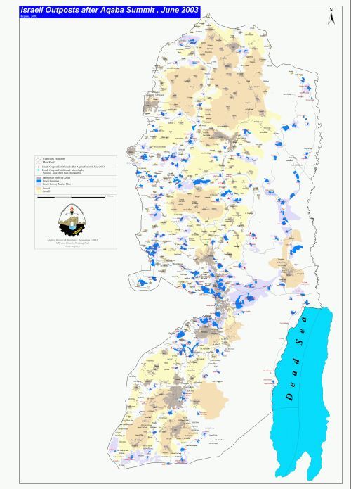
Map 11: Location of new Israeli outpost after Aqaba Summit
In addition, some of the already existing outposts in the West Bank are submitting infrastructure works such as to connect into electricity as the Outpost of Neve Daniel North that is in the Bethlehem district and also the outpost of Gilad Farm that was supposed to be dismantled is having additional 4 containers.
The Road map plan proposed by the USA and the Quartet stresses on freezing all settlement activities in the Occupied Palestinian Territories-OPT- of the West Bank and the Gaza strip, during the time that these activities are increasing daily. As a result, the violations to the Road Map by the Israeli side are taking place daily. In addition all colonial and settlement activities are illegal according to the international law and the fourth Geneva Convention which mentions that the occupying power is not allowed to transfer a part of its population into the occupied territories. See Figure 9 & Figure 10


From left to right (New outpost – Ofra , New outpost – Eli)) , New outpost – )
New Israeli erected settlement Outposts on Palestinian Lands in the West Bank
4. Israeli military checkpoints
For the past two and a half years, the Israeli Occupation Forces erected more than 190 checkpoints and roadblock all through the main and secondary roads of the West Bank. These checkpoints divided the Palestinian cities and villages into cantons and made it very hard for people to move and to maintain a normal life. Recently, and upon the understanding between the Palestinian National Authority and the Israeli government, a total number of 12 of 197 checkpoints and earth mounts have been removed in the West Bank. See map of checkpoints.
Three checkpoints or road blocks were removed from Bethlehem district, another three in Ramallah, two in Jenin district, four in Qalqiliya, and one between Ramallah-Nablus main road. Despite the fact that the removal of these roadblocks supposed to ease the movement of thousands of Palestinian villagers and passengers, it remains that around 185 roadblocks and checkpoints scattered all around the West Bank deprive hundreds of thousands of Palestinian from the right of freedom of movement, the right to work, the right to health and to education. See Map 12
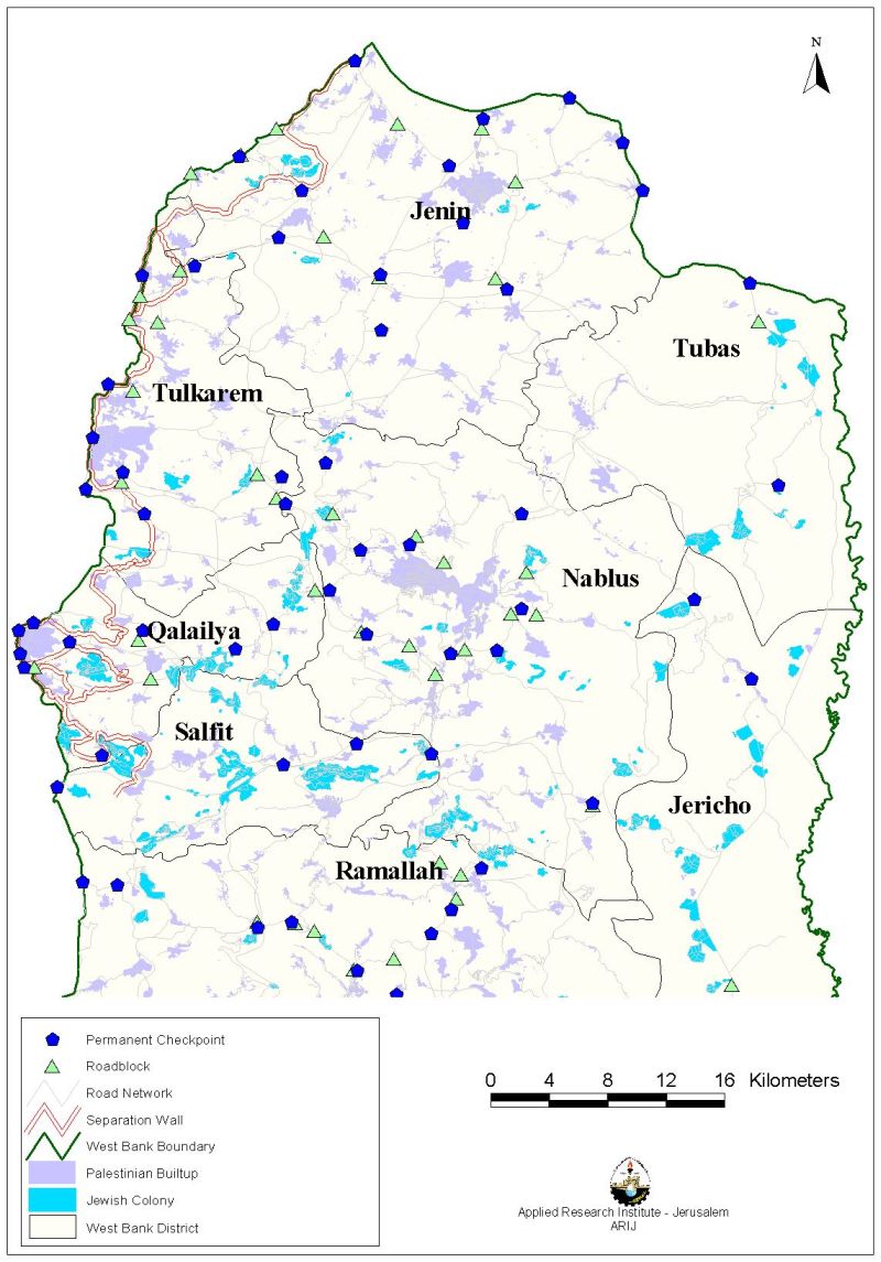
Map 12: Israeli checkpoints int the Northern Part of the West Bank
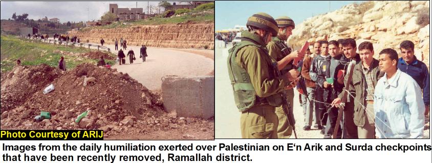
Figure 11: : Human Suffering at checkpoints
The following table gives the numbers of checkpoints and roadblocks in the West Bank including those which have been removed recently.
|
District |
Barriers Removed* |
Number of Israeli barriers |
||
|
Army checkpoint |
Road block |
Iron gate |
||
|
Nablus |
– |
11 |
11 |
– |
|
Jenin |
2 |
13 |
9 |
2 |
|
Tulkarem |
– |
8 |
8 |
– |
|
Qalqiliya |
4 |
1 |
5 |
5 |
|
Tubas |
– |
2 |
1 |
– |
|
Jericho |
– |
7 |
8 |
– |
|
Ramallah |
3 |
26 |
20 |
|
|
Bethlehem |
3 |
9 |
13 |
2 |
|
Hebron |
– |
21 |
24 |
– |
Source: ARIJ GIS Database 2003
* In Bethlehem and Ramallah Districts, at least 5 all of the re-opened Checkpoints have been closed recently.
A number of 24 Checkpoints and road blocks dividing the Gaza Strip into 3 cantons: (In cooperation with ARIJ partner PCHR Gaza)
According to ARIJ field survey of August 2003, a total number of 24 checkpoints and road blocks are dividing the Gaza strip into three separate geographical units. One tragedy case is the harsh restrictions imposed on Al-Mawasi residents' movement. Because of its coastal location and closeness to Gush Katif Jewish block, the Israeli occupation forces-IOF restricted the entry and exit of the residents from the area to thee ways: through the Tufakh crossing in Khan Younis, the Rafah crossing in Rafah, and via the costal Road.
Since the outbreak of Al-Aqsa intifada, the IOF has placed additional restrictions on the movement of residents in al-Mawasi. Entry was restricted only to residents of the area after having a magnetic card with a number from the Israeli Authority; moreover only one checkpoint is opened for those card holders and within specific hours during the day. See Map 13
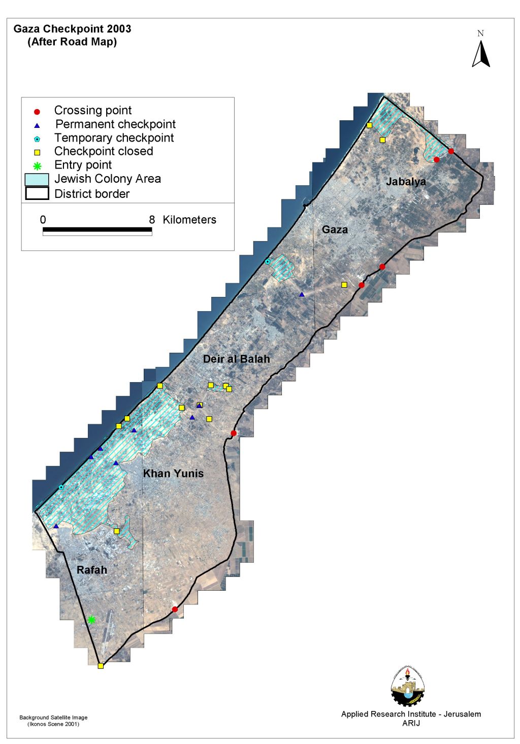
Map 13: Israeli Military checkpoints in the Gaza Strip
In cooperation with ARIJ partner PCHR Gaza, August 2003
A- Table shows the Palestinian population affected by Israeli checkpoints in Gaza Strip
|
District |
Population |
Number of Israeli Barriers |
||
|
Permanent |
Temporary |
Road block |
||
|
North Gaza |
179690 |
– |
– |
2 |
|
Gaza |
359941 |
1 |
1 |
1 |
|
Deir el-Balah |
144890 |
1 |
– |
5 |
|
Khan Yunis |
196662 |
5 |
– |
4 |
|
Rafah |
120386 |
1 |
1 |
2 |
Source: PCHR field survey, August 2003.
5. House Demolition
The case of Al walaja Village in Bethlehem District
On Wednesday morning, August 13, 2003, while the cool breeze of the mountains is still embracing the Palestinian village of Al-walaja East of Bethlehem district, a large number of Israeli troops accompanied by armored ironclad vehicles and bulldozers with a number of rackety police dogs broke up the usual calmness of the small village. Five demolished houses were demolished and 7 Palestinian families became homeless as a result of this obtrusion.
The Israeli bulldozers started closing the secondary roads of the village with earthred blocks and a sudden curfew was imposed over 1234 Palestinian inhabitants. The massed Israeli Occupation Forces-IOF moved into the village and specifically to the demarcated five houses forcing their residents to go out and leave everything behind.
House demolition figures in the West Bank 2003
|
Month |
Houses Demolishedin the West Bank during the period of June-August 2003 |
||
|
June |
July |
August |
|
|
Total |
89 |
11 |
45 |
Some of the demolished houses were still under a legal dispute in the Israeli court of Jerusalem for many years. In some cases, the Israeli court foiled the people by asking them to pay a fee reaches 50000 NIS (10638 EURO). A final deal between the householders and the Israeli court came out in order not to issue demolition orders through splitting the payment of the fee to be paid over several months. This deal was still ongoing when the Israeli bulldozers demolished the houses.See Figure 12

6. Growth of Israeli settlements
According to Israeli data, there are 149 Israeli settlements in the West Bank and Gaza, but by the end of 2002, satellite images show that there are 310 Jewish built-up areas in the West Bank, including East Jerusalem, and 26 in the Gaza Strip (figures exclude Israeli military sites). Currently more than 435,000 Israeli settlers live illegally in the West Bank and the Gaza Strip, 7,000 of them reside in Gaza and 200,000 in East Jerusalem. Between 2000 and 2002, satellite images showed 24 new Israeli settlements and 113 new outposts. Those settlements and outposts are distributed all over the West Bank, but primarily concentrated around Jerusalem., Latroun area, the Jordan Valley and Gush Etzion. Building settlements and attempting to change the demography in any occupied area is a direct violation of international law, specifically the Fourth Geneva Convention, Article 49, item 6, which states: 'The occupying power shall not deport or transfer part of its own civilian population into the territory it occupies.'
|
Year |
Settlement Area (sq. km) |
Percent of the West Bank |
|
1990 |
77.4 |
1.4% |
|
1996 |
103.9 |
1.8% |
|
2000 |
149.6 |
2.6% |
|
2001 |
154.7 |
2.7% |
|
2003 (January) |
167.25 |
2.96% |
Analysis of land use classification in the settlements of the Gaza strip reveals a pattern of settlement expansion. These land use classifications include new outposts as well as residential, agricultural, industrial and security areas (table2). The growth of Settlement Areas in the West Bank
| Percent of the West Bank |
Settlement Area (sq. KM) |
Year |
| 1.4% | 77.4 | 1990 |
| 1.8% | 103.9 | 1996 |
| 2.6% | 149.6 | 2000 |
| 2.7% | 154.7 |
2001 |
| 2.96% |
2003 |
(January) 2003
|
Source: ARIJ, GIS database 2002
The total area controlled by Israel in the Gaza Strip is 165.04 km², which is 45.7% of Gaza's total area. The land under Israeli control includes Israeli settlement areas, security zones, military installations, buffer zones and yellow areas.
In the Gaza Strip there are 6429 Israeli settlers who occupy 165.04 square kilometers, in contrast 1,001,569 Palestinians in Gaza occupy the remaining 197 km�². The Palestinian population density of 4471 persons/km2 is therefore 100 times greater than that of the settlers' population density, which is 43-persons/ km2. Since the outbreak of the second Intifada on September 2001, the Israeli army has launched massive 'Shaving of land' in the Gaza Strip. Almost, 3.5 km2 of agricultural lands had been bulldozed, and almost 750,000 trees have been uprooted until December 2002.
Areas controlled by Israel in the Gaza Strip
|
Jewish settlement area |
53.7 Km2 |
|
Israeli settlement |
26.66 Km2 |
|
Israeli security zone |
58.03 Km2 |
|
Israeli Military Installation Areas |
15.8 Km2 |
|
Yellow Areas |
8.43 Km2 |
|
Buffer Zones (Shaved) |
2.42 Km2 |
Source: ARIJ, GIS database, 2003
7. Settlers population growth
Construction of housing units has increased in both existing and new Israeli settlements in the Occupied Palestinian Territories (OPT). In addition, many Israeli citizens living inside Israel are trying to use settlement addresses as their permanent addresses in order to benefit from the financial incentives and grants given to settlers such as the 7% tax exemption and a grant of NIS 80, 000 for purchasing a new housing unit.See Figure 13
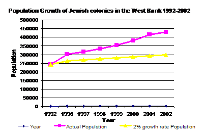
The myth of natural growth in Israeli settlements in the Palestinian Territories
The number of Israeli settlers in the West Bank at present is around 435,000. In Israel, the yearly natural population growth rate is calculated at around 2%. If the same population growth rate is applied to the Jewish population living in Israeli settlements in the OPT during the last 10 years, the number by the year 2002 should have been around 300,000 settlers, which indicates that the real increase in the number of settlers (435,000) is incompatible with the natural growth rate in Israel. The reason behind this enormous increase in the number of settlers refers to the Israeli policies of colonization and the many financial incentives given to the settlers and settlements.
The percentage of growth on the Israeli settlers of the West Bank during the period of July2002-July 2003 was 6 % (The Israeli Ministry of Interior, report on settler's population growth August 22, 2003). The highest percentage of growth was in Neghaot with 47, 8% and Hemdat with 39%. In addition, the report reveals that 67 settlements in the Palestinian territories had a higher growth rate than the Palestinian one during the same period. The high growth on settlers' population during the last year was due to the increase in immigrants' influx into the following settlements:
|
Settlement name |
Settlement population * |
Number of settlers added ** |
|
Arial |
16702 |
400 |
|
Betar Illit |
16519 |
3400 |
|
Modin Illit |
17489 |
2391 |
|
Maale Adummim |
26478 |
900 |
|
Efrat |
6606 |
400 |
* ARIJ database 2003.
** Al Quds newspaper, report on settlers' population, Israeli Ministry of Interior , August 23, 2003.
The following table gives number of some of Israeli settlements' population growth during the period of July 2002- July 2003:
|
Settlement Name |
Population (2001) * |
Rate of population growth ** |
|
Negohot |
140 |
47.8 % |
|
Hemdat |
140 |
39.9 % |
|
Minora |
529 |
28.6 % |
|
Giva Benyamin |
871 |
19.8 % |
|
Kfar Darom |
242 |
17.8 % |
|
Telem |
125 |
17.2 % |
|
Kiryat Netafim |
367 |
15.8 % |
|
Yizhar |
438 |
15.4 % |
|
Susiya |
528 |
12.9 % |
|
Talmon |
1354 |
11.7 % |
|
Revava |
542 |
11.2 % |
|
Mevo Horon |
459 |
11 % |
|
Otneil |
583 |
10.5 % |
|
Peduel |
870 |
9 % |
|
Shavei shomron |
592 |
8.9 % |
|
Yakir |
852 |
8.5 % |
|
Avnei Hefetz |
1181 |
8 % |
|
Maon |
353 |
7.8 % |
|
Karmei Zur |
480 |
6.7 % |
|
Elon Moreh |
1030 |
4.1 % |
|
Gilgal |
124 |
-7.4 % |
|
Immanual |
3270 |
-9 % |
|
Maale Amos |
400 |
-9 % |
|
Adora |
404 |
-12 % |
|
Yafit |
114 |
-13.8 % |
* ARIJ Database 2003.
** Al Quds newspaper, report on settlers' population, Israeli Ministry of Interior , August 23, 2003.
Following is a summary of the financial incentives and the financial allocations given for settlers and settlements.
8. Financial allocations given for Settlers and settlements in 2001
-
Incentives given to Israeli settlers NIS 200 million,
-
The Israeli settlements Unit: NIS114 million,
-
Israeli Local Authority budget: West Bank settlers received NIS 618 million,
-
Housing budget: The government allocated NIS 374 million in loans and grants to help Israelis purchase housing units inside the settlements,
-
Development and infrastructure budget: The Israeli Ministry of Housing allocated NIS186 million to the settlements,
-
Transportation: The Ministry of Transportation allocated NIS 396 million for the development of roads and infrastructure in the Israeli settlements,
-
Development of industrial zones: The Ministry of trade and Industry invested NIS 28 million for the development of industrial areas in the settlements,
-
Development of water resources: under the framework of a special plan the Israeli government transferred NIS 41 million to the Israeli settlements in the OPT.
Financing Israeli colonization in the Palestinian Territories in 2003
-
The Israeli government is devoting 1.9 billion dollars for the settlements in 2003,
-
The Keren Keyemet is providing 172.4 million shekels for the seizure of lands,
-
The Ministry of Transportation will use 253.5 million shekels from Israeli taxes to pave roads,
-
The Ministry of Defense will construct new bypass roads with a cost of 228 million shekels,
-
The Ministry of Commerce & Industry will provide between 22.3 and 51.9 million shekels for this sector in the settlements,
-
The Ministry of Housing is providing the settlements with 350 million shekels. The ministry is paying 20.6 million shekels for the protection of those settlers who are living in the old neighborhoods of Jerusalem. In addition, the ministry is offering 76.8 thousands Shekels as loans for each person who wants to buy a new apartment of which 16.8 thousand shekels are grants,
-
The Ministry of Agriculture is paying 137.8 million shekels for settlements,
-
The Ministry of Religious Affairs is giving 50 million shekels where 30 % of its budget is allocated for the building of Synagogues in these settlements,
-
The Ministry of Education is offering free education for settlers at the age of 4 years and provide incentives for teachers working in the settlements' schools, such as free studies at the university to upgrade their diplomas and levels of higher education at a cost of 30 million Shekels,
-
The Ministry of Infrastructure is providing 9.7 Million Shekels for water projects,
-
The Ministry of Interior is offering 480 million Shekels for the small settlements and localities, with the privilege of recuperating half a million shekels of taxes each year.
How can Israel afford such a financial demand?
-
Israel has asked the USA for 12 billion US $ as a loan guarantee, of which 4 billion US $ to become a grant. Following the onset of the war in Iraq the USA decided to grant Israel 9 billion US$ (Israeli newspaper, Haaretz, March 21, 2003).
-
It is worth mentioning here that the USA has granted Israel in 1991 another 10 billion US $ as a loan guarantee to convince the Shamir government to participate in the Madrid conference for peace in the Middle East.
This is in addition to many other financial resources that the settlements receive from inside and outside Israel.
[1] ARIJ Database 2003.
[2] Yellow areas are those areas that remain and Israeli military control in the Gaza Strip
Prepared by:
The Applied Research Institute – Jerusalem

&
Land Research Center-Jerusalem