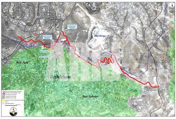
The southern part of the Segregation Wall
The Segregation Wall which is under construction by the Israeli Occupation Forces to surround Jerusalem (the Israeli so-called Jerusalem Envelope) along the northern and southern borders of Jerusalem has a length of 15 kilometers. It is segregating more than 15 thousand dunums of Palestinian agricultural lands planted mostly with olive trees and belong to Palestinian citizens living in Bethlehem area. Israeli's Unilateral segregation plans and walls ensure that Israel will completely seal off the Occupied East Jerusalem from the rest of the Occupied West Bank.
Creating facts on the ground or unilateralism drastically changes the parameters of a permanent solution to the Israeli-Palestinian conflict. Israel's expansion of Jerusalem's illegal boundaries is one example of such de facto policies that aim to augment the course of the negotiations over Jerusalem. Prime Minister Ariel Sharon's old-new plan to separate the city of Jerusalem from its Palestinian neighborhoods is a plan in progress.
Israel's policy of creating facts on the ground has increased since the invasion of Bethlehem district on April 1st,2002. A number of Israeli confiscation orders were issued and handed out to Bethlehem, Beit Jala and Beit Sahour municipalities. It is significant to note that this buffer zone is built solely for political reasons, ignoring the implications of such actions on Palestinian demography and geographical contiguity. In addition, the confiscation of land for Israeli military purposes will have negative consequences on the Palestinian communities and their economy. Bulldozing the land has resulted in uprooting hundreds of olive and apricot trees, as well as the diminution of Palestinian agricultural land. Many Palestinians depend on the products of olive and apricot trees. Depriving these families of this source of income will have a negative effect on their economic situation. See Map 1

Source: ARIJ, GIS database, 2003
The annexation of Bethlehem's Rachel Tomb to Israel
Rachel's tomb, located at the northern part of Bethlehem, is considered a pilgrimage place for Christians, Muslims and Jews. Rachel, the wife of Jacob, died in childbirth on the way to Hebron and was buried on the road to Bethlehem. The Tomb was neglected for many years until the Crusaders rebuilt it. The building which now houses the tomb was erected by the Turks in 1620 during the Ottoman period. Muslims considered the place sacred for its relation to Abraham and thus kept its keys. Rachel's Tomb is one of Bethlehem's historical sites and a part of the city's heritage. In the past two years, the Israeli occupation forces prevented Christians and Muslims from visiting the Tomb, thereby denying the Palestinians right of worship and limiting the shrine to Jewish groups in a primary step to annex the Tomb to Jerusalem.
According to Oslo II Agreement signed in 1995, the location of Rachel's Tomb falls in area C of Bethlehem district, i.e. under temporary Israeli security and civil control. The Palestinians retain the right to use the main road. Area C was supposed to be transferred to the Palestinian National Authority (PNA) within 18 months of the inauguration of the Palestinian legislative council. The Oslo II Agreement, Annex 1, Article V, section 7 states: ''The present situation and existing practices in the Tomb shall be preserved''. See Map 2
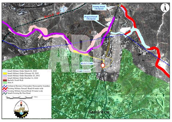
Map 2: The wall at the northern entrance of Bethlehem near Rachel's Tombas given in February 2003
Source: ARIJ, GIS database, 2003
On September 11, 2002, the Israeli security cabinet approved a plan to keep Rachel's Tomb under Israeli control by including the Tomb behind the Segregation Wall. See Map 2 above.
Rachel's Tomb has always been a part of Bethlehem, and a pilgrimage place for people of the three monotheistic religions. Today the Tomb is becoming a military camp and is only opened for Jews. The Israeli government's plans to annex the Tomb to Jerusalem will cost Palestinian citizens of Bethlehem – Chrisians and Moslems – their land, their homes and their heritage that they have conserved throughout history. Such Israeli policies will also damage the tourist industry in Bethlehem, as well as the Palestinian economy in general.
On Februrary 9, 2003 Mosheh Kaplenski, Chief Commander of the Israeli Occupation Forces in Judea & Samaria, issued a military order number (03/14/T Judea & Samaria 2003)to seize land in the North of Bethlehem to construct the Wall that will enclose and annex Rachel's tomb vicinity to Jerusalem. The map that the Israeli Occupation Forces (IOF) put at the residents' disposal shows that only 18 dunums will be seized and confiscated, but Israel will actually segregate around 3000 dunums of land behind the Wall. See Map 2.
Kaplenski classified in the order the parcels of land that are to be seized, with no other explanation than ''military reasons''. He also declared that the Israeli Occupation Forces (IOF) have an ''absolute control over it''. The wall will physically separate the city of Jerusalem with its two parts, east and west, from the West Bank.
On the 16th of February 2003, the IOF handed the residents military orders which showed the plan to strangulate the city of Bethlehem by confiscating its northern entrance and annexing it to Israel. Forty residential buildings inhabited by 500 people, a small industrial complex, a gas station and commercial shops will be isolated in this zone (any person will need a permit to visit them) and therefore they will be indirectly forced to leave.
The municipality of Bethlehem city revised the military order issued in February 2003 at the Israeli Supreme Court. The municipality also tried to explain the issue to different international organizations by showing the disadvantages of erecting such a Wall at the main entrance of the city. The answer was given 6 months later by providing a new map for the area. The new map shows changes on the ground but the wall itself will be erected. A number of 60 people will be enclosed inside this wall and later segregated them from Bethlehem city which will in turn limit the movement in and out of the military zone. See map of The segregation Wall north of Bethlehem.

Source: ARIJ, GIS database, 2003
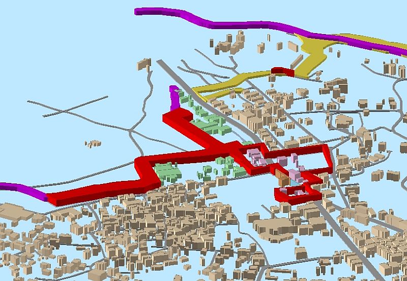
See a 3-D representation of the Wall (Map 3)
Related links:
1. The commencement of circulating the orthodox Housing Project in Beit Sahour
2. Ghettos are still created in Bethlehem District
3. Al-Khas and Al-Nu'man villages between the jaws of occupation
Prepared by:
The Applied Research Institute – Jerusalem