In cooperation with 'PCHRGAZA', http://www.pchrgaza.org/
1. Historical overview
2. Geopolitical background
3. Colonization policy and facts
a. Background on Israeli Colonization
b. Land fragmentation and Restriction of Movement
1. Checkpoints
2. Security fence
c. Land cover analysis
d. Analysis of settlements expansion
4. Comparative Political Land Use in Gaza Strip
5. House demolition
a. Gaza as case study
b. The segregation Wall in Gaza Strip.
6. References
Historical overview
The terms of the United Nations (UN) Partition plan in 1947 provided for the partition of Palestine into two states – Jewish and an Arab. The plan included the Gaza as part the Arab state. In 1948, during the war between the Jews and Arabs, the Egyptian forces retained the Gaza city and its surrounding area, which came to be called the Gaza Strip. This territory became under the control of Egypt by terms of the Arab Israeli armistice agreement in 1949. as a result of the 1948 war, some 200,000 Palestinian refugees started inflating into the Gaza Strip from parts of Palestine which became under Jewish control, therefore doubling its population. This influx has created many economic problems in the area, although the city of Gaza has bazaars, markets and some light industry, in addition to the fact that the Gaza Strip is an established citrus producing area, the economy cannot support the large population, which has been aided by the United Nations Relief and Works Agency for Palestinian Refugees in the Near East.
During the spring of the year 1956 several military clashes between Egypt and Israel took place in the Gaza Strip. Soon after in October, shortly before the invasion of the Suez Canal Zone of Egypt by the French and British forces, Israeli troops seized Gaza Strip and advanced into the Sinai Peninsula which in turn resulted in marching a UN emergency force replaced the Israeli troops, and Egypt regained control of the civil administration of the strip.
On June 10, 1967: The Israeli forces occupied the Gaza Strip and the West Bank (known later as the Occupied Palestinian Territories) as well as the Jolan heights after the Six-Days War that took place between Egypt, Jordan, and Syria at one side and Israel at the other side.
In the year 1987, the area eye witnessed the out break of Al-Intifada, which started by Palestinians demonstrations demanding self rule, independence, freedom and human rights.
On the 13th of September 1993, the Israeli Prime Minister Yitzhak Rabin and the Palestinian Chairman of the Palestine Liberation Organization Yaser Arafat, signed a peace accord in Washington calling for withdrawal of the Israeli military from the Gaza Strip and the other Palestinian occupied territories and outlining a 5-years interim period of governmental arrangements, envisioned by both sides as immediate Palestinian self-rule in Gaza and Jericho, early empowerment (Self Government) for the Palestinians in West Bank, and the election of a Palestinian Legislative Council.
Soon after the signing of the DOP in September 1993, negotiations started between the PLO and Israel to implement the 5-years interim agreement, which was agreed to be accomplished in stages, mainly three:
-
The Gaza-Jericho Agreement which was signed in Cairo on May 4, 1994, which stated the Israeli withdrawal from Gaza and Jericho, and the transfer of authority from the Israeli Civil Administration to the Palestinian Authority
-
Agreement on Preliminary Transfer of Powers and Responsibilities to the Palestinian Authority which was signed by the PLO and Israel on August 29, 1994.
-
The 'Oslo II' agreement, signed in Washington D.C. in September 28,1995, which sets out the interim stage for the Palestinian Autonomy in the West Bank and Gaza, pending 'final status negotiations' which were scheduled to begin in May 1996 and finish by May 1999. The Interim Agreement states that the first phase of the Israeli occupation forces redeployment will be completed prior to the eve of the Palestinian elections, i.e., 22 days before the day of the elections. The further redeployments were to be completed within 18 months from the date of the inauguration of the Council.
During this time, the powers and responsibilities relating to territory will be transferred gradually to Palestinian jurisdiction to cover West Bank and Gaza Strip territory, except for the issues that will be negotiated in the permanent status negotiations (i.e. Jerusalem and the Settlements). This meant that 95 % of the West Bank and Gaza should have become under Palestinian control 18 months after the inauguration of the Council.
In January 1996, the first Palestinian Democratic Elections were held and Mr. Yasser Arafat was elected as a President of Palestine, though implementing the Oslo I agreement which allows the Palestinians to elect their own President and contribute in the formation of Legislative Council which will later be in power of agreed spheres such as education and culture, health, social welfare, tourism, direct taxes and added taxes on local production making no reference to Jerusalem city nor to the settlements and Israeli military installations.
Gaza, (Arabic Ghazze), city and port, about 32 km north of the Egyptian border, has given its name to Gaza Strip, a narrow strip of land along the western shores of the Mediterranean which now covers 362.7 km square and extends northeast from the Sinai Peninsula.
II. Geopolitical Background
Since the 1967 occupation, Israel has either confiscated or declared as closed areas over 25% of the Gaza Strip, thereby placing those areas out of Palestinian reach. Palestinians are allowed to use less than 15% of their water resources. Israel has pursued a policy of colonizing Palestine through settlements in an attempt to change its demographic character. Presently, there are 26 Israeli settlements in the Gaza Strip housing an estimated 6429 Israeli settlers.
The Madrid Conference faltered mainly around the issue of settlements freeze, and the DOP called for an interim period of 5 years during which the Israeli military would gradually withdraw its army from the Palestinian territory and transfer authorities to the repatriated PLO, as representatives of the Palestinian people. The Israeli government would initiate negotiations over the unresolved (final status) issues, which include Jerusalem, refugees, settlements, borders and water, all corner stones of the Israeli-Palestinian conflict. The final status negotiations were scheduled to begin in May 1996 and finish by May 1999. It was also agreed upon that neither party should initiate any action during the interim period that might jeopardize the outcome of final status negotiations.
As mentioned earlier, a series of subsequent agreements, popularly known as the Oslo Accords, were signed in order to implement the DOP. In Oslo I of May 4, 1994 (Map 8), the Israeli government agreed to withdraw from Jericho and most of Gaza, where the newly formed Palestinian National Authority (PNA) would assume control. The Gaza Strip was delineated by an unbroken line and partitioned into:
1. Those areas which fall under a complete Palestinian control and marked as area A in the West Bank.
2. Those areas (mostly Yellow areas) where authority in security matters is to be shared as in area B in the West Bank, and
3. Those areas where security matters fall entirely within the jurisdiction of Israeli forces as in area C in the West Bank. See Map 1

Map 1: A Map demarcating the three jurisdiction areas including Yellow areas
In accordance with the 'Oslo II' agreement of September 28, 1995, Israel withdrew its forces from more areas of the West Bank and the land was further divided into Areas A, B, and C, which are designated as varying levels of control as mentioned above.
Colonization policy and facts
Background on Israeli Colonization
Israeli land policy in the Palestinian Territories focuses on land expropriation for the expansion of Israeli settlements and thus eclipsing the prospect for a viable Palestinian state with sovereignty over the remaining 22% of historical Palestine. Circumventing the legal system, undertaking military action and implementing de facto policies under the slogans of peace have achieved Israeli occupation and colonization.
The scope and type of land affected by Israeli colonization on the Palestinian territory is determined by the unique geopolitical ambitions of Israel to create an ethnic Jewish state in as much of historical Palestine as possible. Two primary goals guide the expropriation of Palestinian land for the colonization project: expansion and separation from the Palestinian population.
Though Likud emphasizes the former and Labor the latter. Both of Israel's main political parties juggle these two goals as they extend and reinforce Israeli control over the Palestinian territory. Land is therefore chosen for expropriation on hilltops overlooking and surrounding Palestinian built-up areas, areas that block the merging of Palestinian built-up areas while facilitating the merging of settlements, areas that may be easily annexed to Israeli proper in the future, or that secure economic resources, militarily advantage or negotiating leverage. In total, Israel controls 60% of the West Bank and 22% of Gaza Strip. See Map 2

Map 2: Total Israeli controlled areas in Gaza Strip and in the West Bank
The growth of settlements is mainly geared to the formation of blocks; i.e. they grow outwards and towards each other. Successive Israeli governments have encouraged the development of specific blocks more than others. The result of such a growth is the grouping of Palestinian towns and villages into many separate cantons. Indeed, the Israeli intention is to make the contiguity of any Palestinian state in the future practically unattainable.
Israel has succeeded in confiscating Palestinian land by framing their activities within a legal framework; but these justifications changed over time and never created a deterrent to the policy of colonization itself. The primary Military Order used to legitimate the confiscation of Palestinian land is Military Order 58 of 1967, known as the Absentee Property Law. The Military Order transfers lands and properties of absentee Palestinians to the Civil Administration. An absentee is defined as any Palestinian who left the West Bank before or after June 7, 1967. As a result, 340 km�² were confiscated at favor of Military order 58 and defined as abandoned property.
In 1969, the Civil Administration issued Military Order 321, which gave the military the power to confiscate land for public services, where 'public' in Israel's terminology ice' actually means 'for Jews.' Thus 'Public' works in the Palestinian territory are inevitably those that benefit the Jewish settlements and bypass roads. These Military Orders and others have for the past 35 years facilitated the expropriation of Palestinian land for Israel's colonial project.
The settlements are not subject to any of the legal difficulties that Palestinian communities face. They are administered through a completely different process and the settlers live under Israeli civil law. The plans for the settlements are approved smoothly and the settlers are free to use the land as they please. Even if new settlements are built or land confiscated outside the legal process by the settlers, they are rarely challenged and perhaps are encouraged by Israel authorities. The implications of this discrimination on Palestinian landholding are clear and severe.
Table 1-a: Increase in Settlements' areas in Jabalya district
|
District |
No. |
Settlement name |
Total area in dunums 2001 |
Total area in dunums 2003 |
Increase during the period of 2001& 2003 |
Percent |
|
Jabalya |
1 |
Dugit + Dugit Site |
591.34 |
674.6 |
83.26 |
14% |
|
Jabalya |
2 |
|
0 |
0 |
0 |
0.00% |
|
Jabalya |
3 |
Elei Sinai |
447.13 |
549 |
101.87 |
22.7% |
|
Jabalya |
4 |
Erez |
565.99 |
565.99 |
0 |
0.00% |
|
Jabalya |
5 |
Nisanit + Nisanit (New Site) |
1132.1 |
1266.12 |
134.02 |
11.8% |
|
Jabalya |
6 |
|
|
|
|
|
|
Jabalya |
7 |
|
|
|
|
|
|
Total |
|
|
2736.56 |
3055.71 |
319.15 |
|
|
Total in (Percent) |
|
|
11.6% |
|||
Settlements such as Dugit, Elei Sinai, Erez, Nisanit located in Jabalya district witnessed a considerable increase of their area since 2001. The total area of the settlements in 2001 was 2736.56 dunums whereas this area increased as the Israeli government continued their violations to expand the settlements area to reach 3055.71 dunums in 2003.
Table 1-b: Increase in Settlements' areas in Gaza city
|
District |
No. |
Settlement name |
Total area (dunums) |
Total area (dunums) |
Increase |
Percent |
|
Gaza |
8 |
Netzarim + Netzarim B |
1546.22 |
1566.25 |
20.03 |
1.3 % |
|
Gaza |
9 |
|
|
|
A total increase of 20.03 dunums was registered in Netzarim settlement in Gaza city since 2001. As shown in the table, the settlement's area in 2001 was 1546.22 dunums whereas this area increased as a cause of the Israeli expansion through shaving of lands to reach 1566.25 dunums.
Table 1-c: Increase in Settlements' areas in Khan Yunis city
|
District |
No. |
Settlement name |
Total area in dunums-2001 |
Total area in dunums-2003 |
Increase |
Percent |
|
Khan Yunis |
10 |
Bedolah |
3043.03 |
3049.97 |
6.94 |
0.2% |
|
Khan Yunis |
11 |
Gadid |
3158.54 |
3158.54 |
0.00 |
0.00% |
|
Khan Yunis |
12 |
Gan Or |
982.21 |
993.77 |
11.56 |
1.18% |
|
Khan Yunis |
13 |
Ganei Tal |
1920.68 |
1933.37 |
12.69 |
0.66% |
|
Khan Yunis |
14 |
Gaza Beaches |
186.93 |
188.49 |
1.56 |
0.83% |
|
Khan Yunis |
15 |
Gaza Beaches Site |
108.16 |
111.46 |
3.30 |
3.05% |
|
Khan Yunis |
16 |
Katif |
1313.67 |
1313.67 |
0.00 |
0.00% |
|
Khan Yunis |
17 |
Kfar Yam |
90.66 |
96.09 |
5.43 |
5.9% |
|
Khan Yunis |
18 |
Morag |
1101.54 |
1201.61 |
100.07 |
9% |
|
Khan Yunis |
19 |
Netzar Hazani |
1965.93 |
2441.80 |
475.87 |
24.2% |
|
Khan Yunis |
20 |
Neve Dekalim |
1910.28 |
1939.83 |
29.55 |
1.55% |
|
Khan Yunis |
21 |
North west Netzar Hazani |
228.78 |
302.33 |
73.55 |
32.1% |
|
Total |
|
16010.41 |
16730.93 |
720.52 |
4.5% |
|
As for Khan Younus city, there has been an enormous increase of the settlements' areas since 2001, specifically in Morag, Netzar Hazani and North West Hetzar Hazani settlements. The table above shows that a total increase of 720.52 dunums were registered till 2003 which is a clear evidence of the continuous Israeli policy to shave lands at favor of settlement expansion under the pretext of security reasons or for military purposes.
Table 1-d: Increase in Settlements' areas in Rafah city
|
District |
No. |
Settlement name |
Total area (dunums) in 2001 |
Total area (dunums) in 2003 |
Increase |
Percent |
|
|
Rafah |
22 |
Atzmona (Bnei Atzmon) |
2868.01 |
2868.01 |
0.00 |
0.00% |
|
|
Rafah |
23 |
Pe'at Sade |
1471.16 |
1476.59 |
5.43 |
0.37 % |
|
|
Rafah |
24 |
Pe'at Sade (New Site) |
442.72 |
450.21 |
7.49 |
1.7% |
|
|
Rafah |
25 |
Rafih Yam |
1121.62 |
1138.13 |
16.51 |
1.5% |
|
|
Total |
|
|
5903.51 |
5932.94 |
29.43 |
0.5 % |
|
In Rafah district as shown in the table above, a total increase of 29.43 dunums was registered since 2001, specifically in Rafih Yam settlement where most of the expansion occurred. The area witnessed and is still under the threat of more land shaving or land confiscation for military purposes which in turn affects the future of the Palestinian communities in Gaza Strip since Gaza is very populated area.
Table 1-e: Increase in Settlements' areas in Deir Al Balah.
|
District |
No. |
Settlement name |
Total area in dunums 2001 |
Total area in dunums 2003 |
Increase |
Percent |
|
Deir al Balah |
26 |
Kfar Darom |
460.63 |
460.63 |
0 |
0.00% |
|
Total |
|
0.00% |
||||
|
Grand Total |
|
|
26657.33 |
27746.46 |
1089.13 |
4.1% |
As it could be analyzed from this table, the overall increase of settlements areas in Gaza Strip is 1089.13 which violate international laws. The Israeli Colonization activities continue to shave and confiscate more lands for phony justification at the same time affecting the future of the city.
Land fragmentation and restrictions of movement
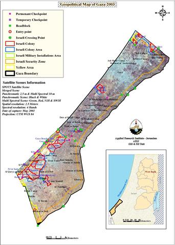
The restrictions of movement on Palestinians within the various areas of Gaza strip has been arbitrated by the erection of several Israeli checkpoints within the main roads in the Gaza Strip in addition to internal checkpoints and road blocks which were installed in certain areas close to the Israeli settlements and access roads. Al- Mawasi areas, classified by Oslo agreement as yellow areas are suffering mostly from harsh restriction on movement and curfews are imposed by the Israeli Occupation forces-IOF on Palestinian civilians.
According to ARIJ and PCHR field surveys, August 2003, a total number of 24 checkpoints and road blocks are dividing the Gaza Strip into three separate geographical units. See Map 3

Map 3: Checkpoints and Roadblocks in Gaza Strip
Because of its coastal location and closeness to Gush Katif Jewish block, the Israeli Occupation Forces-IOF restricted the entry and exit on Al-Mawasi residents', thus dividing the area into three ways: through the Tufakh crossing in Khan Younis, the Rafah crossing in Rafah, and via the costal Road.
Since the outbreak of Al-Aqsa Intifada in September 28, 2003, the IOF has placed additional restrictions on Palestinian movement in al-Mawasi. Entry was restricted only to residents who only have magnetic cards identified by a number provided by the Israeli Authority; moreover, only one checkpoint is opened for those card holders and for a specific period of time during the day. See Map 4

Map 4: A detailed Map of Al Mawasi area, northwest Gaza Strip
In addition to the Israeli checkpoints and road blocks, a long fence of 1.26 km length surrounds the Gaza Strip with a security buffer zone of about two kilometers width had been sit , transforming the whole area into a collective mega prison. A total area of 58.03 km area is declared as security zone border along side the Gaza Strip. In addition to the massive devastation of agricultural lands and the uprooting of trees were committed by the IOF at favor of 'security reasons'.
Table 2: The Palestinian population affected by Israeli checkpoints in Gaza Strip
|
District |
Population |
Number of Israeli Barriers |
||
|
Permanent |
Temporary |
Road block |
||
|
North Gaza |
179690 |
– |
– |
2 |
|
Gaza |
359941 |
1 |
1 |
1 |
|
Deir el-Balah |
144890 |
1 |
– |
5 |
|
Khan Yunis |
196662 |
5 |
– |
4 |
|
Rafah |
120386 |
1 |
1 |
2 |
Source: PCHR field survey, August 2003.

Map 5:-Map of comparison of land devastation in the northern part of the Gaza Strip
Land cover analysis
According to land use classifications of the settlements in the Gaza Strip, ARIJ GIS unit was able to detect patterns of settlement expansion in the Gaza Strip. These land use classifications include new outposts as well as residential, agricultural, industrial and security areas.
Table 3: Areas controlled by Israel in Gaza Strip
|
Jewish settlement area |
53.7 Km2 |
|
Israeli settlement |
26.66 Km2 |
|
Israeli security zone |
58.03 Km2 |
|
Israeli Military Installation Areas |
2.418 Km2 |
|
Yellow Areas |
15.8 Km2 |
|
Buffer Zones (Shaved) |
8.43 Km2 |
It is important to mention that the Jewish settlement area which counts 53.7 Km2 of the total Israeli controlled area is overlapped by the Israeli settlement area and the yellow areas.
Table 4: Land use classification and expansion in Israeli settlements in Gaza.
Total area controlled by Israel in Gaza Strip is 165.04 square kilometers which occupies 32.13 % of Gaza's total area. The area controlled consists of Jewish settlement area including settlement built up areas, security zones, military installations, buffer zones and yellow areas. Such areas often overlap; therefore, the total area controlled (165.04 km2) is not the sum of the areas detailed in table 3. Map 6 illustrates the overlap between Israeli areas in the Gaza Strip. See Map 1 for further details.
6429 Israeli settlers occupy 165.04 square kilometers (overlapped), whereas 1,001,569 Palestinians occupy the remaining 200 square kilometers only. The Palestinian population density of 4471 persons/km2 is therefore 100 times greater than that of Jewish population density, which reaches 43 persons/ km2.
Since the outbreak of Al-Aqsa Intifada, Israeli army launched massive operation of 'Shaving land ' in Gaza Strip (See Map 5). Elei Sinai, Dogit plus Dogit site, Nisanit plus Nisanit new site and Erez Settlements in Beit Hanoun are special cases in the northern parts of Gaza Strip as shown in Map 6. Map 6 depicts the borders of the four settlements which constituted an area of 2736.56 dunums in 2001 and the expansion that took place since then to link the three settlements together which constituted an area of 3055.71dunums, which shows a total expansion of 319.15 dunums.
The blue color in Map 6 indicates the borders of the four settlements in 2001. The red color indicates the expansion that occurred till 2003 and the yellow color clearly shows the shaving of land to expand the settlements's borders.

Map 6: Expansion of Israeli Settlements in Gaza Strip
IV. Comparative Land Use in the West Bank and Gaza Strip
Distribution of land for both Palestinians and Israelis is not a clear-cut issue because of the ongoing disputes over land between the two sides. There are different classifications to consider when determining the distribution of land. The total area claimed by Palestinians for their future state is the sum of both areas, the West Bank (including East Jerusalem) and Gaza Strip, which reach a total of 6212 square km.
On the ground, the Palestinian Authority after signing the peace accords, got control over a small percentage of the West Bank and Gaza Strip. In the West Bank, the Palestinians have total control of 1004.8 sq. km what is known as Area A which covers 18% of the the West Bank area only. Area B, which is 1200.4 square km, covers 21% of the West Bank, where Palestinians control civil issues only. This area also entails nature reserves. Area C comprises the remaining 3455.8 square km of the West Bank, is totally under the Israeli control in addition to East Jerusalem, which is still under Israeli control. Thus, the total area accessible for Palestinians in the West Bank is the sum of areas A and B, which reaches 2205.2 square km, i.e. 35% of the West Bank only.
The rest of the West Bank is seized for colonization purposes. Area C entails Jewish settlements, military bases, closed military areas and a sophisticated network of bypass roads that circumvent Palestinian built-up areas found in Area C. There is a total of 167.2 square km of Jewish built up areas in the West Bank, of which 39.4 square km is in East Jerusalem. However, the total accessible land for Jewish settlements in the West Bank reaches 3455.8 sq. km. In fact, the proposed security zone in the West Bank swallows 2565 sq. km of the West Bank, almost 45% of its total area. Also, it is important to note that the master plan for Jewish settlements in the West Bank includes an area of 497.5 sq km, which is 8.5% of the West Bank. This means that Palestinians will end up with less than a fair deal and far less than they rightfully claim. Also, the remaining area for Palestinians will not be a contiguous piece of land, rather it will be a fragmented area, where its built up areas are carved up by Jewish settlements and by pass roads; not to mention a matrix of checkpoints and roadblocks.
In Gaza Strip, Israel has access to 165.04 sq. km (overlapped) of a total area of 365 square km. This area includes Jewish settlement areas, yellow area and buffer zones. The Jewish settlement area is classified into residential, agricultural and industrial areas. The total built-up area of Jewish settlements in the Gaza Strip reaches 26.66 sq. km. The 1 million Palestinians living in the Gaza Strip have access to the remaining 200 square km, housing a built-up area of 50.3 sq. km only.
Table 4: Areas controlled by Israel in the Gaza Strip
|
Jewish settlement area |
53.7 Km2 |
|
Israeli settlement |
26.66 Km2 |
|
Israeli security zone |
58.03 Km2 |
|
Israeli Military Installation Areas |
2.418 Km2 |
|
Yellow Areas |
15.8 Km2 |
|
Buffer Zones (Shaved) |
8.43 Km2 |
Source: ARIJ, GIS database, 2003
All in all, there are approximately 684 Palestinian built-up areas in Palestine, of which 642 are located in the West Bank covering an area of 365.5 sq. km. In addition, there are 18 refugee camps scattered throughout the West Bank, hosting approximately 103,022 refugees. Almost 90% of the Palestinian built up areas in the West Bank are located within the mountainous range of the Central Highlands and the Western Slopes, whereas a limited number are located in the Jordan Valley. This is largely due to restrictions imposed by Israel on granting building permits. There are 42 Palestinian built-up areas in the Gaza Strip, which cover an area of 50.3 square km, along with 8 refugee camps hosting 250,604 refugees.
On the other hand, there are more than 250 Israeli settlements and sites in the West Bank occupying an area of 2.0% of West Bank land with a population of more than 405,000 settlers; of which 195,000 reside in East Jerusalem. These settlements are distributed all over the West Bank, primarily condensed in East Jerusalem and in the Jordan Valley. Building has been restricted to Palestinians in the Eastern Slopes and the Jordan Valley areas since 1967. Due to these constraints on building activities in these areas, many of the housing constructions in the West Bank were done on agricultural land.
In Gaza Strip, however, there are 26 settlements populated with an estimated number of 6500 Israeli settlers, occupying approximately 2.5% of the Gaza Strip land. Most of these settlements are found in the southwestern and northern part of the Gaza Strip adjacent to the Mediterranean coast.
The table below further details the distribution of land among Palestinians and Israelis in Israel, West Bank, Gaza Strip and East Jerusalem:
Table 5: Comparison of Land Use Indicators of Palestinians and Israelis:
Population density of a country could be defined as the number of human beings living in that specific country divided by the total area that this country spans. This assumes that inhabitants have full access over their country regardless of the condition and nature of land cover type, climate, and topology, whether a desert or an agricultural land, a seashore or mountain hills, this all counts in a country's area. In the case of Palestine, a modification of this definition is obviously needed! Though the boundaries of the West Bank are clearly defined and mapped, and its area is easily determined through GIS, still this area cannot be used as the total area in which Palestinians live in, since Palestinians do not inhabit this area in actuality, as was discussed above.
Considering the political restriction over Palestinian land use, two modes of calculation were followed to find the population densities for both Palestinians and Israelis. One was to divide the population over built-up areas and the second was to divide the population over accessible land. The average population density calculated on areas currently inhabited by Palestinians[1] in the West Bank reaches 5097 individual per km2. This figure is different in area A, where Palestinian major cities are, than it is in area B. In contrast, the population density in Israel does not exceed 261 individual per km2 (Statistical Abstract of Israel, 1997).
As shown in the table above, there is a significant gap between Palestinian and Israeli population densities, especially between Palestinians residing in the Gaza Strip and Jewish settlers settling in the Gaza Strip. When computing population density as the total population over built-up areas, the population density for Palestinians reaches 19880 individuals per sq. km, whereas it reaches only 266 individuals per sq. km for the Jewish settlers. The contrast is still high considering the second computation; the population density of Palestinians is almost 80 times higher than that of Jewish settlers in the Gaza Strip, where it reaches 4454 individuals per sq. km in contrast with 51 for Jewish settlers.
Thus, the distribution of land among Palestinians and Israelis is biased in favor of Israel and Jewish settlers. Overcrowded Palestinians live in scattered and separated areas with limited access to natural resources and constricted open space to absorb future natural growth of the Palestinian population. Besides the economic and environmental constraints that arise from such discrimination in land distribution, Palestinians continue to be subjugated under an Israeli military occupation with bleak prospects for a Palestinian state over the West Bank and Gaza Strip.
V. House Demolition
For purposes of accuracy and due to the crisis of accessibility, ARIJ cooperates with The Palestinian center for Human rights-PCHR centered in Gaza in order to conduct a field survey to verify the Palestinian houses and properties that have been demolished in Gaza. An overall number of 541 Palestinian homes were demolished in the five districts of the Gaza Strip since the beginning of 2003 till end of August 2003. Source: ARIJ & the Palestinian center for Human rights-PCHR Gaza.
The demolition of the Palestinian houses had made hundreds of families homeless and made a sever devastation to their properties since most of the Israeli attacks came out without any pre warning. In the same time, the random shelling of houses-due to it�¢??s approximately to the border lines where most of the Israeli military installation are located, has put the life of the residents of most Gaza�¢??s areas in danger. According to the Palestinian National Information Center (PNIC) of the State Information Service (SIS), since the outbreak of Al-Aqsa Intifada in September 2000, up to July 2003, 2.647 Palestinian lives have been claimed by the Israeli occupying forces (IOF) in the Palestinian territories. Palestinians killed were included 1,157 (%43.7) in Gaza Strip and 1,490 (%56.3) in the West Bank. As for the number of wounded, 36,448 Palestinians have been wounded by the IOF over the past 34 months, including 25,058 in the West Bank and 11,390 in the Gaza Strip.
[1] Palestinian built up areas covering area A, B, or C
Gaza as a Case study�¢?�¦
The Fourth Geneva Convention in 1949 'article 33, first Paragraph that lays: 'a prohibition on collective punishments of any kind inflicted on persons or entire groups in defiance of the most elementary principles of humanity, for acts these persons have not committed and all measures of intimidation or terrorism with regard to protected persons, whatever they may be. Thus, strike at guilty and innocent alike is opposed to all principles based on humanity and justice.
In contradiction to the previous mentioned paragraph, the Israeli occupation forces (IOF) are practicing a collective punishment policy on Palestinian civilians in the West Bank and Gaza Strip. Since the outbreak of the second Intifada in September 28, 2000, Gaza Strip has been facing a series of violations committed by the Israeli occupation forces (IOF) and resulting in a huge campaign of house demolitions and confiscation of land. Hundreds of families are now considered homeless due to the Israeli violation in the area and people are suffering from poor living conditions.
On Sunday, the 7th of September, the Israeli army backed by Bulldozers destroyed seven houses and partially damaged many others in Rafah refugee camp, the southern-most camp along the Egyptian border. Following this military operation, the Israeli occupation forces (IOF) escalated its violation on Thursday, the 11th of September 2003 against the Palestinian territories and demolished another 16 houses in Yebna refugee camp in the city of Rafah without pre-warning. The bulldozers also destroyed the camp's infrastructure resulting in power outage and the destruction of several water and phone lines. The number of families turned homeless was almost 35, a sum of 165 family members, mostly children. The houses are owned by the families of Abed Al-al, Abu Taha, Abu Jaser, Shaqfa, Al Taweel, Redwan And Al Arja families.
In a field survey conducted by ARIJ's partner 'PCHR' in Gaza Strip. During the first ten days of September 2003, the Israeli forces incurred into a number of Palestinian villages in Gaza Strip and razed 70 dunums of agricultural land all cultivated with Olive and fruitful trees. Most of the operations were carried out in Rafah, Deir Al Balah and Khan Younus; in addition to the destruction of many types of agricultural equipments. The tables below clarify the Israeli violations against the agricultural sector in Gaza Strip: For further information
-
Table 1: Israeli violations in the Gaza Strip on September 4th, 2003
-
Table 2: Israeli violations in the Gaza Strip on September 5th, 2003
-
Table 3: Israeli violations in the Gaza Strip on September 5th, 2003
-
Table 4: Israeli violations in the Gaza Strip on September 5th, 2003
-
Table 5: Israeli violations in the Gaza Strip on September 6th, 2003
-
Table 6: Israeli violations in the Gaza Strip on September 7th, 2003
-
Table 7: Israeli violations in the Gaza Strip on September 8th, 2003
-
Table 8: Shelling of Palestinian houses dated on September 11,2003
-
Table 9: Partial House demolition in Block L of Yibna refugee camp
dated on September 11,2003 -
Table 10: Partial House demolition in Block L of Yibna refugee camp
-
Table 11: Partial House demolition in Block L of Yibna refugee camp
dated on September 14, 2003 -
Table 12:Various violations dated on September 15, 2003
-
Table 13: Partial and Total house demolition dated on September 15,2003
Table 1: Israeli violations in the Gaza Strip on September 4th, 2003
|
No |
Location |
Type of violation |
People affected |
Area |
Losses |
|
1 |
Southeast Deir Al Balah |
Razing of agricultural land |
Hatem Mohammed Ahmad abu Samra |
28 dunum |
Olive, Citrus & Fruits trees |
|
|
|
Razing of concrete wall and spiked fence |
|
200m, |
|
|
2 |
Southeast Deir Al Balah |
Razing of agricultural land |
Khalil Suliaman Hasan Abu Samra |
2 dunums |
Olive & Palm trees |
|
|
|
Razing of spiked fence |
|
300 m length |
|
|
3 |
Southeast Deir Al Balah |
Razing of agricultural land |
Salamah Suliaman Hasan Abu Samra |
1.5 dunum |
Olive, Citrus & Fruits trees |
|
4 |
Southeast Deir Al Balah |
Razing of agricultural land |
Omar Suliaman Hasan Abu Samra |
1.5 dunum |
Olive, Citrus & Fruits trees |
|
5 |
Southeast Deir Al Balah |
Razing of agricultural land |
Hasan Suliaman Hasan Abu Samra |
4 dunums |
Olive, Citrus and Palm trees |
Source: PCHR field survey, September 2003.
Table 2:- Israeli violations in the Gaza Strip on September 5, 2003.
|
No. |
Location |
Type of violation |
People affected |
Area |
Losses |
|
1 |
Al Mughraqa area, south of Gaza strip |
Razing of agricultural land |
Hasan Ali Al Derawi |
1.5 dunum |
Olive and Figs trees |
|
|
|
Razing of spiked fence |
|
50m length |
|
|
2 |
Al Mughraqa area, south of Gaza strip |
Razing of agricultural land |
Suliaman Ali Al Derawi |
2.5 dunum |
Olive and citrus trees |
|
|
|
Razing of spiked fence |
|
200m length |
|
|
3 |
Al Mughraqa area, south of Gaza strip |
Razing of agricultural land |
Mahmmoud Sha'ban Al Helo |
5 dunums |
Olive and citrus trees |
|
|
|
Razing of spiked fence |
|
200m |
|
|
4 |
Al Mughraqa area, south of Gaza strip |
Razing of agricultural land |
Majed Abdullah Al Hasanat |
0.5 dunum |
citrus trees |
|
5 |
Al Mughraqa area, south of Gaza strip |
Razing of agricultural land |
Isaac Abdel Karim Hassan |
1 dunum |
corn |
|
6 |
Al Mughraqa area, south of Gaza strip |
Razing of agricultural land |
Ra'fat Sulaiman Shain |
0.5 dunum |
olive trees |
|
7 |
Al Mughraqa area, south of Gaza strip |
Razing of agricultural land |
Zuhair Al 'Alami |
1 dunum |
citrus trees |
|
8 |
Al Mughraqa area, south of Gaza strip |
Razing of agricultural land |
Abdel Fattah Ahmad Hamdan |
2.5 dunum |
Olive and Figs trees |
|
|
|
Razing of concrete Wall |
|
200 m length |
|
|
9 |
Al Mughraqa area, south of Gaza strip |
Razing of agricultural land |
Faraj Rashad Al Malhi. |
3 dunums |
Olive trees |
Source: PCHR field survey, September 2003.
Table 3: Israeli violations in the Gaza Strip on September 5th,2003
|
No. |
Location |
Type of violation |
People affected |
Area |
Losses |
|
1 |
Zuroub Square, southwest Rafah city |
Razing of agricultural land |
Nour Al Deen Breka |
3 dunums |
Olive trees and green beans |
|
2 |
Zuroub Square, southwest Rafah city |
Razing and destruction of agricultural equipments |
Farouq Mohammad Breka |
3.5 dunums |
3 Green houses+ water network+ pumping motor and water pool |
|
3 |
Zuroub Square, southwest Rafah city |
Razing of agricultural land |
Saleh Mohammad Breka |
3.5 dunums |
olive trees |
|
|
|
Razing and destruction of agricultural equipments |
|
|
Agricultural equipments room water network+ pumping motor and water pool |
|
4 |
Zuroub Square, southwest Rafah city |
Razing of agricultural land |
Salah Mohammad Breka |
3.5 dunums |
Olive trees, Green beans and Eggplants |
|
|
|
Razing and destruction of agricultural equipments |
|
|
Agricultural equipments room water network+ pumping motor and water pool |
|
5 |
Zuroub Square, southwest Rafah city |
Razing and destruction of agricultural equipments |
Ahmad Muhammad Breka |
3 dunums |
3 green houses + 40m depth well +water network+ pumping motor and water pool |
|
6 |
Zuroub Square, southwest Rafah city |
Razing and destruction of agricultural equipments |
Omar Muhammad Breka |
3 dunum |
3 green houses + 40m depth well +water network+ pumping motor and water pool |
|
7 |
Zuroub Square, southwest Rafah city |
Razing of agricultural land |
Hafez Tawfiq Breka |
2 dunums |
olive trees |
|
|
|
Razing and destruction of agricultural equipments |
|
|
water network+ pumping motor and water pool |
|
8 |
Zuroub Square, southwest Rafah city |
|
Yousof Muhammad Breka |
3500 m2 |
Water network |
|
9 |
Zuroub Square, southwest Rafah city |
|
Ahmad Muhammad Breka |
3500 m2 |
Water network |
|
10 |
Zuroub Square, southwest Rafah city |
Razing of Concrete Wall |
Ahmad Sulaiman Hijazi |
40 meters |
|
Source: PCHR field survey, September 2003.
Table 4: Israeli violations in the Gaza Strip on September 5th, 2003
|
No. |
Location |
Type of violation |
People affected |
Area |
Losses |
|
1 |
Um Al Selk, southwest Khan Younus City |
Razing of Agricultural land |
Issa Mustafa Al Lahham |
21 dunums |
Onion |
|
|
|
Razing of agricultural equipments |
|
|
3 green houses |
|
|
|
Razing of agricultural equipments |
|
100 m2 |
4 agricultural rooms |
|
|
|
Razing of agricultural equipments |
|
|
water network+ pumping motor and water pool |
|
2 |
Um Al Selk, southwest Khan Younus City |
Razing of agricultural land and destruction of equipments |
Sami, Ghazi and Suhail Hasan Shehdeh |
8 dunums |
8 green houses+ destruction of a water network |
|
3 |
Um Al Selk, southwest Khan Younus City |
Razing of agricultural lands |
Fadel Hijazi Odeh Hijazi |
2 dunums |
Cucumbers |
|
|
|
Razing of agricultural equipment |
|
|
Water network |
Source: PCHR field survey, September 2003
Table 5:- Israeli violations in the Gaza Strip on September 6th,2003
|
No. |
Location |
Type of violation |
People affected |
Area |
Losses |
|
1 |
Um Al Selk, southwest Khan Younus City |
Razing and destruction of agricultural equipments |
Khaled Odeh Hijazi |
2 dunums |
Green house cultivated with Cucumber + destruction of water network and a spiked fence |
|
2 |
Um Al Selk, southwest Khan Younus City |
Razing of agricultural land |
Hasan Mahmoud Al Sha'er. |
5 dunums |
|
|
|
|
Razing of agricultural equipments |
|
|
Agricultural room, pumping motor and water network |
Source: PCHR field survey, September 2003.
Table 6:- Israeli violations in the Gaza Strip on September 7th,2003
|
No. |
Location |
Type of violation |
People affected |
Area |
Losses |
|
1 |
Al Qarara city, north of Khan Younus |
Razing of agricultural land |
Jam'an Salameh Al Sumairi |
1.5 dunum |
Olive trees |
|
|
|
Razing of agricultural equipment |
|
90 m depth |
Water well |
|
2 |
Al Qarara city, north of Khan Younus |
Razing of agricultural land & destruction of equipments |
Ibrahim Hamdan Al Sumairi |
1 dunum |
Olive and Figs trees + destruction of water network |
Source: PCHR field survey, September 2003.
Table 7: Israeli violations in the Gaza Strip on September 8th, 2003
|
No. |
Location |
Type of violation |
People affected |
Area |
Losses |
|
1 |
Qizan An Najjar area, south of Khan Younus city |
Razing of agricultural land and destruction of equipment |
Khaled Marzouq Salameh Al Sha'er |
2 dunums |
Olive trees + water network |
|
2 |
Qizan An Najjar area, south of Khan Younus city |
Razing of agricultural land and destruction of equipment |
Ashraf Ibrahim Tabbasi |
7 dunums |
Green Pepper + water network. |
|
3 |
Qizan An Najjar area, south of Khan Younus city |
Razing of agricultural land |
Mustafa Abdel 'Aziz Al Najjar |
50m length row |
Figs trees |
|
4 |
Qizan An Najjar area, south of Khan Younus city |
Razing of agricultural land |
Hamed Al Najjar |
50m length row |
Figs trees |
Source: PCHR field survey, September 2003.
Table 8: Shelling of Palestinian houses dated on September 11, 2003
|
No. |
Location |
Type of violation |
Name |
Area |
# of dwellers |
|
1. |
Block L of Yibna refugee camp of Rafah |
House demolition |
Husni Hamdan Abu Taha |
300 m2 |
4 families (26 people) |
|
2. |
Block L of Yibna refugee camp of Rafah |
House demolition |
'Ata Ahamd Shaqfa |
80 m2 |
7 people |
|
3. |
Block L of Yibna refugee camp of Rafah |
House demolition |
Mohammad Yousef Aby Ziada |
175 m2 |
3 families (16 people) |
|
4. |
Block L of Yibna refugee camp of Rafah |
House demolition |
Hassan Marzouq Abu Jazar |
90 m2 |
8 people |
|
5. |
Block L of Yibna refugee camp of Rafah |
House demolition |
Fatima Isma'el Abu Jazar |
80 m2 |
8 people |
|
6. |
Block L of Yibna refugee camp of Rafah |
House demolition |
Anis Mohammad Al 'Arja |
200 m2 |
2 families (13 people) |
|
7. |
Block L of Yibna refugee camp of Rafah |
House demolition |
Mahomoud Mohammad Al 'Arja |
150 m2 |
16 people |
|
8. |
Block L of Yibna refugee camp of Rafah |
House demolition |
Hamdan Mohammad Al 'Arja |
250 m2 |
4 families (25 people) |
|
9. |
Block L of Yibna refugee camp of Rafah |
House demolition |
Hamda Hamad Radwan |
200 m2 |
3 families |
|
10. |
Block L of Yibna refugee camp of Rafah |
House demolition |
Bahaa' Mohammad Radwan |
100 m2 |
4 people |
Source: PCHR field survey, September 2003
Table 9: Partial House demolition in Block L of Yibna refugee camp
dated on September 11, 2003
|
No. |
Location |
Type of violation |
Name |
Area |
# of dwellers |
|
1.
|
Block L of Yibna refugee camp of Rafah |
Partial House demolition |
Khaled Sa'ed Radwan |
100 m2 |
2 families |
|
2. |
Block L of Yibna refugee camp of Rafah |
Partial House demolition |
Hasan Suliaman Radwan |
170 m2 |
5 families |
|
3. |
Block L of Yibna refugee camp of Rafah |
Partial House demolition |
'Ali Hasan Radwan |
80 m2 |
8 people |
|
4. |
Block L of Yibna refugee camp of Rafah |
Partial House demolition |
Amin Khalil 'Omar |
130 m2 |
10 people |
|
5. |
Block L of Yibna refugee camp of Rafah |
Partial House demolition |
Hamda Ahmad 'abdul 'Aal |
220 m2 |
3 families (18 people) |
|
6. |
Block L of Yibna refugee camp of Rafah |
Partial House demolition |
Ahmad 'Ali Shaqfa |
90 m2 |
1 person |
|
7. |
Block L of Yibna refugee camp of Rafah |
Partial House demolition |
'Abdel Hai Marzouq Salama Al Sha'er |
130 m2 |
4 people |
Source: PCHR field survey, September 2003.
Table 10: Partial House demolition in Block L of Yibna refugee camp
dated on September 12, 2003
|
No. |
Location |
Type of violation |
Name |
Area |
# of dwellers |
|
1. |
Qizan An Najjar, in the south of Khan Younus |
Partial house demolition |
Rezeq Salama Suliaman Al Sha'er |
130 m2 |
3 families |
Source: PCHR field survey, September 2003.
Table 11: Partial House demolition in Block L of Yibna refugee camp
dated on September 14, 2003
|
No. |
Location |
Type of violation |
Name |
Area |
# of dwellers |
|
1. |
Block J in Rafah |
House demolition |
Majdi 'Abdul Ra'ouf Sha'at |
150 m2 |
10 people |
|
2. |
Block J in Rafah |
House demolition |
Hammad Mohammad Sha'at |
150 m2 |
5 people |
|
3. |
Block J in Rafah |
House demolition |
Yahya Ahmad 'Ayyash |
270 m2 ( 3 storey house) |
7 families (31 people) |
|
4. |
Block J in Rafah |
House demolition |
Ibrahim Yousof An Najjar |
210 m2 |
9 people |
|
5. |
Block J in Rafah |
House demolition |
'Abdul Wahab Al Zatma |
270 m2 |
9 people |
|
6. |
Block J in Rafah |
House demolition |
Ra'ed Zaki Al Jazzar |
250 m2 |
2 families ( 7 people) |
|
7. |
Block J in Rafah |
House demolition |
Mahmoud Abdel 'Aziz Al Jazzar |
250 m2 |
5 families (30 people) |
|
8. |
Block J in Rafah |
House demolition |
'Abed Hassan Al Jamal |
200 m2 |
9 people |
Source: PCHR field survey, September 2003.
Table 12: Various violations dated on September 15, 2003
|
No. |
Location |
Type of violation |
Name |
Area |
Losses / inhabitants |
|
1. |
Al Salam Neighborhood, south of Rafah |
House demolition |
Fathi 'Ali Mohammad 'Abdul 'Aal |
200 m2 |
68 people |
|
2. |
Al Salam Neighborhood, south of Rafah |
Razing of land & destruction of agricultural equipments |
Nizam Khamis Khalil Sha'at |
2 dunums |
Olive and palm trees + irrigation network |
|
3. |
Al Salam Neighborhood, south of Rafah |
Razing of land & destruction of agricultural equipments |
Mohammad Ahmad Al Masri |
2 dunums |
Olive trees + irrigation network |
Source: PCHR field survey, September 2003.
Table 13: Partial and Total house demolition dated on September 15, 2003
|
No. |
Location |
Type of violation |
Name |
Area |
# of dwellers |
|
1. |
Block K, in Rafah city |
House demolition |
Hassan 'Awadh Mohammad Barhoum |
200 m2 |
9 people |
|
2. |
Block K, in Rafah city |
House demolition |
Munira 'Awadh Hamed Barhoum |
100 m2 |
7 people |
|
3. |
Block K, in Rafah city |
Partial House demolition |
Hassan 'Abdullah Barhoum |
120 m2 |
2 families (5 people ) |
|
4. |
Block K, in Rafah city |
Partial House demolition |
Salman Hassan Barhoum |
150 m2 |
8 people |
|
5. |
Block K, in Rafah city |
Partial House demolition |
Na'im Ahmed 'Abdullah Barhoum |
180 m2 |
10 people |
|
6. |
Block K, in Rafah city |
Partial House demolition |
Ahmad Hamdan Yousof Barhoum |
150 m2 |
6 people |
|
7. |
Block K, in Rafah city |
Partial House demolition |
Sabri 'Abed Shuraiqi |
120 m2 |
8 people |
|
8. |
Block K, in Rafah city |
Partial House demolition |
Iyad Ahmad Hamdan Barhoum |
120 m2 |
3 people |
|
9. |
Block K, in Rafah city |
Partial House demolition |
Sa'id Sulaimna Barhoum |
120 m2 |
6 people |
|
10. |
Block K, in Rafah city |
Partial House demolition |
Na'im Sa'id Sulaiman Barhoum |
100 m2 |
3 people |
|
11. |
Block K, in Rafah city |
Partial House demolition |
Hamdan Joma'a Mohammad Barhoum |
130 m2 |
10 people |
|
12. |
Block K, in Rafah city |
Partial House demolition |
Isma'il Juma'a Ahmad Barhoum |
100 m2 |
8 people |
|
13. |
Block K, in Rafah city |
Partial House demolition |
Mohammad Ahmad Mohammad Abu Qamar |
100 m 2 |
2 families (15 people) |
Source: PCHR field survey, September 2003
Map 7: Map of affected locations

Closure and Checkpoints
1. On September 4, 2003, the IOF closed Al Matahen and Abu Al Holi junctions that connect south and north Gaza together.
2. On September 7, 2003, the IOF closed Al Tuffah and Tal Al Sultan junctions that connect Khan Younus city and Rafah with Al Mawasi togther.
3. On September 7, 2003, the IOf closed the Erez crossing point, north of Gaza strip and prevented thousands of Palestinian workers from going to their work places.
4. On September 8, 2003, the IOF closed Al Mintar crossing point, east of Gaza strip, which is considered the only commercial crossing point that connects the West Bank and Gaza Strip with Israel. The closure of Al Mintar crossing point resulted in the ravaging large amounts of supplies mainly fruits and vegetables.
During the period between September 1st and September 18, 2003 these junctions witnessed a series of closures and restriction on movement. They are opened on stages during the day and Palestinian vehicles are forced to wait in long lines especially in the morning and the afternoon, which are the periods that witness active movement of Palestinian vehicles. Thus, forcing restriction on movement as Palestinians move into and out their areas. The IOF intentionally and constantly escalate their violations towards Palestinians in the West Bank and Gaza Strip to hinder their ability to enjoy the right to live an ordinary life and hamper or freeze their daily activities, which in return causes a lot of frustration and despair and makes peaceful coexistence practically unattainable.
Intervention by the international community is crucially needed in order to stop the Israeli violations of international human rights and humanitarian law and insure protection for the Palestinian people in the occupied territories.
The Segregation Wall in Gaza Strip:-
In the Gaza Strip, most Palestinian agricultural lands are located adjacent to settlements or settlements' bypass roads network and are often under the threat of confiscation by the Israeli Occupation forces. The IOF often allude to a variety of justifications for its colonial activities in the Gaza Strip and the West Bank mainly for security reasons seeking the protection of settlers in the Israeli settlements.
In Rafah city, to the south of the Gaza Strip, the IOF started executing a segregation concrete wall with a length of 7 Km and a height of 8 meters similar to the wall that Israel is currently executing in the West Bank. Until recently, a segment of 1.7 km in length was erected along the Israeli controlled border to Egypt. The Egyptian border has a width of 100 meters and was previously constructed by the Israeli forces after expropriation and destruction of land and private properties such as uprooting of 750 thousand of fruitful trees mainly citrus and banana and the destruction of a number of plastic houses which resulted in complete destruction of the agriculture sector in the Gaza Strip. See Map 8.

In addition, 900 Palestinian houses were also demolished and more than 13 thousand Palestinians living in the Gaza Strip were left homeless for the purpose of establishing security zones and the segregation wall. This segregation wall will completely segregate the northern part of Rafah city from its southern one along the Israeli controlled border to Rafah city became divided into two parts (the Palestinian Rafah and the Egyptian Rafah) similar to the historical barrier 'the Berlin Wall' constructed in Germany during the Soviet Union era which gained control over the eastern part of Germany.
The Palestinian people, currently watching their land day after day swallowed-up as Israel rushes to create new facts on the ground, thus violating all agreements signed with the Palestinian Liberation Organization in which the guiding principles of these agreements were 'Land for Peace' and the United Nations Resolutions 242 and 338 which imply an Israeli withdrawal from the West Bank and the Gaza Strip back to the borders of June 4th, 1967.
References
Prepared by:
The Applied Research Institute – Jerusalem


