• About The Project
  • Palestine in Century
  • Selected Maps
  • Glossary
  • About ARIJ
  • About LRC
  • By Year
    • Case Studies By Year
    • Daily Report By Year
Friday, May 9, 2025
POICA
No Result
View All Result
  • Home
  • Settlements
    • New Israeli Settlements
    • Settlement Expansion
  • Israeli Violations
    • Agriculture
    • Confiscation
    • Demolition
    • Environment
    • Eviction of Palestinians
    • Settlers Attacks
  • Bypass Roads
  • Israeli Plans
  • Segregation
    • Checkpoints
    • Closure
    • Separation Plans
  • Military Orders
  • Reports
    • Daily Report
    • Monthly Report
    • Quarterly Report
No Result
View All Result
POICA
No Result
View All Result

The series of Israeli annexation and threatening are now targeting AL-Midya village in Ramallah district

August 14, 2003
in Israeli Plans
The series of Israeli annexation and threatening are now targeting  AL-Midya village in Ramallah district


Al-Midya is a small Palestinian village located about 20 Kilometers to the northwestern part of Ramallah city and embraces a built-up area of 217.78 dunams. Al-Midya with a population of 1212 according to the PCBS projection 2003 is considered a doomed area since 1967, where almost 87% of its land has been either seized between the 'Armistice line and No man's land' or confiscated to the Israeli territories behind the 'Armistice line (Green Line of 1967)' which is illegally considered by the Israeli government as a state Land. Nowadays 15 Palestinian houses in Al-Midya village are threatened to be evacuated by the Israeli Occupation Forces (IOF) under the pretext of taking advantage of the land of Israel without having the right to do so!!which is illegally considered by the Israeli government as a state Land. Nowadays 15 Palestinian houses in Al-Midya village are threatened to be evacuated by the Israeli Occupation Forces (IOF) under the pretext of taking advantage of the land of Israel without having the right to do so!!

According to the British mandate surveys of 1942, Al-Midya village boundary was 6959.17dunams while nowadays it only consists of 892.3 dunams. The Israeli colonization activities in the No man's land which are adjacent to the village boundary have not stop since the 1967 war. Hashmona'im colony established in 1985 and surrounding the village from the south is considered to be one of the colonial stars of the Israeli PM Sharon project and devoured a total area of 1049 dunams. Map1.


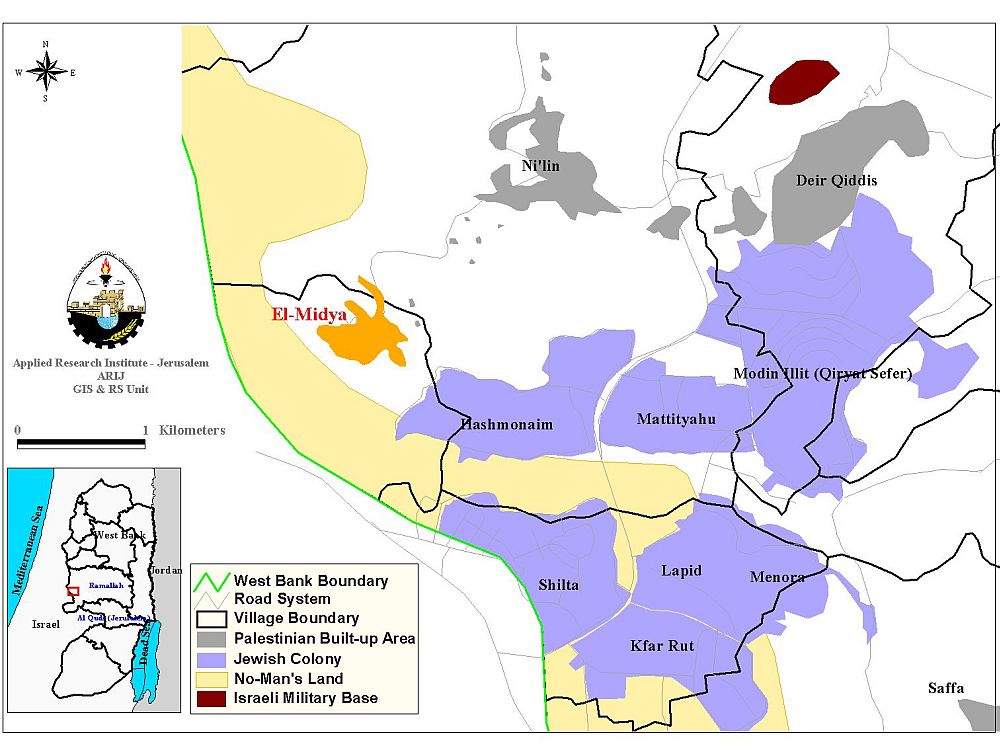
Around 87.1% of Al-Midya village was annexed in 1967 and what remains to the 1200 Palestinian villagers now is about 892.3 dunams from which a 217.78 dunams are considered as a built up area, see table 1. The Israeli court calls for the demolition and the evacuation of 15 houses which belong to 36 households with a total number of 280 persons, which means that quarter of the population is threatened to become homeless. Justifications have been given form the Israeli court of Ramlah stating that there is a legal argue over the ownership of some of these houses while others had no building permits. In addition, some Palestinian villagers were asked to pay a fee for the State of Israel in order to compensate for the usage of their land.  Table 1: Satellite image based analysis of Al Media area annexation, 1967-2003.  

Category

Area (dunams)

Percentage of Annexation

Village boundary area

(1942 British survey)

6959.17

0 %

Area annexed towards Hashmona'im Jewish settlement

101.25

1.4 %


Area annexed to Israel

(Inside the No Man's Land)

1289.64

18.5 %

Area annexed behind the Green line

4675.98

67 %

Total


86.9 %

Source: Arij GIS &RS Unit, 2003.


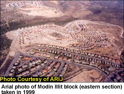
Hashmona'im, one of the largest colonies in Modin block with a population reached to 1955 in the year 2000 established in the year 1985 over Palestinian land belongs to Al-Midya and Na'lin villages, See Photo.


According to the master plan, this block will be the largest city between Jerusalem and Tel Aviv. Based on satellite image analysis (ARIJ GIS 2003), there are 101.25 dunams of the original total area of the village which were confiscated towards Hashmona'im settlement. This colonization of the Palestinian land will block any possibility of the village's southern urban expansion and threaten further confiscation of land as shown in Map 2  . At the same time, the shorter distance between the village built up area and the green line is 730 meters. This fact reveals the continuous policy of land grab used by the successive Israeli governments; Thus, violating the International laws and creating more facts on the ground that will complicate any provisional negotiation over the final status of the West Bank.


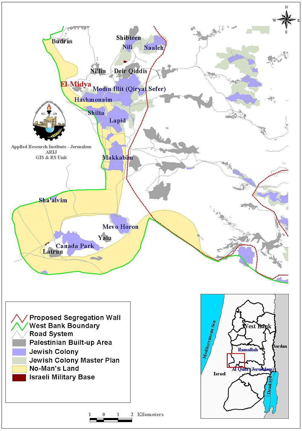
Since 1967, Israel pursued a policy of colonizing Palestine through a settlement policy in an attempt to change its demographic character. Israel has issued various military orders which authorized and facilitated land grab from Palestinians, such as order no. 159 and 291. Exercising pressure of threat such as house demolition and land seizure for military purposes has always been used as an approach to let the Palestinians evacuate their land. Israel is now preparing for constructing the infrastructure of the next steps of erecting the Segregation Wall. An important issue for Israel in the process of preparation is the manipulation over land that the wall will pass through.  Map 2 shows the proposed path of the segregation wall, suggesting the annexation of Modiin block and the surrounding Palestinian localities to Israel behind the Segregation Zone.

Definitely, Al-Midya village will be the second victim of the Israeli devouring of Palestinian land since it is located nearby the No man's land which is considered by Israel as state territories.


Prepared by:  
The Applied Research Institute – Jerusalem

&
Land Research Center-Jerusalem


Recommended For You

Israel Advances Settlement Plan on Ancient Olive Groves on lands of Beit Jala city, Violating International Law and depriving Palestinians their lands

by arij
April 29, 2025
0
Israel Advances Settlement Plan on Ancient Olive Groves on lands of Beit Jala city, Violating International Law and depriving Palestinians their lands

  In late February 2025, Israel has approved a new settlement construction plan on 22.2 dunums of privately owned Palestinian land in the city of Beit Jala, south...

Read moreDetails

Leveraging the Olmert Plan to Safeguard Palestinians amid US Displacement Plans of Gazans to Egypt and Jordan

by arij
February 5, 2025
0
Leveraging the Olmert Plan to Safeguard Palestinians amid US Displacement Plans of Gazans to Egypt and Jordan

  After the ceasefire in the Gaza Strip took effect on January 19, 2025, U.S. President Donald Trump made a highly inhumane statement on January 26, 2025, suggesting...

Read moreDetails

محمية وادي قانا في وجه التهديد الاسرائيلي

by arij
March 26, 2024
0
محمية وادي قانا في وجه التهديد الاسرائيلي

  ان الحرب الإسرائيلية المسعورة ليست محصورة في قطاع غزة المحتل فقط، بل تمتد آثارها إلى الضفة الغربية المحتلة حيث لا تنفك سلطات الاحتلال الإسرائيلي عن استهداف الضفة...

Read moreDetails

إسرائيل تقرر بناء جدار على الحدود الشرقية مع المملكة الأردنية الهاشمية

by arij
October 19, 2023
0
From conflict Resolution to Conflict Management

  انتهاك للسيادة الاردنية وتعزيز السيطرة على الاراضي الفلسطينية وترسيخ الحدود أعلن رئيس وزراء الاحتلال الإسرائيلي في الثالث من شهر أيلول من العام 2023 عن قراره بناء سياج...

Read moreDetails

 “Weaponizing” archaeology in the occupied West Bank, a step towards thwarting Palestinian sovereignty in Area C”

by arij
July 26, 2023
0
 “Weaponizing” archaeology in the occupied West Bank, a step towards thwarting Palestinian sovereignty in Area C”

  The consequences of Israel’s decision to preserve archaeological sites in Area C in the West Bank On July 18, 2023, the Israeli Government gave its approval to...

Read moreDetails
Next Post

House demolition and land seizure in Al Walaja Village in Bethlehem district

LATEST NEWS

الأراضي الفلسطينية بين الذرائع الأمنية والأطماع الاستيطانية – “الأمن، الآثار، والطبيعة كحجج لاقتلاع الفلسطينيين من أراضيهم”

by arij
April 15, 2025
0

........................................................

الطرق الالتفافية الاسرائيلية وأثرها على البيئة الفلسطينية

انتهاك للطبيعة والهوية في الأراضي الفلسطينية المحتلة

by arij
March 17, 2025
0

........................................................

Israel Advances Settlement Plan on Ancient Olive Groves on lands of Beit Jala city, Violating International Law and depriving Palestinians their lands

إسرائيل تمضي قدمًا في مخطط استيطاني جديد على أراضي مدينة بيت جالا، في انتهاك للقانون الدولي وحرمان الفلسطينيين من أراضيهم

by arij
April 29, 2025
0

........................................................

Israel Advances Settlement Plan on Ancient Olive Groves on lands of Beit Jala city, Violating International Law and depriving Palestinians their lands

Israel Advances Settlement Plan on Ancient Olive Groves on lands of Beit Jala city, Violating International Law and depriving Palestinians their lands

by arij
April 29, 2025
0

........................................................

flag_yellow_lowEU-PfP-Logo

This website has been produced with the assistance of the European Union. The contents of this publication are the sole responsibility of ARIJ & LRC and can in no way be taken to reflect the views of the European Union.

© 2025 Copyright ARIJ . All Rights reserved. .

No Result
View All Result
  • Home
  • Settlements
    • New Israeli Settlements
    • Settlement Expansion
  • Israeli Violations
    • Agriculture
    • Confiscation
    • Demolition
    • Environment
    • Eviction of Palestinians
    • Settlers Attacks
  • Bypass Roads
  • Israeli Plans
  • Segregation
    • Checkpoints
    • Closure
    • Separation Plans
  • Military Orders
  • Reports
    • Daily Report
    • Monthly Report
    • Quarterly Report

© 2025 Copyright ARIJ . All Rights reserved. .