• About The Project
  • Palestine in Century
  • Selected Maps
  • Glossary
  • About ARIJ
  • About LRC
  • By Year
    • Case Studies By Year
    • Daily Report By Year
Thursday, October 2, 2025
POICA
No Result
View All Result
  • Home
  • Settlements
    • New Israeli Settlements
    • Settlement Expansion
  • Israeli Violations
    • Agriculture
    • Confiscation
    • Demolition
    • Environment
    • Eviction of Palestinians
    • Settlers Attacks
  • Bypass Roads
  • Israeli Plans
  • Segregation
    • Checkpoints
    • Closure
    • Separation Plans
  • Military Orders
  • Reports
    • Daily Report
    • Monthly Report
    • Quarterly Report
No Result
View All Result
POICA
No Result
View All Result

The Segregation Wall … New map provided for the wall by the IOF

June 16, 2003
in Israeli Plans
The Segregation Wall … New map provided for the wall by the IOF


The Israeli Occupation Forces -IOF- are daily changing the path of the Segregation Wall that is currently under construction in the northern districts of the West Bank and around East Jerusalem. The change of this path always costs the Palestinians more land and provides more facilities especially to the settlers. 

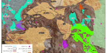
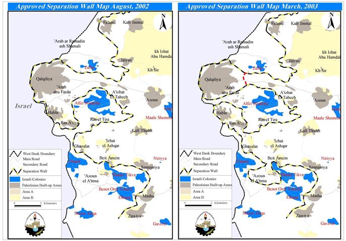
Recently, the IOF issued a map in March 2003 concerning the path of phase I of the Segregation Wall. This map shows tragic changes on the ground especially to the villages of Habla, Ras 'Atiya located to the south of the city of Qalqilya and Qaffin that is located to the north of Tulkrem. According to the route of the Segregation Wall approved in August 2002 Qalqilya, Habla and Ras 'Atiya are found in one 'Ghetto', while as it can be analyzed from the new map provided by the IOF, that the villages of Habla and Ras 'Atiya will be disconnected from the main city of Qalqilya and will be obliged to make a round trip to reach the city. The reason behind this change is that the settlers (about 2,500) living in the settlement of Matan strongly opposed to the old route of the Wall; their main concern is that the settlers of Alfei' Menche will be using a new road that passes through Matan. So, after a long pressure the Israeli Authorities decided to keep the main road that leads the settlers of Alfei Menashe to Israel open and enclave around 6,700 residents of Habla and Ras 'Atiya rendering isolated from their mother city that is Qalqilya.  See Map 1

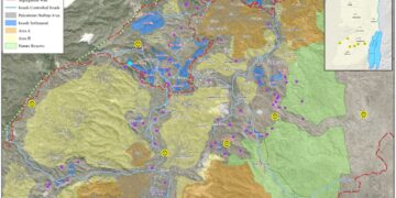
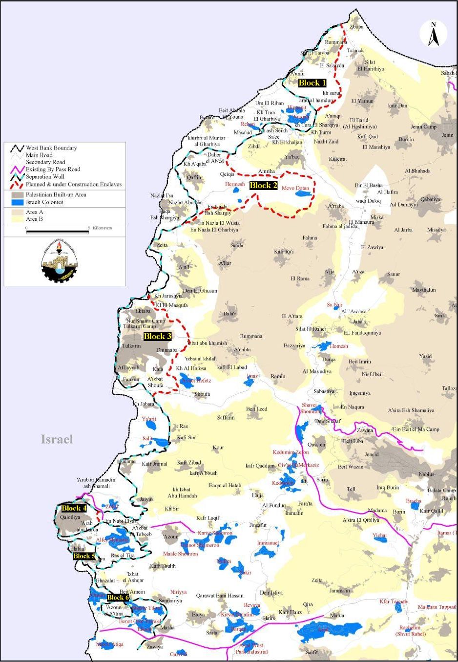
Another fact is that an additional or secondary wall will imprison 21 Palestinian localities into 6 'Ghettos' in the area between the main Segregation Wall and this new secondary wall which will create enclaves as in the case of Qalqiliya where the wall turns into a shape of a bottle. The localities are found in the following table:  Table 1

Block number

Locality

District

Population 2002*

Block 1

At Tayba

Jenin

2,155

Rummana

3,049

As Sa'ida

n.a

'Anin

3,359


Khirbet Suruj.

35 **


'Arab al Hamdun

39 **


8,637

Block 2

Daher al 'Abed 

335

Imreiha

385

Firasin

n.a

'Akkaba

Tulkarm


236

Qaffin

7,901


8,857

Block 3

Tulkarm city

41,109

Tulkarm camp

12,206

Shuweika


Iktaba

1,786

Nur Shams camp

7,133

Far'un

2,884

Izbat Shufa

891


Dhinnaba

7,625


Kafa

315


Khirbet at Tayyah

315


Qeiqis


99 **


74,363

Block 4

Qalqilya city

  Qalqilyia

39,580


39,580

Block 5

Habla

5,445

Ras 'Atiya

1,415


6,860

Block 6

'Azzun 'Atma

1,479


1,479


Total


                                                                         139,776

 Source: ARIJ- GIS Database 2003…
* PCBS 2002 population projections …
PCBS 1997


See Map 2 


Prepared by:  
The Applied Research Institute – Jerusalem

Recommended For You

Annexation of the Jordan Valley: Implications for the Two-State Solution and Regional Stability

by arij
September 29, 2025
0
Annexation of the Jordan Valley: Implications for the Two-State Solution and Regional Stability

  The potential annexation of the Jordan Valley by Israel, emboldened by U.S. President Donald Trump’s second term and supported by Prime Minister Benjamin Netanyahu’s far-right coalition, presents...

Read moreDetails

عزل ثلاث قرى فلسطينية شمال غرب مدينة القدس: الضم الاسرائيلي الصامت يزحف نحو محيط العاصمة

by arij
September 24, 2025
0
Isolation of Three Villages Northwest of Jerusalem: Silent Annexation Creeps toward the Capital

مقدمة في خطوة تجسد سياسة الضم الزاحف التي تنتهجها إسرائيل منذ عقود، وجدت ثلاث قرى فلسطينية تقع إلى الشمال الغربي من مدينة القدس، بيت إكسا، النبي صموئيل، وحي...

Read moreDetails

Isolation of Three Villages Northwest of Jerusalem: Silent Annexation Creeps toward the Capital

by arij
September 24, 2025
0
Isolation of Three Villages Northwest of Jerusalem: Silent Annexation Creeps toward the Capital

Introduction In a move that embodies Israel’s creeping annexation policy pursued for decades, three Palestinian villages located northwest of Jerusalem: Beit Iksa, Nabi Samuel, and Al-Khalaila, suddenly found...

Read moreDetails

سياسات التهويد في القدس: من السيطرة المكانية إلى طمس الهوية عبر التسمية

by arij
September 23, 2025
0
سياسات التهويد في القدس: من السيطرة المكانية إلى طمس الهوية عبر التسمية

المقدمة تشكل سياسات تغيير الأسماء إحدى الأدوات الأكثر عمقا وخطورة في المشروع الاستعماري الإسرائيلي، إذ لا تقتصر على البعد الإداري أو التقني، بل تمتد إلى جوهر الهوية والذاكرة...

Read moreDetails

Judaization Policies in Jerusalem:  From Spatial Control to Identity/ Naming Theft

by arij
September 23, 2025
0
Judaization Policies in Jerusalem:  From Spatial Control to Identity/ Naming Theft

Introduction The policy of changing place names represents one of the most profound and dangerous tools in the Israeli colonial project. It extends beyond administrative or technical concerns...

Read moreDetails
Next Post
Ras Al Amoud Neighborhood: A hot spot in occupied East Jerusalem

Ras Al Amoud Neighborhood: A hot spot in occupied East Jerusalem

LATEST NEWS

Annexation of the Jordan Valley: Implications for the Two-State Solution and Regional Stability

Annexation of the Jordan Valley: Implications for the Two-State Solution and Regional Stability

by arij
September 29, 2025
0

........................................................

Isolation of Three Villages Northwest of Jerusalem: Silent Annexation Creeps toward the Capital

عزل ثلاث قرى فلسطينية شمال غرب مدينة القدس: الضم الاسرائيلي الصامت يزحف نحو محيط العاصمة

by arij
September 24, 2025
0

........................................................

Isolation of Three Villages Northwest of Jerusalem: Silent Annexation Creeps toward the Capital

Isolation of Three Villages Northwest of Jerusalem: Silent Annexation Creeps toward the Capital

by arij
September 24, 2025
0

........................................................

سياسات التهويد في القدس: من السيطرة المكانية إلى طمس الهوية عبر التسمية

سياسات التهويد في القدس: من السيطرة المكانية إلى طمس الهوية عبر التسمية

by arij
September 23, 2025
0

........................................................

flag_yellow_lowEU-PfP-Logo

This website and its content were initiated in 1993 by the Applied Research Institute – Jerusalem (ARIJ) and the Land Research Center (LRC) with the support from the European Union up until 2023. Since then, the Applied Research Institute – Jerusalem (ARIJ) has taken over the continued development and maintenance of the website. The views expressed remain solely those of ARIJ) and do not necessarily reflect those of the European Union.

© 2025 Copyright ARIJ . All Rights reserved. .

No Result
View All Result
  • Home
  • Settlements
    • New Israeli Settlements
    • Settlement Expansion
  • Israeli Violations
    • Agriculture
    • Confiscation
    • Demolition
    • Environment
    • Eviction of Palestinians
    • Settlers Attacks
  • Bypass Roads
  • Israeli Plans
  • Segregation
    • Checkpoints
    • Closure
    • Separation Plans
  • Military Orders
  • Reports
    • Daily Report
    • Monthly Report
    • Quarterly Report

© 2025 Copyright ARIJ . All Rights reserved. .