• About The Project
  • Palestine in Century
  • Selected Maps
  • Glossary
  • About ARIJ
  • About LRC
  • By Year
    • Case Studies By Year
    • Daily Report By Year
Friday, October 3, 2025
POICA
No Result
View All Result
  • Home
  • Settlements
    • New Israeli Settlements
    • Settlement Expansion
  • Israeli Violations
    • Agriculture
    • Confiscation
    • Demolition
    • Environment
    • Eviction of Palestinians
    • Settlers Attacks
  • Bypass Roads
  • Israeli Plans
  • Segregation
    • Checkpoints
    • Closure
    • Separation Plans
  • Military Orders
  • Reports
    • Daily Report
    • Monthly Report
    • Quarterly Report
No Result
View All Result
POICA
No Result
View All Result

The Israeli Security Zones make up 45.25% of the West Bank Including 158 Israeli Settlements

June 18, 2002
in Israeli Plans
The Israeli Security Zones make up 45.25% of the West Bank Including 158 Israeli Settlements


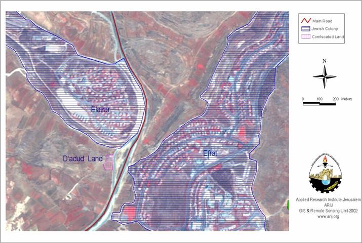
After further inquiry, field work investigation and map analysis, the Applied Research Institute- Jerusalem has succeeded to draw a map of Sharon's actual motive behind his security plan in the West Bank, that of creation of an apartheid system in the territories.

West Bank Map Analysis

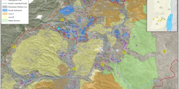
Besides the Israeli closure policy imposed on Palestinian town and cities since the beginning of Al-Aqsa Intifada two years ago, the West Bank- according to the new separation policy- will be fragmented into 8 blocks, creating 64 Palestinian ghettos. These ghettos are surrounding by 46 permanent checkpoints and 126 roadblocks. From May 2002, Israel started to implement an apartheid regime, Palestinian residents need special permits issued by the Israeli Civil Administration, Israeli's military government (as those 'passbooks' used in South Africa), for travel between Palestinian cities and cantons within the West Bank and Gaza.

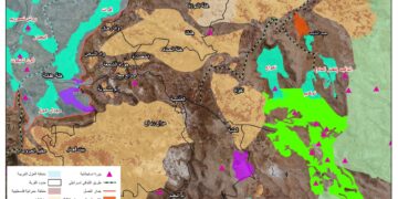
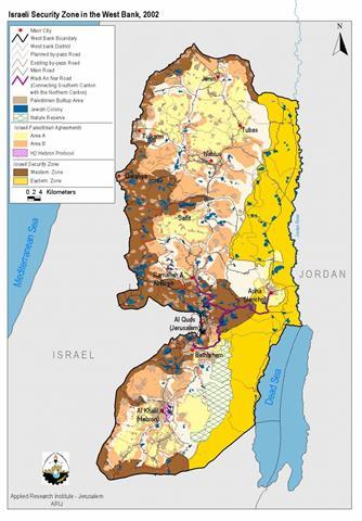
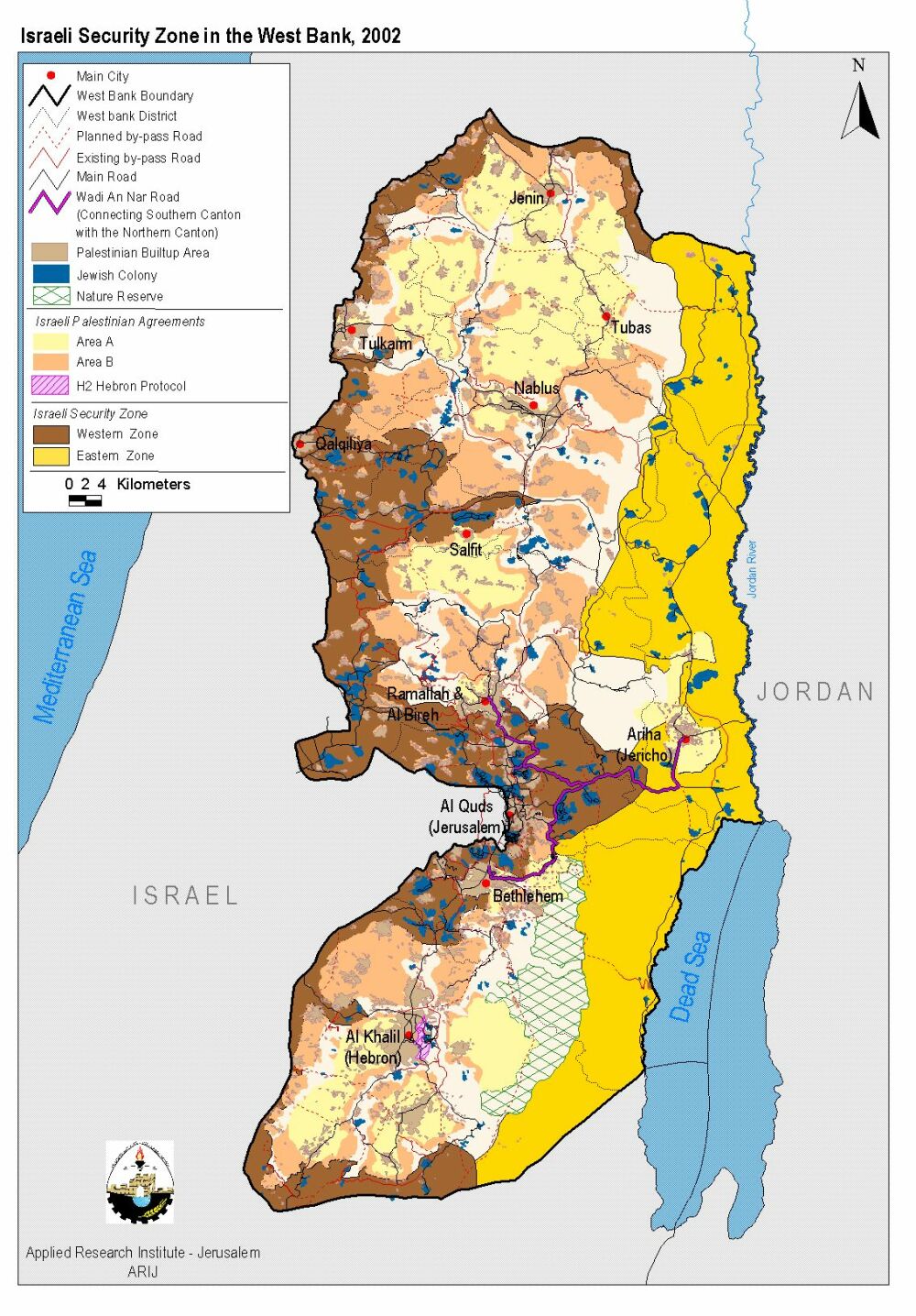
According to Sharon's military plan of separation, the West Bank will be divided into three longitudinal slices: Western-Northern Security Slice, Eastern Security Slice and the Remaining Palestinian areas in the middle. See map

  • The Western-Northern Security Slice (red in map)- extends alongside the 'Green line' from the Palestinian city of Jenin in the northern boundaries of the West Bank down to Hebron in the south. This security zone has a total area of 1328 Km2, which is 23.4% of total area of the West Bank. Also, it will enclose 118 Israeli settlements.

  • The Eastern Security Slice (yellow in map)- includes the Jordan Valley and the shores of the Dead Sea with a total area of 1237 Km2 (21.9 % of the West Bank); 40 Israeli settlements are included within boundaries of this zone.

  • The Remaining Palestinian area– includes main urban Palestinian cites (Area A) and part of Area B. This area is already fragmented into 64 ghettos, surrounded by 46 Israeli permanent checkpoints and 126 roadblocks. The total area of this fragmented region is 3096 Km2, which amounts to 54 % of the total area of the West Bank.  The table below summarizes the above-mentioned data:

Total area of the Security zones

2565 Km2 (45.25 % of West Bank Total Area)

Total area of the remaining Palestinian area

3096 Km2

Total number of Israeli settlements inside the security zones

158 (-out of 223 Israeli settlements)

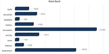
Palestinian population inside security zones

267,700* (17 % of total Palestinian population in the West Bank)

 Source: Applied Research Institute, GIS Database, 2002

*1997 Palestinian Census (Palestinian Central Bureau of Statistics).


Prepared by:
The Applied Research Institute – Jerusalem

Recommended For You

Annexation of the Jordan Valley: Implications for the Two-State Solution and Regional Stability

by arij
September 29, 2025
0
Annexation of the Jordan Valley: Implications for the Two-State Solution and Regional Stability

  The potential annexation of the Jordan Valley by Israel, emboldened by U.S. President Donald Trump’s second term and supported by Prime Minister Benjamin Netanyahu’s far-right coalition, presents...

Read moreDetails

عزل ثلاث قرى فلسطينية شمال غرب مدينة القدس: الضم الاسرائيلي الصامت يزحف نحو محيط العاصمة

by arij
September 24, 2025
0
Isolation of Three Villages Northwest of Jerusalem: Silent Annexation Creeps toward the Capital

مقدمة في خطوة تجسد سياسة الضم الزاحف التي تنتهجها إسرائيل منذ عقود، وجدت ثلاث قرى فلسطينية تقع إلى الشمال الغربي من مدينة القدس، بيت إكسا، النبي صموئيل، وحي...

Read moreDetails

Isolation of Three Villages Northwest of Jerusalem: Silent Annexation Creeps toward the Capital

by arij
September 24, 2025
0
Isolation of Three Villages Northwest of Jerusalem: Silent Annexation Creeps toward the Capital

Introduction In a move that embodies Israel’s creeping annexation policy pursued for decades, three Palestinian villages located northwest of Jerusalem: Beit Iksa, Nabi Samuel, and Al-Khalaila, suddenly found...

Read moreDetails

سياسات التهويد في القدس: من السيطرة المكانية إلى طمس الهوية عبر التسمية

by arij
September 23, 2025
0
سياسات التهويد في القدس: من السيطرة المكانية إلى طمس الهوية عبر التسمية

المقدمة تشكل سياسات تغيير الأسماء إحدى الأدوات الأكثر عمقا وخطورة في المشروع الاستعماري الإسرائيلي، إذ لا تقتصر على البعد الإداري أو التقني، بل تمتد إلى جوهر الهوية والذاكرة...

Read moreDetails

Judaization Policies in Jerusalem:  From Spatial Control to Identity/ Naming Theft

by arij
September 23, 2025
0
Judaization Policies in Jerusalem:  From Spatial Control to Identity/ Naming Theft

Introduction The policy of changing place names represents one of the most profound and dangerous tools in the Israeli colonial project. It extends beyond administrative or technical concerns...

Read moreDetails
Next Post
Agricultural Land confiscation Near Elazar Settlement

Agricultural Land confiscation Near Elazar Settlement

LATEST NEWS

Annexation of the Jordan Valley: Implications for the Two-State Solution and Regional Stability

Annexation of the Jordan Valley: Implications for the Two-State Solution and Regional Stability

by arij
September 29, 2025
0

........................................................

Isolation of Three Villages Northwest of Jerusalem: Silent Annexation Creeps toward the Capital

عزل ثلاث قرى فلسطينية شمال غرب مدينة القدس: الضم الاسرائيلي الصامت يزحف نحو محيط العاصمة

by arij
September 24, 2025
0

........................................................

Isolation of Three Villages Northwest of Jerusalem: Silent Annexation Creeps toward the Capital

Isolation of Three Villages Northwest of Jerusalem: Silent Annexation Creeps toward the Capital

by arij
September 24, 2025
0

........................................................

سياسات التهويد في القدس: من السيطرة المكانية إلى طمس الهوية عبر التسمية

سياسات التهويد في القدس: من السيطرة المكانية إلى طمس الهوية عبر التسمية

by arij
September 23, 2025
0

........................................................

flag_yellow_lowEU-PfP-Logo

This website and its content were initiated in 1993 by the Applied Research Institute – Jerusalem (ARIJ) and the Land Research Center (LRC) with the support from the European Union up until 2023. Since then, the Applied Research Institute – Jerusalem (ARIJ) has taken over the continued development and maintenance of the website. The views expressed remain solely those of ARIJ) and do not necessarily reflect those of the European Union.

© 2025 Copyright ARIJ . All Rights reserved. .

No Result
View All Result
  • Home
  • Settlements
    • New Israeli Settlements
    • Settlement Expansion
  • Israeli Violations
    • Agriculture
    • Confiscation
    • Demolition
    • Environment
    • Eviction of Palestinians
    • Settlers Attacks
  • Bypass Roads
  • Israeli Plans
  • Segregation
    • Checkpoints
    • Closure
    • Separation Plans
  • Military Orders
  • Reports
    • Daily Report
    • Monthly Report
    • Quarterly Report

© 2025 Copyright ARIJ . All Rights reserved. .