Located on the Mediterranean Sea bordering Egypt and Israel, the Gaza Strip is home to about 1,087,000 Palestinians. The total area of the Strip is 363,800 dunums (363.8 km²). It is one of the most overcrowded areas in the world. Agriculture is the main economic activity in the Gaza Strip. Main agricultural products include dates and citrus fruits in addition to different types of vegetables.
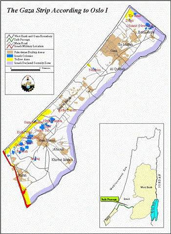
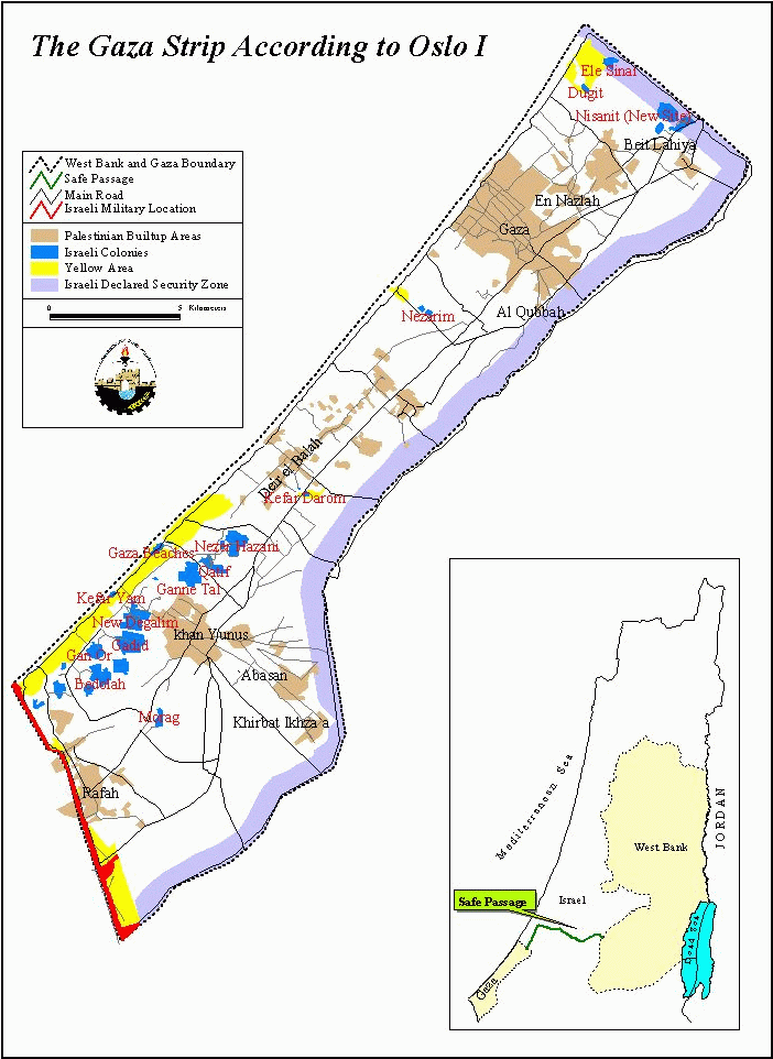
In 1994, the Oslo I accords were signed. In these accords, the city of Jericho and the majority of the Gaza Strip were returned to Palestinian control. However, parts of Gaza continued to be controlled by Israel. These areas include the settlements, the border of Gaza and Egypt, a security zone along the border of Gaza and Israel proper, and the Yellow area. The Yellow area operates similar to area B in the West Bank, where the Palestinian Authority has jurisdiction over civil affairs while Israel controls security. But in the Yellow area the Palestinian National Authorities power is more limited than in area B in the West Bank; see map 1.
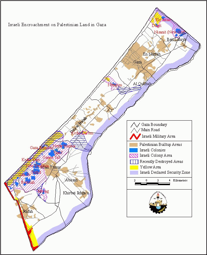
Since the beginning of the Al-Aqsa Intifada, in addition to tightening the internal and external closures in the Strip (for more click here), the Israeli military and settlers have stepped up their actions of confiscating and destroying Palestinian land and property. Despite the small area of the Strip, its high population density, and the fact that there are a great number of Palestinian refugee camps, Israeli built-up areas continue to grow. Table1 describes the land use in the Gaza Strip by area.
Table1: Land use in the Gaza Strip
|
Type |
Area in km.² |
|
Palestinian built-up areas |
50.86 |
|
Israeli settlement built-up areas |
12.65 |
|
Israeli military bases and security zones |
61.65 |
ARIJ database 1999
There are 19 colonies in the Gaza Strip. Their geographical distribution is designed to accomplish two goals:
1. To prevent, as much as possible, Palestinian centers from reaching the Mediterranean Sea. This goal has been achieved through the establishment of 16 colonies parallel to the Mediterranean Sea in the south of the Strip.
2. To control the main roads that divide the Strip into three distinct areas that allow for their easy isolation. This goal has been achieved through the establishment of the 3 colonies of Erez in the north, Kfar Darom in the middle of the Strip, and Morag in the south; see map2 .
The settlements include military bases that aim to maintain military and security control over the Strip with a particular focus on its coastal area and the Egyptian border. There are also a number of agricultural settlements to which large areas of land have been annexed and used as farms. The agricultural settlements exploit the water supply of the Gaza Strip and are used to grow specialized crops such as flowers. In addition, there are a number of industrial settlements with the aim of utilizing cheap labor in the Gaza Strip to produce Israeli products for local and international markets.
A large network of roads has been built to serve Israeli settlements. The roads fall in two categories:
1. Regional roads that connect the three settlement blocks in the south, north and center of the occupied land with Israel proper.
2. Roads connecting settlements to each other and connecting settlements to regional roads; see map2 . .
The Israelis enforce security control over these roads, using military checkpoints and roadblocks. Often, the Israeli army and colonists prevent Palestinians from using the roads, particularly since the closure imposed since early October.
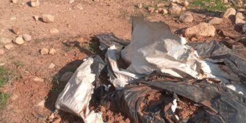
For Palestinians, the construction and expansion of Jewish settlements and the roads that serve them mean the loss of land and home. Farmers have been hit particularly hard since their land is their livelihood. Even in the unlikely scenario that these farmers get their land back, it will take many years to replace the trees and greenhouses that the occupation forces have destroyed. From September 29, 2000 to February 14, 2001 alone the occupation forces razed 7,024 dunums (7.024 km.²) of land in the Gaza Strip. Of this area, about 5,494 dunums (78.2%) were agricultural land while about 1,530 dunums (21.8%) were wooded or other unplanted areas. In the same period 94 Palestinian houses were completely demolished, leaving over 450 people without homes. Many of these people must move in with family members, thus increasing the already crowded conditions. These numbers reveal a frightening increase in the level of colonizing activity compared to that in the months previous to the Al-Aqsa Intifada.
Map2 shows where the majority of this destruction has taken place. The bulk of the colonizing activity continues around these areas. It is clear that the strategy of land confiscation and property destruction compliments the goals of settlement expansion sited above. Over the years, more and more land has been confiscated around the settlement built-up areas, designated by the purple hash marks. The blue hash marks indicate those areas the Israeli occupation forces have destroyed in the past six months. shows where the majority of this destruction has taken place. The bulk of the colonizing activity continues around these areas. It is clear that the strategy of land confiscation and property destruction compliments the goals of settlement expansion sited above. Over the years, more and more land has been confiscated around the settlement built-up areas, designated by the purple hash marks. The blue hash marks indicate those areas the Israeli occupation forces have destroyed in the past six months.
The pattern behind the razing of land clears the way for further merging between the settlements in the south. The destruction of land and homes in the area between the southern settlements and the sea will, in the future, ensure exclusive Israeli use of that stretch of coastline. Destruction of Palestinian property has gone in this coastline area for some time and has continued in the past six months. It is difficult to document exactly when and where the destruction has taken place, however, because the area is heavily restricted. The Israeli forces have also razed much land along the main roads in order to reinforce their control of these roads. This last point is particularly significant in supporting the current internal and external closure on the Gaza Strip; for more click here. It is also important to note that much of the razed land is located in areas that the Palestinians, according the Oslo accords, are suppose to be in full control of.
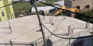
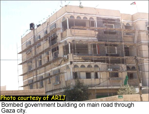
In addition to the bulldozing and confiscation of Palestinian land and houses, the Palestinians in the Gaza Strip have been subject to almost nightly bombardment by the Israeli military. Israeli guns, tanks and helicopters fire indiscriminately into residential areas, destroying buildings and injuring or killing their inhabitants. Hundreds of Palestinian homes have been damaged in this way, almost 250 in October, 2000 alone. Occupation forces have attacked industrial and commercial buildings as well, causing millions of dollars worth of damage and increasing the already high unemployment rate. Furthermore, public premises have been attacked, sometimes targeted intentionally, including police stations, hospitals, schools, PA security forces bases, government offices and religious facilities, see photo.
Because of its small area and high population density, the situation in the Gaza Strip is quite tense. This does not stop the Israeli colonizing forces from extending their presence and control into ever-larger areas of the Strip. International law forbids an occupying power from destroying or taking the property of the occupied except in the case of immediate military necessity. It is clear that the colonizing activities of the Israeli occupational forces are not motivated by such military necessity, but instead by the desire to dispossess the Palestinian land from its owners.
This report was written with data compiled by the Al-Mezan Center for Human Rights and the Palestinian Center for Human Rights.
Prepared by:
The Applied Research Institute – Jerusalem