• About The Project
  • Palestine in Century
  • Selected Maps
  • Glossary
  • About ARIJ
  • About LRC
  • By Year
    • Case Studies By Year
    • Daily Report By Year
Saturday, May 17, 2025
POICA
No Result
View All Result
  • Home
  • Settlements
    • New Israeli Settlements
    • Settlement Expansion
  • Israeli Violations
    • Agriculture
    • Confiscation
    • Demolition
    • Environment
    • Eviction of Palestinians
    • Settlers Attacks
  • Bypass Roads
  • Israeli Plans
  • Segregation
    • Checkpoints
    • Closure
    • Separation Plans
  • Military Orders
  • Reports
    • Daily Report
    • Monthly Report
    • Quarterly Report
No Result
View All Result
POICA
No Result
View All Result

The Withdrawal Percentages, What Do They Really Mean?

January 3, 2001
in Reports
The Withdrawal Percentages, What Do They Really Mean?


Lately there has been a lot of talk about the percentage of land the Israelis are 'willing' to withdraw from in the West Bank. And these percentages have caused a lot of confusion and ambiguity. The idea of dividing the withdrawals into percentages was first introduced in the Wye River Memorandum.

Unlike Oslo II, the Wye River Memorandum and the Sharm El-Sheikh Memorandum mention percentages of redeployments without negotiating with the Palestinian side where those redeployments should take place. For example, the Wye River Memo states that 3% should be 'Nature Reserves' and that 'Israeli officials acquaint their Palestinian counterparts as required with areas..,' while the Sharm El-Sheikh Memo doesn't mention the Nature Reserves and succinctly talks of percentage 'transfers.' This meant that Israeli officials would supply maps of the withdrawals only after the signing of the agreement. Here is the sequence of withdrawals in the West Bank (excluding Gaza) since Oslo II, which took place in 1995. Table 1: The Redeployment Sequence according to the agreements.

Agreement

Stages

Area A

Area B

Area C

Oslo II

3.0 %

24.0 %

73.0 %

Wye River

I

10.1 %

18.9 %

71.0 %

II & III (not implemented)

18.2 %

21.8 %

60.0 %

Sharm El-Sheikh

I

10.1 %

25.9 %

64.0 %

II (implemented in delay)

12.1 %

26.9 %

61.0 %

III (implemented in delay)

18.2 %

21.8 %

60.0 %


On the ground, area A comprises 1004 sq. km of the West Bank. In area B, the Palestinians have full control over civil society except that Israel continues to have overriding responsibility for security. These areas constitute now 1204.4 sq. km of the West Bank. In area C, Israel retains full control over land, security, people and natural resources. The jagged distribution of yellow and blue areas in the Gaza strip and areas A, B, C, H1 and H2 has partitioned the West Bank and Gaza into isolated cantons, which are physically separated from each other.

By dividing the area A over the overall area of the West Bank occupied in 1967 , the actual percentage of Area A comes to 17.15 % of the West Bank area. However, according to the Sharm El-Sheikh Memo, the percentage of Area A should have been 18.2 %. By the same token, the actual percentage of Area B amounts to 20.57 % of the West Bank whereas according to the Sharm El-Sheikh Memo, the percentage of Area B should have been 21.8%.

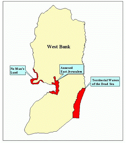
This discrepancy comes from the fact that Israel omits certain parts of the West Bank when calculating the area of the West Bank. Those parts are:

Territory

Area in sq. km

No Man's Land

50

Annexed East Jerusalem

71

Territorial Waters of the Dead Sea

195

Total

316


West Bank Area

5854

Israel's Omissions

316

West Bank Area according to Israel

5538


Thus, quite to the convenience of the Israelis, the percentage transfers appear larger than what they really are because they are calculated over a smaller patch of land. This is what happened when the Israelis claimed a 7 % withdrawal in Sharm El-Sheikh while actually it amounted to only 6.56 %. 

Figure 1: Territories that Israel omits from the West Bank's area.


Israel's hidden objective behind this discrepancy is to create the impression that the omitted areas are not part of the West Bank. That the No Man's Land, The territorial waters of the Dead Sea, and the annexed part of Jerusalem are beyond the scope of the legitimate rights of the Palestinians.


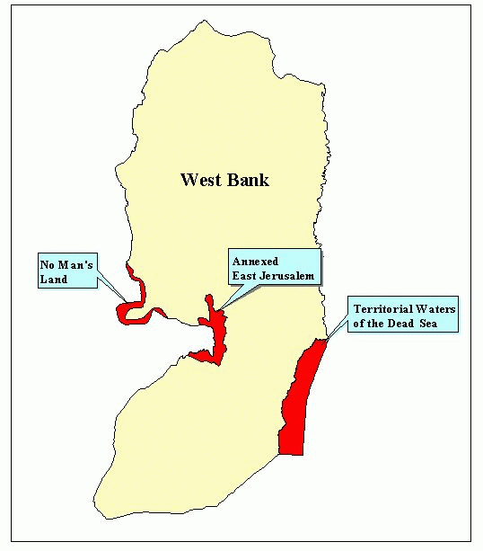
This scheme is continuing now during the deliberations concerning Israeli proposals for final status withdrawals. At first, Israel proposed a withdrawal from 85 % of the West Bank while annexing the remaining 15 %. Then that figure changed to 90 % and finally the highest proposed withdrawal has been 94 %. Here again the game of calculating the percentages is put into practice in order to amplify Israel's 'generosity'. An Israeli '94 %' withdrawal in effect corresponds to 88.9 % of the West Bank's actual area. Furthermore, if one considers that Israel is planning to annex some 220 sq. km from the West Bank as part of 'Greater Jerusalem' than that famous 94 % shrinks to 86.5 %. This way Israel gets to keep a sizeable portion of the West Bank while appearing as though it were relinquishing almost all of it.

Territory

Area in sq. km

No Man's Land

50

Area Israel wants to annex as part of 'Greater Jerusalem'

220

Territorial Waters of the Dead Sea

195

Total

465


West Bank Area

5854

Israel's Omissions

465

West Bank Area according to Israel

5389


Prepared by:
The Applied Research Institute – Jerusalem

Recommended For You

It might look “Far-off”; the Two-State Solution remains the optimal solution for addressing the conflict

by arij
December 9, 2023
0
It might look “Far-off”; the Two-State Solution remains the optimal solution for addressing the conflict

  Preamble Facing the distressing images of bombings, destruction, killings, and the forced displacement of Palestinians since October 7, 2023, poses a significant challenge to the Palestinian people...

Read moreDetails

Monitoring Report on the Israeli Settlement Activities in the occupied State of Palestine – September 2023

by arij
October 31, 2023
0

  The monthly report highlights the violations behind Israeli home demolitions and demolition threats in the occupied Palestinian territory, the confiscation and razing of lands, the uprooting and...

Read moreDetails

Monitoring Report on the Israeli Settlement Activities in the occupied State of Palestine – August 2023

by arij
October 26, 2023
0

  The monthly report highlights the violations behind Israeli home demolitions and demolition threats in the occupied Palestinian territory, the confiscation and razing of lands, the uprooting and...

Read moreDetails

Monitoring Report on the Israeli Settlement Activities in the occupied State of Palestine – July 2023

by arij
October 26, 2023
0

  The monthly report highlights the violations behind Israeli home demolitions and demolition threats in the occupied Palestinian territory, the confiscation and razing of lands, the uprooting and...

Read moreDetails

Monitoring Report on the Israeli Settlement Activities in the occupied State of Palestine – June 2023

by arij
July 27, 2023
0

  The monthly report highlights the violations behind Israeli home demolitions and demolition threats in the occupied Palestinian territory, the confiscation and razing of lands, the uprooting and...

Read moreDetails
Next Post
Moving Checkpoints Eastwards – settlements Effectively Annexed

Moving Checkpoints Eastwards - settlements Effectively Annexed

LATEST NEWS

Expansion of Gilo Settlement: A Strategic Plan to Isolate Bethlehem and Undermine Palestinian Rights

Expansion of Gilo Settlement: A Strategic Plan to Isolate Bethlehem and Undermine Palestinian Rights

by arij
May 12, 2025
0

........................................................

الأراضي الفلسطينية بين الذرائع الأمنية والأطماع الاستيطانية – “الأمن، الآثار، والطبيعة كحجج لاقتلاع الفلسطينيين من أراضيهم”

by arij
April 15, 2025
0

........................................................

الطرق الالتفافية الاسرائيلية وأثرها على البيئة الفلسطينية

انتهاك للطبيعة والهوية في الأراضي الفلسطينية المحتلة

by arij
March 17, 2025
0

........................................................

Israel Advances Settlement Plan on Ancient Olive Groves on lands of Beit Jala city, Violating International Law and depriving Palestinians their lands

إسرائيل تمضي قدمًا في مخطط استيطاني جديد على أراضي مدينة بيت جالا، في انتهاك للقانون الدولي وحرمان الفلسطينيين من أراضيهم

by arij
April 29, 2025
0

........................................................

flag_yellow_lowEU-PfP-Logo

This website has been produced with the assistance of the European Union. The contents of this publication are the sole responsibility of ARIJ & LRC and can in no way be taken to reflect the views of the European Union.

© 2025 Copyright ARIJ . All Rights reserved. .

No Result
View All Result
  • Home
  • Settlements
    • New Israeli Settlements
    • Settlement Expansion
  • Israeli Violations
    • Agriculture
    • Confiscation
    • Demolition
    • Environment
    • Eviction of Palestinians
    • Settlers Attacks
  • Bypass Roads
  • Israeli Plans
  • Segregation
    • Checkpoints
    • Closure
    • Separation Plans
  • Military Orders
  • Reports
    • Daily Report
    • Monthly Report
    • Quarterly Report

© 2025 Copyright ARIJ . All Rights reserved. .