Rantis is a Palestinian village located 9 km northwest of Ramallah city. Rantis has suffered much under the Israeli occupation. On two occasions since 1967, the village has been subjected to land confiscations with a total of 3,500 dunums (350 hectares) having been confiscated (1,500 of these were in 1991 for the building of Ofarim settlement). In 1997 the Israeli army uprooted some of the village's olive trees under the alleged reason of demarcating the 1949 Armistice Line more clearly. At the same time, the old police station was confiscated and an Israeli gas station and restaurant were built on village lands. Nowadays, Rantis has around 3000 residents from 405 households. Most of the village's working force is employed in Israel.
Since January 2001, the Israeli army has begun to move numbers of Israeli checkpoints towards the east. The shifting of checkpoints may be in preparation to annex numbers of Israeli settlements settlement and may also eventually entail the annexing of nearby Palestinian villages so as to isolate Israel from the West Bank. Click for more details of other checkpoint movements. Only 1 km separates the West Bank border from the main entrance to the Palestinian village of Rantis. Previously, the Rantis checkpoint was located between the border and the entrance to the village; see map. This roadblock has now been moved 2 km eastward, past the entrance to the village. Thus, the villagers can only travel between the village and the rest of the West Bank at the will of the Israeli soldiers.
Since the beginning of the blockade, examples of hardship faced by villagers across the West Bank have been almost countless. The first Rantis villager to feel the effects of the new checkpoint was a 35 years old auditor working in Ramallah. On approaching the village on his way home from work, he came across the new checkpoint, where a number of Israeli soldiers were positioned who hindered him from entering. When he asked them: ''how can I get to my village'', they answered; ''this is not our concern''. They told him, ''you have to forget Rantis''.
Since that time, all the villagers have had to traverse an alternative, unpaved road that takes 35 minutes to reach their village. On January 3, 2001, the Israeli army prevented the use of this alternative route, leaving those wishing to travel to the West Bank for shopping, medical facilities, visiting relatives or work, with no other option than to take far more arduous routes. On the same day, Taysir Dahan died on his way to the doctor because of the long journey. He was diagnosed to have had a heart attack.
There is one possible exit from Rantis which involves taking a long agricultural track. Sometimes, an Israeli roadblock is installed near A'aboud village, when this roadblock is in place villagers are virtually unable to reach or leave their village by vehicle. One worker managed to find a very long route with a journey time of four hours between Rantis and Ramallah. Under normal conditions, Rantis is about half an hour's drive from Ramallah; see map.
The difficulties faced by Rantis villagers as a result of the Israeli army blockade can be found repeated in other villages all across Ramallah district.
-
A roadblock and a ditch have been established in El Nabi Saleh village. This block means that villagers from El Nabi Saleh, Kafr E'in, and Qarawat Bani Zeid who used to travel to Ramallah by joining the 465 road in El Nabi Saleh can no longer take this route. Instead, they must travel to Salfit in the north then to Mazare' En Nubani, A'arura, A'bwein and Jilijliya. Those who worry less about their car's maintenance take a dirt track from Qarawat Bani Zeid to Mazare' En Nubani in order to shorten the distance. When in Jilijliya it is necessary to take dirt tracks to avoid the blockades at Sinjil village (see Figure 4). From here they can either risk settler attacks by joining the by-pass road, route 60, or they can cross this road towards Turmas A'yya. From here they must travel to Deir Jarir, Deir Dibwan, Beitin, 'Ein Yabrud, Dura Al Qar', Al Jalazon camp and then into Ramallah.
-
During the Feast at the end of Ramadan, Palestinian villagers of El Nabi Saleh, Kafr E'in and Qarawat Bani Zeid opened narrow holes in the roadblocks erected at the entrances of their villages. For a while the Israeli army disregarded these acts. Unfortunately, several days later, Israeli bulldozers were brought in to reinstate the blocks.
-
On December 5, 2001, on the Nablus-Jerusalem road in the area between Nablus and Ramallah, two blocks have been imposed by the Israeli army close to Beit El entrance. Thus all Palestinian cars have to take bumpy roads via El Jalazon village in order to reach Ramallah.
-
A new roadblock with cement blocks were set up at E'in Qinya on the Ramallah-El Tira side.
-
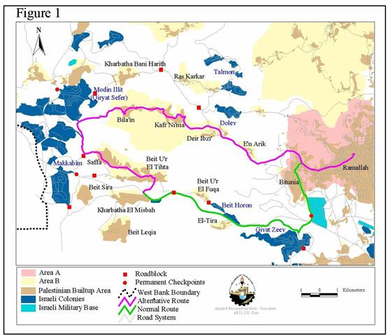
The Israeli army has placed a roadblock at the entrance to Beit U'r El Tihta village. Due to this blockade, these villagers can only reach Ramallah if they travel via Saffa, Bila'in and 'Ein Arik villages; see Figure 1. .
-
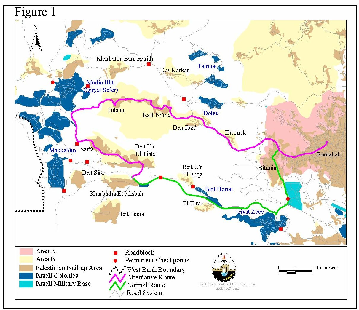
Since the blockade, a villager from the western edge of the West Bank wishing to travel to Ramallah (the main city in the district) has only two options. One alternative is to drive to Khabatha Bani Harith and leave the car there. Then they must walk over the fields to Bila'in village and from there take public transport to Ramallah. The other alternative is to drive via Ni'lin, Shuqba, Hallamish settlement, Ateret settlement, E'in Sinya, Bet El settlement and then El Bireh-Ramallah; see Figure 2. .
-
The by-pass road, route 60, crosses over the road between E'in Yabroud and Silwad villages by means of a bridge. A roadblock and a large amount of cement blocks have been established beneath this bridge. Villagers can't pass by these blocks due to their size. Therefore, villagers of El Mazra'a Esh Sharqiya, Silwad, Kafr Malik, Deir Jarir, El Taybeh and Rammun wishing to reach Ramallah have to pass by Deir Dibwan village. There is a roadblock between Beitin and E'in Yabroud villages, but a small gap has been opened by the villagers through which cars can pass with difficulty. After reaching E'in Yabroud the villager must continue on to Dura El Qare' village by dirt tracks. Again here there is another roadblock, but a small gap has also been made in it. Then the journey continues to El Jalazon refugee camp. But opposite Beit El settlement, two roadblocks are found. A bumpy way can be taken to avoid these blocks and to finally reach the northern entrance of Al-Bireh. Figure 3.

-
El Janiya-Ras Karkar: – Due to the total blockade imposed on these villages, villagers have to walk over the fields to Kafr Ni'ma in order to reach Ramallah.
-
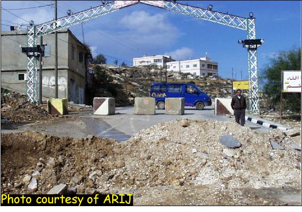
Sinjil: – This village is currently besieged and suffers from frequent curfews; see photo. .
|
Route |
Normal Distance in km |
Distance After the Blockade in km |
|
An Nabi Saleh – Ramallah |
21 |
74 |
|
Kharbatha El Misbah – Ramallah |
18 |
27 |
|
Beit Ur El Tihta – Ramallah |
18 |
26 |
|
Kharbatha Bani Harith – Ramallah |
17 |
50 |
|
El Mazra'a Esh Sharqiya – Ramallah |
22 |
40 |
The road blockade and military checkpoints have had a severe impact on the daily lives of ordinary Palestinians. Under the pretence of ''security'' the Israeli authorities are making it very difficult for Palestinians to commute between villages and towns and thus diminishing their access to vital services and economic resources. The intention is to exhaust the Palestinians into submission and adherence to Israel's designs for the West Bank.
Prepared by:
The Applied Research Institute – Jerusalem


