Introduction:
Jerusalem is considered to be the epic center of Palestinian polity, culture, economic and spirituality. Such significance came as Jerusalem is at the heart and the capital of historical Palestine. Its area is about 342 squared kilometers and it is inhabited by more than 20 thousand Palestinians. Recently, it has been the stage of continued Israeli attacks ever since Al Aqsa Intifada started on its soil on the 29th of September 2000. The latest reports indicates that Jerusalem witnessed the martyrdom of 13 people since late September in addition to more than 700 wounded and 400 imprisoned by the Israeli army.
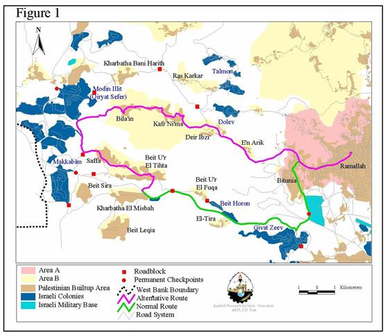
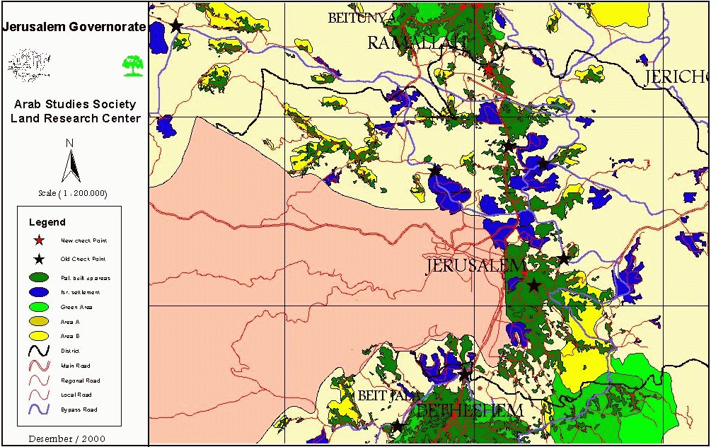
Successive Israeli governments have tried to besiege and isolate Jerusalem from its West Bank natural depth in order for Israel to annex and Judiaze this holy city. One method used to achieve that goal was to build a belt of Israeli settlements around the city. Such settlements include Neve Yaqob, Pisgat Ze'ev, Ma'ale Adumim, Gilo, Abu Ghunaim Mountain in addition to Giv'at Ze'ev. This colonization activity in Jerusalem has persisted in a feverish frequency ever since the signing of the Declaration of Principles (DOP) in Washington in 1993. The other method was the establishment of a number of permanent military checkpoints at the outskirts of the city to prevent the natural flow of Palestinians to and from Jerusalem and the rest of the West Bank and Gaza. These checkpoints have caused a great deal of devastation to the social, economic, medical, religious and educational facets of Palestinian life.
The isolation of Jerusalem was tightened as a result of al Aqsa Intifada which started as a direct reaction to the shameless visit of Ariel Sharon to the Noble Sanctuary on the 28th of September 2000. The Land Research Center (LRC) is trying here to shed some light on the increased strain on Palestinian movement into and out of the Holy City. This report will document both the checkpoints that were introduced back in 1991 in addition to the new ones that were initiated as a result of al Aqsa Intifada.
A: Military Checkpoints Established in 1991 and Reinforced after March 30th, 1993
-
Israeli military established a permanent military checkpoint in the northern east direction of the city since the 30th of March 1993. To be exact, the checkpoint is located on the road connecting Jerusalem – the village of Hizma – Jericho at the entrance of the Giva't Ze'ev settlement.
-
A major, permanent checkpoint was installed on the Jerusalem -Jericho – Al Tour – Al Zaeem crossroad. This checkpoint, with its cement cubes, blocks the eastern entrance of the city and isolates Al Zaeem away from Jerusalem. That is despite the fact that most of its residents carry an Israeli ID cards. The checkpoint also separates Al Zaeem from contingent areas which is under Palestinian administration as there is no road connecting Al Zaeem directly with these areas.
-
Another checkpoint was established at the southern end of the city on the road connecting between Jerusalem and both Bethlehem and Hebron in the south. Al Tantoor checkpoint, known to the Israeli army as checkpoint 300, was erected in March 1993 with the vision of turning it into Erez 2 similar to the Erez checkpoint in the Gaza Strip. Work on this project commenced in the past year but it came to a halt as a result of the current Intifada. This project calls for the confiscation of more than 3000 dunums that belongs to Bethlehem as Israeli occupation forces claim that their border stretch 300 meters behind the current checkpoint to include Bilal's Mosque (Rachel's Tomb). The project also calls for the establishment of a 650-meter-long path to be used by Palestinians in addition to parking lot with a 700-car capacity.
-
A permanent checkpoint was also established in Ras Al Amood on March 1993. It isolates villagers from the Jerusalem District as well as other districts from reaching Jerusalem's Old City.
-
Al Walajah checkpoint was established in the same time reference. It is located three kilometers west of Bethlehem on the entrance of the villages of Al Walajah and Beit Jala.
-
The Tunnel Permanent Checkpoint was established after the inauguration of the tunnel which connects between Jerusalem and Hebron. It is located 3 00 meters to the south of the tunnel which was dug up on Beit Jala lands. Those who don't carry an Israeli ID Card are prohibited from accessing Jerusalem through this checkpoint.
-
Beit Iksa checkpoint was erected to the south of the city at the Beit Iksa – Beit Hanina crossroad and in front of the main northern entrance of Ramot settlement.
-
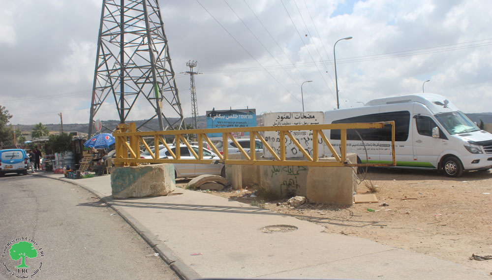
Another permanent checkpoint was established on the main road connecting between Jerusalem and Ramallah on the northern entrance of Jerusalem. This point caused the geographical discontinuity between Jerusalem, its suburbs, in addition to the cities of Ramallah and al Bireh. The point was established on the 30th of March 1993 and is still present until today.
-
Another checkpoint was established on the Jerusalem-Ramallah Road at an area commonly known as Kufr Aqab. The point is located at the entrance of Ramallah at the Kufr Aqab – Umm Al Sharayet crossroad. The Israeli army transferred the Samira Meis Hotel, located at the crossroad, into a military base from which it can block the Ramallah – Jerusalem road either completely or partially. Once blocked, alternative sandy roads are used to get to Ramallah through Umm Al Sharayet or Al Bireh. Such roads has been either blocked by cement blocks or bulldozed to make it unusable.
-
Another checkpoint was assembled in 1996 at Al Mahroofiah site, located to the south of Abu Ghunaim Mountain. This point practically separates between the villages of Al Tantour, Sur Baher, Al Khas, Al Ni'aman on the one hand and the villages of Beit Sahoor and Al Obeidiah on the other.
B: Military Checkpoints Established During Intifadat Al Aqsa:
-
A mobile checkpoint on the crossroads of Qadoom Valley -Al Mukabber- Silwan-Al Sala'a. The goal is to prevent Palestinians from the West Bank from reaching Jerusalem.
-
Sandy hill reinforced with cement blocks at the entrance of Beit Hanina. This hill effectively splits up the village into two distinct sections. One section is considered to be within the borders of ''Greater Jerusalem'' while the other section is considered to be part of the West Bank. The checkpoint was first installed in March 1993 but it was not a permanent one. It disappears and reappears according to the general political climate.
-
Another sandy hill was established on the Jerusalem-Kufr Aqab-Sath Marhaba road in the city of Al Bireh. This road was blocked after it became an alternate road to the main Jerusalem-Ramallah road which was blocked earlier.
-
Al Latron checkpoint established on the Jerusalem-Gaza road. It is located 2 kilometers away from Al Latron Cathedral and at the entrance of the Israeli army camp located there.
Prepared by
The Land Research Center
LRC