• About The Project
  • Palestine in Century
  • Selected Maps
  • Glossary
  • About ARIJ
  • About LRC
  • By Year
    • Case Studies By Year
    • Daily Report By Year
Wednesday, May 14, 2025
POICA
No Result
View All Result
  • Home
  • Settlements
    • New Israeli Settlements
    • Settlement Expansion
  • Israeli Violations
    • Agriculture
    • Confiscation
    • Demolition
    • Environment
    • Eviction of Palestinians
    • Settlers Attacks
  • Bypass Roads
  • Israeli Plans
  • Segregation
    • Checkpoints
    • Closure
    • Separation Plans
  • Military Orders
  • Reports
    • Daily Report
    • Monthly Report
    • Quarterly Report
No Result
View All Result
POICA
No Result
View All Result

Israeli Occupation Implements Separation and Military Siege on the Palestinian Territories

November 3, 2000
in Separation Plans
Israeli Occupation Implements Separation and Military Siege on the Palestinian Territories

The Israeli policy of applying separation and military blockade on the Palestinian Territories is a not a new concept. That is despite the fact that it appears as the Israeli new solution invented to face up to the recent Palestinian Uprising. 


This policy of separation and disconnecting between the Palestinian villages and cities in addition to military blockade of all the West Bank and Gaza is an old plan put forth by the Israeli army to face up to a possible Palestinian declaration of statehood. This plan is being implemented right now as the Land Research Center has observed and documented Israeli steps taken throughout the Uprising to execute such a plan. This report details the steps taken by the Israeli Army to activate the plan in the Nablus district. Other reports about other districts are to follow soon.

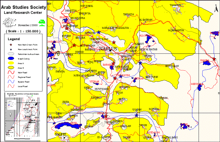
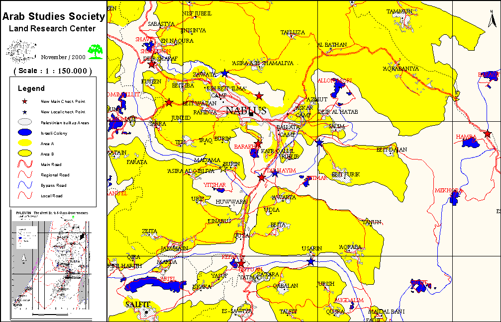
The separation plan has been implemented in the district of Nablus according to the following points:

  • Jerzeem Mountain Summit: Israel has taken step to develop the military point that was stationed there before the events of the Uprising. Now, it is the main military camp in which tanks, radar systems, military beams, in addition to heavy machineguns (500 and 800 ml) are stationed. Such machineguns have caused at least six deaths and tens of injuries in around Joseph's Tomb.

  • Ibal Mountain Summit: The Israeli military camp there has been developed to be able to accommodate the landing and departure of helicopters used to quell the Uprising. 

  • Nablus-Beit Foreek Road: The mobile military checkpoint, which used to appear occasionally at the beginning of the by-pass road, became a permanent one. Huge cement blocks were placed there in addition to the closure of three sandy roads branched off the Beit Dujnn – Beit Foreek main road. 

  • Nablus – Aorta Road: Israeli Army built a cemented check point at the old entrance of the village of Aorta in addition to a sandy one 300 meters to the west of the cement check point. 

  • Nablus – Old Beit Dujnn Road: This road is about one kilometer long. Israel used huge military D9s to demolish it. Now the road is usable neither by foot nor by car. 

  • The Southern Entrance of Nablus – Hawara Military Camp Cross Roads: At the inception of the Uprising cement blocks were installed there to separate between Hawara camp and the village of Kufr Qaleel. This cemented-checkpoint also separates between the cities of Nablus and Ramallah, as it is located on the main road connecting between them.

  • Aorta village – Rojeeb village Road: 

  • A tank military checkpoint has been installed there to prevent the movement between the two villages. The point is located about 700 meters to the east of the western entrance of the city of Nablus and its firepower has been used frequently to suppress the Uprising. 

  • Tal village – Berein village Road: This sandy road has been blocked to hider its usage as an alternative road used to get out of Nablus to Ramallah and the villages close to Nablus 

  • Za'atara Crossroad – Salfeet crossroad: 

  • These crossroads, which are located on the Ramallah-Nablus main road, has been blocked with sandbanks that are 2 meters high as to prevent the movement between Nablus and both of Ramallah and Salfeet. 

  • Nablus – Qalqilia Road: A permanent military checkpoint was installed there at the inception of the Uprising to avert the movement between the two cities. The point was installed at the Qouseen village crossroad. 

  • Nablus – Tulkarem Road: 

  • A permanent cement checkpoint has been established at the Deir Sharaf village crossroad. The checkpoint separates between Nablus, Jenin and Tulkarem, from one end and between Jenin and Tulkarem from the other. 

  • Nablus – Aseerah Road: A permanent checkpoint isolating Aseerah from Nablus.

  • The Eastern Entrance of Nablus – Jericho Road: 

  • A military checkpoint was installed there at the Al Yassidi Farm near the village of Furoosk Beit Dujnn to obstruct the movement between Jericho and Nablus. 

  • Osreen Crossroad: This checkpoint isolates and prevents the movement between the villages of Joreesh, Qisra, Aqraba, Doma, Majdal Bani Fadel. It also prevents the movement between these villages and both of Ramallah and Nablus. The checkpoint is located to the north of Za'atara crossroad in the direction of the by-pass road leading to the settlement of Ma'ale Afraeim.  


                                                                                                                                                                                                 To be Continued


Prepared by
The Land Research Center
LRC

Recommended For You

إغلاق مداخل قرية دير نظام بالتزامن مع إقامة مقطع جديد من السياج الفاصل / محافظة رام الله

by arij
June 25, 2019
0
The Israeli occupation violates human rights in Deir Nitham / Ramallah governorate

  الانتهاك: إقامة مقطع جديد من السياج الفاصل وإغلاق مداخل القرية. الموقع: قرية دير نظام شمال مدينة رام الله. تاريخ الانتهاك: 13/02/2019. الجهة المعتدية: جيش الاحتلال الإسرائيلي. الجهة...

Read moreDetails

The Israeli occupation violates human rights in Deir Nitham / Ramallah governorate

by arij
June 25, 2019
0
The Israeli occupation violates human rights in Deir Nitham / Ramallah governorate

  Violation: closing the town’s entrance and establishing a new segment of the apartheid wall. Location: Deir Nitham village north Ramallah city. Date: 13/02/2019. Perpetrator:  The Israeli occupation...

Read moreDetails

Info-graph: Manipulating the Demography of Occupied East Jerusalem
“The Construction of the Israeli Segregation Wall in and around Jerusalem

by arij
January 16, 2019
0
Info-graph: Manipulating the Demography of Occupied East Jerusalem “The Construction of the Israeli Segregation Wall in and around Jerusalem

  When Israeli captured East Jerusalem along with other Arab-Palestinian territories during the 1967 war, it became an obsession of the successive Israeli governments to win the demographic...

Read moreDetails

جيش الاحتلال الاسرائيلي ينصب بوابة حديدية جديدة شمال مدينة سلفيت

by arij
July 3, 2018
0
جيش الاحتلال الاسرائيلي ينصب بوابة حديدية جديدة شمال مدينة سلفيت

  الانتهاك: نصب بوابة حديدية على مدخل طريق زراعي شمال سلفيت. الموقع: مدينة سلفيت.. تاريخ الانتهاك: 21 حزيران 2018م. الجهة المعتديه: جيش الاحتلال الإسرائيلي. الجهة المتضرره: المزارعون في...

Read moreDetails

Israel to build new segment of the apartheid wall around “Ma’ale Isreal”

by arij
December 10, 2018
0
Israel to build new segment of the apartheid wall around “Ma’ale Isreal”

violation: completing the construction of the apartheid wall Location: Sarta Ash-Sharqiya village/ Salfit Governorate. Date:  May 01 - 2018 Perpetrators: Israeli Occupation Forces Victims:  residents of Sarta Description:...

Read moreDetails
Next Post
The Third Intermediary Report for the”Monitoring Israeli Colonizing Activities” Project

The Third Intermediary Report for the"Monitoring Israeli Colonizing Activities" Project

LATEST NEWS

Expansion of Gilo Settlement: A Strategic Plan to Isolate Bethlehem and Undermine Palestinian Rights

Expansion of Gilo Settlement: A Strategic Plan to Isolate Bethlehem and Undermine Palestinian Rights

by arij
May 12, 2025
0

........................................................

الأراضي الفلسطينية بين الذرائع الأمنية والأطماع الاستيطانية – “الأمن، الآثار، والطبيعة كحجج لاقتلاع الفلسطينيين من أراضيهم”

by arij
April 15, 2025
0

........................................................

الطرق الالتفافية الاسرائيلية وأثرها على البيئة الفلسطينية

انتهاك للطبيعة والهوية في الأراضي الفلسطينية المحتلة

by arij
March 17, 2025
0

........................................................

Israel Advances Settlement Plan on Ancient Olive Groves on lands of Beit Jala city, Violating International Law and depriving Palestinians their lands

إسرائيل تمضي قدمًا في مخطط استيطاني جديد على أراضي مدينة بيت جالا، في انتهاك للقانون الدولي وحرمان الفلسطينيين من أراضيهم

by arij
April 29, 2025
0

........................................................

flag_yellow_lowEU-PfP-Logo

This website has been produced with the assistance of the European Union. The contents of this publication are the sole responsibility of ARIJ & LRC and can in no way be taken to reflect the views of the European Union.

© 2025 Copyright ARIJ . All Rights reserved. .

No Result
View All Result
  • Home
  • Settlements
    • New Israeli Settlements
    • Settlement Expansion
  • Israeli Violations
    • Agriculture
    • Confiscation
    • Demolition
    • Environment
    • Eviction of Palestinians
    • Settlers Attacks
  • Bypass Roads
  • Israeli Plans
  • Segregation
    • Checkpoints
    • Closure
    • Separation Plans
  • Military Orders
  • Reports
    • Daily Report
    • Monthly Report
    • Quarterly Report

© 2025 Copyright ARIJ . All Rights reserved. .