The demolition of Palestinian houses by Israel has reached an unprecedented level. Between 1992 and 1995 approximately 539 Palestinian houses were demolished in the West Bank. According to the current Israeli Minister of Defense, Yitzhak Mordechi, an additional 140 houses were demolished in 1996. Moreover, since Israeli Prime Minister Netanyahu took office in May 1996, 245 Palestinian houses were demolished in the occupied Palestinian territories. Presently, the list of impending Palestinian houses slated for demolition exceeds 3,400.
Regrettably, geographical Palestine has witnessed the demolition of Palestinian homes by Israel throughout the past 49 years. By the end of the 1948 war, more than 400 Palestinian villages had been depopulated and their houses either blown up or bulldozed. Furthermore, between 1948 and 1958, a series of laws and legal instruments were created by the state of Israel to, among other things, refuse authorization of zoning plans for Palestinian villages inside the ‘green line’. Through this legal devise, hundreds of Palestinian homes have been declared illegal, targeted for demolition and demolished.
Since the 1967 Israeli occupation, destruction of a similar purpose has taken place in the West Bank. Usually, house demolitions are justified by Israel with one of three reasons: security violation, zoning violation, or the lack of a proper building license. Currently, and in violation of international law, the demolition of West Bank Palestinian homes has reached a crisis level. This is due not only to the prolonged effects of house demolitions to communities and the family unit, but also because never before have demolitions made way for such extensive environmental degradation and unilateral political implications. Ironically, this latest wave of demolitions has been escalated in the name of peace.
In response, the Applied Research Institute of Jerusalem has launched an initiative to map Palestinian houses which have either been demolished or notified of impending demolition in the West Bank and East Jerusalem. After having mapped a partial number of the houses targeted for demolition, it is apparent that house demolitions in the West Bank follow several trends, including:
1. Stopping the natural growth of Palestinian built-up areas in West Bank towns and villages.
Many of the houses slated for demolition lay on the outskirts of Palestinian built-up areas, thus extending the size of these villages and towns. Although new construction takes place upon village lands and is greatly needed to relieve crowded conditions, Israel usually denies building permits to Palestinians in these areas.
The expansion of Shua’fat refugee camp in Jerusalem is an example of this trend. The red circles in Figure 1 highlight the houses that have either been demolished or have been notified of impending demolition. They lie on the outskirts of Shua’fat Refugee Camp in East Jerusalem. highlight the houses that have either been demolished or have been notified of impending demolition. They lie on the outskirts of Shua’fat Refugee Camp in East Jerusalem.
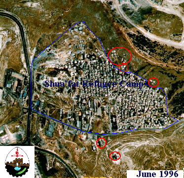
Figure 1: Houses demolished or slated for demolition in the Shua’fat refugee camp in East Jerusalem
2. Clearing ground in preparation for the establishment of new colonies and the expansion of existing colonies.
A crucial, yet often overlooked fact, is that the geographical distribution of Israeli colonies in the Palestinian territories severely restricts the growth of Palestinian communities. In most cases, colonies either surround Palestinian communities and, therefore, prevent their natural growth, or they confiscate huge tracts of Palestinian land, ensuring that the land is available for future colony expansion. Many Palestinian houses located in the vicinity of these colonies have either been demolished or are slated for demolition. A clear example of this trend is the eviction of the Jahalin Bedouin and the destruction of their encampment to clear the land for the expansion of Ma’ale Adumim colony (Figure 2).).
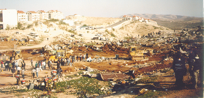
Figure 2: The eviction of Jahalin Bedouins to allow the expansion of Ma’ale Adumim colony
3. Reserving West Bank land for colony infrastructure, such as roads, industries, and recreational centers.
Lateral or ‘by-pass’ roads connect colonies and enjoy a safety buffer of 50 to 100 meters on each side where no Palestinian activity can take place, such as building houses or opening factories. Moreover, existing Palestinian houses located in areas close to planned by-pass roads are being demolished. By-pass roads encircle every major Palestinian city and community in the West Bank (Figures 3a and and 3b), and therefore create boundaries which limit the expansion and development of the Palestinian communities which they encircle, and further disconnect Palestinian communities from each other. Land currently available to Palestinians is insufficient to accommodate natural population growth, absorb Palestinian returnees, sustain the Palestinian agricultural sector and develop a strong economic infrastructure.

Figure 3a: By-Pass Roads in the Northern Part of the West Bank
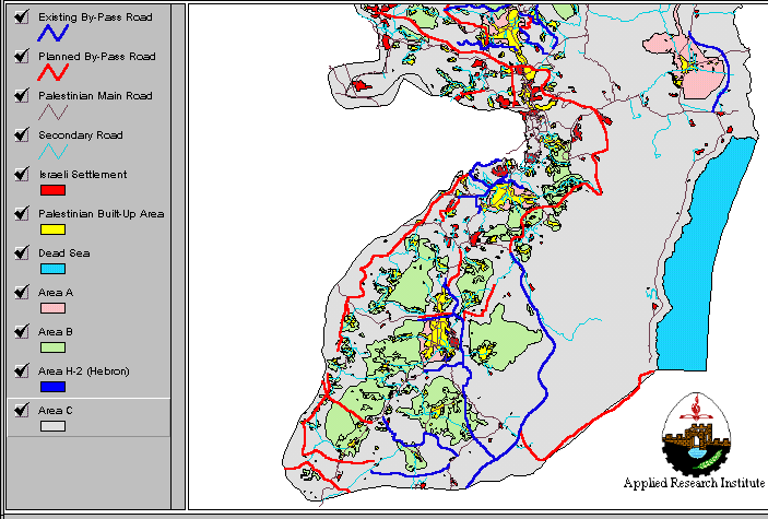
Figure 3b: By-Pass Roads in the Southern Part of the West Bank
It is worth mentioning that the by-pass roads so far built in the West Bank exceed 276 kilometers in length while the planned roads are estimated at an additional 452 kilometers. With the safety buffer zone they enjoy, the construction of these by-pass roads requires the confiscation and destruction of approximately 10,920 hectares of Palestinian land, most of which is agricultural. Many farmlands have been totally destroyed by the construction of by-pass roads, depriving owners of their main source of income. Other farmlands were split into several pieces, rendering it impossible to cross from one side of the land to another.
4. Reserving West Bank land for trans-national highways or regional roads, between Israel and Jordan.
Israel has planned that most regional roads connect Israel with neighboring countries such as Egypt, and Jordan, and furthermore, that they will be built on Palestinian land, thereby saving Israel from the environmental degradation brought on by this massive construction. Houses located in areas reserved for these regional roads are being demolished. Around 38 houses are scheduled to be demolished in the Ras Al-Amoud neighborhood and Abu Dies village in East Jerusalem in order to clear land for the construction of the Jerusalem Ring Road. This Ring Road will connect the southern parts of Jerusalem with Tel Aviv, Sinai, and Egypt (Figure 4).
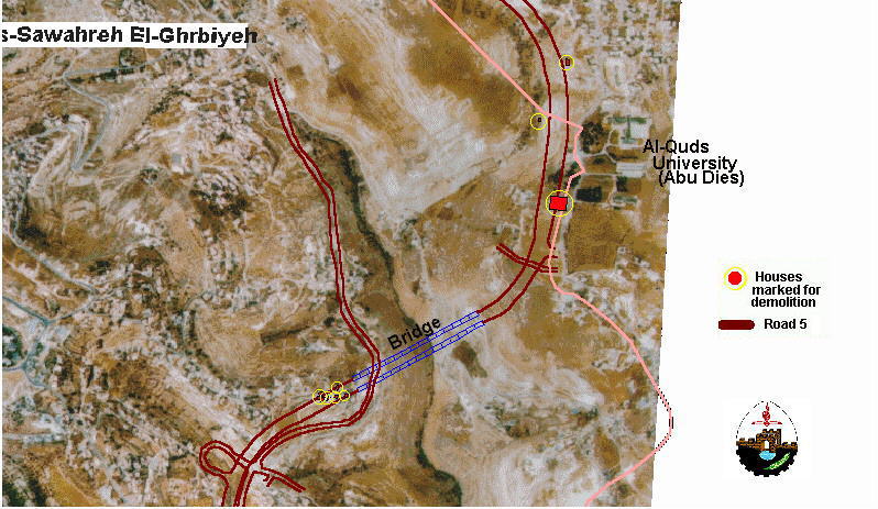
Figure 4: Houses slated for demolition, as they are located in an area designated for the construction of the Jerusalem Ring Road
5. Cleansing the Jordan Valley and the Eastern Slopes of its non-Jewish inhabitants to make way for a master plan of expansion as indicated in the Allon Plus Plan.
The Allon Plus Plan was devised by the Inner Israeli Ministerial Cabinet and was released by the Hebrew language newspaper Ha’aretz on 29 May 1997. According to this Plan, Israel will retain control over 55% of the West Bank and return to the Palestinian only 45% of their land (Figure 5). The implementation of the Allon Plus Plan will essentially render a sustainable, independent Palestinian entity impossible and force West Bank Palestinians to be completely dependent upon Israel. According to the Allon Plus Plan, the 45% of the West Bank land which will be returned to the Palestinian Authority will not only deprive Palestinians of most of their agricultural and natural grazing lands, but it will further fragment Palestine into 9 disconnected entities. It will also deprive Palestinians of the Eastern Slopes and the fertile and water-rich Jordan Valley and border areas. The implementation of the Allon Plus Plan will essentially render a sustainable, independent Palestinian entity impossible and force West Bank Palestinians to be completely dependent upon Israel. According to the Allon Plus Plan, the 45% of the West Bank land which will be returned to the Palestinian Authority will not only deprive Palestinians of most of their agricultural and natural grazing lands, but it will further fragment Palestine into 9 disconnected entities. It will also deprive Palestinians of the Eastern Slopes and the fertile and water-rich Jordan Valley and border areas. The implementation of the Allon Plus Plan will essentially render a sustainable, independent Palestinian entity impossible and force West Bank Palestinians to be completely dependent upon Israel. According to the Allon Plus Plan, the 45% of the West Bank land which will be returned to the Palestinian Authority will not only deprive Palestinians of most of their agricultural and natural grazing lands, but it will further fragment Palestine into 9 disconnected entities. It will also deprive Palestinians of the Eastern Slopes and the fertile and water-rich Jordan Valley and border areas.
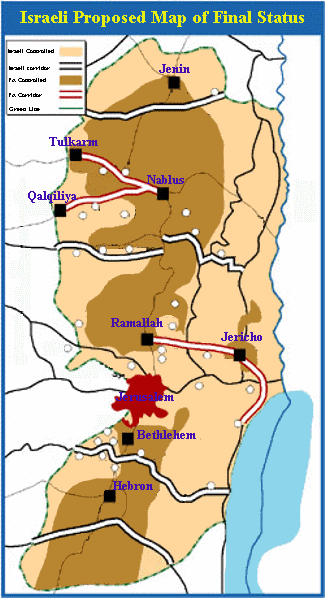
The implementation of this Plan requires the eviction and demolition of thousands of Palestinian houses in the West Bank in order to empty the land of its native inhabitants. The Allon Plus Plan will have a detrimental impact on the sustainable development of the Palestinian economic sector and, most importantly, render the aspiration of a Palestinian state unattainable.
6. Altering the ‘Green Line’, so that West Bank lands close to the border and with a small Palestinian population can be easily annexed to Israel.
It has become Israeli policy to deny building permits to Palestinians if their land lies within Area C and especially if it is close to the borders of the West Bank. For example, Israel has recently evicted many Bedouins who resided in Area C — mainly in the eastern and southern parts of the West Bank. These Palestinian-owned areas have largely been kept vacant of houses during the last decade through an Israeli imposed freeze on any Palestinian building activity. This has been accomplished by designating these areas as closed military zones, nature reserves, and state land. However, Palestinian Bedouins are the major inhabitants of the areas adjacent to these closed lands which still lie in Area C and, therefore, remain under threat of eviction and house demolition.
The campaign against Bedouins has intensified in recent years. The Jahalin Bedouins near Ma’ale Adumim were one of the first to be evicted. Tens of housing structures for the Rashaydeh and Ka’abneh tribes, located at the edge of the Eastern Slopes, were demolished and moreover their major grazing areas have been designated by Israel as closed military zones. More than 13 families of the Froush Beit Dajan Bedouins in the upper part of the Jordan Valley, were recently evicted and more than 500 people remain under threat. Also, the Ramadin Bedouins, in the far southern part of the West Bank have recently received eviction notices (Figure 6).
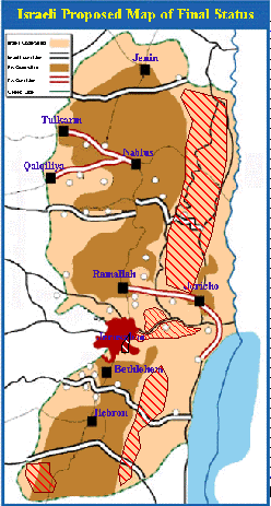
Figure 6: Location of the Threatened Bedouin Tribes in the West Bank
These measures aim at emptying Area C, especially areas near the West Bank border,of their Palestinian residents in order to facilitate their annexation to Israel, an action which is in direct violation of international agreements and the standing Israeli-Palestinian Agreement (Oslo II).
Only a partial list of Palestinian homeowners who have been notified of impending demolition or whose homes have already been demolished is presently available. This is primarily because:
1. Not all homeowners report to Palestinian officials or monitoring organizations that they have received notification of an impending demolition;
2. No list from relevant Israeli authorities has been made public;
3. New notifications are issued to homeowners so frequently and in such a widespread area that field workers are incapable of keeping the information list up-to-date.
For example, the partial list published by the Palestinian Ministry of Local Government, states that only 4 homes are slated for demolition in the village of Beit Umar in the Hebron District. And yet, according to the municipality of Beit Umar and field workers who interviewed homeowners, 17 houses have been notified of impending demolition. The nearby village of Bani Naim has only one house on the list, while field workers confirmed 12 houses (Figure 7).).

Figure 7: Houses Slated for Demolition in Beit Ummar, Halhoul, and Bani Naim
The case of Jerusalem provides a more drastic illustration. According to a map prepared by the Jerusalem Municipality, approximately 2,700 houses in Jerusalem are slated for demolition (Al-Quds newspaper, 29 July 1997, Issue no. 10030); only 39 houses are included on the list.
Nevertheless, the most comprehensive list currently available to the public is therefore included in this special report. It not only provides statistics but also assists in analyzing why demolitions take place in certain areas of the West Bank and how demolitions prepare the ground for further Israeli induced environmental degradation.
A Partial List of Houses Slated for Demolition in the West Bank, by District
Prepared by:
The Applied Research Institute – Jerusalem