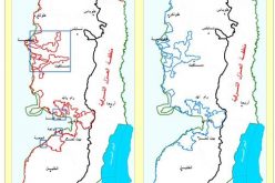
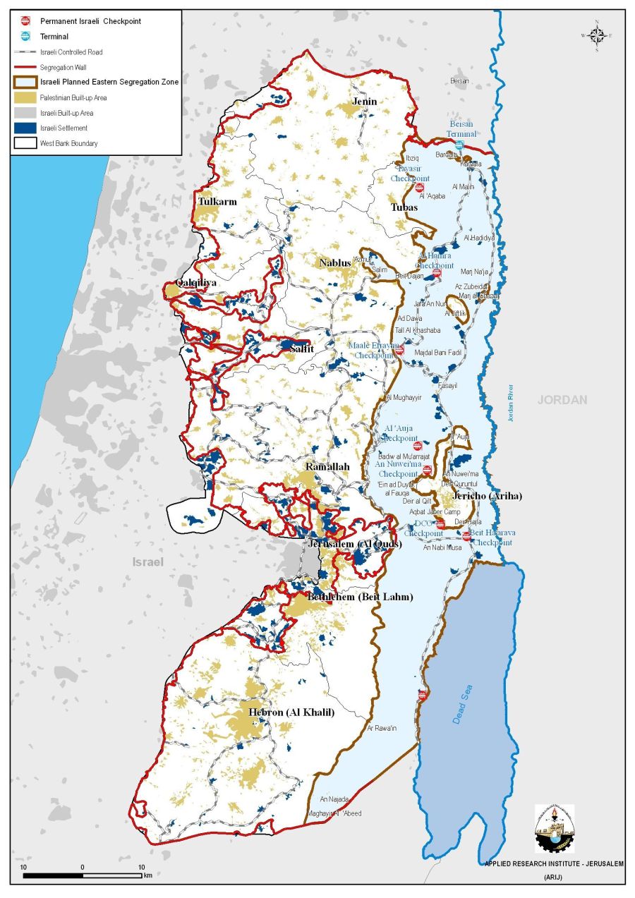
The Israeli Segregation Wall in the West Bank
On April 30, 2006, the Israeli government published another revised route of the Western Segregation plan, where the Wall will run for 703 km along the western terrains of West Bank territory. Upon Completion, the Segregation Wall will isolate west of it some 555 km�² of Palestinian land (approximately 10% of the total West Bank area) and continue to enclose 103 Israeli settlements accommodating 85% of the Israeli settler's total population in the West Bank (480000 Israeli settlers); same time, increasing the number of isolated Palestinian localities behind the Wall to 59.
At the eastern terrains of the West Bank, the Israeli government is set to maintain control over 1664 km2 (29.4% of the West Bank) stretching along the Jordan valley and the western shores of the Dead Sea. In total, the Segregation Plan appropriates at least 39% of the West Bank area. Table 1 below shows the status of the Segregation Wall in the West Bank. See Map 1
Isolated lands west of the Segregation Wall
Israel's Segregation Wall runs along the 1949 Armistice Line (Green Line) for a quarter of its length (128 km (18.2 % of the total length)). The construction of the Wall also isolates some of the most fertile areas available to Palestinians. The loss of these resources has deepened the humanitarian crisis within the Palestinian population who are highly dependent on agriculture and grazing as a source of livelihood. The isolated agricultural lands amount to 2077 km2 (2076645 Dunums), 73.6% of the total agricultural land area in the West Bank which is 2822.8 km2 (2822821 dunums). Table 1 below details the classification of the isolated agricultural lands in West Bank Governorates.
Table 1: Classification of Isolated Agricultural lands in West Bank Governorates
(Area calculated in km2 )
|
Type |
Arable |
Heterogeneous agriculture |
Permanent crops |
Plastic Houses |
Pastures |
Total |
|
Bethlehem |
23.64 |
7.74 |
18.55 |
0.01 |
0.00 |
49.94 |
|
Tubas |
99.27 |
1.86 |
70.37 |
0.28 |
0.00 |
171.78 |
|
Tulkarm |
27.60 |
4.92 |
111.01 |
2.29 |
0.00 |
145.83 |
|
Salfit |
7.73 |
0.77 |
87.90 |
0.03 |
0.00 |
96.43 |
|
Ramallah |
127.51 |
45.43 |
178.97 |
0.01 |
0.00 |
351.92 |
|
Qalqiliya |
25.92 |
1.72 |
79.33 |
2.15 |
3.32 |
112.44 |
|
Nablus |
109.23 |
35.91 |
164.03 |
0.04 |
0.00 |
309.20 |
|
Jerusalem |
36.71 |
5.72 |
12.27 |
0.00 |
3.78 |
58.47 |
|
Jericho |
73.63 |
1.50 |
25.38 |
0.78 |
0.00 |
101.29 |
|
Jenin |
184.26 |
26.84 |
121.42 |
1.70 |
0.00 |
334.21 |
|
Hebron |
229.83 |
23.33 |
91.80 |
0.15 |
0.00 |
345.11 |
|
Total |
945.32 |
155.75 |
961.03 |
7.44 |
7.10 |
2076.64 |
Source: ARIJ-GIS Database 2006
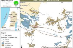
Isolated water resources in the West Bank
The Segregation Wall will and has come on areas containing artesian wells and main water basins that provide the West Bank with water, which is considered vital to sustain agricultural life going in the Palestinian society. According to April 30, 2006, (32) springs and (29) wells will be isolated in the western segregation zone in addition to (30) springs and (105) wells isolated in the eastern segregation zone. See Map 2, Table 2 & Table 3

Table 2 & Graph 1: Isolated water resources (Wells & Springs) in the Western Segregation zone.
|
Springs |
Wells |
|
|
Salfit |
3 |
2 |
|
Ramallah |
1 |
2 |
|
Jerusalem |
6 |
1 |
|
Bethlehem |
19 |
1 |
|
Hebron |
1 |
0 |
|
Jenin |
2 |
0 |
|
Tulkarm |
0 |
2 |
|
Qalqiliya |
0 |
21 |
|
Total |
32 |
29 |
Source: ARIJ-GIS Database 2006

Table 3 & Graph 2: Isolated water resources (Wells & Springs) in the Eastern Segregation Zone
|
Name of Governorate Comprising the Eastern Segregation Zone |
Springs |
Wells |
|
Ramallah |
3 |
15 |
|
Jerusalem |
2 |
0 |
|
Bethlehem |
5 |
0 |
|
Jericho |
4 |
74 |
|
Nablus |
2 |
1 |
|
Tubas |
14 |
15 |
|
Total |
30 |
105 |
Source: ARIJ-GIS Database 2006

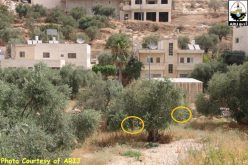
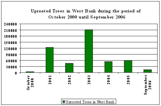
Uprooted Trees in the West Bank:
Thousands of Palestinian farmers depend on Olive trees products as a main source for their livelihood from centuries to this day as it represent some 40% of the total income of fruitful trees in the Palestinian territory.
Israeli has targeted the olive trees throughout its ongoing occupation in the West Bank as a systematic aggression to divest the lands from its Palestinian owners. Hundreds of thousands of olive trees were uprooted over the years to achieve their purposes such as; building Israeli settlements, constructing bypass roads, establishing security bases, etc, but most importantly to cut off the lively ties between the Palestinians and their lands. The olive tree has been the most to suffer the Israeli Segregation Wall plan as hundred of thousands of olive trees were uprooted since Israel started constructing the Segregation Wall in June 2002 and the security buffer zone that goes along with it. According to ARIJ database, about (515742) fruitful trees were uprooted in the West Bank since the beginning of the second Intifada until September 2006. Table 4 below shows the number of uprooted trees in the West Bank since the eruption of the second Intifada until September 2006.
Table 4 & Graph 3: Uprooted Trees during the period of 2000 and September 2006. : Uprooted Trees during the period of 2000 and September 2006.
|
Year |
Uprooted Trees in West Bank |
|
Oct-00 |
5114 |
|
2001 |
123915 |
|
2002 |
45548 |
|
2003 |
210540 |
|
2004 |
54408 |
|
2005 |
60589 |
|
Sep-06 |
15628 |
|
Total |
515742 |
Source: ARIJ Database 2006
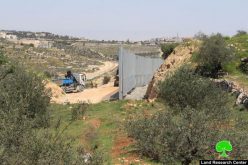
The effect of the Segregation Wall on the Palestinian Agricultural lands:
The construction of the Segregation Wall has caused to isolate much of the Palestinians agricultural lands behind it. The Segregation Wall caused many disturbances to the Palestinian farmersâ?? way of life and prevented the majority of them the right to access their agricultural lands. beside losing the right to freely access their agricultural lands, many of the farmersâ?? lands were damaged or confiscated, moreover the Israeli settlers led and still do to this day lead systematic attacks on the Palestinian farmers during harvests seasons, particularly during the olive harvest season, all of which is done under the Israeli Armyâ??s sight and most of the time with their cooperation.
In addition ,the Segregation Wall reflected negatively on the agricultural sector in the West Bank ,in fact about ( 7.44) km2 of Plastic Houses (Green Houses) isolated behind the wall with limited access to the owners, causing financial losses to an already strapped Palestinian agriculture sector which will lead to new humanitarian crises in the West Bank.
Access Denied:
Palestinian can only reach their isolated lands behind the Segregation Wall by being able to obtain special permits issued by the Israeli civil administration. These permits are issued for Palestinians who are able to prove ownership of the lands according to Israeli set categories. These permits are usually issued during harvest seasons and to certain number of hours and to a certain number of people. However, the Palestinians who lack permits are denied from accessing their lands and may lose the main income for their families.
Economical Effects:
The Segregation Wall has also isolated many of the water resources in the West Bank. The Palestinian farmers use these springs and wells for drinking and irrigation purposes, which severely influenced the amount of drinking water available to Palestinians and their agricultural products.
Legal & International Status:
The Israeli Segregation Wall has had harsh impacts on the Palestinian society especially that it cuts off the agricultural lands from its owners, and deprives them from their living and consequently affects their economic situation and life style. The construction of the Segregation Wall is a clear violation of International law and UN resolutions:
Fourth Geneva Conventions, Article 53: Any destruction by the Occupying Power of real or personal property belonging individually or collectively to private persons, or to the State, or to other public authorities, or to social or cooperative organizations, is prohibited, except where such destruction is rendered absolutely necessary by military operations.
Targeting and uprooting Olive trees by the (Israeli Occupation Forces) in West Bank miss ia clear, and a blunt violation of International laws and regulations and stands in contradiction with the 'Paris Protocols', 'Geneva Convention',' and the trade policies of the Paris protocols of 1954 which calls for 'free access for Palestinian goods to the Israeli market and vice versa.' The curfews and the uprooting are a clear violation of this clear security.
-
In addition, the uprooting and the closures are a clear violation of Article 23 of The Hague Convention, which provides that: 'it forbidden to destroy or seize the enemy's property, 'unless such destruction or seizure be imperatively demanded by the necessities of war'.
-
Land Leveling and property destruction carried out by the Israeli Occupation Forces violate the Fourth Geneva Convention and constitute a war crime under the convention and the protocols additional to the convention.
Prepared by
The Applied Research Institute – Jerusalem
ARIJ