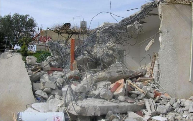
Israeli Occupation Forces staged into the village of An Nu’man village east of Beit Sahour city on Tuesday morning, the 31st of January 2006, and demolished two Palestinian houses under the slogan of being unlicensed. The forces were also accompanied by Border Police and members from the Israeli Ministry of interior who were also present at the incident of demolition.
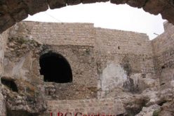
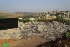
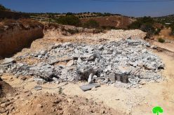
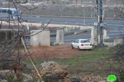
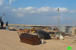
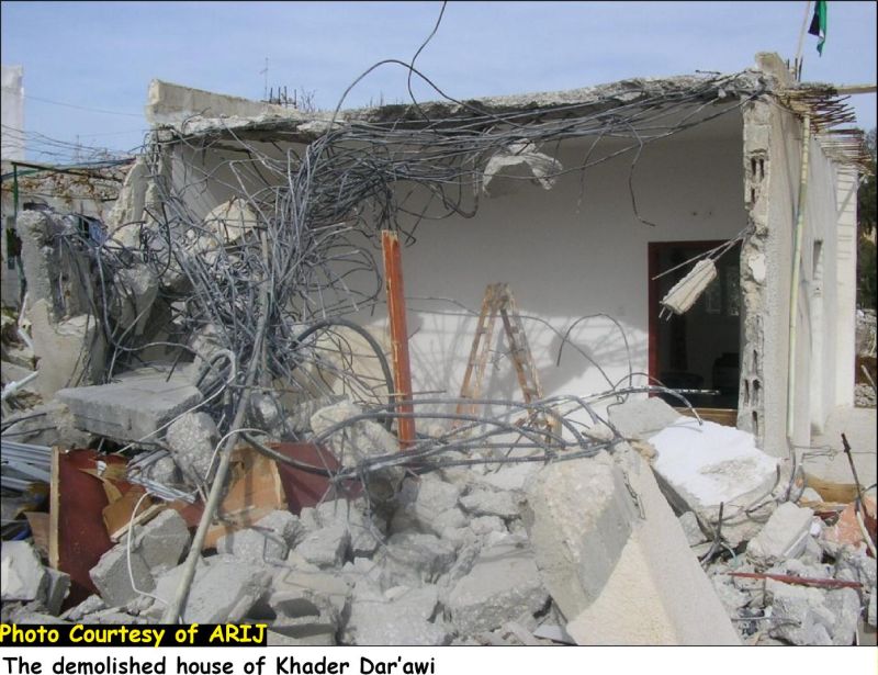
The two demolished houses are owned by the two brothers, Nidal and Khader Ahmad Dar’awi. The house of Nidal Dar’awai is 150 m² and houses 6 family members and was built in late 1999 beginning of 2000 while the house of Khader Dar’awai is 120 m² and houses 4 family members. Both families weren’t allowed to salvage any of their properties before the demolition took place and were left homeless in the cold weather. See Photo 1 & Photo 2

 s
s
ARIJ fieldworkers interviewed Mr Nidal Dar’awai, the owner of the demolished house who gave the following statement: 'I started building the house in late 1999 and continued the building process during year 2000. My house consists of two floors, the one I was living in and a ground floor which I used as a store. Constructions in the house were completed in mid 2000 and I then moved along with my wife and four children to live in it. Few months after I moved to the house, I received a military warning from the Jerusalem Municipality Court to demolish the house for building it without a license. The reason that I built without a license is due to the critical condition my village suffers ever since the occupation of the West Bank and the Gaza Strip in 1967.'
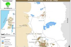
The status of An Nu’man village
The village of An Nu'man existed since the first quarter of the current century, when a number of Palestinian families started to settle in caves and barracks in the area. The topographic relief is semi-mountainous and reaches up to 720 meters above the sea level. It is bordered by Um Tuba and Sur Baher from the north, Al Khas and Um Al Qassis villages from the east, Dar Salah from the southeast, Beit Sahour from the southwest and the settlement of Har Homa (Abu Ghneim) from the northwest. There are 192 inhabitants living in the village according to the PCBS population projections of 2005. Residents of the village made a living from cultivating their lands with various field crops and grazing their sheep in the surrounding open spaces. The village continued to develop and grow throughout the years. Soon after the 1967 war and the Israeli illegal expansion to east Jerusalem municipal boundaries, the Israeli government conducted a census in the areas it occupied. Palestinians living inside Jerusalem were given a permanent residency status and were given different identification cards than those given to Palestinians residing in the West Bank and Gaza. The Village of An Nu'man was included within Jerusalem Municipal boundaries but its residence were not given the permanent residency status Palestinians living in Jerusalem were granted. Ever since the Israeli closure policy that began in the early 1990s the villagers of An Nu'man were considered as illegal residentson their lands and were not allowed to access services in Jerusalem or even schools in the nearby neighborhoods of Sur Baher or Um Tuba unless they have special permits from the Israeli civil administration.
Mr. Nidal Dar'awi continued: 'after I received the demolition warning, I sought to solve the problem and appealed to the Municipality court to prevent the demolition from taking place. The first court session was delayed for 7 times until it was finally scheduled on January 2001. It was the beginning of the second Intifada and the Israeli forces have been imposing closure on all West Bank Governorates and on roads leading to Jerusalem. I couldn't attend the first court session and had apologized through my lawyer to the court informing them of my inability of reaching Jerusalem due to restrictions imposed on the area and I didn't have permit that time to enable me to enter Jerusalem city.
He added: 'In the past, we used to go to Jerusalem through Um Tuba and Sur Baher villages, to the north of An Nu'man village, the roads were open and no fences existed that time in the area. Restrictions were less and everyone could reach the city of Jerusalem without the need to issue a permit from the DCO (District Coordination Office).
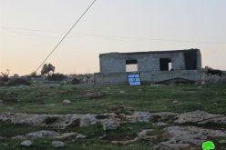
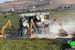
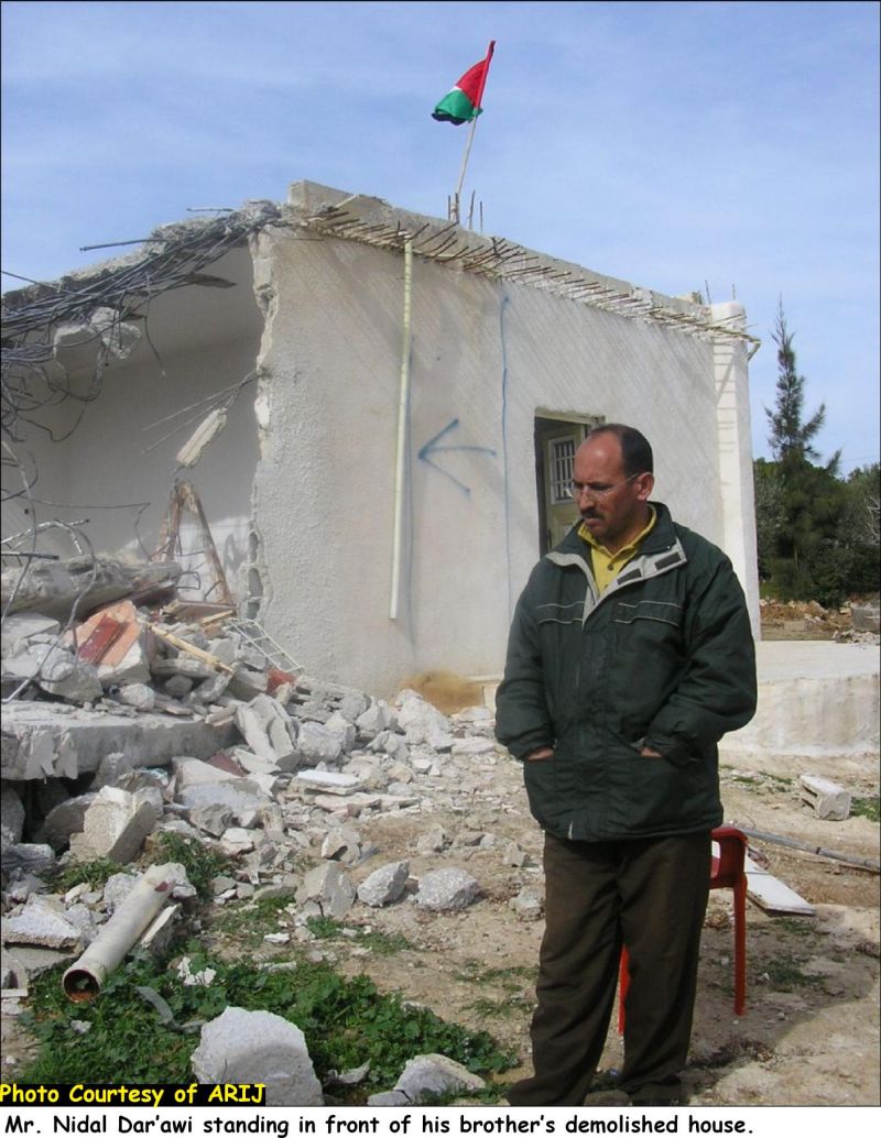
Few days later, the police arrested me for not attending the first court session although I sent a written apology to the court with the reason of my inability to attend it. I was kept in Al Mukabbir prison for the whole day and was only out of the prison with a penalty of 3500 and on one condition that I must attend the next court session which was scheduled the next month, February 2001. I attended the second court session and the court had charged me with a penalty of 57,000 NIS ($ US 12,666) to be paid 500 NIS each month. The Court also handed me a warning which include a penalty of 65,000 NIS ($ US 14,444) if I add another room to the house or refrain from paying the penalty installment on time; in addition to six-months period in jail. The Court also gave me a period of six months to start working on issuing a license for the house. I started paying the penalty on July 2001 and so far has completed the 55 installments, a total of 27,500 NIS ($ US 6,111). The last was paid on the 27th of January 2006 and later on January 31, the Israeli demolished my house.' See Photo 3 & Photo 4

License Procedure
Due to the fact that villagers of An Nu’man hold West Bank ID cards and live in an area that falls within Jerusalem Municipal boundary, the procedure of issuing a license for the house is critical. People of An Nu’man lived in the village for centuries and owned the land. The redrawing of Jerusalem Municipal boundary has put the villagers and their lands in a critical condition and they are considered now, according to Jerusalem Municipality ‘illegal residents’ living on a land under the sovereignty of the Jerusalem Municipality.Repeatedly had villagers of An Nu’man tried to issue a license for their houses before they start building but with no avail. They would apply to the Municipality asking for licenses for the house and were often met with rejection due to their condition, West Bank residents living in Jerusalem area. The need for a home and a land to settle in had forced the villagers of An Numan to build their houses without licenses. The houses of Khader and Nidal are typical examples and many other houses are yet threatened to be demolished for the same reason. Nidal’s brother, Khader, has undergone the same procedure by the Jerusalem Municipality Court and for the same reason and had also his house demolished by the Israeli Forces on the same day.
An Nu’man village lands segregated by the Israeli Segregation Wall
In the year 2003, the Israeli Government announced the construction of the Segregation Wall in An Nu'man village. Ever since that time, the village has been subjected to various Israeli practices that aimed at cutting off the residents from their lands and neighboring villages and depriving them of their right to decent life.
Constructions in the Wall have been accelerated since that time and the Wall has been erected alongside the southern and eastern parts of the village, obstructing the movement of its residents (in and out) and cutting it off from the nearby village of Al Khas and the center of services in Beit Sahour city.
Today, an arbitrary wall line of 3.44 km long is clearly seen as one enters the village of An Nu’man and it was constructed on the expense of hundreds of Olive trees that were cultivated on the lands that witnessed Wall constructions. The Wall is in its final stages and is eating up much of the village’s lands with its wide structure.
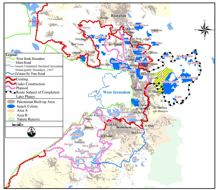
The Wall line carving An Nu'man village lands is part of the so called Jerusalem envelope Plan (The Wall around Jerusalem) which is being implemented around Jerusalem city and is expected to stretch 190 km around ‘greater Jerusalem’. See Map of Jerusalem Envelope) which is being implemented around Jerusalem city and is expected to stretch 190 km around ‘greater Jerusalem’.
Future Israeli plans entitled within the construction of the Segregation Wall
Kherbit Mazmuria (An Nu'man) Trade Passage.
On September 2005, Israel announced about new plans to be set up on lands of An Nu'man and the nearby village of Al Khas. Four Israeli military orders were handed out to residents of the two villages to confiscate lands for constructing a trade passage on lands of An Nu'man village and two other related roads, mainly for the service of the passage and another road that will lead to Har Homa Settlement. The military orders fold numbers (156-5-T (1, 2 & 3)), (154-5-T (1, 2 & 3)), (155-5-T (1, 2 & 3)) and (52-05) and state the confiscation of 43 dunums of An Nu'man and Al Khas villages for the aforementioned purposes. The Israeli forces plan to construct a trade passage along with the three roads and the military camp planned to be established once the Wall is erected, will come on 127 dunums of land all belong to Palestinians from Beit Sahour City. See map of Mazmurua Trade Passage ), (154-5-T ), (155-5-T ) and (52-05) and state the confiscation of 43 dunums of An Nu'man and Al Khas villages for the aforementioned purposes. The Israeli forces plan to construct a trade passage along with the three roads and the military camp planned to be established once the Wall is erected, will come on 127 dunums of land all belong to Palestinians from Beit Sahour City.
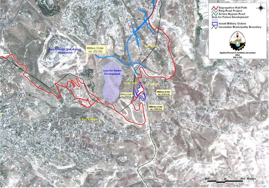
It is worth mentioning that the Israeli bulldozers were working on the site months earlier to the issuance of the military orders. The orders are complementary to the Israeli Segregation Wall plan which is being implemented on lands of the villages and confiscates 722 dunums (0.722 km²) of Beit Sahour village boundary in addition to the area that has already been confiscated following the 1967 war for rewarding the Jerusalem Municipal Boundaries.
Two new Israeli Settlements on lands of An Nu’man.
The Master Plan set by the Israeli Jerusalem Municipality (Master Plan Jerusalem 2000) indicates the presence of two new settlements in the vicinity of Har Homa settlement (est. 1997 and houses 4000 Israeli settlers) in Bethlehem Governorate, one to its southeast and another to its northwest. These two new settlements will have an approximate are of 1080 dunums (530 dunums of An Nu'man Village. The master plan also indicates that the residential area of Har Homa is planned to reach 1410 dunums that is an increase by 350% than its size today which is 400 dunums. Har Homa and the two new settlements are planned to comprise of 2500 dunums of land. See map of the Future Israeli plans on lands of An Nu'man

An Nu’man village according to the master plan is rendered invisible as all the village lands including the built up area are classified as agricultural land and are planned to remain so till 2020 while construction will be taking place few km away in favor of Israeli illegal settlement.
Conclusion
Israel’s policy of house demolitions in the Occupied Palestinian Territory seeks to confine Palestinians to small enclaves, leaving most of the land free for Israeli future plans.
Under the Fourth Geneva Convention, Israel is prohibited from destroying Palestinian property or employing collective punishment. Article 53 reads: “Any destruction by the Occupying Power of real or personal property belonging individually or collectively to private persons, or to the State, or to other public authorities, or to social or cooperative organizations, is prohibited, except where such destruction is rendered absolutely necessary by military operations.'
Prepared by
The Applied Research Institute – Jerusalem
ARIJ