The Status of Jerusalem Reconstructed
Israel’s Unilateral Actions Determine the Future of Jerusalem
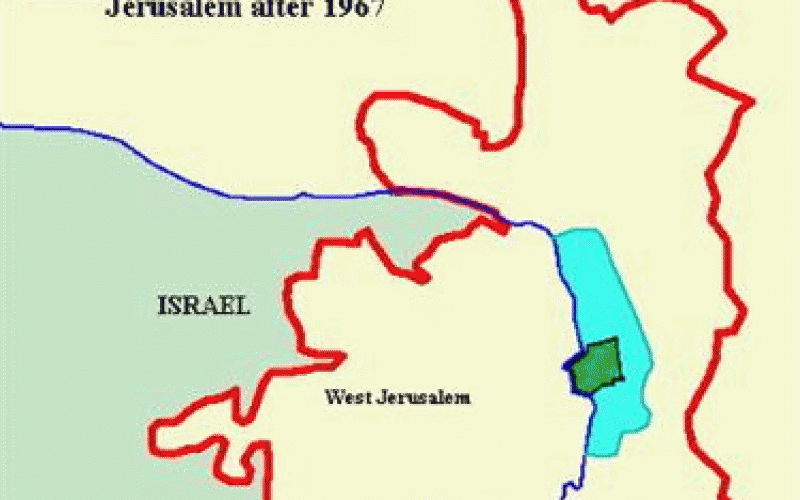
Jerusalem is the heart of the Palestinian-Israeli conflict in particular, and the Arab-Israeli conflict in general. In the current Peace Process, Jerusalem was placed as the first agenda item on the final status negotiations, which officially were started on 4 May 1996 but have not proceeded. The final status negotiations are expected to finish by 1999. However, in the meantime, the Israeli government has not stopped its unilateral practices in Jerusalem by which it creates de facto realities on the ground. These de facto realities are clearly affecting the outcome of the negotiations on the final status of Jerusalem, in Israelâ??s favor, an action that is in total violation to United Nationsâ?? resolutions, particularly 298 and 242, as well as standing Palestinian-Israeli Oslo Agreements see map below.
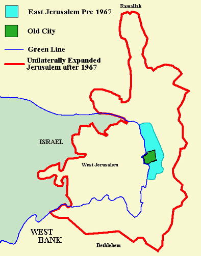
The Israeli unilateral expansion of Jerusalem borders
Measures leading to major demographic shifts have been staged by Israel in order to create an exclusive Jewish population in East Jerusalem. De-development strategies have been adopted to restrict expansion of the city's Palestinian communities. Under Israeli Jerusalem municipality, infrastructure and services for Palestinian residents, have become inadequate and do not provide a healthy living environment. Overcrowding has become the norm, and the pressure on Jerusalem's land and natural resources has been devastating as well.
Tightening the Clamp on Jerusalem
In order to tighten its control over East Jerusalem, Israel is proceeding with plans to build new Israeli colonies and expand existing ones in and around the city. The range of these colonizing activities is far greater than the unilateral Israeli declared borders of Jerusalem. Behind these activities is the Israeli intention to widen the area of Jerusalem and to envelop further lands of the West Bank into its domain. An examination of the Israeli colonizing activities in and around Jerusalem reveals the gradual application of the Israel's 'Greater Jerusalem' scheme which was formally and publicly endorsed by the Israeli Knesset on 28 May 1997 (Figure 1).

Figure 1: Greater Jerusalem According to Israeli Plans
An examination of the current Israeli activities in and around East Jerusalem reveals a systematic plan which aims at the strangulation of Palestinian communities in east Jerusalem and separation of Jerusalem from the West Bank. The intensity and multi-location of these activities shows the Israeli persistence to change the physical and demographic structure of Jerusalem before proceeding with the stalled negotiations on Jerusalem. The following pages outline individual cases of Israeli activities in East Jerusalem and their implication on the future of Jerusalem.
The Northwestern Gate
1- Expansion of Reches Shua'fat
This colony was established in 1994 on 500 acres of Palestinian private land which Israel confiscated in 1970. Israel declared this area a 'green area' and planted the land with cypress trees. Thus ,the land remained vacant of any Palestinian houses until 1994. Presently, this colony has a population of approximately 8,000 Israeli religious Jews and 2,165 housing units. Reches Shua'fat has been continually growing, expanding further on lands of the Palestinian villages Shua'fat and Beit Hanina. Israel plans to extend this colony to connect it with the colony of 'Atarout Industrial Park'.
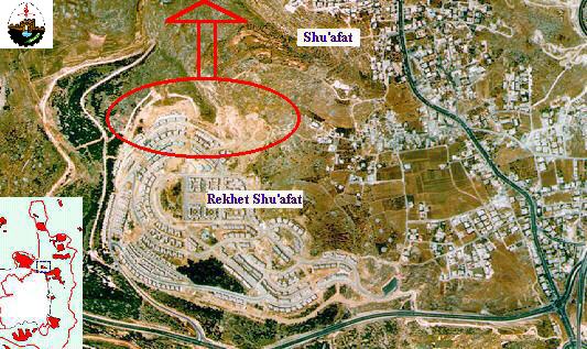
Figure 2: The expansion of Reches Shua'fat colony
2- The expansion of Ramot Allon Colony in the northwestern part of East Jerusalem
Ramot Allon was constructed in 1970. It presently houses 39,000 Israeli settlers which makes it the second largest colony in East Jerusalem after Gilo in terms of population size. The expansion of Ramot Allon is currently taking place on 50 acres of Palestinian agricultural land from the villages of Beit Iksa, Beit Hanina, and Nabi Samuel. The new expansion area is known as 'Ramot 06'. (Figure 3 and 4).
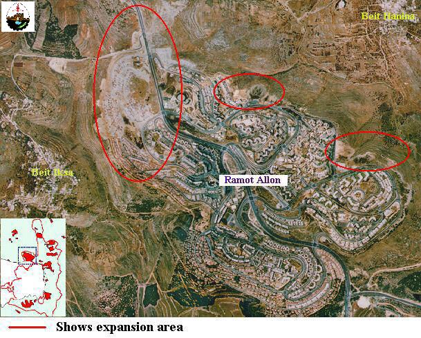
Figure 3: Aerial photo showing expansion areas of Ramot Allon Colony
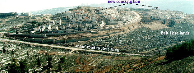
Figure 4: The northern expansion of Ramot Allon colony
3- The construction of new colony of Neve Samuel and expropriation of Nabi Samuel Park area
In 1993, Israel declared the confiscation of approximately 875 acres of land belonging to the Palestinian villages of Nabi Samuel, Beit Hanina, Jeib, and Beir Nabala. The confiscated lands were declared as a 'Public Park'. Soon after, the Israeli bulldozers started leveling land west of Nabi Samuel, preparing for the construction of new settlement of Neve Shamu'el (Figure 5). The construction work of Neve Shamu'el colony is destroying large forested area (Figure 6). This colony is the connection point between Giva't Ze'ev and Ramot Allon.
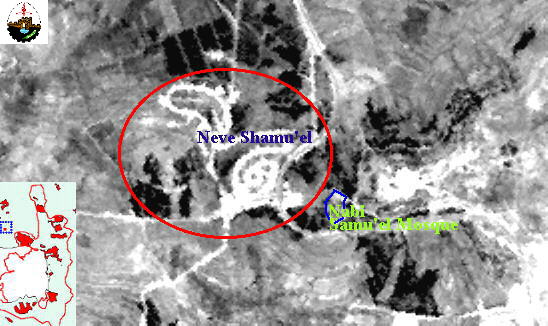
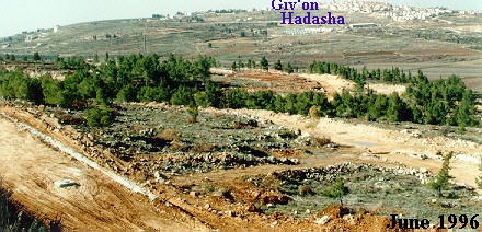
Figure 6: The infrastructure work for Neve Shamu'el and destruction of forest area
4- The Expansion of Givat Ze'ev colony
This colony was established in 1983 and presently has a population of over 8,000 secular Jews (Figure 7). Israel announced a new Master Plan for Giv'at Ze'ev increasing the colony's area to 20 square kilometers, making it one of the largest colony cities in the West Bank. The Master Plan map is shown in Figure 8.
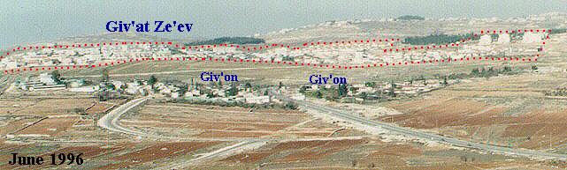
Figure 7: Photo showing Giv'at Ze'ev Colony
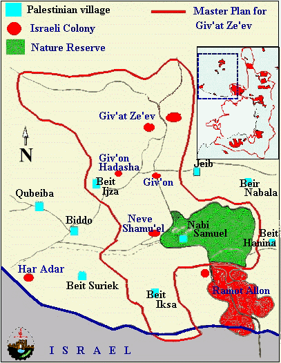
Figure 8: The Master Plan for the expansion of Giv'at Ze'ev
In this context, on 28 January 1996, the Israeli government approved a plan for the expansion of Giv'at Ze'ev (plan number 1/3/220-project 220/3), which includes the building of new 2,650 housing units in the colony and brings the number of settlers living in the colony to 20,000. The new expansion will be on lands belonging to the Palestinian villages of Betunia, Biddo and Jeib. On 13 March 1997, Israel announced another expansion plan (project 7/4/220) which lead to the confiscation of 50 acres of land from the Palestinian village of Jeib. Additional expansion plan (Project number 9/220, 1-/220 and 14/220) was released on 24 March 1997 which includes the confiscation of approximately 200 acres of land from the villages of Betunia and Jeib for the construction of 11,550 housing units.
The expansion of Giv'at Ze'ev colony aims at linking this colony with the nearby colonies of Giv'on and Giv'on Hadasha (Figures 9 and 10). It will also lead to the completion of a wall of settlements surrounding the northwestern side of East Jerusalem. Giv'at Ze'ev is planned to connect with Ramot Alon, 'Atarout, and the nascent colony of Neve Samuel. This plan will also reserve large stretches of land for the expansion of these colonies.
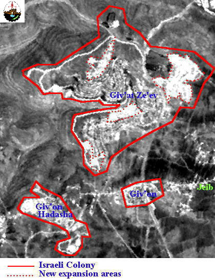
Figure 9: A satellite image showing Giv'at Ze'ev, Giv'on, and Giv'on Hadasha colonies.
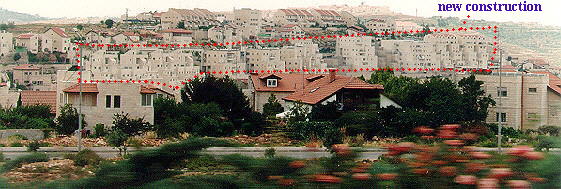
Figure 10: New construction in Giv'at Ze'ev colony
Figure 11: The colony of Giv'on Hadasha
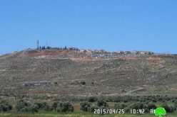
5- Expansion of Har Adar B colony
Har Adar B colony was established in 1986 and includes over 1,500 people. Israel recently announced plans to expand this colony by building an additional 800 housing units. The new expansion will be on 155 acres of lands belonging to the Palestinian villages of Biddo and Qattana (Figure 12). The expansion of this colony erases the 'green line' and unilaterally delineates the Israeli-Palestinian borders. It also deprives Palestinians of rich agricultural lands and space for their own development (Figure 13).
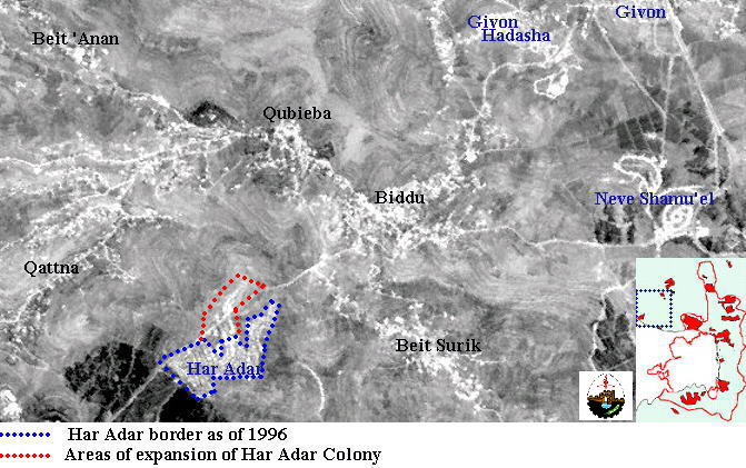
Figure 12: Satellite image showing Har Adar Colony (June 1996)

Figure 13: Ground work for the expansion of Har Adar colony
6- Expansion of the Jerusalem Airport
The Israeli Jerusalem Port Authority is preparing plans to enlarge the Jerusalem Airport. These plans include the extending of the runway by 4 kilometers and the building of storage, freight, and free trade areas. To do so, agricultural land were confiscated from the villages of Beir Nabala and Jeib.
The completion of the Israeli expansion plans of the above mentioned colonies will lead to the construction of a belt of colonies which will surround the northwestern side of East Jerusalem and the Palestinian loss of large stretches of agricultural land. The anticipated belt of colonies in this area is illustrated in Figure 14.

Figure 14: Satellite image showing the belt of colonies in the northwestern gate of Jerusalem .
The Eastern Gate
1- Neve Ya'acov
This colony was established in 1970 on originally an area of 438 acres of lands belonging to the Palestinian villages ofBeit Hanina, Hizma and Jaba' in the northeastern part of East Jerusalem (Figure 15). The present population of Neve Ya'acov exceeds 18,000 people. The plans for the expansion of Neve Ya'acov include expansion of built up area further eastwards to connect with Adam, confiscating further land from the three Palestinian villages (Figures 16 and 17).
Figure 15: The colony of Neve Ya'acov in the northeastern part of Jerusalem
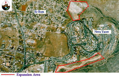
Figure 16: The expansion of Neve Ya'acov Colony

Figure 17: Areas threatened by the expansion of Neve Ya'acov to connect with Adam colony
2- Expansion of Pisgat Ze'ev and Pisgat Omer
Both colonies were established in 1985 on over 1,100 acres of lands belonging to the Palestinian villages of Shua'fat and Beit Hanina. They are currently growing in all directions (Figures 18 and 19).
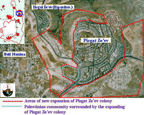
Figure 18: The expansion of Pisgat Ze'ev Colony
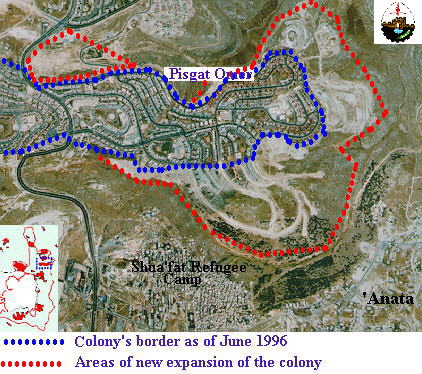
Figure 19: The expansion of Pisgat Omer Colony
The Israeli plan is to connect Pisgat Ze'ev with Neve Ya'acov and with Pisgat Omer, forming a large settlement bloc and a wall of colonies which delineate the northeastern border of East Jerusalem. Further expansion of these colonies is occurring eastwards on the land of Hizma, 'Anata and southwards on the land of Shua'fat Refugee camp (Figure 20, 21 and 22).
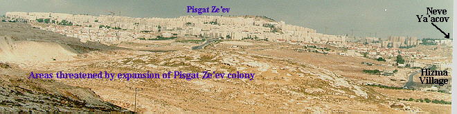
Figure 20: Area of expansion of Pisgat Ze'ev colony
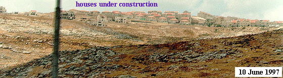
Figure 21: New construction at Pisgat Omer colony

Figure 22: the growth of Pisgat Ze'ev towards Shua'fat Refugee Camp and 'Anata village
Pisgat Ze'ev is also growing towards the West on lands belonging to Beit Hanina village. This expansion is circling a group of Palestinian house (Figure 23). The present population of Pisgat Ze'ev and Pisgat Omer in approximately 29,000 people

Figure 23: The Circling of a Palestinian community by the expansion of Pisgat Ze'ev
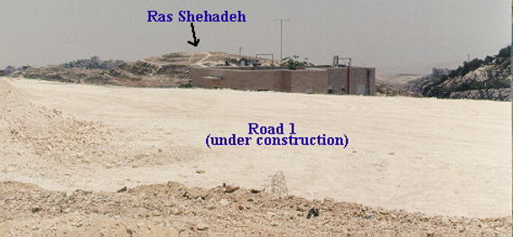
3- The Eastern Gate Colony
Groundwork is presently ongoing for the preparation of the Eastern Gate colony. This colony will be built on lands belonging to Shua'fat village and specifically on the two hill of Ras Shehadeh and Ras Khamis which are adjacent to Shua'fat refugee camp (Figure 24).
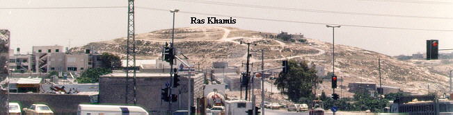
Figure 24: The hill of Ras Khamis
The Eastern Gate will create a link between the French Hill colony in the South with Pisgat Omer in the north, thus continuing the southerly extension of the wall of colonies which starts at Neve Ya'acov. Therefore, Eastern Gate Colony imposes a serious and direct threat to the Shua'fat Refugee Camp whose 10,000 Palestinian residents face continued threat of expulsion by Israel. Shua'fat Refugee Camp is located on 100 acres of land which split up the chain of colonies in that area (Figure 25). This had made the removal of the camp an urgent matter for the Israeli Government and the Jerusalem Municipality in order to implement their plans to accomplish Jewish majority in East Jerusalem.
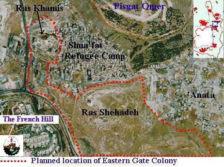
Figure 25: The location of Eastern Gate Colony
In order to maintain the land empty for the construction of Israeli colony, the Israeli Jerusalem Municipality has consistently denied Palestinians permits to build houses on Ras Khamis hill. More recently, The Israeli Municipality of Jerusalem imposed a fine of NIS 150,000 (US$ ~48,000) on a Palestinian family for building a house on Ras Khamis without obtaining a permit. The house, which is composed of two floors and provides a roof to 18 family members, is threatened for demolition by the Israeli Jerusalem Municipality (Al-Quds Newspaper, 8 June 1997).
The planning scheme of the Eastern Gate includes industrial zones, gardens, parks, and swimming pools. The Eastern Gate is planned to provide housing for approximately 2,000 Israeli Jewish settlers.
4- Expansion of 'Almon Colony
'Almon colony is a small colony which was established in January 1982 east of 'Anata village (Figure 26). The population of this colony is approximately 530 people of secular Jews. The colony blocks the road to a Latin monastery and the Ein Farah natural spring which used to supply Jerusalem with drinking water prior to 1967. Israel recently confiscated around 383 acres of 'Anata village land and designated them for the expansion of 'Almon, thus connecting it with the colonies of Neve Ya'acov and Pisgat Ze'ev, such expansion, combined with the expansion of the French Hill, Pisgat Omer and Pisgat Ze'ev, will strangle 'Anta village and eliminate any potential for expansion to absorb population growth.
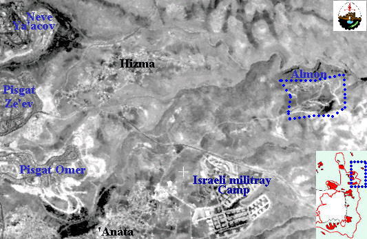
Figure 26: Satellite image showing 'Almon colony.
5- Expansion of Ma'ale Adumim Colony
which is located east of the extended boundaries of East Jerusalem, is one of the largest colonies in the West Bank (Figure 27). Ma'ale Adumim was established in 1975 and presently has a population of approximately 25,000.
Figure 27: The colony of Ma'ale Adumim
The Israeli plans for Ma'ale Adumim include engulfing around 35 square kilometers of West Bank land for its expansion. The building of new housing units around Ma'ale Adumim is going at a fast rate (Figure 28) and necessitated the eviction of the 256 members of the Jahalin Bedouin community which inhabited the Ma'ale Adumim area since 1952.
Figure 28: The southern expansion of Ma'ale Adumim colony
More recently, the Israeli Government declared the expansion of Ma'ale Adumim on over 3,110 acres of the lands from the Palestinian villages of Abu Dies, El-Ezariya, 'Isawiya, 'Anata, and Zi'em (Figure 29). This new expansion known as plan E-1, will link Ma'ale Adumim with Pisgat Ze'ev, Pisgat Omer, Neve Ya'acov and the French Hill, creating a large bloc of colonies and eliminating any Palestinian presence in that area (Figure 30). E-1 is planned to have 3,500 housing units and absorb over 50,000 Israeli settlers.
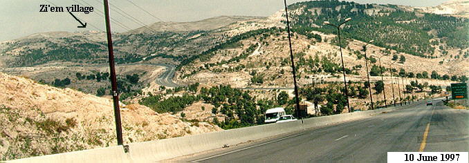
Figure 29: Forested land confiscated for the expansion of Ma'ale Adumim
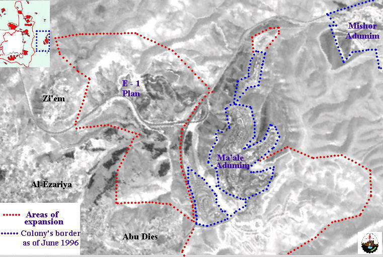
Figure 30: Satellite image showing areas of expansion of Ma'ale Adumim (June 1996).
6- The construction of the new colony of Ras Al'Amoud
The 3.5 acres of land on which Israel intends to construct the new colony of Ras Al Amoud is located in the center of the Palestinian community of Ras Al Amoud, a few kilometers east of the Old City (Figure 31). The colony is planned to contain 132 housing units and a shopping mall.
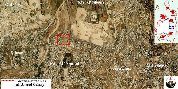
Figure 31: The location of Ras Al 'Amoud colony
The completion of the Israeli expansion plans of the above mentioned colonies will lead to the construction of a belt of colonies which will surround the eastern side of East Jerusalem and the Palestinian loss of large stretches of land needed for the sustainability of their communities. The anticipated belt of colonies in this area is illustrated in Figure 32.

Figure 32: The anticipated belt of Israeli colonies in the eastern gate of East Jerusalem
The Southern Gate
1- The Expansion of the East Talpiyot and Ramat Rachel colonies
Part of these colonies has been built on land designated by the 1949 Armistice Treaty as 'No Man's Land'. East Talpiyot colony was established in 1970 and presently has a population of approximately 15,000. Recently, the Israeli Jerusalem Municipality approved the construction of 1,300 apartments on plots of land located between Ramat Rachel and East Talpiyot (Figure 33). The new project is privately owned with an initial investment of $100 million and will include luxury apartments priced at $250,000 to over $500,000 (Figure 34). This new housing project will ensure the continuos line of Israeli built up areas between the East Talpiyot colony and West Jerusalem.

Figure 33: Aerial photo showing the location of the new housing project in East Talpiyot colony
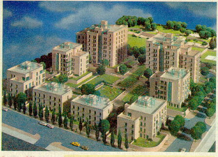
Figure 34: The planned annex to the East Talpiyot Colony
(As advertised in The Jerusalem Post Magazine, 25 April 1997)
East Talpiyot colony will also expand eastward on Jabel Al-Mukabber, where a new quarter of this colony will be constructed. The new construction will include 400 villas and 300 rooms.
2- The establishment of the new colony of Giv'at Ha Arba'
Israel plans to construct a new colony south of Ramat Rahel near St. Elijah's Church (Figure 35). This colony, which will contain 3,000 housing units, is a brick in the wall of Israeli colonies which will seal off the southern end of the extended boundaries of East Jerusalem. It will also physically separate Bethlehem from East Jerusalem.
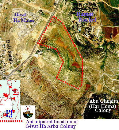
Figure 35: The proposed location of Giv'at Ha Arba'
3- Construction of Har Homa Colony on the forested mountain of Abu Ghnaim
[Abu Ghnaim forest] lies at the northern part of Bethlehem and contains approximately 60,000 pine trees. The land of Abu Ghnaim had been designated by the Israeli Jerusalem Municipality as 'Green Area' which means an area left for the preservation of landscape and the environment. Using this method, Israel was able to keep Abu Ghnaim empty of any Palestinian residential or built up area. All Palestinian application for building permits in that location were rejected. Presently, Israel is preparing infrastructure for the construction of Israeli colony on Abu Ghnaim mountain. This colony which is planned to house over 30,000 Israeli religious Jews will complete a wall of Israeli colonies in the southern part of East Jerusalem and deprive Palestinians in Bethlehem, Um Tuba, and Sur Bahir of any space for the expansion of their communities (Figure 36).

Figure 36: Aerial photo showing Abu Ghnaim (Har Homa) colony and its impact on the area
The construction of this colony is devastating the forest of Abu Ghnaim and threatening the existence of wide varieties of plants and animal species who took this forest as their oasis (Figure 37).

Figure 37: The destruction of Abu Ghnaim forest by the construction of Har Homa colony.
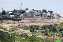
4- The expansion of the colony of Gilo
The colony of Gilo was established in 1970 on lands belonging to the town of Beit Safafa. The present population of Gilo exceeds 30,000. Within the last 12 months, Gilo colony was greatly expanded in the southern and western direction, creeping on more Beit Jala lands (Figures 38, 39 and 40).
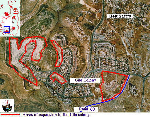
Figure 38: Aerial photo showing areas of expansion of Gilo Colony
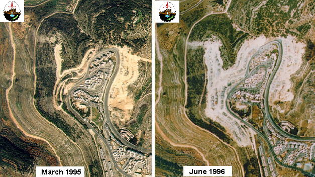
Figure 39: Two time-sequenced aerial photos showing the growth of Gilo colony with 15 months period
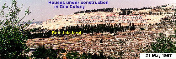
Figure 40: New construction at the western side of Gilo colony
Furthermore, the Israeli government in 1996 started building 93 housing units for Orthodox Jews on 4 acres of lands belonging to the Palestinian village of Beit Safafa. Another addition to Gilo colony is a new quarter called Mitzpa Bethlehem, which extends towards the city of Bethlehem, causing the uprooting of hundreds of olive trees which are planted in the area (Figures 41 and 42). The expansion of Gilo and the emerging Har Homa colony will ensure complete physical separation between East Jerusalem and Bethlehem area and will deprive Palestinians further agricultural land and space needed for future development and absorption of their natural growth.
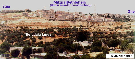
Figure 41: The Mitzpa Bethlehem colony
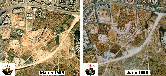
Figure 42: Two time-sequenced aerial photos showing the growth of Mitzpa Bethlehem with 15 months period
5- The establishment of Gani Bitar colony west of Gilo
Gani Bitar is a proposed colony which Israel is planning to construct west of Gilo colony on lands belonging to the Palestinian village of Al-Walaja and the Salesian monastery of Cremisan (Figure 43). No information has yet been released regarding the size of this colony.

Figure 43: Aerial photo showing the approximate location of the planned colony of Gani Bitar
6- Expansion of Giv'at HaMatos colony
The colony of Giv'at HaMatos was established in 1992 on 63 acres of land belonging to the Orthodox Church. It presently includes 280 mobile houses which were built to absorb Jews brought from Ethiopia (Figure 44). Israel plans to expand this colony to 245 acres and build an additional 3,600 housing units on an area of approximately 250 acres belonging to the Palestinian village of Beit Safafa. The expansion of Giv'at HaMatos and Gilo colonies, in addition to several new roads which Israel is constructing in the area, will strangle Beit Safafa, eliminate space for its development, and divide the village into miniature cantons. The expansion of Giv'at HaMatos will also complete the wall of colonies which surrounds Jerusalem from the south.

Figure 44: Aerial photo showing Giv'at HaMatos and proposed expansion area
The completion of the Israeli expansion plans of the above mentioned colonies will lead to the construction of a belt of colonies which will bloc the southern gate of East Jerusalem and physically separate it from Bethlehem. It will also disconnect the northern parts of the West Bank from its southern parts. The anticipated belt of colonies in this area is illustrated in Figure 45.

Figure 45: The anticipated belt of Israeli colonies in the southern gate of East Jerusalem
Roads Linking settlements
Israel is in the construction phase of many roads in East Jerusalem which will facilitate the movement of Israeli settlers between the various colonies in and around East Jerusalem, reserve large stretches of land for the expansion of Israeli colonies, and eliminate continuity and development opportunities of the Palestinian communities ion East Jerusalem (Figure 46)
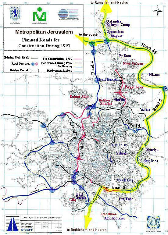
Among the planned roads, the following are major in their extent and impact on Palestinian communities:
1- Road 45 and 5
These two roads will great a ring road which will circle East Jerusalem and physically separate it from the rest of the West Bank. It will also spare large stretches of land for the sole expansion of Israeli colonies in East Jerusalem (Figure 47). Over 4,000 acres of land, mostly agricultural, have been confiscated and around 38 houses are to be demolished in` the process of building these roads.
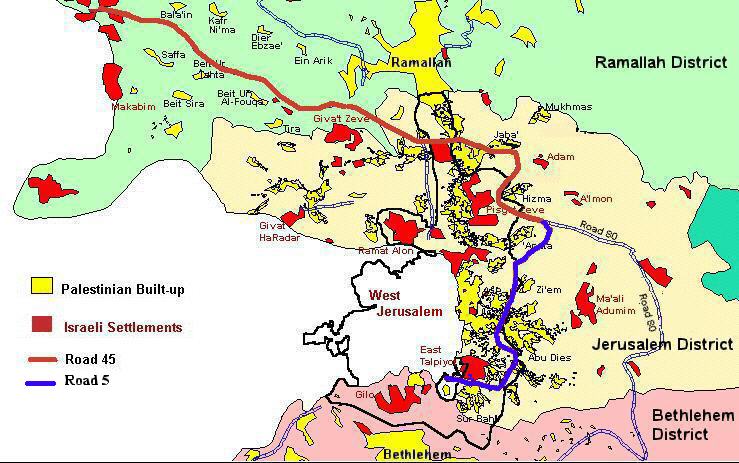
Figure 47: The Ring Road around East Jerusalem
Road 5 will connect Road 45 with Road 4 where it passes through the land of Beit Safafa, further fragmenting the village (Figure 48).

Construction work in different segments of Roads 45 and 5 has been going (Figures 49 and 50).
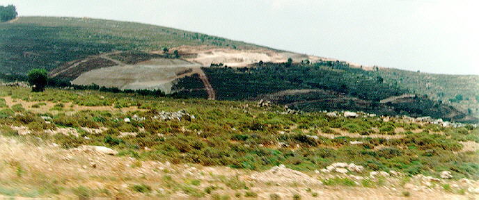
Figure 49: Construction of Road 45 near Betunia village

Figure 50: Construction of Road 45 north of Hizma village
2- Road 4
This road will connect 'Atarout and the Jerusalem airport with Reches Shua'fat and further extends south to reach Gilo colony area (Figure 46). The construction of this road leads to the destruction of many Palestinian agricultural lands and divides Beit Hanina into two disconnected communities. It further restricts the growth of the Palestinian community of Beit Hanina towards the west. Two Palestinian houses have already been demolished to facilitate the construction of this road. The segment of Road 4 which extends to Gilo passes through the lands of Beit Safafa village, fragmenting it into pieces and destroying large stretches of agricultural lands (Figure 48).
3- Road 1
The first stage of this road was constructed in 1992 which connects the Damascus Gate area with the French Hill. The second stage of this road, which is currently under construction, extends Road 1 northwards to end at the entrance of Neve Ya'acov colony.
Further construction of this road will lead to the confiscation of 95 acres of Palestinian land and the demolition of over 17 Palestinian house. This road is parallel to road 13 and the main Jerusalem Ramallah Road (Figures 51 and 52) thus there is no justification for its construction except for physically separating vacant Palestinian lands from the Palestinian towns of Beit Hanina and Shua'fat. On these vacant Palestinian lands is the area, Israel intends to build 3,815 housing units and an industrial zone.
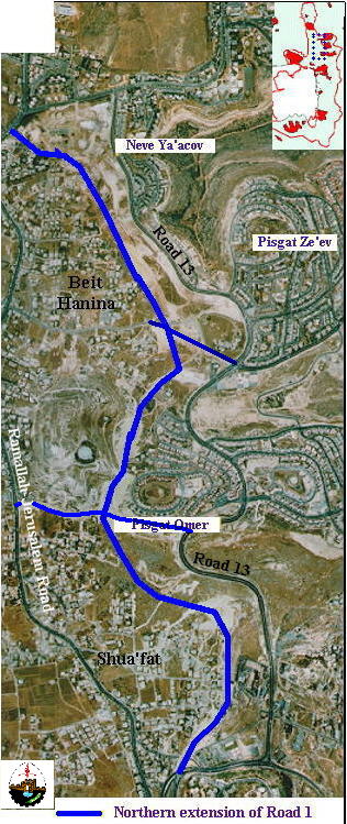
Figure 51: Aerial Photo showing the location of Road 1
E- Road 16
This is a planned road which will connect West Jerusalem and the French Hill with Ma'ale Adumim. The road will be laid on Wadi Al-Joz land in East Jerusalem and will pass under the Augusta Victoria hospital on the Mt. Of Olives through a tunnel which will emerge near Zi'em village to connect with both Roads 5 and Pisgat Ze'ev-Ma'ale Adumim Road (Figure 53).
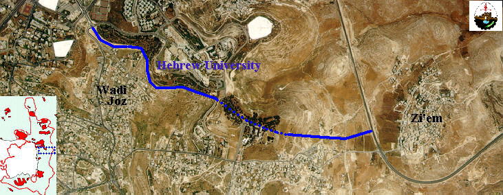
Figure 53: Aerial photo showing the location of Road 16
In sum, the Israeli construction in East Jerusalem is altering the whole demographic and physical status of the city and strangulating the existing Palestinian neighborhoods, making it impossible for them to expand or absorb the natural population growth. Such measures are complimented with various laws which allow Israel to withhold the identification cards of over 60,000 Palestinian citizens in East Jerusalem and to deny them permits to live in the city. Demolition of Palestinian houses and denying building permits in East Jerusalem are other methods which Israel utilizes to evacuate the city of its Palestinian inhabitants. The delay in the final status negotiations on a peaceful settlement of the Israeli Palestinian conflict has been deliberately staged by Israel in order to gain extra time which will allow it to create facts on the ground which will strengthen the Israeli position at the negotiation table.
The future status of Jerusalem is being unilaterally shaped now. At the current rate, the final scheme of East Jerusalem will be not much different from what is portrayed in this profile.
Prepared by:
The Applied Research Institute – Jerusalem