Az Zawiya: A model for non-violent resistance against the construction of the Segregation Wall
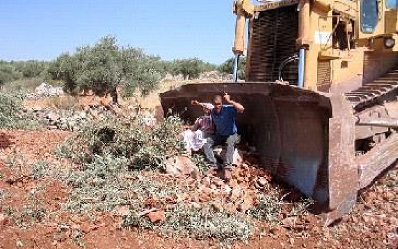
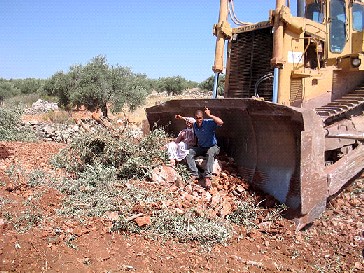
Az Zawiya- Salfit: A man and his wife sitting in front of an Israeli bulldozers working on the the construction of the Apartheid Wall
Location and population
Az Zawiya village is located 24 km to the south of Qalqiliya city and 19 km to the west of Salfit. The village's borders is affiliated to the governorate of Salfit.
The village housed a population of 1400 inhabitants before the 1967 war, a number that decreased to 1100 following the war as a result of exodus. According to the latest statistics conducted in 2002, the village housed a population of about 5300 people.
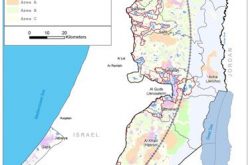
The village is formed of many extended families, including the families of Shuqeir ( 45% of population); Muqadi ( 30% of population); and Radad ( 20 % of population) while the remaining 5 % is formed of refugee families such as Shamlawi, Rabi and Yusif. See location map
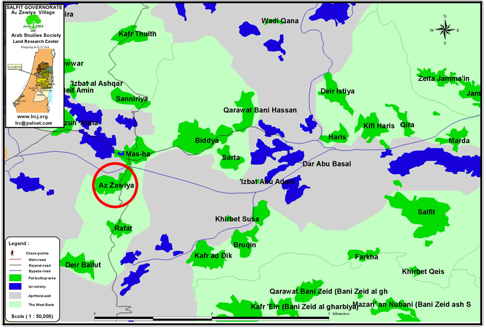
The three villages of Az Zawiya, Rafat and Deir Ballut are confined to one enclave by the Apartheid Separation Wall with only one entrance and exit under Trans Samaria highway to the north of the villages
Before 1967, about 95 % of residents depended on agriculture and animal husbandry as main source of income and 5 % on civil jobs. Between 1967 and 2002, about 80 % depended on agriculture and labor market in Israel, 10 % on commerce in the nearby Mas-ha trade market and 10 % on civil jobs. Nowadays, almost 87% of Az Zawiya labor force are jobless due to Israeli closures and restrictions on movements.
Village area and Israeli colonization
-
In 1948, the total area of Az Zawiya lands was 34000 dunums, out of which 10000 dunums were lost during the 1948 war.
-
In 1978, the Israeli colonial group 'Gush Efrayim' occupied Al Hilo mountain hilltop to the north of village and set the basis for the settlement of Elkana. As a result, 500 dunums of the village's lands were confiscated for the construction of this settlement. Thousands of dunums were also lost in successive years for colonial expansions in the area.
-
In 1999, at least 3000 dunums were lost for building Trans-Samaria colonial highway -number 5- connecting Ariel settlement with the Israeli coastal areas. In consequence, more than 30000 fruitful olive, almond and carob trees were uprooted in these most fertile areas of the village.
Currently, Az Zawiya remaining lands do not exceed 13000 dunums, according to Az Zawiya municipal council.
The new Israeli military order No. T/240/04 issued for construction the Segregation Wall gives the Israeli army full control over lands belong to the three neighboring villages of Az Zawiya, Deir Ballut and Rafat as followed:
-
Az Zawiya: plot No. 4, the areas of Baten Salim, Wadi Azmir, Wadi Ash Shami, Marj At Tabaqa and and Jabel Al Kurum;
-
Deir Ballut: Plot No. 4, the area of Ard Ad Daher and plot No. 2, the areas of Al Khalil and Khalet Al Abkar.
-
Rafat: plot No. 3, the area of Marj Qadum.
Non- stop Settlers' violence
Besides land confiscation, the Israeli settlers in Az Zawiya area carried out the following series of violent actions against local people and their private properties:
1. Preventing Palestinian farmers from tending their fields and picking olives during the last three years of the second Intifada. Farmers had to be escorted to their fields with international and Israeli solidarity groups and peace activists who protected them from Israeli attacks.
2. Burning of 25 dunums of olive trees in 2001 located near Trans-Samaria highway;
3. Burning of 200 dunums of olive trees during the month of June, 2004, located in Khalet Ar Rumeila to the west of the village. The burned trees are situated on lands designated for confiscation for the purpose of the Segregation Wall.
Az Zawiya and the Segregation Wall
The second phase of the Segregation Wall starts in Az Zawiya land and goes south to Al Samu' village at the southern edge of the West Bank. Az Zawiya village is located south of Mas-ha village, where the first phase of the Wall was finished last year. The first phase started in Zaboba village north of Jenin until the villages of Masha and Habla in Tulkarem district.
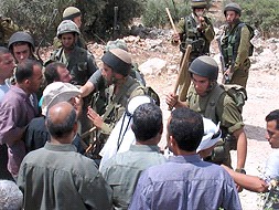
On June 6th, 2004, the Israeli bulldozers came to Az Zawiya village in an attempt to commence the construction of the Segregation Wall. Az Zawiya residents vowed to come everyday to their land to stop the Israeli constructions in the areas, along with Israeli peace activists and international solidarity groups.
Works at the second phase are underway in other places rather than Az Zawiya as the Israeli Supreme Court issued a ruling on June 25th, 2004, ordering the construction works on the Segregation Wall in Az Zawiya vilage to be halted. This is being viewed as a victory by the village of Az Zawiya as well as the Israeli activists and international solidarity movements who have been protesting non-violently against the construction of the Wall on a daily basis since June 7th, 2004.
The Israeli army's response to the non-violent demonstrations against the construction of the Wall in Az Zawiya village had involved a disproportionate use of force. There have been hundreds of injuries, mostly caused by rubber bullets and tear gas among the Palestinians, Israeli and international protesters during the non-violent demonstrations. The severity of the tear gas injuries created convulsions, severe breathing problems as well as miscarriages. This has created an international cry of concern regarding the of non-lethal chemical weapons during peaceful demonstrations.

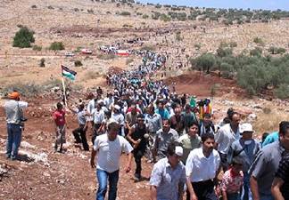
Az Zawiya- Salfit: Two contrasting pictures: to the left, a Palestinian peaceful march, to the right, Israeli soldiers firing tear gas. Photos courtesy of LRC
The planned route of the Wall will completely enclose the villages of Az Zawiya, Deir Ballut and Rafat ( see attached map). The villages will be completely cut off not only from Israel but also from their own agricultural lands, their livelihood and the rest of the West Bank. Their only entrance and exit will be a narrow road entrance under Trans-Samaria highway-number 5- located between the villages of Masha and Az Zawiya. ). The villages will be completely cut off not only from Israel but also from their own agricultural lands, their livelihood and the rest of the West Bank. Their only entrance and exit will be a narrow road entrance under Trans-Samaria highway-number 5- located between the villages of Masha and Az Zawiya.
The three villages are totally dependent on their land for economic survival. If Wall constructions proceed as planned, the three villages will have their land confiscated and be surrounded by Wall blocks. The attached map shows that there is no security basis for confiscating the land and isolating these villages in an enclave.
In an interview with Mr. Anan Ashqar, member of Az Zawiya local committee, he said: ' I hope the ruling of the Supreme Court will stop our pain. This ruling is a direct result of the efforts of the people of Az Zawiya as well as the Israeli and international activists who have supported us. The Israeli government is always trying to take our land .. we are always facing new confiscation orders of our lands. Our struggle is not over. There is continuous aggression on land in this area'.
In another interview with Mrs. Hamda Odeh, 75 years old, from Az Zawiya, she said:' I have been tending my land for almost 50 years. It was an arid land with no trees. We spent long time and huge efforts to make this land bloom with different types of trees. Look what they have done with my land. Once it has become a heaven of trees and blossomed, the occupation came in a blitz attack and destroyed every thing. Who is going to restore our usurped right and land? In this area, where the Wall is going to be built, I have four plots of land cultivated with olives and grapes, each is 40 dunum in size'.
According to Az Zawiya municipality leader, Mr. Adam Shamlawi, the route of the Wall will be built over an area totaling 300 dunums ( 50 meters width by 6 kilometers length) in the areas of Wadi Zimeer, Al Awa'ra, Khalet Zanka, Ar Rumeila, Al Masatih and Khalet At Tabaqa which form parts of plot number 4. This is excluding thousands of dunums of agricultural lands that will be separated by the Wall around the village.

Az Zawiya- Salfit: Heavy Israeli military presence in the face of unarmed civilian protesters, Photos courtesy of LRC
He added that the Israeli army confiscated 'solid waste dumping site' in that area creating an ecological crisis in the village due to the unavailability of any alternative sites.

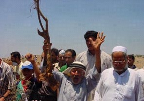
Az Zawiya- Salfit: Old men, youth and children were very active in protesting the construction of the Wall. Photos courtesy of LRC
Mr. Shamlawi went on to say that the Israeli authorities will confiscate a water-well that was dug during the Jordanian era, in addition to a number of springs which were used for domestic, agricultural and construction purposes before the current water network was provided to the village. The confiscation of these water resources will eventually deprive farmers and cattle breeders from an important natural resource.
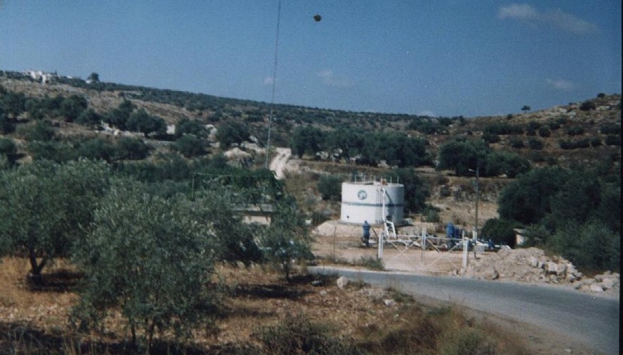
Az Zawiya- Salfit: The only well in the village land confiscated by the occupation, Photo courtesy of LRC
Prepared by
The Land Research Center
LRC