Israeli Plans
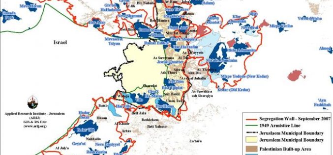
The Israeli efforts to consolidate settlers’ colonial hold over the city of Jerusalem
When the current Israeli government took office in February 2009, it spared no effort to achieve its colonial and expansionist projects in the Occupied Palestinian Territory and to tighten the
Israel Includes Two West Bank Holy Sites on Israel Heritage Sites List
After an Israeli cabinet meeting on February 21, 2010, the Israeli Prime Minister Benjamin Netanyahu announced that two holy sites located in the West Bank, the Ibrahimi Mosque in Hebron
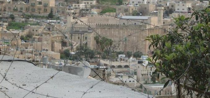
The Ibrahimi Mosque… a Jewish Cultural Site !!!
The Israeli Occupation Government, led by Benjamin Netinyahu, announced on February 21, 2010 the Ibrahimi Mosque and Bilal ibn Rabah Mosque (called Rachel Tomb) Jewish cultural sites. In addition, the
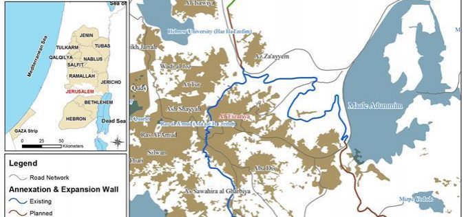
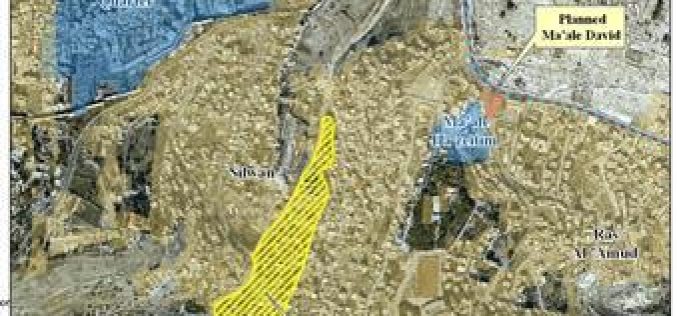
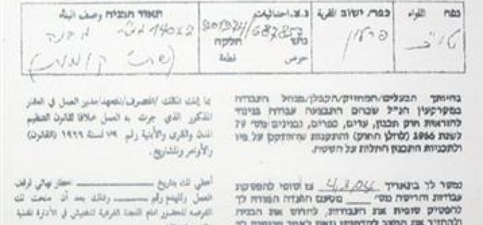
Jerusalemites Are About Losing their Identity in Al ‘Eizariya
Violation: tens of Palestinian families are about to lose their right to residency. Location: Al ‘Eizariya residential block. Date: February, 2010. Victims: residents. Violators: the Israeli Occupation National Insurance Institute.
The Israeli efforts to consolidate settlers’ colonial hold over the city of Jerusalem
Abstract When the current right-wing Israeli government took office in February, 2009, it spared no effort to achieve its colonial and expansionist projects in the Occupied Palestinian Territory and to

“Die Judaisierung Ost- Jerusalems” – Was geschieht wirklich im Viertel von Al Bustan?
Al Bustan ist ein palaestinensisches Viertel in der Mitte der Stadt Silwan, die im suedoestlichen Teil der Altstadt von Jerusalem liegt. Entsprechend der Land- und Eigentumsklassifizierung aus der britischen Mandatszeit

“The Judaization of the Eastern Part of Jerusalem City”
What is really happening in Al Bustan Neighborhood?
Al Bustan is one Palestinian Neighborhood located in the middle of Silwan city in the southeastern part of the Old City of Jerusalem. According to the British Mandate classification of
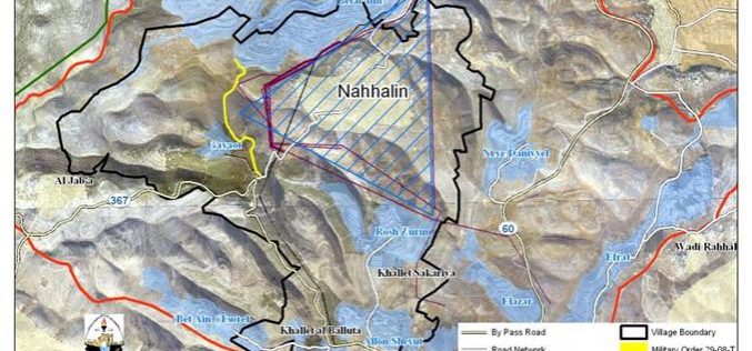
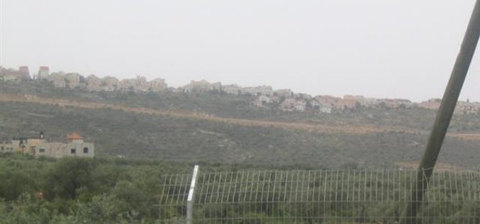
An Israeli Electricity Grid to curtail Nahhalin Village Lands
To ensure that the village of Nahhalin (southwest of Bethlehem city) not only stops growing but actually decreases in both size and population, Israel has taken many steps throughout the
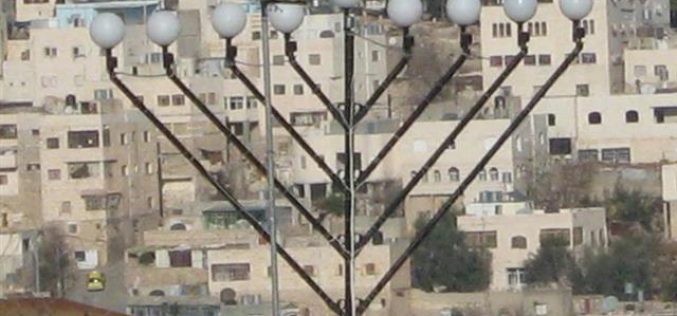
Setting up of a Jewish Hanukah at the top of at Takruri mountain in Hebron’s old city
Last December the Israeli occupation authorities set up a Jewish candlestick (Menorah – Hanukah) at the top of at Takruri mountain in the old city of Hebron. See Photo 1
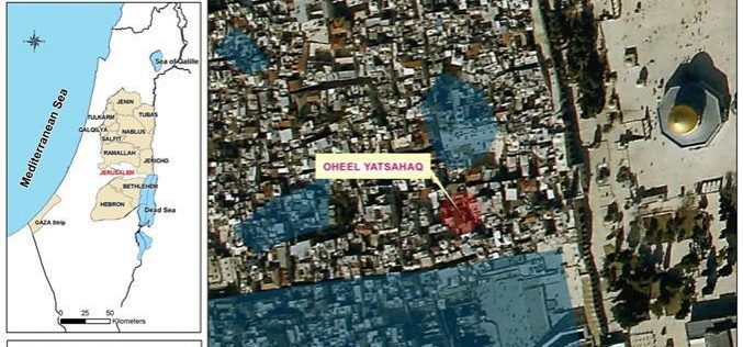
A Jewish Synagogue Near Al Aqsa Mosque
In a new violation added to the black record of the Israeli occupation, the Ateret Cohanim colonial organization has inaugurated a Jewish synagogue in the Islamic Quarter in the Old
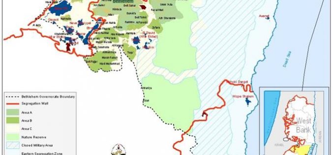
Den Geopolitiske Status i Bethlehem Governorate
Bethlehem Governorate ligger i den sydlige del af Vestbredden, syd for Jerusalem. Det har et areal paa 698 km2, og er hjemsted for naesten 200,500 Palaestinensiske indbyggere (PCBS, 2007). Det
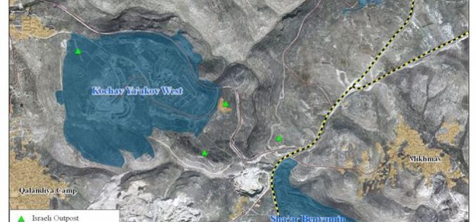
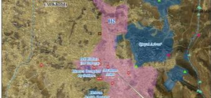
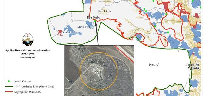
The Delusion of evacuating Migron Outpost
Introduction: Migron is an outpost established on a hilltop located 7 Km east of Ramallah city in the West Bank, 2.5Km north-east of the settlement Kochav Ya'akov. In April
Israeli Occupation Authorities Issue a Master Plan for the Village of Brokin
On the 7th of September, 2008 the so-called 'Organization and Building Committee' branch of the Israeli Civil Administration issued a Master Plan for the village of Brokin. According to the
“Planning & Conspiring… and the Palestinians are paying the price”
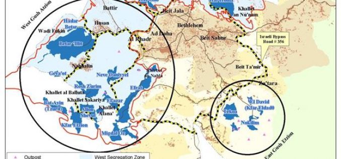
New Israeli Arrangements to expand the Administrative Control Area of Gush Etzion Settlement Bloc.
Currently, the Israeli settlers of Gush Etzion settlement bloc are working on reshaping the Israeli negotiation statement which was adopted by the Israeli political leadership according to their never-ending expansionist
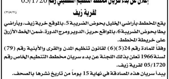
The Israeli “Civil Administration” Issues a Master Plan for Zeef Village
The so-called Israeli 'Civil Administration of Judea and Samaria' issued an order number 05/1720 concerning the village of Zeef in the town of Yatta. The Order, which was published in
Israeli Occupation Authorities Mislead the Local and International Media with the Removal of an outpost in the West Bank
On the eve of the visit of the US’s Secretary of State to the region in late March 2008, Israeli occupation authorities pledged to remove a number of colonial outposts
The Israeli Outposts’ Evacuation Bubble
According to the secret agreement singed between the Israeli ministry of defense and Yesha council; the latter will evacuate 26 outposts voluntary. In return the Israeli ministry of defense will
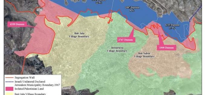
The Strangulation of Beit Jala City
Beit Jala city: Location & Population Beit Jala city is located one Kilometer west of Bethlehem city and 8 Kilometer southwest of Jerusalem at an altitude ranging between 650 –
A new Israeli master plan for Khirbet Jubara confines Palestinian construction
The Israeli Occupation Authorities recently issued a master plan for Khirbet Jubara in Tulkarem Governorate. The new master plan defines only 75 dunums of land as built-up area while the
Israeli Occupation Authorities Transform the so- called “Judea and Samaria College” in Ariel Colony into a University
The administration of the so-called College of Judea and Samaria, located in the colony of Ariel in the Governorate of Salfit, has declared its intention to upgrade the college into
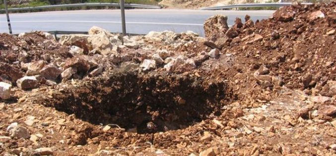
High voltage power lines devour Palestinian land in service of Israeli settlers
(Photo 1: A pit that has been dug up in Halhul land along road number 60 for the use of a high voltage power line) Last December, the
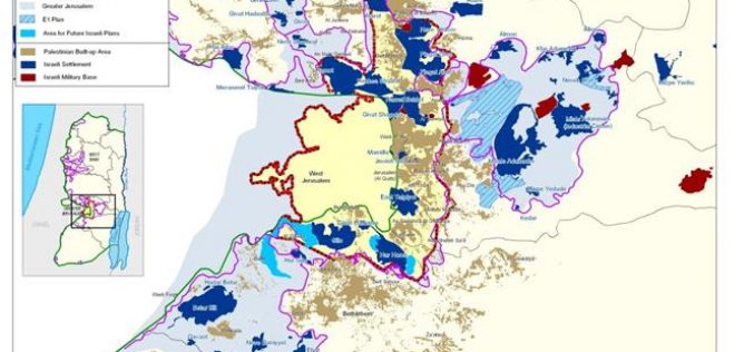
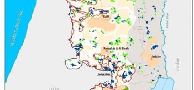
E1: a Deal Breaker to possible Palestinian – Israeli Peace
Since the outbreak of the second Intifada, in September 2000, Israel increased the level of restrictions on the movement of Palestinians occupied territory that are unprecedented in scope and time.
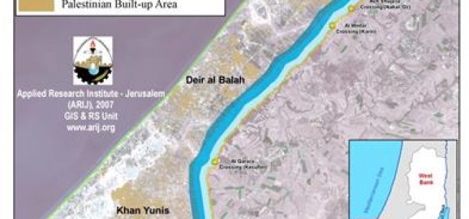
Israel increases the security buffer zone around the Gaza Strip
On June 28, 2007, Israeli sources revealed that the Israeli Army would mark the security zone to 1.5 km width on the Palestinian side along Gaza’s northern and eastern borders.

Three Palestinian villages are besieged by Israeli planning schemes
Hebron Governorate The Israeli planning and organization department affiliated to the so-called 'civil administration in Judea and Samaria' announced three detailed planning schemes for three Palestinian villages located to the
The Evacuation Charade of Israeli Outposts
General Glance The outposts' phenomena started in 1996 following the signing of the Oslo Peace Accord between the Palestinian Liberation Organization (PLO) and Israel in 1995, which also called for
