Blog
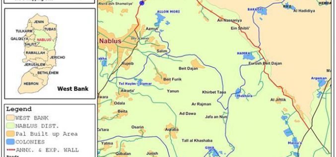
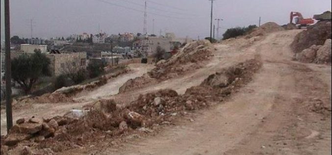
Nablus governorate: the land of Israeli checkpoints !!
Since the beginning of the second Intifada in September 2000, Nablus city has been cut off from the rest of the West Bank proper by Israeli military barricades, checkpoints and road

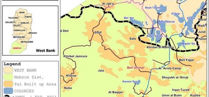
Hebron’s lands seized by road “security” fence !
The Israeli occupation forces issued last December three military orders for the purpose of creating a 'security' buffer zone along bypass roads south of Hebron district. The Military orders number
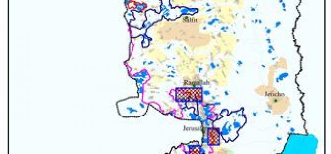
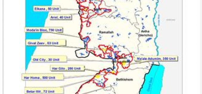
The Israeli Colonization activities in the Palestinian Territories during the 4th quarter of 2005 (October – December) / 2005
Click here for related case studies This report highlights the chronology of events concerning colonizing activities in the West Bank, Jerusalem and the Gaza Strip that occurred during the
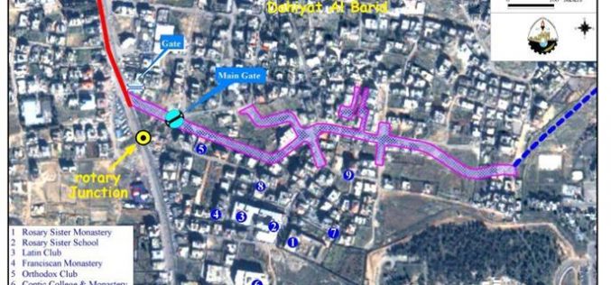
Enclaving Dahiyet Al Barid and Al Ram Territories !
On November 30, 2005, the Israeli court issued an updated map of the Wall section in Dahiyet Al Barid which showed two Wall gates, main and secondary, to be constructed
“Blue Sky” Operation
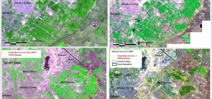
“Israel Makes up for its Concessions at Rafah with a Buffer Zone North of Gaza “
Israel recent activities in northern Gaza (create a buffer zone) is no surprise, in fact it comes as a natural consistent with Israel's disengagement plan. Northern Gaza area have experienced
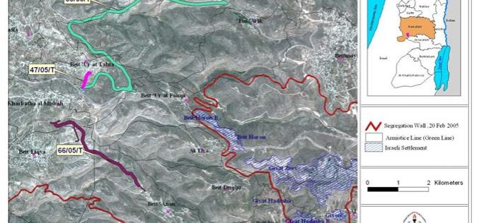
New Colonial Road to be constructed on lands of western Ramallah Villages.
In April 2005, the Israeli Occupation Forces handed out residents of western Ramallah villages, Beit 'Ur Al Tahta, Beit 'Ur Al Fauqa, Deir Ibzi, Beit 'Anan, Kharatha al Misbah and
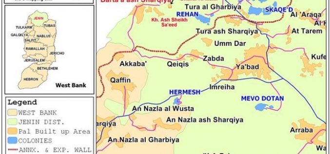
A new wave of demolitions in Barta’a Ash Sharqiyeh
Location, population and area Barta'a Ash Sharqiyeh (East Barta'a) is a border village located to the south west of Jenin city in Jenin governorate. It has the total population of
Israeli aggressions on Silwan’s land and real estates continued – Jerusalem Governorate
Once more Silwan is in the spotlight as feverish settlement activity targets it yet again. A report by the Land Research Center issued in September 2005 pointed out the possible
The ongoing Israeli Violations in The Jordan Valley !
The Jordan Valley is situated in the eastern part of the West Bank and includes the middle and lower parts of the Jordan Valley and the upper part of the
Amendment and New military orders for the Segregation Wall in several localities west of Bethlehem District
The Israeli Army issued an amendment to a previously issued military order to confiscate lands in order to build sections of the Segregation Wall in Beit Jala and several other

هدم المساكن العربية في القدس عام 2005 وسياسة التهويد المتسارعة
مثلما لم تبقى مادة من مواد الإعلان العالمي لحقوق الإنسان إلا وانتهكها الاحتلال الإسرائيلي فانه لم يبقى يوم من أيام عام 2005 إلا وفيه وصمة خزي وعار
Israeli demolition of Palestinian houses in Jerusalem continued unabated during 2005
The Israeli occupation authorities continued their hostile policies in Jerusalem during the year 2005. In this regard, the Israeli municipality of occupied Jerusalem, in collaboration with the ministry of interior
اعتداءات الاستيطان على أراضي وعقارات سلوان مستمرة محافظة القدس
Ù�رة أخرÙ� سÙ�Ù�اÙ� Ù�Ù� Ù�Ù�تصÙ� اÙ�دائرةØ� Ù�اÙ�Ù�جÙ�Ø© اÙ�استعÙ�ارÙ�Ø© اÙ�استÙ�طاÙ�Ù�Ø© تطاÙ�Ù�ا Ù�Ù� جدÙ�د. Ù�Ù�د اشار اÙ�تÙ�رÙ�ر اÙ�صادر عÙ� Ù�رÙ�ز أبØاث اÙ�أراضÙ� Ù�Ù� اÙ�Ù�Ù�Ù� 2005 ØÙ�Ù� استÙ�داÙ� 88 Ù�سÙ�Ù�ا Ù�Ù�
Christmas Present for Bethlehem: Tenders for 228 Israeli Housing Units
Bethlehem … Doomed by Israeli Colonization
It is no secret that Israel had its eyes fixed on Bethlehem after it occupied the West Bank during the 1967 war; starting with annexing 18,048 Dunums (4512 acres)
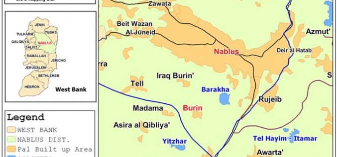
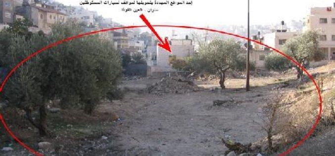
Burin olive orchards under settlers’ attack
Israeli settlers from Bracha and Yitizhar, Nablus region, cut hundreds of olive trees belonging to Palestinians from the village of Burin, Nablus governorate on December 15 and 25. Location, population
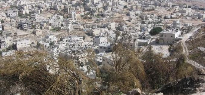
العيسوية: من قرية غنية باراضيها الى قرية مجردة من الارض
Ù�Ù�دÙ�Ø© Ù�بÙ�غ Ø·Ù�Ù� اÙ�جدار اÙ�عÙ�صرÙ� ØÙ�Ù� اÙ�Ù�دس اÙ�Ù�ØتÙ�Ø© ØÙ�اÙ�Ù� 100 Ù�Ù� Ù�Ù� جÙ�اتÙ�ا اÙ�اربع ØÙ�Ø« Ù�عزÙ� اÙ�Ù�Ù�ا عÙ�Ù�اØ� Ù�Ù�Ù�طع اÙ�صاÙ�Ù�ا Ù�Ù�Ù�Ù�Ù� تÙ�اصÙ�Ù�ا اÙ�اÙ�Ù�Ù�Ù�Ù� بجسÙ� اÙ�Ù�Ø·Ù�.

Al Isawiyeh: From a rich village to landless village
Introduction: The Israeli Segregation Wall is a colonial tool used to confiscate lands, water and to prolong the occupation. It penetrates through the lands of the West Bank from its
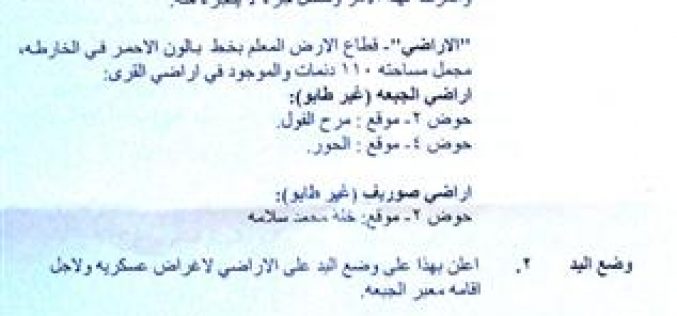
Al Jaba’a Border crossing under construction
On Tuesday, December 20th, 2005, the Israeli bulldozers started excavating lands of Al Jaba'a and Surif villages located inside Bethlehem and Hebron governorates for the establishment of a new Border
تطويب أراضي فلسطينية بأسماء مستوطنين يهود خطوة احتلالية تصعيدية خطيرة جداً . . . !؟
ان كافة القوانين والمواثيق الدولية والتي قد حفظت حقوق الملكية لاصحابها اثناء الحروب، وقد أكدت على ان جيش الاحتلال أو دولة الاحتلال عليها الاستمرار بتطبيق القوانين التي كانت سائدة،
سلطات الاحتلال الاسرائيلي ترتكب المزيد من الانتهاكات بحق سكان محافظة قلقيلية
Ù�Ù�Ù�Ù�Ù�Ù�Ø© – اÙ�Ù�Ù�Ù�ع Ù�اÙ�سÙ�اÙ�: تÙ�ع Ù�دÙ�Ù�Ø© Ù�Ù�Ù�Ù�Ù�Ù�Ø© Ù�Ù� اÙ�جزء اÙ�Ø´Ù�اÙ�Ù� اÙ�غربÙ� Ù�Ù� اÙ�ضÙ�Ø© اÙ�غربÙ�Ø© Ù�تبتعد 14Ù�Ù� Ù�Ù� شاطئ اÙ�بØر اÙ�أبÙ�ض اÙ�Ù�تÙ�سطØ� Ù�تÙ�ع عÙ�Ù� Ù�Ù�Ø© اÙ�ØÙ�ض اÙ�Ù�ائÙ�
The Village of Salem Between the Israeli Military Occupation and the Israeli Settlements
Location: The village of Salem is located to the east of the city of Nablus. It borders the lands of the town of Dier Al Hatab from the north, Biet
Humiliation through the Israeli So-Called “Leniency Measures”.
Location and Population: The city of Qalqilia is located in the northwestern part of the West Bank about 14 kilometers away from the Mediterranean Sea. It is situated atop the
Israel persist on coercing realities on Palestinians and the Road Map
Apparently, the Gaza evacuation fueled both the Israeli settlers and government for that matter to fortify the settlement program in occupied West Bank. Even though signs of possible evacuation from
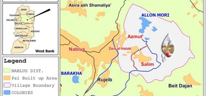
قرية سالم بين فكي الاحتلال الإسرائيلي و اعتداءات المستوطنين
تعرÙ�Ù� بÙ�رÙ�Ø© ساÙ�Ù�:- اÙ�Ù�Ù�Ù�ع Ù�اÙ�ØدÙ�د:- تÙ�ع Ù�رÙ�Ø© ساÙ�Ù� شرÙ�Ù� Ù�دÙ�Ù�Ø© Ù�ابÙ�سØ� Ù�تتبع Ù�ØاÙ�ظة Ù�ابÙ�س Ù�Ù� Ø´Ù�اÙ� اÙ�ضÙ�Ø© اÙ�غربÙ�Ø©. Ù�Ù�ØدÙ�ا Ù�Ù� اÙ�Ø´Ù�اÙ� اÙ�غربÙ� أراضÙ� بÙ�دة دÙ�ر اÙ�ØطبØ�

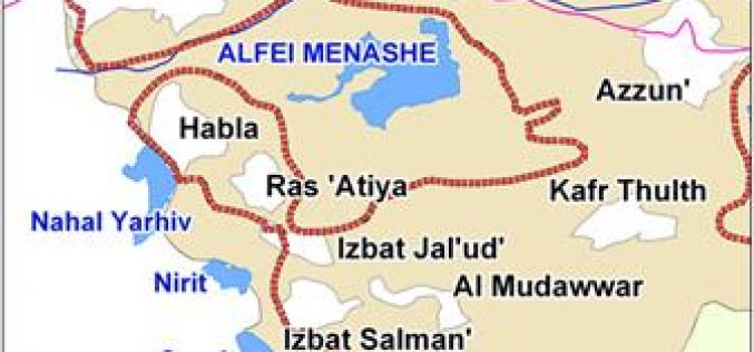
Zufim North – A new colonial nucleus over Jayyus’ segregated lands
Location, population and area: The village of Jayyus is located to the north east of the city of Qalqiliya. It is adjacent to the green line and parts of its
