Israeli Military Orders to extend the confiscation of 1280 dunums for Completing the construction of the Segregation Wall Northwest of Jerusalem
On January 5, 2012, the Israeli Army handed over residents of northwest Jerusalem area military orders extending the confiscation of 1280.68 dunums for the completion of building the Israeli Segregation Wall in the area. The military orders were issued on December 8, 2011 and were signed by the Commander of the Israeli Occupation Forces in the West Bank “Avi Mezrahi”. The targeted lands are located in the villages of Beit Duqqu, Beit Surik, Beit Ijza, Qatanna, Qubeiba, Biddu, An-Nabi Samuel and Beit Iksa.
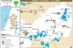
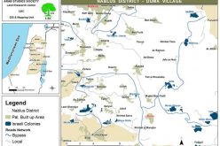
It is worth mentioning that the aforementioned military orders were issued by the Israeli Army to build the Segregation Wall in the area in the years 2003,2004,2005 and 2006 respectively. See map 1 and table 1
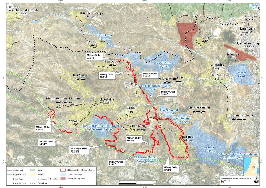
Map 1: The ten Israeli military orders targeting northwest Jerusalem vilages’ lands
|
Table 1: Details of the ten Israeli Military Orders
|
||||
|
No.
|
Military Order Number
|
Date of Issuance
|
Confiscated Area (Dunums)
|
Location
|
|
1
|
Dec, 8, 2011
|
22.5
|
Qatanna
|
|
|
2
|
Dec, 8, 2011
|
119.8
|
Biddu
|
|
|
3
|
Dec, 8, 2011
|
214.5
|
Beit Surik, Biddu, Qatanna
|
|
|
4
|
Dec, 8, 2011
|
149.7
|
Beit Iksa, Biddu, Beit Surik
|
|
|
5
|
Dec, 8, 2011
|
456
|
Al-Nabi Samuel, Beit Iksa, Beit Surik
|
|
|
6
|
Dec, 8, 2011
|
2.4
|
Beit Ijza
|
|
|
7
|
Dec, 8, 2011
|
116.08
|
Al-Qbeita, Qatanna
|
|
|
8
|
Dec, 8, 2011
|
61.5
|
Beit Surik
|
|
|
9
|
Dec, 8, 2011
|
18.4
|
Beit Dukku
|
|
|
10
|
Dec, 8, 2011
|
119.8
|
Beit Ijza, Biddu
|
|
|
Total
|
1280.68
|
|||
|
Source: (1) Qatanna Village Council – 2012
(2) ARIJ Field Team – 2012 (3) The Geo-informatics Department – ARIJ 2012
|
||||
The Segregation Wall Section Northwest of Jerusalem
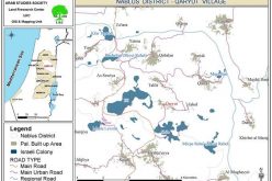
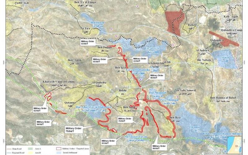
The latest revised route of the Israeli Segregation Wall issued by the Israeli Ministry of Defense in April, 2007 shows that the Segregation Wall route northwest of Jerusalem city extends a length of 38 km; starting from Beit Duqqu village in the northwest of Jerusalem and heading southwards to the villages of Beit Ijza and Biddu while encircling the village of beit Iksa village from three directions, isolating its most fertile agricultural lands and open spaces within the western segregation zone and trapping the built-up area in an enclave; The wall then extends westward to encircle Al Qubeiba and Qatanna villages while embracing the settlement of Har Adar and encompassing the Giv’at Ze’ev settlement Bloc, slicing between the aforementioned Palestinian communities and cutting them off from the center of Life in east Jerusalem. See map 2
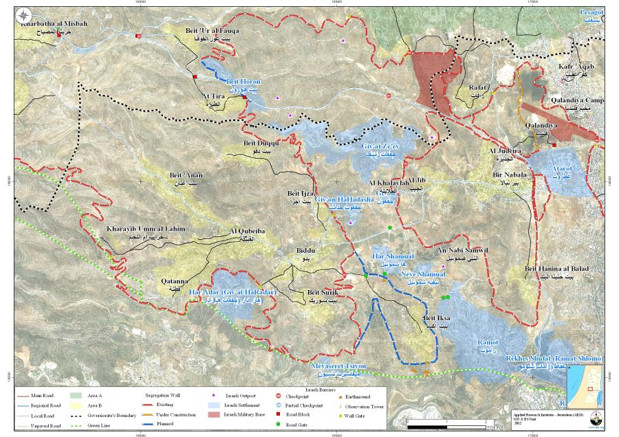
Map 2: the Segregation Wall northwest of Jerusalem
Moreover, the Segregation Wall section northwest of the city of Jerusalem will end up isolating 14,805 dunums from the eight Palestinian communities, which constitute 43.3% from the total area of these communities. See the table2 below:
|
Table 2: The Consequences of the Construction of the Segregation Wall on lands of Northwest Jerusalem villages
|
|||
|
Village
|
Total area-Dunums
|
Area Isolated by the Wall-Dunums
|
% from the total village area
|
|
Beit Duqqu
|
5456
|
54
|
1%
|
|
Beit Ijza
|
2525
|
608
|
24%
|
|
Beit Iksa
|
7732
|
7411
|
96%
|
|
Beit Surik
|
4243
|
1227
|
29%
|
|
Biddu
|
5285
|
1509
|
29%
|
|
Al-Qbeiba
|
3015
|
36
|
1%
|
|
Al-Nabi Samuel
|
2139
|
2139
|
100%
|
|
Qatanna
|
3792
|
1821
|
48%
|
|
Total
|
34189
|
14805
|
328
|
|
Source: The Geo-informatics Department – ARIJ 2012
|
|||
Beit Iksa Village, a special case
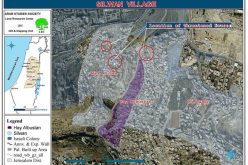
The Israeli Segregation wall plan of February 20, 2005, which was published on the website of the Israeli Ministry of Defense, showed that Beit Iksa village was trapped within the Giv’at Ze’ev settlement bloc. which Israel intends to annex to its proper upon wall completion; The map also showed that the village is isolated from the neighboring Palestinian villages northwest of Jerusalem city and the center of life in Jerusalem city as well. See Map 3
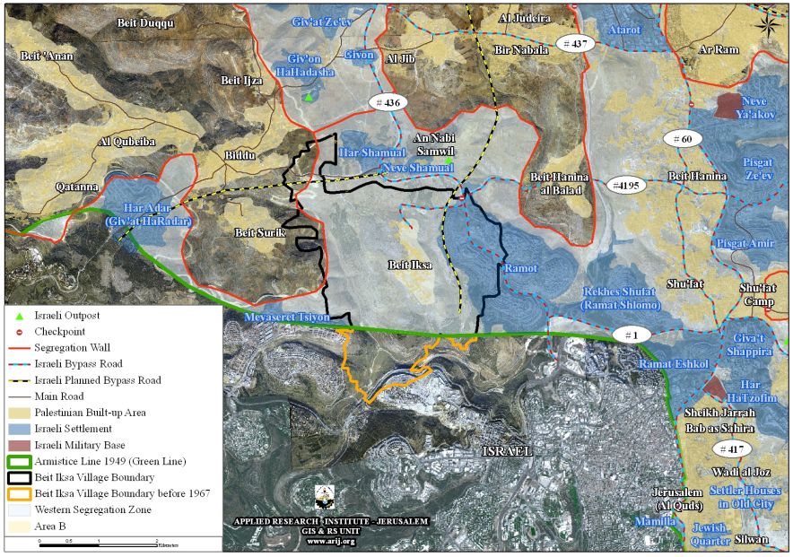
Map 3: The path of the Israeli Segregation Wall in Beit Iksa village in 2005
While the June 2006 and April 2007 revised routes published on the Israeli Ministry of Defense website site showed that the built-up area of Beit Iksa village was included within the northwest enclave which includes the villages of Beit Ijza, Beit Duqqu, Biddu , Beit Surik, Al Qubeiba and Qatanna; while the agriculture lands and the open spaces of the village’s lands were still trapped within the Giv’at Ze’ev settlement bloc, in the western segregation zone and residents of Beit Iksa village will no longer access them. It is worth mentioning that the Israeli Defense Ministry and after few weeks from publishing the April 2007 plan, it retracted the map of the Segregation Wall and reposted the April 30, 2006 map instead. However, on 29/7/2009 , the Israeli daily newspaper “Haaretz” revealed that the Israeli Defense Ministry had adopted the plan of April 2007, in which Beit Iksa village will became in the eastern side of the Wall while the agriculture lands as well as the rest of the village’s lands would become isolated in the western segregation zone (the area between the Segregation Wall path and the Green Line – Armistice Line of 1949), within the Giv’at Ze’ev settlement bloc. See Map 4
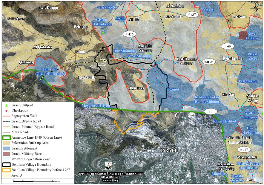
Map4: The path of the Israeli Segregation Wall in Beit Iksa village in 2007
Beit Duqqu is a Palestinian village located about 17 km away from the city of Jerusalem and is inhabited by 1762 residents (PCBS 2012). It is bordered by At-Tira village to the north, Al-Qbeiba village to the south, Giv’at Ze’ev illegal Israeli settlement along with the Israeli Segregation Wall to the east and Beit ‘Anan to the west.
The construction of the Segregation Wall has led to the confiscation of two natural springs in the village used for agricultural purposes and villagers of Beit Duqqu are no longer able to use these two springs
Beit Surik village is bordered by Biddu village to the north, the Segregation Wall as well as the illegal Israeli settlement of Mevezeret Zion to the south, the Segregation Wall section to the east, Al Qubeiba village along with Har Adar illegal settlement to the west. The total population of Beit Surik is 4226 residents (PCBS 2012).
The village of Beit Surik lost 1296 Dunums (31%) of its total land area (4244 dunums) for the construction of the Israeli Segregation Wall. The wall, once completed, will surround the village of Beit Surik from three sides, east, west and south and will snatch most of its agricultural lands and other natural resources; but more importantly, the Segregation Wall route will annex the settlement of Har Adar to Israel’s proper.
Qatanna, a Palestinian village located 12 Kilometers to the northwest of the city of Jerusalem. It has an area of 3793 dunums, including 373 dunums as built-up area and is currently inhabited by 7022 (PCBS 2012). The village of Qatanna is surrounded by the Palestinian village of Beit ‘Anan form the north, the illegal Israeli settlement of Har Adar from the south, the Israeli Segregation Wall from the south and west, and by Biddu village from its east. The Segregation Wall in Qatanna village extends a length of 6 kilometers and isolates 1821 dunums of its lands, 48% of the total village’s lands.
Al-Qubeiba is bordered by Beit Duqqu village to the north, the Segregation Wall as well as the illegal Israeli settlement of Har Adar to the south, Biddu village to the east and Kharayeb Em-Al-Lahem to the west. The total population of Beit Surik village is 3449 residents (PCBS 2012).
Beit Ijza is a Palestinian village located 10 km northwest of occupied East Jerusalem. The village has an area of 2525 dunums and houses a total population of 759 inhabitants (PCBS, 2012). The village is surrounded by Beit Duqqu from the northwest, Beit Annan from the west, Al Qibeiba village from the southwest, Biddu from the south and the Giv’at Ze’ev settlement bloc from the east. According to the Segregation Wall Plan, 22% (566 dunums) of Beit Ijza village’s lands are isolated west of the wall and are inaccessible by its owners
Biddu village lies 9 km northwest of the city of Jerusalem and occupies an area of 5285 dunums, including 500 dunums (8%) as the built up area and houses a total population of 7391 residents (PCBS 2012).
It is bordered by Beit Ijza village to the north, Beit Surik to the south, Al-Qubeiba village to the west and the Segregation Wall to the east. About 29% of Biddu’s lands are isolated west of the Segregation Wall route where access to these lands is limited (seasonal) and according to the Israeli measures, residents must get a special permit from the Israeli Civil Administration in order to be able to access their segregated lands.
Al-Nabi Samuel is bordered by the village of Al-Jeeb as well as the Segregation Wall from the north, the illegal Israeli settlements of Ramot and Neve Shamuel from the south, Beit Hanina Al Balad along with the Segregation Wall from the east and the Israeli settlement of Har Samuel from the west. The village occupies a total land area of 2140 dunums including 65 dunums (3%) comprising the village’s built up area which houses a total population of 281 residents (PCBS 2012).
Al- Nabi Samuel village lost more than 90% of its lands for the construction of the Israeli Segregation Wall. More than that, the village is set in an enclave, totally segregated from the nearby Palestinian villages.
Beit Iksa village lies about 9 km northwest of Jerusalem city. It is bordered by Al-Nabi Samuel village along with the Segregation Wall and the illegal settlement of Neve Samuel to the north, the Green Line (the Armistice Line of 1949) as well as the Segregation Wall to the south, Beit Surik village and the Segregation Wall to the west, Ramot settlement and the Segregation Wall to the east. The total area of the village is 7732 dunums and is inhabited by 2060 residents (PCBS 2012). Upon wall completion, 7411 dunums (96%) from the village’s total area will be totally isolated west of the Wall and annexed to Israel.
Legal & International Status
Israel continues with the construction of the Apartheid Segregation Wall in the occupied Palestinian territory, violating the Palestinians’ civil rights for freedom of movement, freedom of religion and proper health services and education, right to work, and also the right of live adequately in their houses and areas of their choice without restrictions, all of which guaranteed by the International law rules and human rights conventions.
-
The ICJ Advisory Opinion on the Legal Consequences of the Construction of a Wall in the Occupied Palestinian Territory in July 9, 2004. “The Court has reached the conclusion that the construction of the wall by Israel, the occupying power, in the Occupied Palestinian Territory including in and around East Jerusalem and its associated régime, is contrary to international law and has stated the legal consequences that are to be drawn from that illegality”. Also “Israel is under an obligation to make reparation for all damage caused by the construction of the wall in the Occupied Palestinian Territory, including in and around East Jerusalem.”
-
Also Articles 53 &147 of the Fourth Geneva Convention indicated that: Extensive destruction and appropriation of property not justified by military necessity and carried out unlawfully and wantonly. is a grave breach of the Convention.
-
Art. 23 of the Hague Convention of 1907 also provides: In addition to the prohibitions provided by special Conventions, it is especially forbidden to destroy or seize the enemy’s property, unless such destruction or seizure be imperatively demanded by the necessities of war.
-
Under the Universal Declaration of Human Rights Adopted and proclaimed by General Assembly resolution 217 A (III) of, December 10, 1948, Article 17 reads: ‘No one shall be arbitrarily deprived of his property.’ Which means it bans Israel from destroying or confiscating the property of the Palestinians at any case.
-
The Israeli Occupation practices in the occupied Palestinian territory and especially in the city of Jerusalem clearly violate the Palestinian human rights under international law and the fourth Geneva Convention of 1949 systematically, which constitute a crime of apartheid according to the International Convention on the Suppression and Punishment of the Crime of Apartheid (1973) which defines apartheid as: ‘the imposition of various legislative measures on different racial groups while injuring the rights of one. Moreover, the crime of Apartheid comprises a ‘crime against humanity’ and ‘a serious threat to international peace and security.
::::::::::__
[1] Israeli Settlements comprising the Giv’at Ze’ev settlement bloc are: Giv’at Ze’ev, Giv’on, Giv’on Hadasha, Har Shamuel, Neve Shamuel and Ramot.
Prepared by
The Applied Reserach Institute – Jerusalem
The Applied Reserach Institute – Jerusalem

Categories:
Military Orders