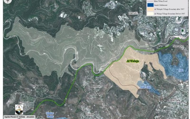
Al-Walajeh is a Palestinian village located about 4 kilometers northwest of Bethlehem city and 8.5 km southwest of the city of Jerusalem. It has a population of approximately 1,800+ residents.Before the 1948 war, the village spread over an area of 17.793 km2 and its boundaries extended westwards beyond the 1949 Armistice Line (Green Line). During the 1948 war, the village lost 75% of its lands and came to spread over just about 25% of its original area (4.403 km2). The Palestinian built up area covers only the 4.5% of the total area, while the majority of the lands of the village are fields of shrub and herbaceous vegetation and open space with little or no vegetation.
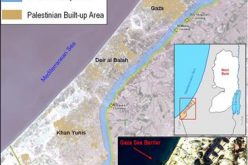
In 1967 after the Israeli occupation of the West Bank and the Gaza Strip, the Israeli government unilaterally expanded Jerusalem Municipal boundary from 6.5 km² to 71 km² to include lands from nearby villages, these lands where then annexed to the state of Israel. Part of Al-Walajeh village -Ein-Juwaiza neighborhood- an area of 2.095 km2 –almost 48% of the remaining area-was included within this annexed land. See Map 1
Al Walajeh Village before and After the 1967 War
During the last 4 decades of Israeli occupation, Al-Walajeh village witnessed an escalation of violations. Incessant military orders were issued against the proprieties of the inhabitants of the village who faced the loss of their lands and the demolition of their homes for the illegal expansion 'Jerusalem Municipality boundaries'. Consequently, an Israeli built-up area was set up; the village has been downsized and surrounded by settlements in continuous expansion, by 'by pass roads' and according to the updated route of the Segregation Wall (September 2007), Al-Walajeh will be totally enclosed with a single but Israeli controlled exist to the main urban areas of Bethlehem governorate where the main services are located.
Land Classification
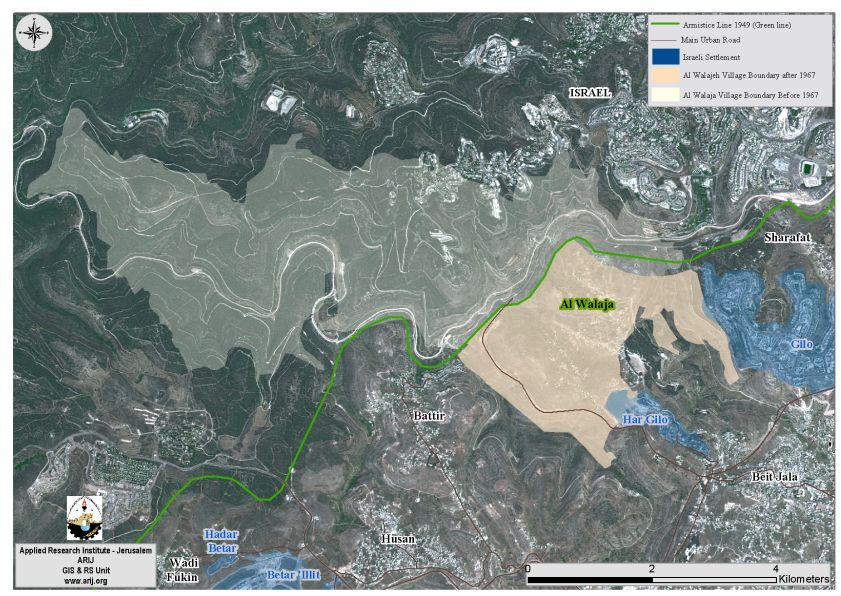
The Oslo II Interim Agreement signed in September 1995 between the Palestinian Liberation Organization (PLO) and Israel, concluded Israel withdrawal from areas of the West Bank, and that the Occupied Territory be classified into Areas “A,” “B” and 'C,' designating varying levels of control. See table 1-section1. Under the signed agreement, Al-Walajeh village was fragmented to the areas “B” and 'C.' sees table one-section 2.
-
Area B constitutes the 2.6% of the land (0.14km²) of the total area of the village, and includes the urban area of the village.
-
Area C constitutes the remaining 97.4% (4.289km²) of the total area of the village, and includes all the agricultural lands, the open spaces, and all the lands suitable for future expansion.Table 1
|
Section1 |
AreasDefinition in Oslo II Interim Agreement of September 1995 | ||
| AreaA | The Israeli armyhas pulled out fully and Palestinians hold all responsibilities for internalsecurity and Public order. | ||
| Area B | Palestinianshave full control over the civil administration and Israel continues to haveoverriding responsibility for security. | ||
| AreaC | The Palestinianshave responsibility for civil life such as economics, health, and education; while, Israel retains full control over security and administration related tothe territory. | ||
| Section2 | Area inKm2 | % |
|
| AreaB | 0.14 | 2.6 |
|
| AreaC | 4.289 | 97.4 |
|
| TOTAL | 4.403 | 100 |
|
Source: ARIJ GIS UNIT 2008
It means that Palestinians do not have any effective control over the land of their village and they are prohibited from utilizing any of the area reserved for expansion or any thing else for that matter without the authorization of the Israeli side.
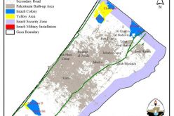
In fact, area 'B' is were Palestinians have semi control over the civil responsibilities while Israel continues to have overriding responsibility for security; and in area 'C', which includes all the area suitable for the growth of the village, Palestinians have civil life responsibility such as economics, health and education; however, Israel retains full control over security and administration related to territory. Accordingly, and since all the open spaces available for the villagers to use are situated in Area C, Palestinians have to acquire a license from the nearest Israeli Civil Administration (ICA) for every construction. See Map 2
The impracticality of attaining a building license (permit) is another story, as Palestinians must meet a list of demands set by the ICA to prove ownership of the land where premises are to be constructed. However, the permits are frequently rejected, thus the Palestinian residents at such areas -C- have no choice but to build without the authorization, which happen frequently by the Palestinians who are compelled to take such action to deal with the population growth and the increasing need for education, health, and other necessities to their daily lives.
This translate in reality where Palestinians are obliged to suffer the consequences of the Israeli military orders of land confiscations, houses demolition under the pretext of being built without a license, which in turn becomes order for the expansion of the existing settlement, for the construction of the Segregation Wall, to increase the buffer zone area, and for setting-up by pass roads.
Occupation practices in Al-Walajeh :-
1- Settlements
Due to its tactical location, the close proximity to Jerusalem and the Green Line, for this, it is very much exposed to the illegally Israeli defined Jerusalem Municipality boundaries', Al-Walajeh has been a prospect target of the Israeli colonization activities. Gilo and Har Gilo are the two Israeli settlements partially located on lands confiscated from Al-Walajeh. These settlements are among the first wave of Israeli colonization activities in the occupied West Bank, some 123 Dunums of lands have been confiscated from the village to build the Israeli settlements.
In 1971, Gilo settlement was established in the east border on Al-Walajeh, Har Gilo settlement was then established in 1972 to occupy the southeast part of the village. Following the outbreak of the second Intifada in the year 2000, the Israeli government worked to confiscate more Palestinian lands in an attempt to expand the borders of the settlements. Vast areas of lands were razed and several hundreds of new housing units were added to the settlements.
Currently, the two settlements cover a surface of a total of 3144 Dunums of land- all expropriated from surrounding Palestinian villages – and include a total population exceeding 35.000 settlers.
The settlements around Al-Walajeh are in continuous expansion, the Master Plan for each Gilo and Har Gilo settlements are redrawn in sequence of the Segregation Wall route, which clearly show the future expansion plans for both settlements, which are already taking place on the ground. Now, with the two settlements enclosed within the Western Segregation zone, the cost to the Palestinian village Al-Walajeh, as many other Palestinian communities are immense; losing more of the little remaining lands, which will consequently be separated behind the Segregation Wall.
Even right after Annapolis conference of November 2007, in which the freeze of Israeli settlements in the West Bank was decided as an initial step to re-launch the latent peace process; the Israeli Land Administration (ILA) revealed a proposal-plan to construct several hotels buildings in Gilo settlement on six dunums of land, with an option to turn these hotels plans to hundreds of housing units when needed.
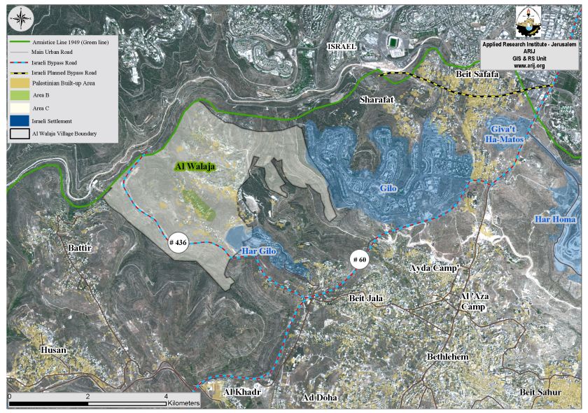
2- Bypass Road #436
Bypass roads, as they were initiated in 1993 with the signing of the Declaration of Principles between the Israeli State and the Palestinian Liberation Organization (PLO), were designed for the Israeli Army and populations of the settlements use, to bypass Palestinian towns and communities in the context of Israeli Army redeployment. By contrast, Israel intensified the construction of Bypass roads all over across the West Bank, embezzling, for this purpose, sizeable areas of Palestinian land, breaking up the territorial contiguity between Palestinian communities even more than ever before. What make things worse is that Palestinians are prohibited to use these Bypass roads. In Bethlehem Governorate, the Bypass roads system stretch on 79 km with additional 30 km to be constructed by the end of 2009. The bypass roads are designed with security buffer zones, which require additional 75-meters in width of land on each side of the road, causing even additional damages to those inflicted by the bypass roads.. The Israeli Army controls the bypass roads as they control the security buffer zones and the access to them is severely restricted for Palestinian. Over all the, the bypass road system occupies 16.5 km2 (2.8%) of Bethlehem Governorate total land area.
Over the past years, Al-Walajeh village were served with many military orders issued by the Israeli Army to confiscate land and demolish homes thus driving many Palestinian residents to poverty and to be homeless. The Israeli Bypass Road #436 had much to do with these orders. Now the village is bordered from its southern side by this bypass road, which consumed more than 500 Dunums of its lands. This road originates from the west side of Jerusalem city to connect the settlements of Giv'on and Ramot Alon, which lie on the same route. The bypass road then continues southwest to penetrate Al-Walajeh village lands from the west and moves eastwards to the Settlement of Har Gilo, southeast Al-Walajeh village to connect with bypass Road number 60.
On December 15, 2005, the Israeli forces distributed a new military order (Order Regarding Closed Zones, Judea and Samaria, No. 34, 5727-1967) that forbids Palestinians; even those holding valid permits from entering Israel via bypass roads, including Road 436, thus confining its use to Israeli settlers. See Map 2
3- The Segregation Wall in Al-Walajeh
According to the updated Wall plan of April 30, 2006, the Wall will place Al Walajeh village in an isolated enclave, sealed off from all directions, east, west, north and south and from the neighboring Palestinian communities; Battier, Hussan, Beit Jala and from Bethlehem city center. The Wall, according to the map, was shifted northwards to include the neighborhood of 'Ein Al Juwaiza on the Palestinian side of the Wall, but sealed off the village completely from its southern part with a 2.5 km long Wall that will run alongside bypass road number 436, and will be protected from both sides with barbed wires and ditches (ranging between 80 and 100 meters wide).The road protection will cause the isolation of an additional 1100 dunums of lands from Al Walajeh village, where these lands will fall south of the Wall and will be inaccessible to the Palestinian residents.
In Total, the Israeli segregation Wall plan will extend for 7.2 km on the lands of Al Walajeh, of which 3.5 km will be barbed wires. The Wall will isolate a total sum of 1980 dunums of the village's lands that is 45 % of the total village area. Currently 0.5 km of concrete wall exists around the village, 1.2 km are under construction and 5.5 km are in planning phase to be constructed around the village before the end of 2009.
The Enclavement of Al-Walajeh through the Segregation Wall and a Crossing point
The Israeli closure and isolation policy started in Al-Walajeh just about the time the peace process was initiated in the early 1990’s but intensified after the second Intifada in 2000, when the village was completely isolated from its surrounding environment. The Israeli Army started with several procedures to restrict the movement of the residents in Al-Walajeh to a single exit and entrance point. The road that leads to Beit Jala through Cremisan monastery was closed with an earth mound, which is a pile of rubble and a trench to keep the cars from moving on that road. This is a temporary procedure; at least until a more effective one is employed that will guarantee non-movement for vehicles and individuals all the same. The other, current, and single entrance and exit point from and to Al-Walajeh is at the village’s south side, which is also nearby the western entrance of the Israeli Har Gilo settlement. However, the permanent checkpoint at the western side of Beit Jala and literally the only breathing spot for Al-Walajeh residents was the major problem, as the Israeli Army was constantly closing it off. The checkpoint was established after the year 2000 and continued to constitute a problem for some time, until the year 2004 when it was removed as the Segregation Wall was starting to shape up in the vicinity. Even though that the checkpoint does not exist as a permanent point anymore, the location has turned into an occasional “flying” checkpoint.
-
Al Walajeh Terminal
-
Function: A Crossing Terminal
-
Status: Planned
On February 19, 2006, the Israeli Occupation Army issued a new military order (#25/06/T) to confiscate 39.8 dunums from Al-Walajeh village (parcel Block 3) and Beit Jala city (parcel Block 2). The order identified the reason for the confiscation to “military purposes,” which was later defined for the construction of a new Terminal in the area, (Har Gilo Terminal). The terminal aims to control movement of Al-Walajeh residents between their village and the center of services in Bethlehem Governorate and beyond. The military order comes in parallel to the Israeli Segregation Wall plan, which is set to encircle Al-Walajeh. Residents of the village will only have this terminal to move in and out of their village. The terminal will be under the Israeli Army’s control, which virtually makes the residents prisoners in their own village. See Map 3

Al-Walajeh's resources isolated by the segregation plan
According to the updated segregation plan, 2210 Dunums of the Village will be isolated behind the Segregation Wall, and will only be accessible to the landowner through valid Israeli issued permits.
Agricultural areas: Up to 115 dunums, 32% of the total heterogeneous agricultural area of the Al-Walajeh (385 dunums), will be isolated by the Segregation Wall.
Open Spaces: 735 dunums, 89% of the total area of open spaces of Al-Walajeh (821 dunums) will be segregated by the wall.
Forests: More than 180 dunums of forest have been appropriated by the segregation wall (96% of the total forests of the village).
Entrance to the isolated agricultural lands will only be limited to those who are able to prove landownership with land deed titles authenticated by the civil administration. More than that, only the owners whose names listed in the ownership deeds (usually the eldest of the families) or their inheritors will receive permits. Furthermore, the Israeli civil administration will only issue permits on seasonal basis. Hence, the owners will find a hard time to manage the cultivated lands on their own especially that the permits will likely not include additional labor or equipments.
Table-2 below shows the Land Use/Land Cover of Al-Walajeh village and
the land Use/Land Cover of the areas isolated by the Segregation Wall.
|
Table-2: The impact of the Israeli Segregation Wall on Al-Walajeh village Land Use/Land Cover areas |
|||
|
Item |
Total Area (in Dunums) |
area isolated by the Wall |
Percentage |
|
Arable land |
247 |
133 |
54% |
|
Forest |
188 |
181 |
96% |
|
Permanent crops |
997 |
260 |
26% |
|
Heterogeneous area |
385 |
115 |
32% |
|
Mine, dump and construction sites |
66 |
59 |
85.5% |
|
Open spaces with little or no vegetation |
821 |
735 |
89% |
|
Shrub and/or herbaceous vegetation associations |
1380 |
610 |
44% |
|
Palestinian Built-up area |
196 |
4 |
2% |
|
Jewish settlement |
123 |
113 |
92% |
|
|
|
|
|
|
Total |
4403 |
2210 |
50% |
Source: ARIJ database- GIS, 2008
Houses Demolition Policy
In 1985, the Israeli municipality of Jerusalem started issuing demolition orders to dozens of houses constructed in Ein-Juwaiza neighborhood under the pretext of having no building license and violating the Israeli building codes. The area targeted for demolishing “Ein-Juwaiza neighborhood” falls effectively within the illegally Israeli redrawn Jerusalem Municipal boundary after the 1967 war.
The neighborhood has 70+ houses, most built without licenses. Since the second Intifada in the year 2000, the number of actual demolitions exponentially increased. It was obvious that Israel aim force it will on the ground and send a message of who is in control there but more than that to make room for future colonization plans; to gain space in order to expand the existing settlements, to build the Segregation Wall and bypass roads.
The Israeli actions are clear and indisputable form of collective punishment practiced against Palestinian civilians in Al-Walajeh village, in order to make them surrender and leave the area in voluntarily manner.
Table-3 below shows some of the recorded demolitions of structures belonging
to residents of Al-Walajeh village and of Ein-Juwaiza neighborhood between 2002 and 2007.
|
Date |
Structure Type |
Area of structure |
location |
pretext |
|
02/06/2002 |
2 homes & 1 health clinic |
|
Al-Walajeh |
settlement expansion |
|
14/03/2003 |
3 homes |
|
Al-Walajeh |
building without permit |
|
13/08/2003 |
5 homes |
|
Ein-Juwaiza |
building without permit |
|
11/3/2004 |
1 home |
two-storey |
Al-Walajeh |
|
|
1/4/2004 |
1 store |
|
Al-Walajeh |
|
|
19/05/2004 |
1 home |
|
Al-Walajeh |
building without permit |
|
21/06/2004 |
2 homes |
two floors |
Ein-Juwaiza |
settlement expansion |
|
17/01/2005 |
3 homes & 1 store |
|
Ein-Juwaiza |
building without permit |
|
04/01/2006 |
1 home |
two-storey |
Ein-Juwaiza |
building without permit |
|
30/01/2006 |
2 homes |
150 m² |
Ein-Juwaiza |
building without permit |
|
05/02/2006 |
1 home |
140 m² |
Ein-Juwaiza |
building without permit |
|
22/03/2006 |
2 homes |
100 m² |
Al-Walajeh |
building without permit |
|
30/03/2006 |
2 poultry farms |
|
Al-Walajeh |
building without permit |
|
12/12/2006 |
1 home |
|
Al-Walajeh |
building without permit |
|
09/05/2007 |
1 poultry |
70 m² |
Al-Walajeh |
building without permit |
|
18/11/2007 |
1 poultry |
60 m² |
Al-Walajeh |
|
|
Total |
35 |
|
|
|
Source: ARIJ Monthly Reports Database – 2008
In the period between 2003 and 2007, 14 military orders have been issued by Israeli administration, which commanded the confiscation of many dunums of land, the demolition of houses and the consequent isolation of the village in an enclave. Below are some of the most significant.
4- Military Orders
Chronology of issued military orders since 2003
Year 2003
-
T/44/03 : On July 3, 2003, the Israeli Chief Commander of Judea and Samaria issued military order number T/44/03 stipulating the confiscation of 23.8 dunums from Al-Walajeh and Beit Jala for the Segregation Wall. The section of this order that lies in Al-Walajeh is believed to be cancelled as the Israeli updated map approved by the Israeli Government on February 20h 2005 and published on the Israeli Ministry of Defense’s website outlines a different route for the Wall in this area. The section of this order that lies in Beit Jala was updated by military order number T/32/04.
Year 2004
-
T/32/04 : On March 25, 2004, military order number T/32/04 was issued for the confiscation of 175.6 dunums from Al-Walajeh and Beit Jala lands. This order was updated in November 2005.
Year 2005
-
T/75/05: On March 22, 2005, the Israeli authorities issued military order holding number T/75/05 to confiscate 9.2 dunums from Block 2 in the areas of Al-Rewaset and Al Basa from the lands of Beit Jala and in Block 3 in Al Serj area from Al-Walajeh.
-
T/85/05 : On April 1, 2005, the Israeli Occupation Force issued military order number T/85/05 stating the confiscation of 14.3 dunums of Beit Jala and Al-Walajeh lands for a section of the Segregation Wall. This Wall Section is located at the northwestern part of Beit Jala between Cremisan forest and Al-Walajeh.
Year 2006
-
T/25/06 : On February 9, 2006, the Israeli Occupation forces issued a new military order in Beit Jala city and Al-Walajeh village to confiscate 39.8 dunums of land for the construction of a Terminal west of Har Gilo settlements. The terminal will control the movement of residents in and out of the village.
-
T/66/06 : On March 30, 2006, the Israeli authorities issued a new military order to confiscate some 90 Dunums of lands to construct a 1.9 Kilometers length road alongside the eastern route of the Segregation Wall. The road is being constructed to facilitate the access of Israeli settlers of Har Gilo to Jerusalem. This road will isolate more than 839 dunums of lands from Al-Walajeh, which will simply be annexed within the Israeli declared Jerusalem Municipality boundary.
-
T/67/06: On April 27, 2006, the Israeli Ministry of Defense handed out residents of Beit Jala city and Al-Walajeh village a new military order, stating the confiscation of 317 dunums for the construction of a 3.8 km long part-section of the Segregation Wall. Out of the total area declared for confiscation, 291 dunums to be confiscated from Al-Walajeh village. In addition, the military order showed a shift in the Wall route in Al-Walajeh village at the northern part, which included the neighborhood of 'Ein-Juwaiza on the southern side of the Wall. This shift was an update to the February 20, 2005 Wall map which included part of 'Ein-Juwaiza neighborhood north of the Wall.
Major Impacts of the Segregation Plan
The construction of the Segregation Wall has negative impacts on the political, economic, social, as well as environmental aspects of the Palestinians' life. Following is a summary of those major impacts:
-
The Segregation Plan intends to keep more than 50% of Al-Walajeh Land under Israeli control within the Western Segregation Zone
-
Harsh measures are imposed on Palestinians' mobility and movement, transportation from or to the Segregated areas.
-
Increased urbanization pressure and population density
-
The Segregation plan is creating new demographic facts that will lead to forced migration among Palestinians who will loose their livelihoods.
-
The Segregation Plan causes severe damages to the Palestinian agricultural sector and to the Palestinian farmers; as a result of land confiscation and the constraints imposed on mobility and marketing
-
Unemployment as well as poverty levels will increase
-
There will be no places for landfills or waste water treatment sites
-
Natural resources will decrease, forests, pastures, open spaces and recreation areas will be extremely limited
-
Loss of grazing area and increase in desertification
-
A distortion in wildlife movement as a result of cutting-off different kinds of species from their natural habitat
-
The Segregation Plan is altering the Palestinian natural landscape
-
Many archeological and historical sites related to the Palestinian cultural heritage will be segregated behind the Wall
-
Loss of open space which poses a threat to the sustainability of the urban and rural areas as well as a threat to more losses of the natural resources and biodiversity
The International Legal Status of the Segregation Wall
In July 2003, the International Court of Justice (ICJ) passed an advisory opinion declaring that the Wall Israel is constructing is illegal. The Court based its decision on international law, including the Fourth Geneva Convention, the Hague Regulations, various human rights treaties and United Nations Security Council resolutions.
The Segregation Wall results in the violation of human rights including the right to Self-Determination, the right to freedom of movement, the right to work, the right to medical treatment, the right to education, the right to an adequate standard of living and access to holy places. The ICJ decision upholds the right to self-determination of the Palestinian people, which they are prevented from exercising by the Wall's disruption of the territorial integrity and unity. 'Self-defense' or 'state of necessity' can not be used as justification for violating this right and other international legal principles and therefore Israel must cease construction and all other states must refrain from supporting Israel in building the Wall.
Moreover, the construction of the Segregation Wall is a violation of all peace agreements signed between the Israelis and Palestinians and a breach of the Oslo Interim Agreement which states that: “Neither side shall initiate or take any step that will change the status of the West Bank and the Gaza Strip pending the outcome of the permanent status negotiations” (Article XXXI, clause 7).
Conclusion
Even thought the international community has refused Israel’s argument on the Segregation Wall, Israel still proceeds with apathy with its unilateral plans to build the Segregation Wall; confiscating in the process large tracts of Palestinian lands. If this continues, the urban area in Bethlehem Governorate, especially in Al-Walajeh village stands to lose half of its land and the village’s built-up area will be completely surrounded by a complex of Walls, settlements and roads that will prevent any future possibility for the community to expand and will jeopardize sustainable development.
Prepared by
The Applied Research Institute – Jerusalem