Location and Population
The village of Al Isawiya is located some 2.5 km east of the 1949 Armistice Line (Green Line) and 3 Km northeast of Jerusalem city. The total area of Al Isawiya villages clusters is 15489 Dunums – (Al 'Isawiya, Shu'fat, and Shu'fat Camp). Al 'Isawiya village is a home to nearly 12000 inhabitants (PCBS 2006).
Military Bases
The Israeli military bases were established in the Palestinian Governorates following the 1967 war and played a significant role in the methodical and premeditated Israeli strategy to create a reality that contravenes the international law.
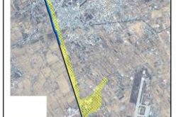
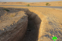
On April 27, 2007, the Israeli authorities confiscated 40 dunums of lands owned by Abu Ryala family in Al 'Isawiya village, in Jerusalem Governorate, in order to expand the existing military base located east of the Bypass road # (1) leading to Ma'ale Adumim settlements Bloc. This military base was established back in 1978 on confiscated lands from of Al 'Isawiya village lands and provide protection and security for to Ma'ale Adumim settlements Bloc. In 1985, the military base augmented in area to 725 Dunums, the majority of which came from confiscated lands from Al 'Isawiya village. A satellite photo analysis in 2002 showed an additional increase to the area of the base that turned to 963 Dunums, of which 628 Dunums (65%) sets within Al 'Isawiya village boundary.

The latest 40 dunums confiscation episode from Al 'Isawiya village represented the latest edition to the military base. It came as a 6% increase to the area of the military base that exists in Al 'Isawiya village, which became 668 Dunums. On the other hand, the total area of the Israeli military base became with the new addition 1003 Dunums, an increase by 4%.
Al 'Isawiya village boundary has a second base located at the south side of the village’s built-up area. It spread on 77 Dunums of confiscated lands and designated to provide protection to Israeli settlers of (Har HaTzofim) settlement (southwest); also to secure safe passage for their movements toward Jerusalem. Today, the two military bases occupy a total area of 1080dunums (7 %) of Al 'Isawiya villages cluster.
The Ring Road Project
The Ring Road project consists of Roads 5 & 45. The Israeli Mariah company (Jerusalem Development Company) finalized its planning in 1996. It aims to connect the Israeli settlements in the southern part of Jerusalem, Gilo, and Har Homa (Abu Ghniem) with settlements further to the north within Ma'ale Adumim bloc all the way to the heart of Jerusalem.
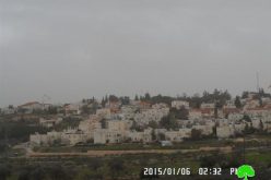
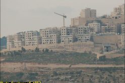
Israeli settlements established within Al 'Isawiya villages cluster
Seven Israeli settlements were established in the Al 'Isawiya villages cluster following the 1967 war, the time when Israel occupied the West Bank (including East Jerusalem) and the Gaza Strip. Today, these settlements occupy a total area of 3422 dunums (22 %) of the villages’ original 15489 Dunums land area. Table 1 shows the status of the established seven Israeli settlements.
Table 1: List of Israeli settlements constructed within Al 'Isawiya villages cluster
|
Israeli Settlement |
Date of establishment |
Population 2002 |
settlement's Area (2005/ Dunums) |
Of which inside Al 'Isawiya village Boundary (2005/ Dunums) |
|
Givat Shappira |
1968 |
8207 |
688 |
688 |
|
Hebrew University (Har HaTzofim) |
1968 |
1306 |
957 |
558 |
|
Ramat Eshkol |
1968 |
31560 |
1118 |
544 |
|
Mishr Adummim (Industrial Zone) |
1974 |
2 |
3378 |
495 |
|
Ma'ale Adumim |
1975 |
27736 |
6205 |
118 |
|
Pisgat Amir |
1985 |
1 |
2516 |
37 |
|
Rekhes Shuafat |
1990 |
11348 |
1625 |
983 |
|
Total Area |
|
80160 |
16487 |
3422 |
Source: ARIJ GIS Database 2006
In addition to the settlements, one settlement outpost was established within Al 'Isawiya village cluster, east of Givat Shappira settlement. The outpost has more than 11 caravan mobile units and 1concrete structure.
The Israeli Controlled Roads (Bypass Roads)
The term Israeli ''bypass road'' was not utilized until the Oslo negotiations, in September 1993. The Israeli Government had classified the bypass roads (Israeli Controlled roads) to meet the needs of settlers inhabiting the Israeli settlements in the West Bank rather than to address the needs of the Palestinian population. The Israeli bypass roads were constructed to facilitate access among Israeli settlements in the West Bank area and with Israel.
Al 'Isawiya villages cluster lost considerable agricultural land area during the construction of the Israeli bypass roads # (437, 60 and 1) that stretch to a total length of 10 Km. These roads break up the Al 'Isawiya villages cluster, separating the village from its agricultural lands.
The Israeli Segregation Wall Breaking Al 'Isawiya villages cluster
The Israeli Segregation Wall is the sum up to decades of Israeli occupation of the Palestinian territory as it isolates Palestinian lands and natural resources behind it and out of Palestinian use more than ever before. It penetrates through the lands of the West Bank from north to south across 725 Km, isolating more than 555 Km2 (10%) of the West Bank land behind it. Occupied East Jerusalem was no exception and its villages and neighborhoods were targeted at large. One of the Segregation Wall sections that run there goes through the village of Al 'Isawiya for 3 Km (status: under construction). The construction of the Segregation Wall will isolate some 8086 Dunums (52.2%) of the Al' Isawiya villages cluster, which will be included to the Ma'ale Adumim settlements Bloc. Further adjustments were made to the route of the Segregation Wall in several locations across the West Bank, as a result, an additional 595 dunums (3.8 %) of Al 'Isawiya lands will be isolated behind the Wall. At the time the construction of the Segregation Wall is completed, Al 'Isawiya will only have 6808 Dunums (44 %) of their total villages cluster area (15489) under their control.
Other Israeli Violations
Residents' daily movement in Al 'Isawiya village has become very difficult; whereby reaching workplaces, schools, and even hospitals is not an easy task. In addition, humiliation, suffering, and delays are faced by Palestinians at the various types of obstacles established by the Israeli Army in and around Al 'Isawiya village boundary. The following table 2 below shows the number and type of barriers constructed within Al 'Isawiya village boundary
Table 2: Number and Type of barriers within Al 'Isawiya village boundary
|
Type of barrier |
Number of barrier |
|
Military checkpoints |
1 |
|
Earth mounds |
1 |
|
Roadblocks |
1 |
|
Total |
3 |
Source: ARIJ GIS Database 2006

To Conclude
Israel's decision to expand the military base at the expense of Palestinian lands is a clear violation of UN resolution 242 (1967) `drafted immediately after Israel occupied the West Bank and Gaza Strip. The resolution demands 'the withdrawal of all Israeli armed forces from the territories occupied' in the war. The requirements of Resolution 242 are re-enforced and strengthened by UN Security Council Resolutions 452 (1979) and 465 (1980). Moreover, Israel's expansion of its military base shows that Israel will continue to coercively dominate the land use of Al' Isawiya villages cluster as it does in many other locations.
Resolution 465 states categorically that: 'all measures taken by Israel to change the physical character, demographic composition, institutional structure of status of the Palestinian and other Arab territories occupied since 1967, including Jerusalem, or any part thereof, have no legal validity and that Israel's policy and practices of setting parts of its population and new Immigrants in those territories constitute a flagrant violation of the Fourth Geneva Convention Relative to the Protection of Civilian Persons in Time of War and also constitute a serious obstruction to achieving a comprehensive, just and lasting peace in the Middle East. '
Israel, by deciding to expand this military base is also a blatant violation of international humanitarian law, specifically The Hague Regulations of 1907 and the Fourth Geneva Convention of 1949
-
The Hague Regulations of 1907, article 23, which forbid an occupying power 'to destroy or seize the enemy's property, unless such destruction or seizure be imperatively demanded by the necessities of war'.
-
Article 53 of the Fourth Geneva Convention is also clear that: 'any destruction by the Occupying Power of real or personal property belonging individually or collectively to private persons, or to the State, or to other public authorities, or to social or cooperative organizations, is prohibited, except where such destruction is rendered absolutely necessary by military operations.'
-
Article 147 of the Fourth Geneva Convention, of which clearly prohibits, ''extensive destruction and appropriation of property, not justified by military necessity and carried out unlawfully and wantonly.''
Prepared by
The Applied Research Institute – Jerusalem
ARIJ