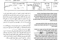
Palestinian residents of Faqqu'a village west of Jenin city received through registered mail 17 military orders sent to them by the Office of the Custodian of Absentee property and State Lands notifying them that more than 140 dunums of their agricultural lands were expropriated for the use of the Israeli Army.
All of the military orders received by Faqqu'a residents have the same number (06/67/T) and were issued to residents of Faqqu'a on September 17, 2006; however, the residents only got hold of them almost 6 months later to the date of issuance and the designated period set for objection against these orders had long passed. The targeted lands declared expropriated belong to 15 Palestinian residents from Faqqu'a village and table 1 below details information with regard to the 17 military orders:
Table 1: Detailed information of Military orders handed to Faqqu'a residents
|
|
Military Order Number |
Land Owner |
Block |
Parcel |
Area in dunums |
|
1 |
06/67/T |
Muhammad Ahmad Abdullah Barakat |
1 |
6 |
5.848 |
|
2 |
06/67/T |
2 |
6 |
11.999 |
|
|
3 |
06/67/T |
Abdel Rahman Younis Nadi |
2 |
12 |
2.594 |
|
4 |
06/67/T |
2 |
9 |
0.848 |
|
|
5 |
06/67/T |
Ali Ibrahim Mahmoud |
2 |
11 |
15.728 |
|
6 |
06/67/T |
2 |
8 |
0.798 |
|
|
7 |
06/67/T |
Muhammad Hussein Abu Hussein |
1 |
58 |
2.893 |
|
8 |
06/67/T |
2 |
10 |
9.92 |
|
|
9 |
06/67/T |
Tawfeeq Muhammad Nadi |
2 |
13 |
15.26 |
|
10 |
06/67/T |
2 |
5 |
3.592 |
|
|
11 |
06/67/T |
Fayez Hussein Abu Hussein |
1 |
57 |
8.829 |
|
12 |
06/67/T |
2 |
1 |
19.433 |
|
|
13 |
06/67/T |
Muhammad Younis Nadi |
2 |
13 |
19.197 |
|
14 |
06/67/T |
Abdel Latif Muhammad Yousni Jalghoum |
2 |
4 |
2.545 |
|
15 |
06/67/T |
Khalil Ahmad Odeh Zeidat |
2 |
2 |
6.686 |
|
16 |
06/67/T |
Mahmoud Khalil Ahmad Zeidat |
2 |
7 |
5.151 |
|
17 |
06/67/T |
Ali Ibrahim Masad |
2 |
14 |
9.242 |
|
Total |
140.563 |
||||
Source: Faqqu'a Village Council – 2007
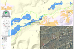
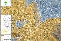
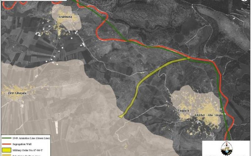
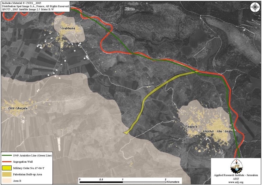
According to Faqqu'a village council review of the orders, the targeted lands slated for confiscation are to be used for the construction of an agricultural road that will lead to the 1949 Armistice Line (the Green Line) where an agricultural gate exist. The road leading to the agricultural gate is likely designated to facilitate marketing of Palestinian agricultural product to Israeli markets and Palestinian workers with permits to access nearby Israeli labor markets. See Map 1
Faqqu'a village; location and population
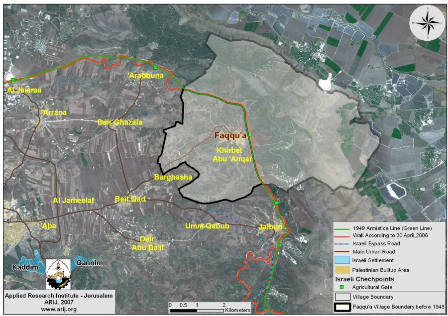
Faqqu'a village is located some 10 Km northeast of Jenin city, almost on the 1949 Armistice Line (Green Line). Before the 1948 war, Faqqu'a village lands spread across 32455 dunums where its boundaries extended eastwards beyond the 1949 Armistice Line (Green Line). Following the 1948 war, the village lost 67.4% (21875 dunums) of its original area into areas defined today as Israeli territory and the land area of 10580 dunums (32.6% of its original area) comprise Faqqu'a village today. See Map 2.
The population of Faqqu'a village recorded 553 inhabitants in the year 1922; however, according to the Palestinian National Information Center (PNIC), the population continued to increase over time to amount to 880, 1100 and 1800 inhabitants in the years 1945, 1967, and 1987, respectively. Today, the village's total population is 3500 according to the Palestinian Central Bureau of Statistics – 2006, where the village's built-up area spread on a total area of 354 dunums, about 3.4 % of the village's current area.
The 1949 Armistice Line (Green Line) bounds Faqqu'a village from the east and Deir Ghazala and Arbouna villages border it from the west and northwestern sides and Barghash village from the south.
Land Classification of Faqqu'a Village according to Oslo II Interim Agreement
The Oslo II Interim Agreement that was signed in September 1995 between the Palestinians and Israelis classified the occupied West Bank territory into three areas A, B, and C that aimed at a phased withdrawal of the Israeli military forces from these areas until the accomplishment of a final status agreement. Area A constitutes the areas where the Israeli army has pulled out fully and Palestinians have complete autonomy over administrative and security issues; Area A, according to the Oslo II agreement, covered the main cities of the West Bank, except for Hebron. Area B, Palestinians have full control over the civil responsibilities and Israel continues to have overriding responsibility for security; while Area (C): Palestinians have responsibility for civil life such as economy, health, and education; however, Israel retains full control over security and administration related to territory.
Accordingly, the 10580 dunums that constitute Faqqu'a Village lands were classified to areas B (4345 Dunums, 41%, where most of the built up area of the village is concentrated) and the remaining area of the village, a total of 6235 dunums were classified as Area C (58.9% of the total village area), which holds the village's agricultural lands and the open spaces. See Table 1
|
Table 1: Classification of Lands in Faqqu'a village according to Oslo II Agreement of 1995 |
||
|
Classification of Area |
Area in dunums |
% of the Village's total area |
|
Area A |
0 |
0 |
|
Area B |
4345 |
41.1 |
|
Area C |
6235 |
58.9 |
|
Total Area |
10580 |
100 |
|
ARIJ GIS Database 2006 |
||
The Israeli Segregation Wall hitting the lands of Faqqu'a village
In June 2002, the Israeli government launched its policy of unilateral segregation between Israel and the Palestinian territory by establishing a Segregation Zone along the western terrains of the occupied West Bank territory. The Israeli Segregation Zone covers substantial land areas, rich with natural resources (water aquifers) as it runs along and through the western part of the West Bank from north to south grabbing the most fertile agricultural lands, isolating Palestinian communities in enclaves, undermining the territorial contiguity between the Palestinian villages and cities, controlling the natural resources and encapsulating most of the Israeli settlements.
The village of Faqqu�a maybe considered of the Palestinian localities that suffered minimum physical damages to it lands in comparison to many other Palestinian localities as the Segregation Wall run for about 0.6 km on the eastern side of the village and isolates some 40 dunums behind it. however, the damages caused by the Segregation Wall goes beyond physical damages as all aspects of life have suffered the devastative upshots of the Wall; on the economy, education, health and social levels.
To conclude
The Israeli Practices are by all means a violation of UN resolution 242 (1967) drafted immediately after Israel occupied the West Bank and Gaza Strip and demands 'the withdrawal of all Israeli armed forces from the territories occupied' in the war. The requirements of Resolution 242 are re-enforced and strengthened by UN Security Council Resolutions 452 (1979) and 465 (1980).
Resolution 465 states categorically that: 'all measures taken by Israel to change the physical character, demographic composition, institutional structure of status of the Palestinian and other Arab territories occupied since 1967, including Jerusalem, or any part thereof, have no legal validity and that Israel's policy and practices of setting parts of its population and new Immigrants in those territories constitute a flagrant violation of the Fourth Geneva Convention Relative to the Protection of Civilian Persons in Time of War and also constitute a serious obstruction to achieving a comprehensive, just and lasting peace in the Middle East. '
Israeli practices are also a flagrant violation of international humanitarian law, specifically The Hague Regulations of 1907 and the Fourth Geneva Convention of 1949
-
The Hague Regulations of 1907, article 23 which forbids an occupying power 'to destroy or seize the enemy's property, unless such destruction or seizure be imperatively demanded by the necessities of war'.
-
Article 53 of the Fourth Geneva Convention is also clear that: 'any destruction by the Occupying Power of real or personal property belonging individually or collectively to private persons, or to the State, or to other public authorities, or to social or cooperative organizations, is prohibited, except where such destruction is rendered absolutely necessary by military operations.'
-
Article 147 of the Fourth Geneva Convention, of which clearly prohibits, ''extensive destruction and appropriation of property, not justified by military necessity and carried out unlawfully and wantonly.''
Prepared by
The Applied Research Institute – Jerusalem
ARIJ