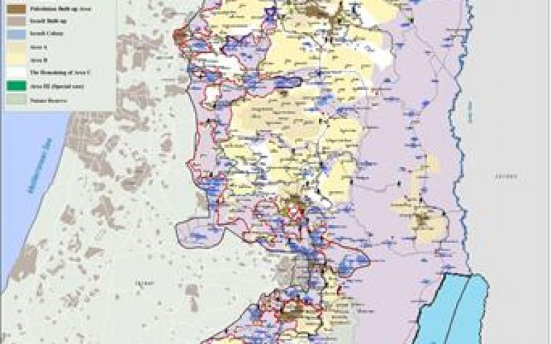
The Segregation Wall which Israel claims necessary to stop Palestinians from entering Israel, runs along the Artimistic line (Green line) inside the West Bank. The Segregation Wall penetrates the West Bank to depths that reach from 6 kilometers east of the Artimistic line (Green line) to 23 kilometers to the east of Ariel Settlement. See latest map of the Segregation Wall.
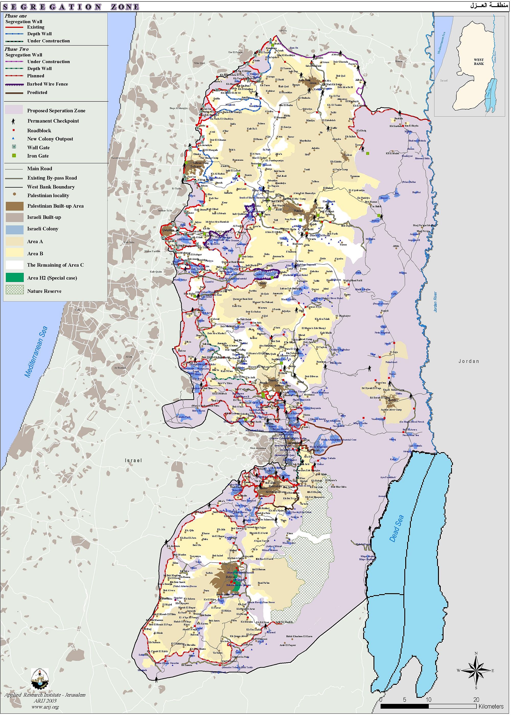
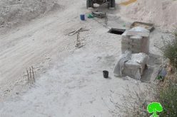
The destruction of land has left many Palestinians in a desperate economic situation as most of the areas confiscated for the Segregation Wall are agricultural areas. The agricultural activities comprise the main source of income for the Palestinian citizens living in these communities. More than 120000 dunums of land have been confiscated for colonial expansion activities and the construction of the Segregation Wall. According to ARIJ database, a total of 352807 trees were uprooted in various Israeli activities.
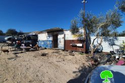
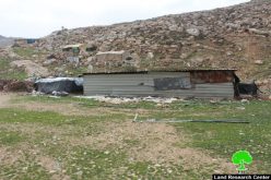
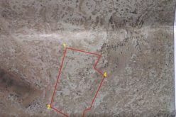
Israeli chief commander Mosheh Kaplenski, handed the landlords of Bardala, Al Raba, Al Mugheir villages and Tubas city, in the northern valleys of the West Bank, military orders to confiscate 424 dunums of the agricultural land under the pretext of security reasons. Orders were distributed on the 5th of November 2003 which definitely show the plan to strangulate the villages by confiscating their lands and annexing them to Israel. See Map of military order in Tubas
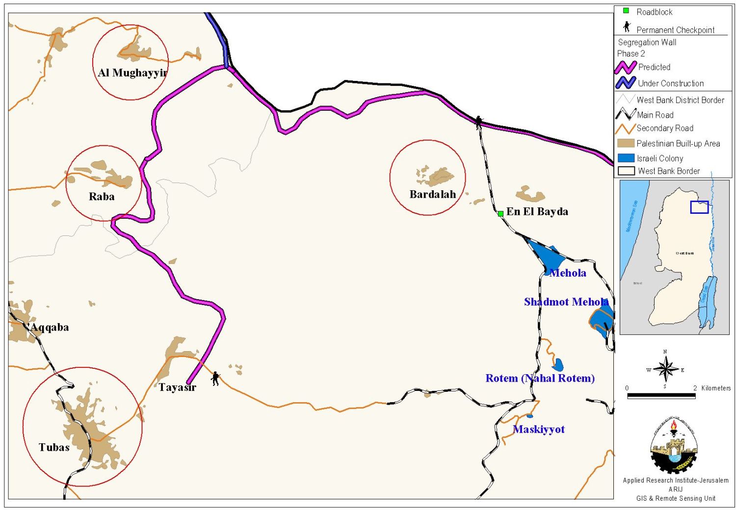
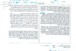
ARIJ fieldworkers were able to get a copy of the military orders in Al Mugheir and names of people affected due to the Israeli colonization activities. The military order number (03/81/T Judea & Samaria 2003) that was distributed shows the blocks and parcels of lands seized to be confiscated and are classified in the following table:
Table 1: shows the block No., Parcel No., area in dunums and type of uprooted trees in Al Mugheir village:
|
Owner |
Block No. |
Parcel No. |
Area in dunums |
Type of Trees uprooted |
|
Sa'ed Husein Mustafa Abu Muwais |
5 |
1 |
20.419 |
Filed crops (Wheat) |
|
Sa'ed Husein Mustafa Abu Muwais |
4 |
19 |
3.760 |
Vegetables |
|
Sa'ed Husein Mustafa Abu Muwais |
1 |
10 |
10.856 |
Vegetables and Wheat |
|
Sa'ed Sulaiman Yousef Abu Muwais |
4 |
18 |
2.518 |
Vegetables and Wheat |
|
Muhammad Mahmoud Yousef Abu Muwais |
2 |
20 |
19.480 |
Vegetables and field crops |
|
Amin Mahmoud Yousef Abu Muwais |
2 |
21 |
12.460 |
Vegetables and Wheat |
|
Nemer Salim Ali Abu Muwais |
5 |
33 |
8.268 |
Olives |
|
Mahmoud Muhammad ahmad abu Muwais |
5 |
32 |
8.668 |
Olives |
|
Muhammad Abdel Qader Ali Abu Muwais |
5 |
31 |
7.154 |
Olives |
|
Suad Mahmoud Yousef Abu Muwais |
4 |
26 |
8.89 |
Vegetables and Wheat |
|
Jamil Qasem Ali Abu Muwais |
5 |
8 |
10.538 |
Olives |
|
|
1 |
6 |
15.631 |
Vegetables and Wheat |
|
Muhammad Mahmoud Yousef Abu Muwais |
2 |
|
26 |
Vegetables and Wheat |
|
Sa'ed Mahmoud Yousef Idris |
2 |
|
30 |
Vegetables and Wheat |
|
Hasan Mahmoud Yousef Abu Muwais |
2 |
|
21 |
Vegetables and Wheat |
|
Ahmad Abdullah Mahmoud Abu Muwais |
2 |
|
19 |
Vegetables and Wheat |
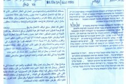
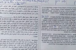
See copy of military order (Page 1 & Page 2)
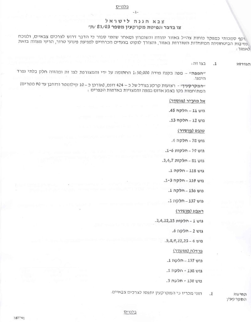
Military Order's Translation
Israel Defense Forces
Order to Seize lands n0 03/81/T
According to my authorities as a Military Chief Commander in the Region of Judea and Samaria, and as I believe that it is imperative for military reasons due to the special security situation in the region, I order the following:
1. The ''Map'' signed with a scale of 1: 50000 and attached to the order is an essential part of this order. The ''Lands'' : An area of land which is 424 dunums marked in red in the map:
a. Al Mugheir village:
- Block 11: parcels 45
- Block 12: parcels 13
b. Bardala village:
- Block 137: parcel 1
- Block 138: parcel 1
- Block 139: parcels 2
c. Al Raba village:
- Block 1: parcels 4
- Block 2: parcels 6
- Block 4: parcels 3,8,9,22,23
d. Tubas:
- Block 78: parcels 4
- Block 79: parcels 1 to 6
- Block 81: parcels 3,4,7
- Block 118: parcel 1
- Block 114: parcels 1 to 3
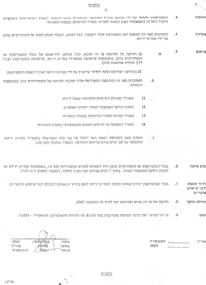
2. I announce by that the above mentioned lands are seized for military reasons.
3. The IOF seize the lands and have an absolute control over it that is given to the officer of the central command officer of lands who is responsible in the ministry of defense.
4. These copies are to be given by the District Co-ordination Office ''The DCO'' of Bethlehem to the owners of land.
5. Copies are found with maps for those who are interested in the following places :
- District coordination office (DCO) of Ramallah.
- Offices of the Juridical advisor in the region.
- The office of commander responsible in the ministry of defense in the civil administration.
- Office responsible of absentee and public lands in the civil administration.
6. The owners of land have the right to go to the DCO in Ramallah in order to get more information about their right of land use expenses and compensation.
7. The Validity of this order starts at the date signed till 31/5/2004.
8. The name of this order is: ''Order to seize lands n0 03/81/T (Judea & Samaria ) 2003.
Mosheh Kaplenski
Chief Commander of The Israel Defense Forces in Judea & Samaria
-Signature
According to the military order, the IOF (Israeli Occupation Forces) has the right to use the land for any purpose and under any pretext. The village of Al Mugheir and the areas around are just one of the many cases of communities that are fatally affected by Israel's military attempt to annex Palestinian lands for the Segregation Wall. Thus, Israel continues to cause great hardship to thousands of Palestinians and forms a 'grave obstacle' to the implementation of all peace agreements in the middle east and goes against the creation of a viable Palestinian.
Prepared by:
The Applied Research Institute – Jerusalem